Hubbry Logo
Passive marginPassive marginMain
Open search
Passive margin
Community hub
Passive margin
logo
8 pages, 0 posts
0 subscribers
Be the first to start a discussion here.
Passive margin
Passive margin
from Wikipedia
Rifting-to-spreading transition
Passive continental margin

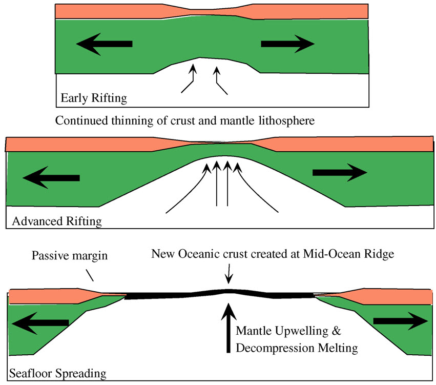
A passive margin is the transition between oceanic and continental lithosphere that is not an active plate margin. A passive margin forms by sedimentation above an ancient rift, now marked by transitional lithosphere. Continental rifting forms new ocean basins. Eventually the continental rift forms a mid-ocean ridge and the locus of extension moves away from the continent-ocean boundary. The transition between the continental and oceanic lithosphere that was originally formed by rifting is known as a passive margin.

In summary, passive margins represent broad, non-tectonically active transitions between continental and oceanic lithosphere that evolve from continental rifting to seafloor spreading and subsequent thermal subsidence, producing extensive sedimentary wedges above highly attenuated transitional crust. Recent studies emphasize that passive margin architecture varies laterally over short distances with changes in crustal extension and magmatic flux, leading to magma-poor, magma-rich e intermediate margin segments that influence crustal structure, subsidence history and sediment distribution. These heterogeneities affect basin evolution, resource potential and margin morphology along rifted continental margins.

Global distribution

[edit]
Map showing the distribution of Earth's passive margins.

Passive margins are found at every ocean and continent boundary that is not marked by a strike-slip fault or a subduction zone. Passive margins define the region around the Arctic Ocean, Atlantic Ocean, and western Indian Ocean, and define the entire coasts of Africa, Australia, Greenland, and the Indian Subcontinent. They are also found on the east coast of North America and South America, in Western Europe and most of Antarctica. Northeast Asia also contains some passive margins.

Key components

[edit]

Active vs. passive margins

[edit]

The distinction between active and passive margins refers to whether a crustal boundary between oceanic lithosphere and continental lithosphere is a plate boundary. Active margins are found on the edge of a continent where subduction occurs. These are often marked by uplift and volcanic mountain belts on the continental plate. Less often there is a strike-slip fault, as defines the southern coastline of West Africa. Most of the eastern Indian Ocean and nearly all of the Pacific Ocean margin are examples of active margins. While a weld between oceanic and continental lithosphere is called a passive margin, it is not an inactive margin. Active subsidence, sedimentation, growth faulting, pore fluid formation and migration are all active processes on passive margins. Passive margins are only passive in that they are not active plate boundaries.

Morphology

[edit]
Bathymetric profile across a typical passive margin. Note that vertical scale is greatly exaggerated relative to the horizontal scale.

Passive margins consist of both onshore coastal plain and offshore continental shelf-slope-rise triads. Coastal plains are often dominated by fluvial processes, while the continental shelf is dominated by deltaic and longshore current processes. The great rivers (Amazon, Orinoco, Congo, Nile, Ganges, Yellow, Yangtze, and Mackenzie rivers) drain across passive margins. Extensive estuaries are common on mature passive margins. Although there are many kinds of passive margins, the morphologies of most passive margins are remarkably similar. Typically they consist of a continental shelf, continental slope, continental rise, and abyssal plain. The morphological expression of these features are largely defined by the underlying transitional crust and the sedimentation above it. Passive margins defined by a large fluvial sediment budget and those dominated by coral and other biogenous processes generally have a similar morphology. In addition, the shelf break seems to mark the maximum Neogene lowstand, defined by the glacial maxima. The outer continental shelf and slope may be cut by great submarine canyons, which mark the offshore continuation of rivers.

At high latitudes and during glaciations, the nearshore morphology of passive margins may reflect glacial processes, such as the fjords of Greenland and Norway.

Cross-section

[edit]
Transitional crust composed of stretched and faulted continental crust. Note: vertical scale is greatly exaggerated relative to horizontal scale.
Cross-section through transitional crust of a passive margin. Transitional crust as a largely volcanic construct. Note: vertical scale is greatly exaggerated relative to horizontal scale.

The main features of passive margins lie underneath the external characters. Beneath passive margins the transition between the continental and oceanic crust is a broad transition known as transitional crust. The subsided continental crust is marked by normal faults that dip seaward. The faulted crust transitions into oceanic crust and may be deeply buried due to thermal subsidence and the mass of sediment that collects above it. The lithosphere beneath passive margins is known as transitional lithosphere. The lithosphere thins seaward as it transitions seaward to oceanic crust. Different kinds of transitional crust form, depending on how fast rifting occurs and how hot the underlying mantle was at the time of rifting. Volcanic passive margins represent one endmember transitional crust type, the other endmember (amagmatic) type is the rifted passive margin. Volcanic passive margins also are marked by numerous dykes and igneous intrusions within the subsided continental crust. There are typically a lot of dykes formed perpendicular to the seaward-dipping lava flows and sills. Igneous intrusions within the crust cause lava flows along the top of the subsided continental crust and form seaward-dipping reflectors.

Subsidence mechanisms

[edit]

Passive margins are characterized by thick accumulations of sediments. Space for these sediments is called accommodation and is due to subsidence of especially the transitional crust. Subsidence is ultimately caused by gravitational equilibrium that is established between the crustal tracts, known as isostasy. Isostasy controls the uplift of the rift flank and the subsequent subsidence of the evolving passive margin and is mostly reflected by changes in heat flow. Heat flow at passive margins changes significantly over its lifespan, high at the beginning and decreasing with age. In the initial stage, the continental crust and lithosphere is stretched and thinned due to plate movement (plate tectonics) and associated igneous activity. The very thin lithosphere beneath the rift allows the upwelling mantle to melt by decompression. Lithospheric thinning also allows the asthenosphere to rise closer to the surface, heating the overlying lithosphere by conduction and advection of heat by intrusive dykes. Heating reduces the density of the lithosphere and elevates the lower crust and lithosphere. In addition, mantle plumes may heat the lithosphere and cause prodigious igneous activity. Once a mid-oceanic ridge forms and seafloor spreading begins, the original site of rifting is separated into conjugate passive margins (for example, the eastern US and NW African margins were parts of the same rift in early Mesozoic time and are now conjugate margins) and migrates away from the zone of mantle upwelling and heating and cooling begins. The mantle lithosphere below the thinned and faulted continental oceanic transition cools, thickens, increases in density and thus begins to subside. The accumulation of sediments above the subsiding transitional crust and lithosphere further depresses the transitional crust.

Classification

[edit]

There are four different perspectives needed to classify passive margins:

  1. map-view formation geometry (rifted, sheared, and transtensional),
  2. nature of transitional crust (volcanic and non-volcanic),
  3. whether the transitional crust represents a continuous change from normal continental to normal oceanic crust or this includes isolated rifts and stranded continental blocks (simple and complex), and
  4. sedimentation (carbonate-dominated, clastic-dominated, or sediment starved).

The first describes the relationship between rift orientation and plate motion, the second describes the nature of transitional crust, and the third describes post-rift sedimentation. All three perspectives need to be considered in describing a passive margin. In fact, passive margins are extremely long, and vary along their length in rift geometry, nature of transitional crust, and sediment supply; it is more appropriate to subdivide individual passive margins into segments on this basis and apply the threefold classification to each segment.

Geometry of passive margins

[edit]

Rifted margin

[edit]

This is the typical way that passive margins form, as separated continental tracts move perpendicular to the coastline. This is how the Central Atlantic opened, beginning in Jurassic time. Faulting tends to be listric: normal faults that flatten with depth.

Sheared margin

[edit]

Sheared margins form where continental breakup was associated with strike-slip faulting. A good example of this type of margin is found on the south-facing coast of west Africa. Sheared margins are highly complex and tend to be rather narrow. They also differ from rifted passive margins in structural style and thermal evolution during continental breakup. As the seafloor spreading axis moves along the margin, thermal uplift produces a ridge. This ridge traps sediments, thus allowing for thick sequences to accumulate. These types of passive margins are less volcanic.

Transtensional margin

[edit]

This type of passive margin develops where rifting is oblique to the coastline, as is now occurring in the Gulf of California.

Nature of transitional crust

[edit]

Transitional crust, separating true oceanic and continental crusts, is the foundation of any passive margin. This forms during the rifting stage and consists of two endmembers: volcanic and non-volcanic. This classification scheme only applies to rifted and transtensional margin; transitional crust of sheared margins is very poorly known.

Non-volcanic rifted margin

[edit]

Non-volcanic margins are formed when extension is accompanied by little mantle melting and volcanism. Non-volcanic transitional crust consists of stretched and thinned continental crust. Non-volcanic margins are typically characterized by continentward-dipping seismic reflectors (rotated crustal blocks and associated sediments) and low P wave velocities (<7.0 km/s) in the lower part of the transitional crust.

Volcanic rifted margin

[edit]

Volcanic margins form part of large igneous provinces, which are characterised by massive emplacements of mafic extrusives and intrusive rocks over very short time periods. Volcanic margins form when rifting is accompanied by significant mantle melting, with volcanism occurring before and/or during continental breakup. The transitional crust of volcanic margins is composed of basaltic igneous rocks, including lava flows, sills, dykes, and gabbro.

Volcanic margins are usually distinguished from non-volcanic (or magma-poor) margins (e.g. the Iberian margin, Newfoundland margin) which do not contain large amounts of extrusive and/or intrusive rocks and may exhibit crustal features such as unroofed, serpentinized mantle. Volcanic margins are known to differ from magma-poor margins in a number of ways:

  • A transitional crust composed of basaltic igneous rocks, including lava flows, sills, dykes, and gabbros
  • A huge volume of basalt flows, typically expressed as seaward-dipping reflector sequences (SDRS) rotated during the early stages of crustal accretion (breakup stage)
  • The presence of numerous sill/dyke and vent complexes intruding into the adjacent basin
  • The lack of significant passive-margin subsidence during and after breakup
  • The presence of a lower crust with anomalously high seismic P wave velocities (Vp=7.1-7.8 km/s) – referred to as lower crustal bodies (LCBs) in the geologic literature

The high velocities (Vp > 7 km) and large thicknesses of the LCBs are evidence that supports the case for plume-fed accretion (mafic thickening) underplating the crust during continental breakup. LCBs are located along the continent-ocean transition but can sometimes extend beneath the continental part of the rifted margin (as observed in the mid-Norwegian margin for example). In the continental domain, there are still open discussion on their real nature, chronology, geodynamic and petroleum implications.[1]

Examples of volcanic margins:

  • The Yemen margin
  • The East Australian margin
  • The West Indian margin
  • The Hatton-Rockal margin
  • The U.S. East Coast
  • The mid-Norwegian margin
  • The Brazilian margins
  • The Namibian margin
  • The East Greenland margin
  • The West Greenland margin

Examples of non-volcanic margins:

  • The Newfoundland Margin
  • The Iberian Margin
  • The Margins of the Labrador Sea (Labrador and Southwest Greenland)

Heterogeneity of transitional crust

[edit]

Simple transitional crust

[edit]

Passive margins of this type show a simple progression through the transitional crust, from normal continental to normal oceanic crusts. The passive margin offshore Texas is a good example.

Complex transitional crust

[edit]

This type of transitional crust is characterized by abandoned rifts and continental blocks, such as the Blake Plateau, Grand Banks, or Bahama Islands offshore eastern Florida.

Sedimentation

[edit]

A fourth way to classify passive margins is according to the nature of sedimentation of the mature passive margin. Sedimentation continues throughout the life of a passive margin. Sedimentation changes rapidly and progressively during the initial stages of passive margin formation because rifting begins on land, becoming marine as the rift opens and a true passive margin is established. Consequently, the sedimentation history of a passive margin begins with fluvial, lacustrine, or other subaerial deposits, evolving with time depending on how the rifting occurred and how, when, and by what type of sediment it varies.

Constructional

[edit]

Constructional margins are the "classic" mode of passive margin sedimentation. Normal sedimentation results from the transport and deposition of sand, silt, and clay by rivers via deltas and redistribution of these sediments by longshore currents. The nature of sediments can change remarkably along a passive margin, due to interactions between carbonate sediment production, clastic input from rivers, and alongshore transport. Where clastic sediment inputs are small, biogenic sedimentation can dominate especially nearshore sedimentation. The Gulf of Mexico passive margin along the southern United States is an excellent example of this, with muddy and sandy coastal environments down current (west) from the Mississippi River Delta and beaches of carbonate sand to the east. The thick layers of sediment gradually thin with increasing distance offshore, depending on subsidence of the passive margin and the efficacy of offshore transport mechanisms such as turbidity currents and submarine channels.

Development of the shelf edge and its migration through time is critical to the development of a passive margin. The location of the shelf edge break reflects complex interaction between sedimentation, sealevel, and the presence of sediment dams. Coral reefs serve as bulwarks that allow sediment to accumulate between them and the shore, cutting off sediment supply to deeper water. Another type of sediment dam results from the presence of salt domes, as are common along the Texas and Louisiana passive margin.

Starved

[edit]

Sediment-starved margins produce narrow continental shelves and passive margins. This is especially common in arid regions, where there is little transport of sediment by rivers or redistribution by longshore currents. The Red Sea is a good example of a sediment-starved passive margin.

Formation

[edit]

There are three main stages in the formation of passive margins:

  1. In the first stage a continental rift is established due to stretching and thinning of the crust and lithosphere by plate movement. This is the beginning of the continental crust subsidence. Drainage is generally away from the rift at this stage.
  2. The second stage leads to the formation of an oceanic basin, similar to the modern Red Sea. The subsiding continental crust undergoes normal faulting as transitional marine conditions are established. Areas with restricted sea water circulation coupled with arid climate create evaporite deposits. Crust and lithosphere stretching and thinning are still taking place in this stage. Volcanic passive margins also have igneous intrusions and dykes during this stage.
  3. The last stage in formation happens only when crustal stretching ceases and the transitional crust and lithosphere subsides as a result of cooling and thickening (thermal subsidence). Drainage starts flowing towards the passive margin causing sediment to accumulate over it.

Economic significance

[edit]

Passive margins are important exploration targets for petroleum. Mann et al. (2001) classified 592 giant oil fields into six basin and tectonic-setting categories, and noted that continental passive margins account for 31% of giants. Continental rifts (which are likely to evolve into passive margins with time) contain another 30% of the world's giant oil fields. Basins associated with collision zones and subduction zones are where most of the remaining giant oil fields are found.

Passive margins are petroleum storehouses because these are associated with favorable conditions for accumulation and maturation of organic matter. Early continental rifting conditions led to the development of anoxic basins, large sediment and organic flux, and the preservation of organic matter that led to oil and gas deposits. Crude oil will form from these deposits. These are the localities in which petroleum resources are most profitable and productive. Productive fields are found in passive margins around the globe, including the Gulf of Mexico, western Scandinavia, and Western Australia.

Law of the Sea

[edit]

International discussions about who controls the resources of passive margins are the focus of law of the sea negotiations. Continental shelves are important parts of national exclusive economic zones, important for seafloor mineral deposits (including oil and gas) and fisheries.

See also

[edit]

References

[edit]
Revisions and contributorsEdit on WikipediaRead on Wikipedia
from Grokipedia
A passive margin constitutes the interface between continental and oceanic lithosphere absent an active plate boundary, arising from continental rifting succeeded by that yields extended, thinned capped by substantial sedimentary deposits. This process fundamentally drives the structural evolution, commencing with lithospheric extension and faulting that thins the crust, followed by thermal as heat dissipates, facilitating prolonged sediment accumulation from erosional products of adjacent landmasses. Passive margins characteristically possess expansive continental shelves, subdued slopes devoid of subduction-related trenches, and subdued seismicity alongside sparse , contrasting sharply with the dynamic deformation at convergent or transform boundaries. Prominent instances encompass the Atlantic coasts of North and , , and , relics of the Pangea supercontinent's fragmentation. These margins underpin vast sedimentary basins that host prolific systems, wherein organic-rich source rocks, reservoirs, and seals develop through rift-phase syntectonic deposition and subsequent post-rift transgression. Their geological quiescence belies profound economic import, with mechanisms governed by isostatic equilibrium and asthenospheric cooling dictating long-term basin architecture.

Definition and Fundamental Characteristics

Distinction from Active Margins

Active continental margins coincide with convergent or transform plate boundaries, characterized by intense tectonic deformation, frequent earthquakes, and volcanic activity due to or lateral shearing of plates. In contrast, passive margins represent the stable, non-boundary transition from continental to , lacking ongoing plate interactions and exhibiting minimal and . Morphologically, active margins feature narrow continental shelves, steep slopes, and deep oceanic trenches formed by erosion or accretionary prisms, which limit sediment retention and promote rapid . Passive margins, however, display wide shelves (often exceeding 200 km), gentler slopes, and prominent continental rises built from thick wedges deposited during post-rift without tectonic disruption. This sedimentary thickness on passive margins can reach several kilometers, fostering reservoirs, as observed along the U.S. Atlantic margin. Tectonically, the absence of plate boundary forces on passive margins results in isostatic driven by cooling rather than compression or extension, leading to long-term stability over tens of millions of years post-rifting. Active margins dynamic uplift, folding, and faulting from plate convergence, with examples like the Peru-Chile illustrating subduction-related deformation rates of centimeters per year. Such differences underscore passive margins' role in accommodating influx without the destructive seen at active zones.

Morphological and Structural Features

Passive continental margins display characteristic bathymetric provinces resulting from prolonged thermal subsidence, crustal thinning, and sediment deposition, comprising a broad continental shelf, a gently inclined continental slope, a depositional continental rise, and an adjacent abyssal plain. These features lack the steep trenches or active fault scarps typical of convergent margins, reflecting tectonic stability post-rifting. The continental shelf forms the shallow, seaward extension of the continental platform, with widths averaging 80 kilometers globally but often broader on passive margins—up to 500 kilometers in examples like the U.S. Atlantic coast—due to extensive sediment infill and isostatic adjustment; water depths remain under 150 meters, with minimal slopes of approximately 0.1 degrees. The shelf break, typically at 135-200 meters depth, delineates the onset of steeper terrain. Seaward of the shelf break lies the continental slope, descending to 3,000-5,000 meters depth over distances of 20-100 kilometers, with average inclinations of 2-4 degrees; this zone is incised by submarine canyons, such as the off New York, which channel sediments via turbidity currents to deeper realms. The continental rise accumulates as a wedge-shaped apron of fine-grained sediments at the slope's toe, extending hundreds of kilometers basinward with very low gradients less than 1 degree, built primarily by fans and hemipelagic fallout before grading into the flat at roughly 5,000 meters depth. Structurally, passive margins overlie variably thinned (10-30 kilometers thick) transitional to , with inherited rift basins and normal faults largely buried beneath kilometers-thick sedimentary prisms, fostering hydrocarbon-rich basins but minimal ongoing or .

Subsurface Cross-Sectional Composition

The subsurface cross-section of a passive margin illustrates a seaward transition from thick to thinned extended crust, a transitional zone, and finally , overlain by variably thick sedimentary sequences. Proximal domains feature typically 30-35 km thick, composed of upper crust and lower crust, faulted during rifting into basins filled with syn-rift sediments such as conglomerates and sandstones. Post-rift thermal generates a wedge of transgressive sediments, including shales, limestones, and sandstones, accumulating up to 10-15 km thick on the continental shelf and slope, as observed in the Baltimore Canyon Trough where sediments reach 13 km depth. In distal regions, crustal extension necks the continental crust to thicknesses below 10 km, often exposing or exhuming mantle peridotite in magma-poor margins, with seismic profiles revealing high-velocity lower crustal bodies or detachment faults facilitating hyper-extension. The continent-ocean transition (COT) spans 50-100 km, characterized by crust 5-15 km thick, including serpentinized mantle with velocities of 7.0-7.5 km/s, grading into averaging 7 km thick formed by . Sedimentary cover in the COT includes deep-water turbidites and mass-transport deposits on the , thinning to pelagic sediments on the rise and . Structural features in cross-sections, derived from seismic reflection and wide-angle data, show listric normal faults rooting into the lower crust or mantle, a post-rift marking of 1-6 km, and subsequent onlap of drift-phase sequences. For instance, along the eastern North American margin, cumulative extension heave reaches 4-19 km, with exceeding 10 km near the boundary, reflecting prerift orogenic influences on postrift architecture. Variations occur between magma-rich margins with intrusive sills and volcanic sequences, and magma-poor ones with pronounced hyper-extension.

Formation and Evolutionary Processes

Initial Rifting and Continental Breakup

The initial phase of rifting in passive margin formation involves that progressively thin the continental through a combination of brittle faulting in the upper crust and ductile deformation in the lower crust and mantle. This process typically begins with the development of basins, such as half-grabens bounded by listric normal faults, where syn-rift accumulates, often accompanied by minor depending on the thermal state of the . Extension factors, quantified as β (initial thickness divided by final thickness), commonly range from 1.5 to over 5 in hyper-extended margins, leading to significant crustal . Theoretical models for this rifting emphasize pure-shear deformation, where the undergoes uniform symmetric stretching, promoting asthenospheric and adiabatic decompression in some cases, though passive rifting is distinguished from active mantle-driven by its response to far-field tensile stresses rather than pre-existing plumes. In contrast, simple-shear models invoke asymmetric detachment faults, but seismic data from many margins support predominantly symmetric extension during early stages. The transition to occurs when lithospheric strength is sufficiently reduced, often marked by a necking zone of rapid thinning, exhumation of lower crustal and mantle rocks, and in magma-poor settings, serpentinization of due to hydration. Continental breakup signifies the rupture of the , initiating and the onset of formation at the nascent . This diachronous process varies by region; for instance, in the Central Atlantic, rifting initiated around 230 Ma during the , progressing to breakup and between 175 and 195 Ma in the . In the North Atlantic, polyphase rifting spanned the Permian to , with final breakup between and northwest occurring approximately 55 Ma ago, influenced by the . Similarly, the South Atlantic experienced initial rifting in the followed by breakup around 130 Ma in the , transitioning from continental to oceanic domains. These timelines, derived from data and of rift-related igneous rocks, underscore the prolonged nature of rifting, often exceeding 50 million years before successful ocean basin formation.

Subsidence and Thermal Mechanisms

Following the cessation of rifting and onset of , passive margins undergo extended phases of dominated by lithospheric cooling and thermal contraction. During the syn-rift phase, thin the , often accompanied by asthenospheric that elevates the margin through ; post-rift, heat dissipates primarily via conduction to the surface, reducing the lithosphere's thickness and inducing contraction that lowers the surface isostatically. This process aligns with the McKenzie (1978) pure-shear stretching model, where uniform lithospheric extension by a factor β (typically 1.5–3 for many margins) predicts exponential decay over 100–200 million years, with initial rapid descent followed by slower rates matching observed backstripped basin data from margins like the . Thermal subsidence creates substantial accommodation space, enabling deposition of thick sedimentary wedges (up to 10–15 km in places like the U.S. East Coast margin), which further enhance subsidence through flexural loading on the elastic lithosphere. The cooling follows a conductive half-space , with subsidence magnitude scaling with initial β and inversely with crustal heat production; for β=2, modeled depths reach ~2–3 km after 50 Ma, corroborated by vitrinite reflectance and paleotemperature profiles. Deviations from ideal models arise in magma-rich margins, where excess sustains elevated geothermal gradients and delays full cooling, as evidenced by higher β equivalents (up to 6) in the Norwegian margin. While sediment loading amplifies via Airy , the primary driver remains , with rates diminishing from ~50–100 m/Myr initially to <10 m/Myr after 100 Ma, as quantified in forward models calibrated to seismic stratigraphy. Flexural rigidity variations, influenced by inherited crustal heterogeneity, modulate this response, but empirical fits to global margins confirm thermal contraction's causal primacy over alternative mechanisms like dynamic topography in non-plume settings.

Post-Rift Evolution and Potential Conversion to Active Margins

Following continental breakup and the onset of seafloor spreading, passive margins enter a post-rift phase characterized by thermal cooling of the extended lithosphere, which drives progressive subsidence through contraction and densification of the mantle. This subsidence facilitates the accumulation of thick sedimentary sequences, often exceeding 10 km in basins like the , where post-rift deposits include clastic and carbonate layers deposited under varying sea-level conditions. Thermal models predict subsidence rates decreasing exponentially over 50-100 million years, from initial highs of ~100 m/Myr to long-term averages below 10 m/Myr, influenced by the initial rift depth and crustal thickness. Anomalous vertical movements, such as episodic uplift or renewed subsidence, can occur due to dynamic topography from mantle convection or sediment loading, as observed in the eastern North American margin where post-rift exhumation phases alternated with burial linked to cooling-heating cycles. Post-rift magmatism, though less voluminous than during rifting, persists in some margins due to residual lithospheric extension, edge-driven convection, or hotspot interactions, producing alkaline basalts and intrusive bodies. For instance, the eastern North American margin experienced magmatism from the Early Jurassic to Miocene, with chemical signatures indicating asthenospheric upwelling rather than plume dominance, constraining the transition from rift to drift. In volcanic passive margins, such as parts of the North Atlantic, post-rift igneous provinces form seaward-dipping reflectors and sills, enhancing crustal thickness and altering subsidence patterns compared to non-volcanic margins. Geomorphological evolution involves escarpment retreat and fluvial incision, with low tectonic rates promoting long-wavelength erosion, as evidenced in elevated passive margins where denudation rates average 10-30 m/Myr over Cenozoic timescales. While most passive margins remain tectonically quiescent for tens to hundreds of millions of years—averaging ~104 Ma lifespan before potential reactivation—their conversion to active margins requires external plate-scale forces, typically involving subduction initiation. Direct subduction of old, buoyant oceanic lithosphere beneath passive margins is mechanically resisted due to low density contrasts and thick sediments, but conversion occurs via subduction polarity reversal following arc-continent collision, where the overriding plate's arc accretes to the passive margin, inducing back-arc spreading and trench retreat. Examples include the Taiwan orogen, where the Philippine Sea plate's subduction reversed after collision with the Eurasian passive margin, propagating southwestward at ~95 km/Myr and forming an Andean-type margin. Lateral propagation of adjacent subduction zones can also initiate weakness-exploiting subduction at passive margins, as modeled for intra-oceanic settings, though empirical cases like the Australia-Timor collision highlight sediment subduction and ophiolite obduction as precursors. Such transitions are rare and geologically rapid, often spanning <10 Myr, underscoring the role of inherited crustal heterogeneity in facilitating reactivation over pristine post-rift stability.

Classification Schemes

Geometric Configurations

Rifted passive margins, the most common geometric configuration, form through orthogonal extension perpendicular to the continental margin during breakup, resulting in a broad zone of thinned continental crust, extensional fault blocks, and a gradual seaward transition to oceanic crust over distances of tens to hundreds of kilometers. This geometry is characterized by rift basins symmetric or asymmetric in cross-section, with half-graben structures and significant syn-rift sedimentation. Examples include the majority of Atlantic margins, such as the eastern North American continental margin and its conjugate off northwest Africa, where rifting initiated in the Late Triassic to Early Jurassic around 230–180 million years ago. Sheared passive margins develop where continental separation occurs primarily through strike-slip motion along transform faults, leading to an abrupt, near-vertical lateral transition from continental to oceanic crust, often with minimal stretched crust and prominent marginal highs or plateaus. These margins exhibit steep continental slopes due to fault control and limited sediment draping, contrasting with the gentler gradients of rifted types, and may feature inherited transform offsets influencing post-breakup sedimentation. Representative examples are the margin adjacent to the Agulhas Fracture Zone south of South Africa and the Barents Sea margin in the Norwegian Sea, both displaying sharp structural discontinuities. Hybrid or transtensional configurations combine elements of rifting and shearing, arising from oblique extension where divergence includes a significant strike-slip component, producing segmented margins with en-échelon fault arrays, pull-apart basins, and flower structures. This geometry results in variable crustal thinning along strike and complex fault patterns accommodating both extension and shear. Instances occur in sheared-rifted transitions, such as from northeastern Greenland to western Svalbard, where initial transform motion evolves into spreading.

Transitional Crust Types

Transitional crust in passive margins occupies the continent-ocean transition (COT) zone, where continental lithosphere grades into oceanic lithosphere through extreme extension, faulting, and variable magmatism during rifting and breakup. This domain typically spans 20-200 km horizontally and features crustal thicknesses reduced to less than 10 km in hyper-extended segments, distinguishing it from undeformed continental crust (30-40 km thick) and normal oceanic crust (6-7 km thick). Seismic refraction and reflection data reveal heterogeneous compositions, including faulted continental blocks, ductile lower crustal remnants, and intrusive bodies, with velocities intermediate between continental (6.0-7.0 km/s) and oceanic (5.0-6.5 km/s) crust. Hyper-extended continental crust represents one primary type, formed by brittle-ductile stretching factors exceeding 200-300%, coupling upper and lower crust to enable deep-penetrating detachment faults that thin the lithosphere without significant magmatism. In such domains, preserved continental affinities include high seismic velocities (>7.0 km/s) from lower crust or metasediments, but overall embrittlement allows exhumation of subcontinental mantle in magma-poor settings like the Iberia-Newfoundland conjugate margins, where serpentinized peridotites outcrop over 150 km wide zones. These exhumed mantle rocks, with P-wave velocities of 4.5-7.5 km/s due to hydration, form a high transitional to true , often capped by thin sediments and lacking a magnetic signature typical of gabbroic oceanic layers. In contrast, transitional crust at magma-rich or volcanic passive margins incorporates voluminous syn-rift intrusions and underplating, producing thickened igneous sequences up to 20-30 km thick with seaward-dipping reflectors and high-velocity lower crust (>7.2 km/s). Examples include the North Atlantic margins, where breakup-related flood basalts and sills intrude hyper-thinned , blurring the COT boundary and forming proto-oceanic domains with mixed continental and magmatic fabrics. These magmatic additions, dated to 55-60 Ma in the Greenland-Iceland-Faroe system, compensate for extension-induced deficits, resulting in elevated compared to magma-poor analogs. Hypo-extended margins exhibit narrower COT zones (<50 km) with less pronounced thinning, where transitional crust comprises moderately stretched continental blocks abruptly juxtaposed against oceanic crust via localized high-strain detachments, as observed in segments of the southern Australian margin. Across all types, the width and composition of transitional crust correlate with inheritance from pre-rift lithosphere, mantle temperature, and extension velocity, influencing post-breakup sedimentation and hydrocarbon potential. Deep seismic imaging confirms that exhumed mantle domains persist without full oceanic replacement for millions of years post-rift, challenging simplistic pure-shear models of margin formation.

Sedimentary Regimes

Sedimentary regimes on passive margins involve the deposition of thick sedimentary wedges, often exceeding 10 km in thickness, primarily driven by post-rift subsidence, sediment loading, and eustatic sea-level variations. These regimes form extensive basins along the continental shelf, slope, and rise, where sediments prograde seaward in response to high terrigenous input from adjacent landmasses, creating clinoform geometries that record cycles of transgression and regression. Clastic-dominated regimes prevail on margins with substantial fluvial discharge, such as the U.S. Atlantic margin, where Paleozoic-Mesozoic sediments from the Appalachians have accumulated since the Early Jurassic, reaching maximum thicknesses in the drift phase due to ongoing subsidence from lithospheric cooling and flexural loading. On the continental slope and rise, gravity flows like turbidity currents transport coarser material basinward, while finer hemipelagic sediments settle from suspension, modulated by bottom currents that shape contourite drifts parallel to the margin. Carbonate regimes characterize low-clastic-supply settings, such as parts of the western Australian margin, where platforms aggrade vertically during highstands, fostering reef growth and ooid shoals before prograding during relative falls in sea level. Latitude influences regime variability; high-latitude margins, like those off Norway, exhibit glacially enhanced deposition, with depocenters forming during Pleistocene glacial maxima via increased erosion, hyperpycnal flows, and ice-rafted debris, trapping sediments proximal to the shelf edge. Oceanographic factors, including along-margin currents and topography, control distal sediment dispersal, with passive margins showing less direct river-to-trench connectivity compared to active margins, leading to broader, more diffuse deposition patterns. Sequence stratigraphic frameworks reveal hierarchical stacking patterns in these basins, with lower-order cycles tied to tectonic subsidence and higher-order ones to Milankovitch-band eustasy, enabling reconstruction of paleoenvironmental conditions.

Global Distribution and Regional Examples

Major Atlantic and Other Passive Margins

The Atlantic Ocean hosts the archetypal passive margins, formed by the progressive rifting of the supercontinent starting approximately 200 million years ago in the Central Atlantic and continuing into the South Atlantic around 130 million years ago. Key conjugate pairs include the eastern North American margin, encompassing the U.S. East Coast and extending to Newfoundland, paired with the northwest African margin off Morocco and Mauritania. These margins exhibit broad continental shelves averaging 100-200 km wide, thick post-rift sedimentary basins exceeding 10 km in places due to thermal subsidence, and a lack of ongoing plate boundary deformation. Further south, the Brazilian margin conjugates with the West African margin, including segments off Gabon, Angola, and Namibia, where rifting initiated later and involved significant magmatic activity in some volcanic rifted segments, such as the Paraná-Etendeka large igneous province around 132 million years ago. The mid-Norwegian margin and the Hatton-Rockall margin in the Northeast Atlantic represent additional examples, characterized by hyperextended crust and localized seafloor spreading anomalies from early Jurassic rifting. These Atlantic margins collectively span over 20,000 km, with sediment thicknesses up to 15 km in depocenters like the Sergipe-Alagoas Basin offshore Brazil, reflecting prolonged subsidence without subduction. Beyond the Atlantic, passive margins are prominent in the Indian Ocean and around Australia, remnants of breakup between 180 and 84 million years ago. The eastern continental margin of India features a wide shelf and slope with and Krishna-Godavari basins accumulating over 5 km of sediments since the Late Cretaceous. Australia's southern and eastern margins, including the and , display similar features with extensional faults and thermal cooling histories, hosting up to 4 km of Cenozoic sediments. Other examples include the West Indian margin and Yemen margin, where rifting transitioned to seafloor spreading in the Late Cretaceous, underscoring the global prevalence of passive margins away from convergent zones.

Variations in Extension and Architecture

Passive margins display considerable variability in the extent of lithospheric extension, ranging from moderate crustal thinning (typically 20-50 km residual thickness) to hyperextension, defined as stretching that reduces crustal thickness to under 10 km, often involving decoupling of upper and lower crust and exhumation of mantle peridotites via detachment faults. Hyperextended domains, prominent in margins like Iberia-Newfoundland, feature proximal-to-distal transitions with necking zones, hyperthinned basins, and oceanic-continental boundaries marked by serpentinized mantle rather than robust magmatic crust. This extreme extension, with beta factors exceeding 5-10, contrasts with less extended margins where pure-shear models suffice, and is linked to prolonged rifting phases spanning 20-50 million years. A primary architectural variation stems from magmatic budget, classifying margins as magma-poor or magma-rich. Magma-poor margins, such as those in the North Atlantic conjugates, exhibit subdued syn-rift volcanism (<5-10 km igneous addition), leading to brittle faulting, crustal boudinage, and reliance on exhumed mantle for initial seafloor support before oceanic spreading initiates. These margins often preserve hyperextended fabrics with minimal underplating, fostering narrow, asymmetric architectures prone to later tectonic reactivation. Magma-rich margins, exemplified by segments of the South Atlantic (e.g., conjugate Brazil-Angola), involve voluminous extrusive and intrusive rocks (up to 20-30 km thick lower crustal bodies), forming seaward-dipping reflectors and volcanic plateaus that widen the transitional zone and stabilize the margin against excessive thinning. Extension style further diversifies architecture, with symmetric pure-shear deformation yielding balanced conjugate margins, versus asymmetric simple-shear via low-angle detachments, which produce tilted fault blocks, marginal highs, and one-sided hyperextension observed in fossil Tethyan margins. Lateral along-strike variations, such as transitions from hyperextended to volcanic segments along the Norwegian margin, arise from inherited crustal heterogeneities or plume-induced thermal anomalies, altering fault patterns and subsidence profiles over hundreds of kilometers. These differences influence post-rift sedimentation, with hyperextended magma-poor types favoring deep clastic wedges and magma-rich ones promoting volcanic aprons, as evidenced by seismic profiling across global examples.

Economic and Resource Implications

Hydrocarbon Reservoirs and Exploration

Passive continental margins host approximately 35% of the world's giant oil and gas fields, which collectively account for a substantial portion of global hydrocarbon reserves due to extensive post-rift sedimentary basins featuring source rocks, reservoirs, and seals. These basins develop through rifting followed by thermal subsidence, accumulating thick sequences of syn-rift clastics, sag-phase carbonates or evaporites, and drift-phase turbidites or deltas that trap hydrocarbons in structural, stratigraphic, and combination traps. Reservoirs often comprise high-porosity sandstones from submarine fans or reefs, with seals provided by salt layers (e.g., Aptian evaporites in Atlantic margins) or fine-grained shales; source rocks include Jurassic-Cretaceous organic-rich shales deposited under restricted marine conditions. Hydrocarbon generation peaks in the "golden zone" of 80-120°C burial depths, where kerogen maturation yields oil and gas, with migration driven by buoyancy along faults or carrier beds toward slope-break positions. Major producing basins include the Gulf of Mexico, where cumulative production exceeds 20 billion barrels of oil equivalent from Miocene-Pliocene turbidite sands since the 1930s, augmented by deepwater discoveries like the Permian field's 6 billion barrels recoverable announced in 2020. Offshore Brazil's Santos and Campos basins, conjugate to the Gulf, hold pre-salt carbonate reservoirs with over 50 billion barrels in proven reserves, exemplified by the Lula field's 8-11 billion barrels discovered in 2006. West Africa's Niger Delta and Angola margins feature gravity-flow sands trapping hydrocarbons in rollover anticlines, with the Girassol field (Angola) producing 250,000 barrels per day since 2001 from Tertiary reservoirs. East Africa's Rovuma Basin has yielded gas giants like Coral South (75 trillion cubic feet) since 2011, highlighting thermogenic gas from Carboniferous-Triassic sources. Exploration in these settings employs advanced 3D/4D seismic surveys to image subsalt structures and deepwater turbidites, complemented by wide-azimuth acquisition for velocity model building in complex overburdens. Basin modeling integrates biostratigraphy, geochemistry, and analogs to predict play fairways, with drilling targeting amplitude anomalies indicative of bright-spot reservoirs; success rates have averaged 20-30% in mature Atlantic margins since the 1990s, driven by floaters and subsea completions in water depths exceeding 2,000 meters. USGS assessments estimate billions of barrels undiscovered in underexplored margins like Uruguay's Pelotas Basin, where analogues suggest 1-5 billion barrels potential in Cretaceous sands. Challenges include salt-related imaging artifacts and high-pressure/high-temperature conditions, mitigated by controlled-source electromagnetic surveys for fluid detection. Despite maturation, passive margins remain vital, contributing to 25% of recent global reserve growth through ultra-deep plays.

Geohazards and Stability Concerns

Passive continental margins, while tectonically quiescent compared to active margins, are susceptible to submarine landslides and mass wasting events that pose risks to offshore infrastructure, coastal populations, and submarine ecosystems. These failures often occur on slopes with gradients as low as 1-2°, triggered by factors such as rapid sediment accumulation, overpressuring from fluid escape, dissociation of gas hydrates, or glacio-eustatic sea-level changes, rather than frequent high-magnitude earthquakes. For instance, the Holocene record along the western North Atlantic margin reveals fewer documented slope instabilities than expected, suggesting potential underestimation of hazards due to limited detection of smaller or older events. Submarine landslides on passive margins can generate tsunamis with run-up heights exceeding 10 meters, as modeled for Antarctic margin events, threatening distant shorelines despite the margins' remoteness. Notable examples include the Storegga Slide off Norway approximately 8,200 years ago, which displaced over 3,000 km³ of sediment and produced waves up to 20-25 meters high along adjacent coasts, and recurrent failures along the U.S. Atlantic margin, where dynamically triggered mass movements have been observed via seafloor instrumentation. In the southeast Australian margin, upper slope landslides exhibit morphologies indicative of retrogressive sliding, linked to weak sediment layers and oversteepened bathymetry, covering up to 12.6% of slope areas in some sectors. Such events release methane from destabilized hydrates, amplifying environmental impacts through abrupt greenhouse gas emissions. Intraplate earthquakes, though infrequent and typically shallow (depths <25 km), contribute to slope destabilization on passive margins via stress perturbations on pre-existing faults inherited from rifting phases. Stability analyses indicate that higher seismicity frequencies can paradoxically enhance long-term slope resistance by promoting sediment compaction, while elevated sedimentation rates reduce it; for example, margins with return periods of magnitude 6+ events every 100-1,000 years maintain factor-of-safety values above 1.2 under combined loading. Overpressured sediments, common in rapidly deposited basins, lower effective stress and enable failures on low-angle slopes, as evidenced by Ursa Basin experiments simulating Gulf of Mexico conditions where pore pressures exceeded 70% of overburden triggered retrogression. These hazards necessitate site-specific geotechnical assessments for oil/gas platforms and cables, given documented disruptions from even moderate events.

UNCLOS Provisions and Boundary Disputes

The United Nations Convention on the Law of the Sea (UNCLOS), adopted on December 10, 1982, and entering into force on November 16, 1994, establishes the legal framework for coastal states' rights over the continental shelf under Part VI. Article 76 defines the continental shelf as comprising the seabed and subsoil of submarine areas extending beyond the territorial sea as the natural prolongation of the land territory to the outer edge of the continental margin or to 200 nautical miles from the baselines, whichever is greater. The continental margin includes the shelf, slope, and rise, enabling claims for extended shelves beyond 200 nautical miles on passive margins, where thick sedimentary wedges—often exceeding the 1% sediment thickness threshold relative to distance from the foot of the continental slope—support delineation up to 350 nautical miles or 100 nautical miles beyond the 2,500-meter isobath. Coastal states must submit geological and geophysical data to the Commission on the Limits of the Continental Shelf (CLCS) for recommendations on outer limits, a process emphasizing empirical evidence of natural prolongation without tectonic disruption typical of passive margins. Article 83 addresses delimitation between states with opposite or adjacent coasts, requiring agreements based on international law to achieve an equitable solution or, absent agreement, recourse to compulsory dispute settlement under Part XV. Passive margins complicate such delimitations due to their broad sedimentary extents, fostering overlaps in extended shelf claims where geological continuity underpins entitlements but equitable principles govern boundary lines. The CLCS lacks authority over bilateral boundaries, leaving disputes to negotiation, arbitration, or adjudication, often applying a three-stage methodology: provisional equidistance/relevant circumstances adjustment/disproportionality test. Prominent disputes arise in passive margin settings like the Arctic Ocean, where Russia (submission 2001, revised 2023), Denmark (for Greenland, 2014), Canada (2019), and Norway (2006) have asserted extended shelves based on seismic data showing sedimentary prolongation from continental landmasses into the basin, with potential overlaps exceeding 1 million square kilometers pending delimitation. In the Bay of Bengal, the 2014 Annex VII arbitration between Bangladesh and India resolved overlapping claims involving the Bengal Fan—a massive passive margin turbidite system—by delimiting a single boundary for the exclusive economic zone and continental shelf, granting Bangladesh access to grey areas potentially qualifying as extended shelf under Article 76 while adjusting the equidistance line for concavity and equity. Similar tensions occur in northeastern South America, where Venezuela, Guyana, and Suriname invoke passive margin geology for overlapping extended shelf assertions beyond agreed EEZ boundaries. These cases underscore that while passive margin stratigraphy validates outer limits, boundary outcomes prioritize equity over strict geological partitioning to avert resource conflicts.

Scientific Debates and Unresolved Questions

Controversies in Crustal Classification

The classification of crustal types within the continent-ocean transition (COT) zone of passive margins remains contentious due to the heterogeneous nature of thinned and modified lithosphere, complicating distinctions between continental, transitional, and oceanic domains. Seismic velocities, typically ranging from 6-7 km/s in continental crust to over 7 km/s in oceanic crust, serve as primary discriminants, yet transitional zones exhibit variable signatures—such as low-velocity layers or high-velocity lower crustal bodies—that defy unambiguous categorization. In magma-poor margins, like the Iberia-Newfoundland conjugate, debate centers on whether apparent "transitional crust" represents hyper-extended and faulted continental material, exhumed subcontinental mantle, or serpentinized peridotite exhumed via detachment faulting, with interpretations varying based on integration of refraction seismics, wide-angle reflection, and potential field data. A key controversy involves the seaward extent of continental crust, often marked by a "necking zone" where thickness drops below 10 km; some models posit an abrupt continent-ocean boundary (COB), while others advocate a broader, gradual transition incorporating proto-oceanic elements formed by initial seafloor spreading. Crowd-sourced analyses of seismic datasets from margins like the Norwegian Sea reveal interpreter variability, with COB picks differing by tens of kilometers due to subjective velocity modeling and reflector continuity assessments, underscoring methodological uncertainties rather than inherent crustal ambiguity. In volcanic or magma-rich margins, such as the North Atlantic, disputes arise over the proportion of magmatic addition versus tectonic stretching: high-velocity (7.0-7.3 km/s) lower crustal bodies are interpreted by some as underplated sills forming "transitional igneous crust," while critics argue they overprint residual continental fabric, potentially inflating perceived magmatic volumes by 20-50% without accounting for pre-rift heterogeneity. These debates have implications for rifting models, with hyper-extension advocates emphasizing pure-shear thinning and mantle exhumation in magma-poor settings, contrasted by lithospheric-scale detachment hypotheses that predict brittle middle-lower crustal exhumation at distal edges, as evidenced by drilling recoveries of granulite-facies rocks from the Vøring margin in 2022. Lateral segmentation exacerbates classification challenges; for instance, along the southern Brazilian margin, adjacent domains shift from hypo-extended continental to hyper-extended transitional crust over short distances (<100 km), prompting reevaluations of uniform rifting assumptions. Empirical resolution hinges on advanced imaging, such as full-waveform inversion, but persistent ambiguities highlight the limits of geophysical proxies in isolating causal processes like asthenospheric upwelling versus inherited crustal weaknesses.

Debates on Magmatic and Hotspot Influences

Passive margins exhibit varying degrees of syn-rift and post-rift magmatism, leading to classifications as volcanic (or magma-rich) or magma-poor types. Volcanic margins, such as those in the South Atlantic (e.g., Namibia-Brazil conjugates), feature thick igneous crust exceeding 20 km, seaward-dipping reflectors, and voluminous flood basalts, indicating excess melt production during breakup around 130 Ma. Magma-poor margins, like the Iberia-Newfoundland system from the 120-110 Ma breakup, show hyper-extended continental crust, exhumed serpentinized mantle, and minimal syn-rift volcanism, with magmatic addition often delayed until post-breakup oceanic spreading. A central debate concerns the drivers of magmatic variability: whether excess magmatism at volcanic margins necessitates a mantle thermal anomaly or arises primarily from tectonic processes. Proponents of thermal anomalies argue that passive decompression melting alone cannot account for observed melt volumes (up to 10 times normal oceanic crust), requiring elevated asthenospheric temperatures (ΔT ≈ 100-200°C) from plumes or supercontinent insulation effects, as dehydration stiffens the mantle and suppresses convection without added heat. Counterarguments emphasize depth-dependent extension and counterflow: wide rifting thins weak crust preferentially, enhancing sub- upwelling and yielding thickened igneous crust (>18 km) even under normal mantle temperatures, while counterflow of depleted lithosphere delays , favoring magma-poor outcomes without anomalies. These mechanisms explain transitions, as in the Lofoten-Vesterålen or Orange Basin margins, but fail to fully resolve geochemical evidence of enriched mantle sources at volcanic sites. Hotspot influences add complexity, with seismic evidence of low-velocity anomalies (e.g., beneath and Appalachians) aligning with ancient tracks like the Great hotspot (140-115 Ma), suggesting plume-related lithospheric erosion and transient uplift. Such features imply past hotspot passage beneath the North American margin, potentially contributing to localized post-rift , yet the anomalies' persistence raises questions of remnant heat versus ongoing channelized or small-scale . In the North Atlantic, the drove excessive magmatism during 55 Ma breakup, but fixed-plume models face challenges from hotspot motion and variable track orientations, questioning whether plumes universally precondition volcanic margins or merely intersect them coincidentally. Critics of plume-centric views highlight that no deep-seated thermal anomalies are universally detected beneath all volcanic margins, favoring edge-driven at lithosphere-asthenosphere boundaries as a non-plume heat source. Resolution remains elusive, as integrated geophysical models incorporating inheritance (e.g., pre-rift heterogeneity) and better predict margin types but cannot exclude modest plume contributions; ongoing seismic and geochemical studies aim to distinguish causal roles. For instance, the Mauritania-Senegal-Guinea basin shows hotspot-derived breakup forcing in the south, contrasting magma-poor north, underscoring spatial variability. These debates inform initiation models, where magma-rich margins resist due to thickened crust, while magma-poor ones facilitate via weak detachments.

References

Add your contribution
Related Hubs
User Avatar
No comments yet.