

Community hub
Recent from talks
Contribute something
Nothing was collected or created yet.


A weir /wɪər/ or low-head dam is a barrier across the width of a body of water that alters the flow characteristics of water and usually results in a change in the height of the water level. Weirs are used to control the flow of water for rivers, outlets of lakes, ponds, and reservoirs, industrial discharge, and drainage control structures. There are many weir designs, but commonly water flows freely over the top of the weir crest before cascading down to a lower level. There is no single definition as to what constitutes a weir.
Weir can also refer to the skimmer found in most in-ground swimming pools, which controls the flow of water pulled into the filtering system.
Etymology
[edit]The word likely originated from Middle English were, Old English wer, a derivative of the root of the verb werian, meaning "to defend, dam".[1][2] The German cognate is Wehr, which means the same as English weir.
Function
[edit]
Commonly, weirs are used to prevent flooding, measure water discharge,[3] and help render rivers more navigable by boat. In some locations, the terms dam and weir are synonymous.
A common distinction between dams and weirs is that water may flow through both (controlling flow and often turning turbines in the case of a dam), it only flows over a weir. Thus many dams have an accompanying spillway, lower than the crest of the dam, to release water in excess of its capacity to retain or regulate its flow.

Weirs can vary in size both horizontally and vertically, with the smallest being only a few centimetres in height whilst the largest may be many metres tall and hundreds of metres long. Some common weir purposes are outlined below.
Flow measurement
[edit]When appropriate conditions are met, weirs allow hydrologists and engineers a simple method of measuring the volumetric flow rate in small to medium-sized streams/rivers or in industrial discharge locations.[4] Since the geometry of the top of the weir is known and all water flows over the weir, the depth of water behind the weir can be converted to a rate of flow. However, this can only be achieved in locations where all water flows over the top of the weir crest, and none escapes elsewise.
A generic discharge calculation can be summarised as
- Q = CLHn
where
- Q is the volumetric flow rate of fluid (the discharge),
- C is the flow coefficient for the structure (on average a figure of 3.33),
- L is the width of the crest,
- H is the height of head of water over the crest,
- n varies with structure (e.g., 3⁄2 for horizontal weir, 5⁄2 for V-notch weir).[5][6]
Flow over a V-notch weir
[edit]The flow over a V-notch weir (in ft3/s) is given by the Kindsvater–Shen equation:[7]

where
- Q is the volumetric flow rate of fluid in ft3/s,
- g is the acceleration due to gravity in ft/s2,
- Ce is the flow correction factor given in Shen 1981, p. B29, Fig. 12,
- θ is the angle of the V-notch weir,
- h is the height of the fluid above the bottom of the V-notch,
- k is the head correction factor given in Shen 1981, p. B20, Fig 4.
Control of invasive species
[edit]As weirs are a physical barrier, they can impede the longitudinal movement of fish and other animals up and down a river. This can have a negative effect on fish species that migrate as part of their breeding cycle (e.g., salmonids), but it also can be useful as a method of preventing invasive species moving upstream. For example, weirs in the Great Lakes region have helped to prevent invasive sea lamprey from colonising farther upstream.
Watermills
[edit]Mill ponds are created by a weir that impounds water that then flows over the structure. The energy created by the change in height of the water can then be used to power waterwheels and power sawmills, grinding wheels, and other equipment.
Flood control and altering river conditions
[edit]
Weirs are commonly used to control the flow rates of rivers during periods of high discharge. Sluice gates (or in some cases the height of the weir crest) can be altered to increase or decrease the volume of water flowing downstream. Weirs for this purpose are commonly found upstream of towns and villages and can either be automated or manually operated. By slowing the rate at which water moves downstream even slightly, a disproportionate effect can be had on the likelihood of flooding. On larger rivers, a weir can also alter the flow characteristics of the waterway to the point that vessels are able to navigate areas previously inaccessible due to extreme currents or eddies. Many larger weirs will have construction features that allow boats and river users to "shoot the weir" and navigate by passing up or down stream without having to exit the river. Weirs constructed for this purpose are especially common on the River Thames, and most are situated near each of the river's 45 locks.[citation needed]
Issues
[edit]
Ecology
[edit]Because a weir impounds water behind it and alters the flow regime of the river, it can have an effect on the local ecology. Typically, the reduced river velocity upstream can lead to increased siltation (deposition of fine particles of silt and clay on the river bottom) that reduces the water oxygen content and smothers invertebrate habitat and fish spawning sites. The oxygen content typically returns to normal once water has passed over the weir crest (although it can be hyper-oxygenated), although increased river velocity can scour the river bed causing erosion and habitat loss.
Fish migration
[edit]Weirs can have a significant effect on fish migration.[8] Any weir that exceeds either the maximum height a species can jump or creates flow conditions that cannot be bypassed (e.g., due to excessive water velocity) effectively limits the maximum point upstream that fish can migrate. In some cases this can mean that huge lengths of breeding habitat are lost, and over time this can have a significant impact on fish populations.
In many countries, it is now a legal requirement to build fish ladders into the design of a weir that ensure that fish can bypass the barriers and access upstream habitats. Unlike dams, weirs do not usually prevent downstream fish migration (as water flows over the top and allows fish to bypass the structure in that water), although they can create flow conditions that injure juvenile fish. Recent studies suggest that navigation locks have also potential to provide increased access for a range of biota, including poor swimmers.[9]
Safety
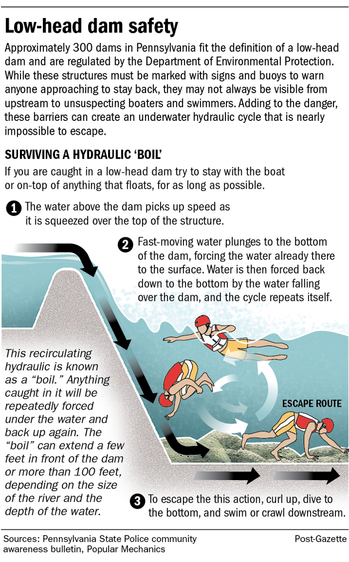
[edit]Even though the water around weirs can often appear relatively calm, they can be extremely dangerous places to boat, swim, or wade, as the circulation patterns on the downstream side—typically called a hydraulic jump—can submerge a person indefinitely. This phenomenon is so well known to canoeists, kayakers, and others who spend time on rivers that they even have a rueful name for weirs: "drowning machines".[10] The Ohio DNR recommends that a victim should "tuck the chin down, draw the knees up to the chest with arms wrapped around them. Hopefully, conditions will be such that the current will push the victim along the bed of the river until swept beyond the boil line and released by the hydraulic."[11] The Pennsylvania State Police also recommends to victims, "curl up, dive to the bottom, and swim or crawl downstream".[12] As the hydraulic jump entrains air, the buoyancy of the water between the dam and boil line will be reduced by upward of 30%, and if a victim is unable to float, escape at the base of the dam may be the only option for survival.
Common types
[edit]There are many different types of weirs and they can vary from a simple stone structure that is barely noticeable, to elaborate and very large structures that require extensive management and maintenance.
-

-
 Two weirs on the River Wear in Durham, UK: the lower weir is a compound weir that also has fish ladders to allow fish such as salmon to navigate the weir
 -
 The weir at Hambleden Lock on the River Thames at Hambleden, Buckinghamshire. A broad-crest weir, the public has right of way to cross the river using its walkway.
 -
 A manually operated needle dam-type weir near Revin on the River Meuse, France
 -
 A broad-crest weir in Warkworth, New Zealand
 -
 A complicated series of broad-crest and V-notch weirs at Dobbs Weir in Hertfordshire, UK


Broad-crested
[edit]A broad-crested weir is a flat-crested structure, where the water passes over a crest that covers much or all of the channel width. This is one of the most common types of weir found worldwide.[citation needed]
Compound
[edit]A compound weir is any weir that comprises several different designs into one structure. They are commonly seen in locations where a river has multiple users who may need to bypass the structure. A common design would be one where a weir is broad-crested for much of its length, but has a section where the weir stops or is 'open' so that small boats and fish can traverse the structure.
V-notch
[edit]A notch weir is any weir where the physical barrier is significantly higher than the water level except for a specific notch (often V-shaped) cut into the panel. At times of normal flow all the water must pass through the notch, simplifying flow volume calculations, and at times of flood the water level can rise and submerge the weir without any alterations made to the structure.
Polynomial
[edit]A polynomial weir is a weir that has a geometry defined by a polynomial equation of any order n.[13] In practice, most weirs are low-order polynomial weirs. The standard rectangular weir is, for example, a polynomial weir of order zero. The triangular (V-notch) and trapezoidal weirs are of order one. High-order polynomial weirs are providing wider range of Head-Discharge relationships, and hence better control of the flow at outlets of lakes, ponds, and reservoirs.
See also
[edit]References
[edit]Citations
[edit]- ^ "the definition of weir". Dictionary.com. Archived from the original on 2017-03-04. Retrieved 2017-03-03.
- ^ "Weir". www.etymonline.com. Online Etymology Dictionary. Archived from the original on 19 March 2017. Retrieved 20 May 2017.
- ^ Arif, Muhammad (2019). Power Generation Technologies: An Introduction. Islamabad, Pakistan: Pakistan Institute of Engineering and Applied Sciences (PIEAS). p. 117. ISBN 978-969-7583-01-0.
- ^ Arif, Muhammad (2019). Power Generation Technologies: An Introduction. Pakistan Institute of Engineering and Applied Sciences (PIEAS). p. 118. ISBN 978-969-7583-01-0.
- ^ "Weirs – Flow Rate Measure". www.engineeringtoolbox.com. Archived from the original on 2017-03-04. Retrieved 2017-03-03.
- ^ "Factors affecting weir flow measurement accuracy". openchannelflow.com. Archived from the original on 30 July 2016. Retrieved 2 May 2018.
- ^ Shen 1981, p. B31, Equ 6.
- ^ Tummers et al. 2016, pp. 183–194.
- ^ Silva et al. 2017, pp. 291–302.
- ^ Michael Robinson; Robert Houghtalen. "Dangerous dams". Rhode Island Canoe/Kayak Association. Rhode Island. Archived from the original on 2010-08-12. Retrieved 2011-06-26.
- ^ Ohio DNR Division of Parks and Watercraft Boating. "Lowhead Dam Safety". watercraft.ohiodnr.gov. Archived from the original on 30 November 2016. Retrieved 2 May 2018.
- ^ "Archived copy". Archived from the original on 2018-05-02. Retrieved 2017-06-15.
{{cite web}}: CS1 maint: archived copy as title (link) Escaping a low-head dam - ^ Baddour 2008, pp. 260–262.
Works cited
[edit]- Akers, Peter (1978). Weirs and Flumes for Flow Measurement. Wiley. ISBN 978-0471996378.
- Baddour, Raouf E. (2008). "Head-Discharge Equation for Sharp-Crested Polynomial Weir". Journal of Irrigation and Drainage Engineering. 134 (2): 260–262. Bibcode:2008JIDE..134..260B. doi:10.1061/(ASCE)0733-9437(2008)134:2(260). ISSN 0733-9437.
- Clemmens, Albert (2010). Water Measurement with Flumes and Weirs. Water Resources Publications, LLC. ISBN 978-1887201544.
- Shen, John (1981). Discharge Characteristics of Triangular-notch Thin-plate Weirs (PDF). Washington: United States Government Printing Office.
- Silva, Sergio; Lowry, Maran; Macaya-Solis, Consuelo; Byatt, Barry; Lucas, Martyn C. (2017). "Can navigation locks be used to help migratory fishes with poor swimming performance pass tidal barrages? A test with lampreys". Ecological Engineering. 102: 291–302. Bibcode:2017EcEng.102..291S. doi:10.1016/j.ecoleng.2017.02.027. ISSN 0925-8574.
- Tummers, Jeroen S.; Winter, Emily; Silva, Sergio; O’Brien, Pat; Jang, Min-Ho; Lucas, Martyn C. (2016). "Evaluating the effectiveness of a Larinier super active baffle fish pass for European river lamprey Lampetra fluviatilis before and after modification with wall-mounted studded tiles". Ecological Engineering. 91: 183–194. Bibcode:2016EcEng..91..183T. doi:10.1016/j.ecoleng.2016.02.046. ISSN 0925-8574.
Further reading
[edit]- Chanson, H. (2004). The Hydraulics of Open Channel Flow: An Introduction (2nd ed.). Oxford: Butterworth-Heinemann. ISBN 978-0-7506-5978-9.
- Chanson, Hubert (2007). "Hydraulic Performances of Minimum Energy Loss Culverts in Australia" (PDF). Journal of Performance of Constructed Facilities. 21 (4): 264–272. doi:10.1061/(ASCE)0887-3828(2007)21:4(264). ISSN 0887-3828.
- Gonzalez, Carlos A.; Chanson, Hubert (2007). "Experimental measurements of velocity and pressure distributions on a large broad-crested weir" (PDF). Flow Measurement and Instrumentation. 18 (3–4): 107–113. Bibcode:2007FloMI..18..107G. doi:10.1016/j.flowmeasinst.2007.05.005. ISSN 0955-5986.
- Henderson, F.M. (1996), Open Channel Flow, New York: MacMillan Company
- McKay, G.R. (1971). "Design of Minimum Energy Culverts." Research Report, Dept of Civil Eng., Univ. of Queensland, Brisbane, Australia, 29 pages & 7 plates.
- Sturm, Terry W. (2010). Open Channel Hydraulics. McGraw-Hill. ISBN 978-0-07-126793-9.
External links
[edit]- Hydraulics of Minimum Energy Loss (MEL) culverts and bridge waterways (Click "proceed" at the UQ-ITS Advisory webapge)
| International | |
|---|---|
| National | |
| Other | |
Etymology and History
Etymology
The term "weir" originates from Old English wer, denoting a dam or enclosure used to obstruct a stream, typically for raising water levels in contexts such as fishing or milling.[9] This word derives from the verb werian, meaning "to defend" or "to dam up," and traces back further to Proto-West Germanic *warjan and Proto-Germanic *warjaną, roots associated with guarding, protecting, or enclosing against water flow.[10][11] In other Germanic languages, cognates reflect similar concepts of barriers or defenses: for instance, Dutch weer (meaning weir or defense) and German Wehr (weir or dam), which share the same Proto-Germanic ancestry and influenced the English term through historical linguistic exchanges in medieval Europe.[12] These related terms highlight the word's evolution within a broader Indo-European family focused on containment and protection, though direct borrowings into Romance languages like French (where barrage is the modern equivalent for weir) did not occur, despite occasional conceptual overlaps with terms like gué for a ford.[13] By the Middle Ages, the meaning of "weir" had shifted in English usage from primarily denoting fish traps—simple enclosures to capture aquatic life in early historical applications—to more engineered structures for controlling water flow in rivers and streams.[9] This semantic broadening aligned with growing hydraulic needs in agriculture and industry, solidifying its role in technical vocabulary by the 12th century.[10]Historical Development
The earliest known uses of weirs date back to ancient Mesopotamia around 3000 BCE, where they served as diversion structures in irrigation systems along the Tigris and Euphrates rivers. Sumerian engineers constructed low dams and weirs to control seasonal floods, directing water into canals that supported agriculture in the arid region; these innovations were crucial for the development of urban centers like Uruk.[14] In contemporary ancient Egypt, similar weir-like barriers along the Nile facilitated basin irrigation by retaining floodwaters, enabling the cultivation of crops such as wheat and barley that underpinned the Old Kingdom's economy.[15] Additionally, rudimentary weirs functioned as fish traps in both regions, channeling river flows to capture migratory species like carp and tilapia, supplementing diets in riverine communities.[16] During the medieval period in Europe, weirs evolved into more sophisticated tidal structures, particularly in England, where they supported both fishing and milling. By the 12th century, tidal weirs on the River Thames, such as those near London, utilized wattle and timber constructions to impound water during high tides, creating pools for trapping salmon and eels while powering early grain mills.[17] These installations proliferated along navigable rivers, but their proliferation led to navigational conflicts, culminating in Clause 33 of Magna Carta in 1215, which mandated the removal of obstructive weirs to improve river access.[18] The 18th and 19th centuries marked significant advancements in weir design, driven by the Industrial Revolution's demand for reliable water power in the UK and US. British engineer James Brindley pioneered canal systems like the Bridgewater Canal, completed in 1761, incorporating weirs to optimize flow for mills and transport.[19] In the United States, 19th-century canal expansions, including the Erie Canal completed in 1825, featured engineered weirs to manage water levels and prevent flooding, facilitating inland trade and industrial growth.[20] The transition to modern concrete weirs occurred in the early 20th century, reflecting advances in materials and large-scale engineering. The U.S. Bureau of Reclamation's construction of concrete overflow structures, such as those at Roosevelt Dam in 1911, introduced durable, mass-concrete designs that replaced vulnerable timber weirs, enabling better flood control and irrigation in arid western states.[21] This shift emphasized hydraulic stability and longevity, setting the foundation for contemporary weir applications.[22]Basic Principles and Design
Fundamental Function
A weir is defined as a low dam or barrier constructed across a watercourse to raise the upstream water level or divert flow into channels such as irrigation canals or measurement devices.[23] This structure operates primarily as an overflow device, where excess water spills over its crest to maintain controlled depths upstream while allowing passage downstream.[24] The basic mechanics of a weir involve water flowing over the crest, generating a hydraulic head—the vertical difference between upstream and downstream water surfaces—that governs the rate of discharge and prevents excessive ponding without significant water retention.[25] This overflow process ensures efficient flow regulation in rivers, streams, or channels by balancing incoming and outgoing volumes, typically under low-head conditions where the structure height is limited to a few meters.[26] Key components of a weir include the crest, the elevated top edge over which water flows; the apron, a sloped or level downstream base designed to dissipate kinetic energy and prevent scour; and wing walls, which extend from the sides to stabilize the structure, protect embankments, and guide flow.[27] These elements work together to ensure structural integrity and hydraulic efficiency. Unlike high-head impoundment dams, which create large reservoirs for storage and flood control, weirs function as overflow structures with minimal upstream storage, focusing on immediate flow diversion and level adjustment rather than long-term water retention.[26]Hydraulic Principles
The hydraulic principles governing flow over a weir are rooted in the conservation of energy, as described by Bernoulli's equation, which relates the total mechanical energy along a streamline in steady, incompressible flow. Upstream of the weir, where the flow velocity is typically low, the energy is primarily potential, consisting of the pressure head and elevation head relative to the weir crest. As water approaches the crest, the streamlines contract, accelerating the flow and converting potential energy into kinetic energy, with the pressure at the crest surface approximating atmospheric due to the free surface. This results in a velocity at the crest approximately equal to , where is the head above the crest and is gravitational acceleration, though actual velocity is reduced by viscous effects and flow contraction.[28][29] The standard discharge equation for a rectangular weir derives from integrating the velocity profile over the nappe (the falling sheet of water) using this energy conservation. For a weir of length (width perpendicular to flow), the theoretical discharge is , but empirical adjustments account for end contractions and friction, yielding the practical form , where is the discharge coefficient (typically 1.70 to 1.84 for sharp-crested weirs in SI units (m³/s and m), varying with head and geometry). This equation assumes unsubmerged flow, free discharge, and negligible approach velocity.[29][28] Several factors influence the accuracy of weir flow computations. The shape of the weir crest—sharp-edged versus rounded—affects the discharge coefficient by altering contraction and energy losses; sharp crests minimize adhesion and promote cleaner separation of the nappe. Approach velocity, if significant (e.g., in steep channels), increases the effective head and requires correction terms in the equation to avoid underestimation of discharge. Submergence significantly affects discharge when the downstream water level rises above about 67-70% of the head above the crest (submergence ratio of 0.67-0.70), with slight effects starting at ~10%, reducing flow by backpressure on the nappe and necessitating modular flow limits or separate submerged equations.[29][28] At the weir crest, the flow typically reaches critical conditions, where the Froude number , with as mean velocity and as flow depth. This critical state represents the minimum specific energy for a given discharge, balancing inertial and gravitational forces, and occurs because the weir imposes a control section that accelerates subcritical upstream flow to critical at the crest before transitioning to supercritical in the nappe. For broad-crested weirs, this condition is more precisely achieved over the flat crest, enabling direct measurement of critical depth.[30][28]Flow Measurement Techniques
Weirs serve as primary devices for stream gauging in hydrology and hydraulic engineering, enabling the precise quantification of water discharge by creating a controlled overflow condition that correlates flow rate with measurable water head.[31] This method is particularly effective in open channels where direct velocity-area measurements are impractical, such as in small streams or irrigation systems.[29] Head over the weir, defined as the vertical distance from the weir crest to the upstream water surface, is typically measured using staff gauges or automated sensors to ensure accurate discharge estimation. Staff gauges, consisting of graduated scales affixed to stable structures upstream of the weir, allow manual readings with an accuracy of ±0.01 foot or better under calm conditions.[32] For continuous monitoring, sensors such as pressure transducers, ultrasonic level detectors, or radar devices are installed in stilling wells to record head variations at intervals like every 15 minutes, minimizing human error and enabling real-time data collection.[33] Discharge is computed by applying calibration curves or rating tables derived from empirical data, which relate measured head to flow rate under specific weir geometries. These calibrations account for factors like approach velocity and are developed through volumetric tests or current-meter comparisons to establish reliable relationships.[1] The United States Geological Survey (USGS) provides standardized guidelines for thin-plate weirs, including specifications for rectangular and triangular notches, ensuring consistency and accuracy across installations with typical errors below 5 percent when properly calibrated.[34] Weirs offer high accuracy for measuring low flows, often achieving precision within 2-3 percent, making them ideal for applications requiring detailed low-discharge records, such as environmental monitoring or water rights allocation.[29] Their simplicity and low cost further enhance their utility in remote or resource-limited settings.[35] However, weirs are sensitive to debris accumulation, which can obstruct the crest or alter the head measurement, necessitating regular maintenance to preserve accuracy.[36] Submergence occurs when downstream water levels rise, suppressing the nappe and invalidating free-flow assumptions, which limits their use in variable tailwater conditions. Proper installation requires free-flow conditions to maintain aeration beneath the overflowing nappe, preventing vacuum effects that distort measurements. A sufficient upstream pool must be established, with head measured at least three to five times the maximum anticipated head distance from the weir to avoid velocity-of-approach errors. Downstream, the channel should provide adequate drop and ventilation to ensure the nappe remains fully aerated, typically requiring a tailwater level at least 0.2 feet (0.06 m) below the crest elevation to ensure full aeration of the nappe.[29] The approach channel should be straight and uniform for at least 10-20 times the maximum head width to minimize turbulence.[35]Applications
Flood Control and River Management
Weirs contribute to flood control by facilitating the temporary storage of peak flows in upstream areas, which attenuates flood peaks and mitigates downstream inundation risks. This mechanism relies on the weir raising the upstream water level, allowing floodwaters to spread across adjacent floodplains or bypass channels rather than surging through the main river channel.[37] In practice, passive overflow weirs activate during high flows, diverting excess water into designated storage or relief areas to reduce peak discharge volumes.[37] A prominent example of this application is found in the Sacramento River flood control system managed by the California Department of Water Resources, where structures like the Fremont Weir and Sacramento Weir have operated for over a century to protect urban areas. The Fremont Weir, constructed in 1924, diverts flows into the Yolo Bypass—capable of handling up to 80% of floodwaters—when river stages exceed its crest, as occurred during an atmospheric river event in February 2024. Similarly, the Sacramento Weir, operational since 1916, employs gated controls for precise diversion, with expansions underway to enhance capacity amid increasing flood threats.[37] In the United Kingdom, the Environment Agency deploys weirs in lowland river systems to achieve comparable attenuation, often integrating them into broader floodplain management strategies to store and slowly release waters during events.[38] Beyond flood attenuation, weirs support river training by stabilizing banks, controlling sedimentation, and preserving navigable depths, thereby enhancing overall channel morphology and infrastructure longevity. By slowing upstream velocities, weirs promote sediment deposition in controlled zones, preventing excessive scour and bank erosion while maintaining sufficient water depths for navigation in rivers and connected canal networks.[39] For instance, the U.S. Army Corps of Engineers utilizes bendway weirs on the Mississippi River—submerged rock structures angled from outer bends—to redirect flows away from vulnerable banks, reduce meander migration, and minimize sedimentation that could shallow navigation channels. These installations, such as those at Dogtooth Bend, have demonstrated effectiveness in stabilizing reaches prone to erosion without disrupting overall river conveyance.[39] In UK lowland contexts, Environment Agency weirs similarly regulate flow to mitigate downstream bank erosion, although they can lead to upstream sediment deposition that requires management.[40] Weirs are also essential in irrigation systems, where they control water levels in canals and divert flows into distribution networks for agricultural use. Sharp-crested or broad-crested weirs are commonly installed to measure and regulate discharge, ensuring equitable water allocation while preventing overtopping or sedimentation issues in low-gradient channels. The U.S. Bureau of Reclamation employs standardized weir designs in major irrigation projects to maintain precise upstream pond levels and facilitate automated flow control.[41] Weirs are frequently integrated with spillways in comprehensive flood management systems, where the weir crest serves as the overflow pathway for controlled water release during extreme events, preventing uncontrolled overtopping of embankments or dams. This combination allows operators to modulate discharges based on downstream conditions, optimizing flood routing while adhering to basic hydraulic principles of overtopping flow. Principal and emergency spillways often incorporate weir elements to handle design floods, ensuring structural integrity and reducing breach risks.[42]Power Generation and Watermills
Weirs have played a crucial role in historical water power generation by creating the necessary hydraulic head to drive watermills, which were essential for grinding grain and other mechanical tasks in medieval societies. In England, the Domesday Book of 1086 records over 5,000 watermills, many of which relied on weirs to impound water and elevate it for delivery to the mill wheels.[43] These structures diverted river flow into millponds, producing a consistent head of water that powered vertical wheels of varying designs. Undershot wheels, where water flows beneath the wheel and pushes the paddles, required minimal head (typically 1-2 meters) and were suited to low-gradient sites near weirs.[44] Overshot wheels, fed from above via channels from the weir pond, achieved higher efficiency (up to 70%) with heads of 3-10 meters by allowing water to descend fully onto the wheel buckets.[45] Breastshot wheels, an intermediate type, received water at mid-wheel height for heads of 2-4 meters, balancing efficiency and simplicity in weir-fed systems.[46] In modern applications, weirs enable low-head hydropower in run-of-river plants, where water is diverted over or through the structure to turbines without large storage reservoirs. These setups typically operate with heads under 10 meters, integrating Kaplan turbines—adjustable-blade propellers optimized for variable flows and low heads—to capture energy efficiently.[47] The theoretical power output from such systems is given by the formula where is water density (approximately 1000 kg/m³), is gravitational acceleration (9.81 m/s²), is volumetric flow rate (m³/s), is the net head (m), and is overall efficiency (often 80-90% for Kaplan turbines).[48] This configuration allows continuous generation aligned with natural river flows, powering remote communities or supplementing grids. A representative case is the Hagestein hydropower plant in the Netherlands, integrated with a historic weir on the Nederrijn River, which generates 1.8 MW to serve approximately 1,500 households annually.[49] Similarly, small-scale facilities along the Rhine River, such as those at older barrages, contribute up to 10 MW per site in run-of-river mode, supporting regional renewable targets with minimal infrastructure.[50] Compared to reservoir-based dams, weir-integrated run-of-river systems offer advantages like reduced land flooding—often limited to small pondage areas—and lower ecological disruption, as they avoid extensive submersion of valleys and associated habitat loss.[51]Environmental and Invasive Species Control
Weirs serve as selective barriers in ecosystem management to control the spread of invasive aquatic species, particularly by blocking upstream migration while allowing passage for native species. In the Great Lakes region, electric weirs have been employed since the mid-20th century to impede adult sea lamprey (Petromyzon marinus) spawning runs, with experimental installations beginning in the 1950s and expanded use in the 1960s as part of integrated pest management programs.[52] These devices generate pulsed electric fields across the water column to stun or deter lampreys without significantly harming non-target fish like salmonids, achieving partial blockage rates of up to 90% in some tributaries when combined with traps.[53] Mechanical weirs with integrated traps further enhance selectivity by funneling invasives into capture points, contributing to a 90% reduction in sea lamprey populations since the program's inception.[54] Weirs also facilitate habitat creation by impounding water to form pools that support wetland ecosystems and aquatic biodiversity. Porous or low-head weirs, constructed from natural materials like boulders, maintain stable pool depths for fish rearing and invertebrate communities, while promoting sediment sorting to enhance substrate diversity.[55] Specialized designs incorporate baffles or stepped structures to increase water turbulence, thereby improving dissolved oxygen levels essential for aerobic aquatic life in low-flow conditions.[56] These features have been applied in restoration efforts to rehabilitate degraded streams, fostering wetland vegetation and supporting species like amphibians and macroinvertebrates. In river restoration projects, nature-like weirs such as rock ramps are implemented to enhance biodiversity while complying with regulatory frameworks like the EU Water Framework Directive (WFD). These ramps, built with graded rock and boulders to mimic natural riffles, facilitate fish passage for migratory species and create heterogeneous habitats that boost overall ecological status.[57] Under the WFD, such installations in European rivers have improved hydromorphological quality and native fish assemblages, with studies showing increased upstream migration success rates of 70-100% for potamodromous species like brown trout. By restoring connectivity without permanent fragmentation, rock ramp weirs support WFD goals of achieving good ecological potential in modified water bodies.[58] Weir-integrated traps enable effective monitoring of invasive species spread by capturing individuals for identification, population estimation, and early detection. Resistance board weirs with attached traps have demonstrated high efficacy, capturing up to 75% of targeted invasives like sea lamprey in portable setups, allowing for data collection on migration timing and abundance without broad ecosystem disruption.[59] In European contexts, picket and wire mesh traps at weirs have removed thousands of invasive fish annually, providing quantitative insights into dispersal patterns and informing adaptive management strategies.[60] These methods outperform some molecular techniques in detection probability for certain species, ensuring timely interventions to prevent establishment.[61]Types of Weirs
Sharp-Crested Weirs
Sharp-crested weirs feature a thin upstream edge on the crest, typically constructed from sheet metal or precast concrete with a thickness of 1 to 2 mm, to ensure the flowing nappe detaches cleanly from the crest without adhesion. This sharp edge promotes free discharge conditions by allowing air to vent freely beneath the nappe, preventing vacuum formation and maintaining accurate flow measurement.[62] The design minimizes surface tension effects that could cause the water sheet to cling to the downstream face, which is critical for reliable operation under varying flow rates.[1] A prominent variant is the V-notch sharp-crested weir, which incorporates a triangular notch—commonly with a 90-degree angle—for enhanced accuracy in measuring low flows, as the narrowing geometry produces measurable heads even at small discharges. The theoretical discharge through a V-notch weir is expressed as where is the volumetric flow rate, is the discharge coefficient (typically 0.58 to 0.62), is the acceleration due to gravity, is the notch angle, and is the head measured above the notch vertex. This configuration excels in applications requiring sensitivity to subtle flow changes, such as irrigation canals with intermittent low-volume releases.[41] These weirs are widely employed in laboratory flumes for controlled hydraulic experiments and in field gauging stations for monitoring stream and channel flows, offering precision levels of ±2% under optimal conditions.[63] Their primary advantages include straightforward construction, cost-effectiveness, and high measurement accuracy across a broad range of subcritical flows, particularly for the V-notch in low-discharge scenarios.[64] However, they are susceptible to damage from debris or sediment buildup, which can dull the crest edge and degrade performance, and require careful site preparation to avoid upstream disturbances that affect head readings.[65] Installation of sharp-crested weirs occurs in either suppressed or contracted configurations to suit channel dimensions and flow dynamics. Suppressed weirs extend across the entire channel width, eliminating end contractions and simplifying setup in narrow or uniform channels, though they necessitate ventilation provisions—such as downstream pipes—to ensure air access under the nappe.[65] In contrast, contracted weirs feature a narrower crest than the channel, inducing side contractions that enhance flow convergence but demand greater upstream length (at least 15 times the head) for velocity stabilization. Both types require the crest to be level and perpendicular to the flow, with the plate secured firmly to prevent leakage.[66]Broad-Crested Weirs
Broad-crested weirs are hydraulic structures featuring a wide, flat crest that facilitates the establishment of critical flow conditions, characterized by a Froude number (Fr) of 1 over the crest. This design allows streamlines to become parallel to the crest, resulting in hydrostatic pressure distribution and enabling reliable flow measurement independent of downstream conditions.[67][68] To achieve these conditions, the crest width is typically set to 2 to 5 times the anticipated water depth upstream, ensuring sufficient length for the flow to accelerate to critical depth without significant interference from approach or end effects.[69] The discharge over such a weir is given by the equation where is the discharge coefficient (theoretically approximately 0.544 for ideal frictionless conditions), is the crest length, is the specific energy head above the crest, and is the acceleration due to gravity.[70] This formulation derives from the principles of critical flow in open channels, providing a direct relationship between measurable head and flow rate.[68] Broad-crested weirs are advantageous for their durability under high flows, lower sensitivity to minor errors in head measurement, and ability to pass sediment and floating debris more effectively than thinner designs, making them ideal for applications in irrigation canals.[41][69] However, they demand precise construction and leveling of the crest to maintain horizontality; inaccuracies can disrupt critical flow and reduce measurement accuracy.Compound and Specialized Weirs
Compound weirs integrate multiple crest configurations at varying heights to accommodate a broad spectrum of flow rates, enabling accurate measurement and control across low to high discharges. A typical design combines a rectangular crest for higher flows with a V-notch for lower flows, allowing modular operation where the V-notch handles small discharges until the head rises to engage the rectangular section. This hybrid approach minimizes sensitivity to head variations and extends the measurable flow range by up to two orders of magnitude compared to single-crest weirs. For instance, a compound sharp-crested weir with two triangular notches of different angles (e.g., 90° and 53.13°) has been calibrated to achieve discharge errors below 2% over a wide head range.[71] Polynomial weirs feature curved crests shaped according to a polynomial profile, engineered to establish a linear relationship between water head and discharge, which simplifies flow computation and reduces calibration errors in varying conditions. Unlike standard weirs where discharge is nonlinear with head, the polynomial form ensures constant discharge coefficient across the operational range, improving accuracy for applications requiring precise volumetric control. The crest equation is derived to pass a specified maximum flow at maximum head while maintaining linearity from zero head, with experimental validations showing head-discharge errors under 1%. Labyrinth and piano key weirs employ folded or modular geometries to maximize effective crest length within constrained widths, significantly enhancing discharge capacity without increasing head or structure footprint. Labyrinth weirs zigzag in plan view, effectively lengthening the crest by factors of 2 to 4, which boosts unit discharge by 2-4 times relative to linear weirs at the same head, ideal for spillways with space limitations. Piano key weirs extend this concept with cantilevered keys resembling piano keys, further optimizing flow through overhangs that reduce nappe interference and increase efficiency by up to 20% over labyrinth designs in low-head scenarios. These structures have been applied in reservoir spillways, such as the Goulours Dam in Réunion Island, to handle flood discharges.[72][73][74][75] Selection criteria for compound and specialized weirs emphasize sites with highly variable flows, such as urban streams subject to stormwater surges and baseflows, where standard weirs fail due to head sensitivity or submergence risks. These designs are preferred when space is limited and capacity must be amplified without elevating crests, prioritizing geometries that maintain efficiency across flow regimes while minimizing head loss. In regions like French Polynesia, modular piano key variants have been adapted for coastal reservoirs to manage tidal-influenced variable discharges, demonstrating resilience in tropical hydraulic conditions.[76][77]Environmental and Safety Issues
Ecological Impacts
Weirs trap sediment in the impounded area upstream, significantly reducing the natural supply of sand, gravel, and finer particles to downstream reaches. This sediment deficit often leads to channel incision, where the riverbed erodes vertically, lowering water levels and altering hydraulic conditions that support diverse habitats such as riffles and pools essential for aquatic life. Over time, this degradation can result in the loss of spawning grounds and foraging areas, exacerbating habitat fragmentation in river ecosystems.[78][79] The creation of slower-moving, impounded waters behind weirs also degrades water quality by forming stagnant pools that encourage excessive algal growth due to trapped nutrients and organic matter. These conditions elevate water temperatures in summer months, which in turn reduces dissolved oxygen levels, stressing temperature-sensitive organisms and promoting hypoxic zones that limit aerobic respiration in aquatic communities. Such alterations disrupt the natural flow regime, shifting ecosystems from dynamic, oxygen-rich environments to more stable but degraded lentic systems.[80][78] Biodiversity in weir-impacted rivers undergoes notable shifts, with lotic (flow-dependent) species declining in favor of lentic (still-water adapted) taxa, leading to homogenized communities upstream and downstream. Long-term studies indicate substantial reductions in macroinvertebrate diversity, with unregulated reaches showing 38% higher taxa richness than regulated reaches, as flow alterations and habitat changes diminish suitable niches for sensitive invertebrates like mayflies and stoneflies. While weirs can incidentally benefit invasive species control by impeding upstream dispersal, their overall ecological footprint remains predominantly negative without intervention.[81][82] To mitigate these impacts, sediment bypass systems—such as tunnels or sluice gates—can be implemented to periodically release trapped material downstream, helping maintain natural sediment transport and reducing incision risks, though their effectiveness depends on site-specific hydrology and design. In recent years, weir removal has emerged as an effective mitigation strategy, with a record number of river barriers dismantled in Europe in 2024 to restore natural flow and habitats.[83]Fish Migration Barriers
Weirs impede upstream fish migration primarily through high water velocities over their crests, which exceed the swimming capabilities of many species, combined with turbulence that disorients and exhausts migrants. This mechanism particularly affects anadromous fish like salmon, which rely on precise navigation to reach spawning habitats, as the accelerated flow creates an energetic barrier that prevents effective ascent.[84][85][86] Such barriers can substantially reduce passage success, with studies on Atlantic salmon showing efficiencies ranging from 0% to 47% across years, effectively blocking up to nearly all upstream migrants in impacted rivers and contributing to historical population declines. For instance, low-head weirs have been linked to limited distribution and abundance of Atlantic salmon and other salmonids, exacerbating declines observed in North Atlantic rivers.[87][88] To mitigate these effects, various fish passage solutions have been developed, including fish ladders that provide stepwise pools for resting and ascending, fish lifts that transport fish vertically, and nature-like bypasses such as rock weirs with slopes around 1:10 to mimic natural riffles. In the United States, the Federal Energy Regulatory Commission (FERC) mandates the installation and maintenance of such upstream passage facilities at licensed hydropower projects to ensure safe migration, with requirements covering ladders, lifts, and bypasses.[89][90][91] Passage efficiency of these solutions is commonly assessed through telemetry studies, which track individual fish movements using radio or passive integrated transponder tags to measure attraction rates, entry success, and overall transit times at weirs. Meta-analyses of such telemetry data across multiple fishways indicate variable performance, with efficiencies often below 50% for some species, guiding design improvements.[92][93]Human Safety Concerns
Weirs pose significant hazards to human safety, particularly through drowning risks associated with their hydraulic features. The recirculating currents and hydraulic jumps formed downstream of low-head weirs, often referred to as "drowning machines," can trap swimmers, kayakers, and boaters in powerful undertows that prevent escape.[94] These currents arise from the submerged hydraulic jump, where water plunges over the crest and creates an upstream-directed flow combined with aeration that reduces buoyancy by up to 30%, making it difficult for victims to surface.[95] Additionally, weirs can function as strainers, where debris and human limbs become entangled against the structure, exacerbating entrapment.[96] In the United States, low-head dams and weirs are estimated to cause approximately 50 drowning fatalities annually, with over 1,000 documented deaths over the last several decades (as of 2022).[97][98] Maintenance activities at weirs introduce further dangers, including slip hazards and risks of structural failure. Workers clearing debris from the crest or upstream areas face slippery surfaces due to wet conditions and accumulated silt, increasing the likelihood of falls into turbulent waters.[99] Undermining from scour during high flows can lead to sudden structural collapses, endangering personnel on or near the weir.[100] To mitigate these risks, public safety measures such as warning signs, upstream booms, and fencing are recommended around weirs. Signs should be placed upstream and at approaches to alert users of hazards, with multiple placements on bends or obscured views for visibility.[99] Safety booms prevent vessels from approaching the crest, while fencing creates exclusion zones; in the UK, these align with Health and Safety Executive guidelines on risk assessment and safety signage under the Safety Signs and Signals Regulations 1996.[99][101] Climate change exacerbates these safety concerns by altering river regimes, with increased extreme flows from heavier rainfall and floods heightening the intensity of hydraulic jumps and recirculation at weirs.[102] Rising sea levels and intensified storm events further stress weir structures, potentially leading to more frequent undermining and overflow incidents that amplify drowning and maintenance risks.[37]References
- https://en.wiktionary.org/wiki/weir