Hubbry Logo
search
logo
718844

Adomi Bridge

logo
Community Hub0 Subscribers
Read side by side
from Wikipedia

The Adomi Bridge (originally the Volta Bridge) is a latticed steel arch suspension bridge crossing the Volta River at Atimpoku in Ghana in West Africa. It is the first permanent bridge to span the Volta River, which drains south into the Gulf of Guinea, and is Ghana's longest suspension bridge. It provides the main road passage, just south of the Akosombo Dam, between the Eastern Region and the Volta Region of Ghana. It was opened in 1957 by Kwame Nkrumah, Ghana's first president. The iconic crescent-shaped arch bridge is featured in Ghanaian stamps and currency.

Key Information

History

[edit]
Adomi Bridge under construction in 1957. The N2 in the background links Tema with the Volta Region

In 1953 (before the independence of Ghana in 1956 from British colonial rule), the decision was made to build a bridge across the Volta River to replace the overloaded ferry service at Senchi where delays were occasionally up to a few days. Reconnaissance indicated a good site for a single-span crossing about 800ft long at a narrow neck of the river at Adomi, about 2.5 miles upstream of the ferry and closer to the then-projected dam and power station in the Volta River Project. Several sketch designs for an arch bridge or a suspension bridge at Adomi and other sites were drawn and cost estimates were developed. The Standing Development Committee chose the single-span arch at Adomi.[1]

Plague commemorating 1957 opening by Kwame Nkrumah

In Fall 1953 the consulting engineers were appointed: Sir William Halcrow & Partners were the project administrators and designed all approach roads and spans, while Freeman Fox & Partners were to design the single-span arch bridge. A year later, tenders were invited for the complete project, including approach roads, the arch bridge and approach spans. By January 1955, the contracts were settled and some construction staff began to arrive on site. Dorman Long (Bridge and Engineering) Ltd was the main construction contractor and Cleveland Bridge & Engineering Company was the steelwork fabricator. Work on the bridge began in March 1955, with the steel parts being prefabricated in the United Kingdom, while concrete works for the approach spans and the bridge abutments were carried out on site. The prefabricated parts were fully welded, but almost all on-site steelwork erections were designed as bolted connections, including those of the upper and lower chord of the crescent-shaped arch. The concrete carriageway was built after the steelwork was completed for the arch and the deck. By January 1957 the project was substantially completed. The total cost of the completed project was 682 thousand British pounds.[1]

Design of arch bridge

[edit]
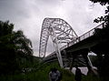
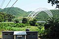
Adomi Bridge steel arch supporting two-lane roadway

The single-span arch bridge was designed by William Brown of the engineers' Freeman Fox & Partners. It is a two-hinged silver latticed steel crescent-shaped arch bridge with a two-lane road deck suspended by cables.[2] The lower-chord arch rises 158.5 ft (48.3 m) above the hinges and the main span is 805 ft (245 m) long. To make an aesthetically pleasing crescent-shaped arch, the lower curve formed by the lower chords is a parabola, and the upper curve is derived from it by offsets decreasing logarithmically from the center to the hinges.[1]

Aesthetically the arch was the perfect complement to the trough of the valley... and the silver colour proposed for the steelwork would offset the green of the hills against which it would be seen. --Scott and Roberts (1958)[1]

As the roadbed is suspended by means of vertical cable stays (hangers) connected to the steel truss arch, the bridge can be considered as a hybrid arch suspension type.[3] Pairs of vertical cables or hangers are attached at 35-ft intervals to the deck transverse beams, which, along with six longitudinal stringer beams and bracers in between the transverse beams, support the weight of the roadway and its load.[1][4]

The bridge was officially opened on 25 January 1957 by Kwame Nkrumah, then Prime Minister of the Gold Coast and first President of Ghana.[5] It carries the National Route N2 and has been of tremendous help to travelers and traders who use the road to access the east and north regions of Ghana.

Route to the bridge

[edit]

The Adomi Bridge is located in Atimpoku in the Eastern Region of Ghana, which is along the Volta River. The bridge carries National Route N2 and connects parts of the Eastern Region and Juapong in the North Tongu District, Ho, Hohoe, and other towns in the Volta Region. A trip from the northern regions of Ghana on N2 would go through the eastern corridor and finally use the Adomi Bridge to cross the Volta River. The bridge is about 87 km (54 mi) northeast of Accra, the capital of Ghana, and about 75 km (47 mi) north of the port of Tema.[6]

Rehabilitation works

[edit]
  • 2008: Some serious cracks, possibly due to fatigue fracture, on the bridge deck's traverse beam at mid-span were discovered.[4] Following these findings, the Government of Ghana imposed a load limit on the bridge to slow down the damage rate. The cracked girders were locally strengthened by the installation of additional steel plates at the affected areas. The continued use of the bridge by overloaded trucks however, further compromised the deck's safety and stability.[7]
  • 2009: More cracks developed, mainly around the same area as the earlier ones were discovered; this necessitated major rehabilitation works on the suspension bridge deck.[8]
  • 2011: A full bridge inspection was completed in April 2011. Overall, the arch was found to be in good condition, but the bridge deck was structurally much worse than expected, which was attributed to high traffic loads and lack of maintenance, and should be replaced.[7]
  • 2014: The bridge was closed to traffic on 10 March 2014 for the replacement of the entire suspended road deck and all hangers, by engineers of Bilfinger MCE GmbH of Austria for 13 million euros.[9][10] The old concrete deck was replaced by a lighter, stronger orthotropic deck with a double spine: a steel plate with two continuous longitudinal girders, running under roadway/walkway curbs, along the entire suspended span.[7]
  • 2015: Newly rehabilitated bridge opened to traffic in December 2015.[11]

Tourist Site

[edit]

In April 2019, Adomi Bridge was classified as a tourist site after a consensus between the Asuogyaman District, Ghana Highway Authority and Ghana Tourism Development Company (GTDC).[12]

[edit]

References

[edit]
[edit]
Revisions and contributorsEdit on WikipediaRead on Wikipedia
from Grokipedia
The Adomi Bridge is a latticed steel arch suspension bridge that spans the Volta River at Atimpoku in Ghana's Eastern Region, serving as the primary road connection between the Greater Accra Region and the Volta Region.[1][2] Constructed during the mid-1950s and opened to traffic on January 25, 1957, it replaced a unreliable ferry service and marked Ghana's first major engineering project financed independently following colonial rule.[1][3] The bridge's construction began in 1955 under the direction of consulting engineers Sir William Halcrow & Partners and Freeman Fox & Partners, with key design contributions from engineers Bill Brown and Colin Blackwell.[3] Primary contractors included Dorman Long and Cleveland Bridge, who utilized manganese steel for the structure to ensure durability in the tropical environment.[3] The project was commissioned during the transition to Ghanaian independence, with President Kwame Nkrumah overseeing its dedication as a symbol of national progress.[1] Featuring a distinctive crescent-shaped arch with a 245-meter clear span and a 67-meter rise, the two-hinged design includes a suspended deck supported by steel cables spaced at 10.7-meter intervals, flanked by three approach spans of 15 meters each on both sides, for a total length of 334 meters.[1][3][4] As Ghana's only suspension bridge of its kind, it holds cultural significance, appearing on national stamps and currency, and remains a critical artery for commerce and tourism along the N6 highway near the Akosombo Dam.[2][1] Due to corrosion and structural wear over decades of heavy use, the bridge underwent major rehabilitation starting in 2012, led by Bilfinger MCE GmbH, which involved replacing the deck, hangers, and corrosion protection systems; the work concluded in November 2015, restoring full functionality.[1] Ongoing maintenance efforts, including additional services and approach road upgrades budgeted through 2025, underscore its enduring role in Ghana's infrastructure.[5][6]

Location and Route

Geographical Position

The Adomi Bridge spans the Volta River, connecting the town of Atimpoku in Ghana's Eastern Region on the western bank to Adome in the Volta Region on the eastern bank.[7] This positioning makes it a key crossing point in the southeastern part of the country, facilitating regional connectivity across the river's lower reaches.[8] Geographically, the bridge is situated approximately 88 kilometers northeast of Accra, Ghana's capital, and roughly 9 kilometers downstream from the Akosombo Dam.[9][7] Its precise coordinates are 6°14′22″N 0°05′44″E, placing it within the tropical monsoon climate zone (Köppen Am) characterized by high humidity, seasonal rainfall, and lush vegetation along the riverbanks.[10] The environmental context of the Adomi Bridge encompasses the dynamic lower Volta River ecosystem, which supports diverse aquatic and riparian habitats but is vulnerable to flooding from heavy monsoon rains and periodic spills from the upstream Akosombo Dam.[11] These flood events, occurring primarily between July and October, can alter water levels significantly, impacting local biodiversity such as fish populations and bird species that rely on the river's floodplains, while also posing risks to nearby agricultural lands and settlements.[12] The tropical setting further influences ecological processes, including nutrient cycling in the riverine wetlands that sustain the region's fisheries and vegetation.[13]

Transportation Role

The Adomi Bridge forms a critical component of Ghana's road infrastructure by carrying National Route N2, also known as the Tema-Jasikan highway, which serves as the primary arterial link connecting the Eastern Region to the Volta Region.[14] This route integrates the bridge into the broader Eastern Corridor network, enabling seamless vehicular movement across the Volta River and supporting the flow of goods and passengers between southern coastal areas and inland destinations.[15] As the first permanent crossing over the Volta River, the bridge replaced overloaded ferry operations at Senchi, eliminating delays that previously hindered regional mobility and establishing a reliable alternative for cross-river transit.[16] It now facilitates essential trade, daily travel, and northward access toward Ghana's interior, including routes leading to northern economic hubs, thereby reducing logistical bottlenecks for commuters and commercial operators.[17] Following its 2014-2015 rehabilitation, the bridge's two-lane configuration supports a diverse range of traffic, including private vehicles, commercial trucks, and pedestrians, while accommodating limited heavy loads up to enhanced weight thresholds to prevent structural strain.[1] This upgraded capacity has been vital during peak periods, handling an estimated 30,000 vehicles daily as of 2020, which underscores its role in maintaining continuous connectivity when alternative routes are unavailable.[18] A new Volivo Bridge is under construction as of 2025 to provide an alternative crossing and alleviate traffic on the Adomi Bridge.[19] The bridge's logistical significance extends to bolstering economic activities in the Volta Basin, where it enhances transport links for agricultural produce, freshwater fishing yields, and local commerce, fostering integration between riverine communities and national markets.[20] By bridging the Eastern and Volta Regions just south of the Akosombo Dam, it ensures efficient access to key infrastructure while promoting sustained regional development.[21]

History

Planning and Construction

In 1953, during the British colonial administration of the Gold Coast (now Ghana), the decision was made to construct a bridge across the Volta River to replace the unreliable Senchi ferry service, which had become inadequate for the growing traffic volume between the Eastern and Volta regions.[1] The site at Adomi was selected for its favorable geological conditions, cost-effectiveness, and construction timeline, as a single-span arch bridge would minimize foundation challenges in the river's variable flow.[1] This initiative marked one of the first major infrastructure projects financed primarily by local colonial government funds, addressing the pressing need for reliable connectivity in the post-World War II era.[22] The design was overseen by the British consulting firm Sir William Halcrow & Partners, with the detailed engineering led by Freeman Fox & Partners, including key contributions from Bill Brown and Colin Blackwell.[3] Construction began in March 1955, with steel components prefabricated in the United Kingdom and assembled on-site using a cantilever method for the arch.[22] The main contractor was Dorman Long (Bridge and Engineering) Ltd., responsible for overall erection, while Cleveland Bridge & Engineering Company handled the steel fabrication; the workforce combined international expertise from British engineers and fabricators with local Ghanaian labor for on-site concrete works and support tasks.[3] The project was completed in January 1957, just months before Ghana's independence on March 6, 1957, symbolizing a pivotal step in the nation's emerging post-colonial infrastructure development.[23] The total cost of the bridge was £682,000, reflecting the era's economic scale for such a significant engineering endeavor in West Africa.[23] This investment not only resolved the ferry bottleneck but also laid the groundwork for enhanced regional trade and mobility during Ghana's transition to sovereignty under Prime Minister Kwame Nkrumah.[1]

Opening and Initial Operations

The Adomi Bridge was officially opened on 25 January 1957 by Kwame Nkrumah, Prime Minister of the Gold Coast, in a ceremony also attended by Sir Charles Noble Arden Clarke, the Governor of the Gold Coast.[24] The event, marked by a commemorative plaque at the bridge's entrance, occurred in the same year as Ghana's independence from British colonial rule, underscoring its role as a symbol of national progress and unity.[24] Originally known as the Volta Bridge, it was later renamed the Adomi Bridge, reflecting its location near the town of Adomi.[7] Upon opening, the bridge was immediately integrated into Ghana's road network, providing the first permanent crossing over the Volta River and replacing the unreliable Senchi ferry service, which had caused delays of up to several days for travelers and goods.[3] This enhanced connectivity between the Eastern Region and Volta Region, significantly reducing travel times and facilitating smoother transport of people and commodities.[3] The structure received international acclaim for its engineering, highlighting Ghana's emerging infrastructure capabilities.[3] The bridge's inauguration featured prominently in national celebrations, embodying Nkrumah's vision for modernization and self-reliance shortly before independence festivities.[24] In its early years, it supported economic growth by linking the Greater Accra area with the eastern regions of the country, enabling better access to markets and resources, and contributing to broader industrialization efforts in the 1950s and 1960s.[25] Initial operations, however, presented challenges in maintaining the steel lattice amid the region's humid tropical climate, necessitating regular inspections to prevent corrosion.[26]

Design and Engineering

Structural Features

The Adomi Bridge is a single-span latticed steel arch suspension bridge, characterized by its distinctive crescent-shaped arch that spans the Volta River.[1] This design integrates an arched superstructure from which the roadway deck is suspended, creating a visually striking form that emphasizes vertical rise and horizontal extension over the water. The bridge's architecture, developed by a British engineering firm.[3] The deck consists of a two-lane roadway constructed as a composite structure of steel girders supporting a reinforced concrete slab, suspended via cables attached to the arch at regular intervals to accommodate vehicular and pedestrian traffic.[1] This suspension system allows the deck to hang below the arch, providing unobstructed views of the river below and enhancing the bridge's aesthetic appeal as an iconic landmark. The latticed steel framework of the arch not only contributes to its elegant curvature but also serves as a truss-like element for structural efficiency.[4] A key engineering innovation in the Adomi Bridge's design is the crescent-shaped arch, enabling a clear span across the flood-prone Volta River without intermediate piers that could impede water flow or require costly maintenance.[1] This approach minimizes environmental disruption in the river's dynamic ecosystem while achieving a harmonious integration of human engineering with natural topography, making the bridge a symbol of mid-20th-century infrastructural ingenuity.[3]

Technical Specifications

The Adomi Bridge features a total length of 334 meters, encompassing the main span and approach sections.[3] The main span measures 245 meters, providing the primary crossing over the Volta River, while the bridge width is 11.9 meters to accommodate traffic lanes and pedestrian pathways.[1] The arch rises 48.3 meters above the deck, contributing to the structural stability of the suspension system.[27] Construction materials include primarily latticed steel for the arch ribs and suspension hangers, with a total steel weight of approximately 880 tons, and reinforced concrete for the deck slab and foundations anchored in rock.[27] The hangers consist of high-tensile steel cables, each 2.25 inches in diameter with 127 wires, designed to withstand breaking stresses of 100 to 110 tons per square inch.[27] Concrete elements, totaling around 520 cubic yards for the deck, provide compressive strength and durability at the abutments.[27] The bridge was designed to support standard two-lane vehicular traffic, including light vehicles up to an anticipated future load capacity, along with pedestrian loads on dedicated footways.[1] This configuration allows for a carriageway width of approximately 6.7 meters flanked by 1.45-meter footpaths on each side.[27] Prefabricated steel components, fabricated in the United Kingdom, were shipped and assembled on-site using bolted connections for the arch's box sections.[1] The arches were erected via cantilever methods with temporary tie-backs, and the deck was positioned using a floating crane, enabling suspension from the arches at 35-foot intervals for overall stability.[27]

Rehabilitation and Maintenance

Pre-2014 Issues

In 2008, inspections of the Adomi Bridge revealed serious cracks in the transverse girders of the bridge deck, particularly at mid-span, with one girder experiencing fatigue failure and two others showing significant cracking that led to excessive deflection.[1] These issues were primarily attributed to fatigue from prolonged exposure to heavy traffic loads that exceeded the bridge's original design specifications, compounded by the structure's age of over 50 years since its construction in 1957.[1] Environmental factors, including high humidity near the Volta River and occasional flooding, contributed to general deterioration, though the arch itself remained in relatively good condition with minimal corrosion observed during initial checks.[1] Further assessments in 2009 and up to 2011 uncovered additional cracks at connection details of the transverse girders, raising concerns about the risk of brittle fracture, while evaluations of the steel lattice components and cable anchors indicated weakening due to fatigue and inadequate corrosion protection.[1] The bridge deck, in particular, had reached the end of its service life, with four out of 20 cross girders affected by fatigue cracks.[1] Contributing factors included the lack of routine maintenance over decades and a sharp increase in regional traffic volumes, which imposed dynamic loads far beyond what the original steel materials were engineered to handle.[1] Overloading by heavy vehicles was a persistent problem, with axle weights often surpassing limits and exacerbating stress concentrations.[28] In response to these findings, the Ghana Highway Authority implemented immediate temporary measures starting in 2008, including a weight restriction limiting vehicles to 20 tons and biweekly inspections to monitor the structure's condition.[1] By 2010, efforts to enforce compliance intensified with the installation of weighing equipment and arrests of overloaded drivers, aiming to prevent further damage from excessive loads.[28] These restrictions highlighted the urgent need to address the bridge's vulnerability without undertaking comprehensive repairs at the time.[1]

2014-2015 Works

In 2014, the Ghana Highway Authority initiated major rehabilitation works on the Adomi Bridge to address structural deterioration, with the bridge fully closed to vehicular traffic on March 14 to enable comprehensive repairs.[29] The project timeline spanned from March 2014 to late 2015, including deck replacement from March 2014 to March 2015, with the bridge reopening to traffic on December 18, 2015, following final commissioning.[30][1] Key upgrades focused on replacing the entire concrete deck with a lighter orthotropic steel plate design featuring two continuous longitudinal girders, which improved durability and reduced dead load for better long-term performance.[1] All hangers were exchanged for new ones to restore suspension integrity, and arch members near the abutments were reinforced to enhance stability.[1] A complete renewal of the corrosion protection system was also implemented, applying a three-layer coating over 10,000 m² of the arch surface to mitigate environmental degradation.[1] The €12.9 million project was funded through a credit facility secured by the Ghanaian government from the Bank of Austria in 2011.[31] International engineering firm Bilfinger MCE GmbH served as the primary contractor, conducting detailed inspections, design adaptations, and on-site repairs in collaboration with local authorities.[1][32] Following rehabilitation, the bridge exhibited enhanced corrosion resistance through the new protective coatings, an increased load capacity enabled by the lighter orthotropic deck, and improved safety via the upgraded hangers and continuous main girders, ensuring reliable operation for heavy traffic.[1] An under-bridge inspection platform was also added for ongoing maintenance access.[33]

Post-2015 Maintenance

Following the 2015 rehabilitation, the Ghana Highway Authority has continued periodic maintenance on the Adomi Bridge to ensure its structural integrity. In 2023, additional works and services were budgeted at GHS 2,119,299.52 under the Ministry of Roads and Highways, funded by the Annual Budget Funding Amount (ABFA).[5] For 2025, the Asuogyaman District Assembly allocated GH¢ 150,000 toward bridge infrastructure under non-financial assets, potentially including maintenance for the Adomi Bridge.[2] These efforts underscore the bridge's continued importance and the commitment to its long-term preservation.

Cultural and Touristic Importance

Iconic and Cultural Status

The Adomi Bridge serves as a prominent national symbol in Ghana, embodying post-colonial achievements and national unity. Opened in 1957 by Ghana's first president, Kwame Nkrumah, just months before independence, the bridge facilitated the integration of the former British Togoland into the new nation-state, adding significant territory and population to prevent Ghana from becoming a fragmented entity without critical resources. This infrastructure project, commissioned at a cost of $2,411,000, symbolized the bold vision of self-determination and economic connectivity in the early years of independence, linking the southern regions with the north and enabling key developments like the Akosombo Dam.[24] The bridge's iconic status is reinforced through its depiction on Ghanaian postage stamps and currency, highlighting its role in national narratives of progress. It appeared on the 8 pesewa definitive stamp issued between 1967 and 1969, part of a series celebrating infrastructure and printed in photogravure by Harrison & Sons Ltd. Similarly, the Adomi Bridge features on the obverse of the 2,000 cedis banknote issued by the Bank of Ghana in 2003, alongside the national coat of arms, underscoring its enduring representation of engineering and unity.[34][35] Renamed from the Volta Bridge to Adomi in reflection of local heritage, the structure honors the nearby Adome community in the Ewe-speaking Asuogyaman District, where "Adome" derives from the Ewe word for "red," alluding to the area's reddish soil and cultural landscape. In Ghanaian media and public discourse, it appears as an emblem of advancement, often invoked in discussions of postcolonial infrastructure as a "fabulous national heritage" and architectural wonder that unified diverse regions. While specific literary works are sparse, its presence in art and stamps ties it to broader themes of national identity. The bridge's long-term legacy as an engineering marvel persists, influencing local narratives around the Volta River crossing, though post-2019 cultural events receive limited documentation beyond its symbolic role.[36][37]

Tourism Development

In April 2019, the Adomi Bridge was officially classified as a tourist site through a consensus reached by the Asuogyaman District Assembly, the Ghana Highway Authority, and the Ghana Tourism Authority.[38] This designation introduced entry fees, including charges for photography on the 334-meter structure, to fund maintenance and enhance its appeal as a visitor destination.[38] Key attractions at the site include designated viewpoints that capitalize on the bridge's crescent-shaped arch for panoramic photography overlooking the Volta River.[38] Nearby river cruises on Lake Volta, often departing from Akosombo, allow visitors to pass beneath the bridge while observing the surrounding flora, fauna, and riverine landscapes.[39] Since around 2020, abseiling adventures from the bridge have become available, offering a 25- to 100-foot descent to a waiting boat below, adding an adrenaline element to visits.[40] These activities emphasize the bridge's integration into leisurely experiences rather than transit alone. Visitor access is facilitated through established tourism routes in the Eastern Region, such as guided day trips from Accra that combine the bridge with sites like Shai Hills Resource Reserve.[41] Annual visitor numbers remain undocumented in public records, particularly since the 2019 classification, underscoring a need for improved data tracking to assess tourism impact.[38] Development initiatives include promotions by the Ghana Tourism Development Company, which organizes tours featuring the bridge's scenic vistas as part of broader Volta Region packages.[42] Additionally, there is recognized potential for eco-tourism expansion around the Volta River, with calls for government incentives to support sustainable activities like nature walks and river-based conservation efforts near the bridge.[43]

References

User Avatar
No comments yet.