

Community hub
0 subscribers8 pages, 0 posts
Recent from talks
All channels
Be the first to start a discussion here.
Be the first to start a discussion here.
Be the first to start a discussion here.
Be the first to start a discussion here.
Contribute something
Welcome to the community hub built to collect knowledge and have discussions related to Barrydale.
Nothing was collected or created yet.
Barrydale
View on Wikipediafrom Wikipedia
This article needs additional citations for verification. (August 2014) |
Barrydale is a village on the border of the Overberg and Klein Karoo regions of the Western Cape Province in South Africa. It was named after Joseph Barry, a merchant of the 19th century.[2] It is situated at the northern end of the Tradouws Pass which winds its way through the mountains to Swellendam.
Key Information


.jpg)


Churches
[edit]-
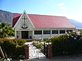 New Apostolic Church
 -
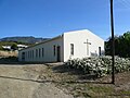 Evangelical Reformed Church of SA
 -
 Interdenominational Church


Notable people
[edit]- Giniel de Villiers (born 1972), rally driver and 2009 Dakar Rally winner.
References
[edit]- ^ a b c d "Main Place Barrydale". Census 2011.
- ^ Raper, P. E. (1989). Dictionary of Southern African Place Names. Jonathan Ball Publishers. p. 69. ISBN 978-0-947464-04-2 – via Internet Archive.
Municipalities and communities of Overberg District Municipality, Western Cape | ||
|---|---|---|
District seat: Bredasdorp | ||
| Cape Agulhas | .svg) | |
| Overstrand | ||
| Swellendam | ||
| Theewaterskloof | ||
Barrydale
View on Grokipediafrom Grokipedia
Geography
Location and Topography
Barrydale is situated in the Western Cape province of South Africa at coordinates 33°54′13″S 20°43′18″E.[9] The town encompasses an area of 25.77 km² and lies at an elevation of approximately 500 meters above sea level.[10][9] Positioned at the northern end of the Tradouw Pass, Barrydale serves as a key link between the Overberg region to the south and the Klein Karoo to the north.[11] The settlement occupies the Tradouw Valley, enveloped by the towering Langeberg Mountains to the south and west, which form a dramatic backdrop of rugged peaks and slopes.[12] This valley features fertile arable land, supported by reliable water sources, that has long drawn inhabitants to the area for its agricultural potential.[13][14] As a prominent stop on Route 62, Barrydale functions as a gateway connecting Cape Town eastward to the Garden Route, offering travelers access through the scenic interior of the Western Cape.[15] The town is located about 50 km north of Swellendam, accessible via the winding Tradouw Pass.[16]Climate
Barrydale features a warm temperate climate characterized by mild temperatures and low annual precipitation, primarily influenced by its position in the Little Karoo region. The area is classified under the Köppen-Geiger system as Csb, a warm-summer Mediterranean climate, with an average annual rainfall of approximately 450 mm, most of which occurs during the winter months. This rainfall pattern results in a relatively dry environment overall, with precipitation concentrated between May and August, contributing to the region's semi-arid characteristics while providing sufficient moisture for local ecosystems.[17][18][19] Summers in Barrydale, spanning November to February, are warm and predominantly dry, with average daytime temperatures around 25°C and occasional highs reaching up to 35°C. These months typically see minimal rainfall, often less than 10 mm per month, fostering clear skies and comfortable conditions during the day, though afternoons may bring a cooling coastal breeze. Nighttime temperatures remain mild, averaging above 15°C, which supports outdoor activities without extreme heat stress.[17][18] In contrast, winters from June to August are mild and wetter, featuring bright, sunny days with average temperatures ranging from 10°C to 15°C during the day. Nights can be notably colder, dipping to around 5–6°C, with occasional frost occurrences that add a crisp element to the season. Rainfall is highest in June, averaging about 22 mm over several days, which helps maintain soil moisture without excessive flooding. This seasonal shift influences daily life by necessitating preparations for cooler evenings and leveraging the brighter winter days for community routines.[17][18] Barrydale's microclimate, shaped by its location in a sheltered valley, offers a more reliable water supply than the surrounding drier Karoo regions, where annual precipitation often falls below 250 mm. This relative abundance supports vegetation and water availability, distinguishing the area from the broader semi-arid landscape.[20][17]History
Indigenous and Early Settlement
The area encompassing present-day Barrydale, referred to as Kannaland on a map produced in 1843, was originally inhabited by Khoi herders of the Attaqua group, who were part of the broader Khoisan peoples indigenous to southern Africa.[21][2] The name Kannaland derives from the genus Kanna (Mesembryanthemum species), a plant that these communities harvested, processed, and traded as early as the 1770s for its medicinal and intoxicating properties.[21][22] These indigenous groups utilized the Tradouw Valley's relatively higher rainfall and diverse topography—compared to the surrounding arid Karoo—for their livelihoods, establishing semi-permanent settlements in the fertile lowlands while ranging into the surrounding mountains of the Langeberg for seasonal activities.[2][22] The Attaqua, as pastoralists, herded livestock such as sheep and cattle in the valleys, while Khoisan hunter-gatherers exploited the rugged terrains for foraging wild plants, hunting small game, and collecting resources like kanna, sustaining a resilient adaptation to the Little Karoo's semi-arid environment.[21][22] The Attaqua also forged an early footpath through the Langeberg mountains, which later evolved into the Tradouw Pass and facilitated indigenous migration routes across the region.[2] In the early 18th century, as part of the broader expansion of the Dutch Cape Colony, European farmers began migrating eastward from the western Cape settlements into the Tradouw Valley, drawn by its arable soils, reliable water sources from rivers and springs, and potential for pastoral and crop farming.[4] This movement reflected the colony's growing need for new grazing lands amid increasing population pressures and the depletion of resources nearer to Cape Town, with settlers establishing isolated loan farms under the Dutch East India Company's oversight.[4] These initial holdings focused on wheat cultivation and livestock rearing, capitalizing on the valley's microclimate to support mixed agriculture in an otherwise challenging landscape.[4] The attraction of the fertile land gradually led to the formation of small, scattered farming communities by the mid-18th century, where families constructed basic homesteads, nagmaal houses for religious gatherings, and rudimentary schools, fostering informal social structures without formal urban planning.[4] These early establishments marked the transition from exploratory treks to more permanent occupation, integrating the area into the Cape Colony's frontier economy while displacing indigenous land use patterns.[4]Founding and Modern Development
Barrydale was formally established in 1882 on the farms Tradouw's Hoek and Moerasrivier, serving as a trading post and service center for local farmers in the Little Karoo region.[23] The town derives its name from Joseph Barry, a prominent 19th-century merchant who founded the trading firm Barry & Nephews in 1834, which played a key role in regional commerce and infrastructure development, including the construction of early stores and facilities in the area.[24] Initially, the settlement catered to agricultural needs, with farmers from surrounding districts using it as a hub for supplies and social gatherings. Early development featured "tuishuise," modest town houses constructed by farmers to accommodate stays during nagmaal, the Dutch Reformed Church's quarterly holy communion services, reflecting the community's reliance on periodic religious and market visits.[23] The Dutch Reformed Church (NG Church), a central landmark, was opened in 1908 with its clock and bells operational from that year, solidifying Barrydale's role as a religious and communal focal point.[25] Municipal status was granted in 1921, marking the town's transition from a loose farming outpost to a formally administered village with basic governance structures.[2] In the 20th century, Barrydale's growth accelerated with the development of Route 62 in the 1960s, including the construction of the Huisrivier Pass in 1966, which improved connectivity to neighboring towns like Ladismith and Montagu, facilitating easier access for trade and travel.[26] During the apartheid era (1948–1994), Barrydale was spatially divided along racial lines, with "white" areas in Upper Barrydale and "coloured" communities forcibly relocated to Lower Barrydale (also known as Steek My Weg), reflecting broader policies of segregation and Group Areas Act displacements.[27] Following the end of apartheid in 1994, Barrydale was incorporated into the newly formed Kannaland Local Municipality as part of the 2000 local government elections, which restructured administration to promote integration across previously divided communities.Demographics
Population Statistics
According to the 2011 South African census, Barrydale had a total population of 4,156 residents, with a population density of 161.3 inhabitants per square kilometer across an area of 25.77 square kilometers.[10] The town operates in the South Africa Standard Time zone (UTC+2), uses postal code 6750, and has the telephone area code 028.[28][29] Barrydale forms part of the Swellendam Local Municipality, which is situated within the Overberg District Municipality in the Western Cape Province.[30] As a rural settlement, it maintains a stable population characteristic of small towns in the region, with estimates suggesting around 4,200 permanent residents in recent years.[4] The Swellendam Local Municipality had a population of 39,474 as of the 2022 census, though Barrydale-specific data at the sub-place level from the 2022 census is not publicly available.[31] The population grew significantly from 2,444 in the 2001 census to 4,156 by 2011, reflecting an average annual increase of 5.5 percent during that decade.[10] This expansion has contributed to its current size, though growth has since stabilized amid ongoing rural dynamics.[4]Ethnic and Linguistic Composition
Barrydale's population exhibits a diverse ethnic composition reflective of broader patterns in the Western Cape province of South Africa. According to the 2011 South African Census, the racial makeup of Barrydale's 4,156 residents was predominantly Coloured at 83.3%, followed by White at 11.9%, Black African at 3.6%, Indian/Asian at 0.4%, and Other at 0.8%.[3]| Population Group | Percentage |
|---|---|
| Coloured | 83.3% |
| White | 11.9% |
| Black African | 3.6% |
| Indian/Asian | 0.4% |
| Other | 0.8% |
| First Language | Percentage |
|---|---|
| Afrikaans | 90.6% |
| English | 6.6% |
| isiXhosa | 1.1% |
| Other African languages | 1.7% |