Hubbry Logo
BethoronBethoronMain
Open search
Bethoron
Community hub
Bethoron
logo
8 pages, 0 posts
0 subscribers
Be the first to start a discussion here.
Bethoron
Bethoron
from Wikipedia
Upper Bethoron, drawing from 1880

Bethoron (Hebrew: בֵית־חוֹרֹ֔ן, lit.'house of Horon'; Ancient Greek: Ὡρωνείν), also Beth-Horon, were two neighboring towns in ancient Israel, situated on the GibeonAijalon road. They served as strategic points along the road, guarding the "ascent of Bethoron". While the Hebrew Bible sometimes distinguishes between the two towns—Upper and Lower Bethoron—it often refers to both simply as Bethoron.[1] The towns are mentioned in the Bible and in other ancient sources: Upper Bethoron appears in Joshua 16:5, Lower Bethoron in Joshua 16:3, both in 1 Chronicles 7:24,[2] and the ascent in I Maccabees 3:16.

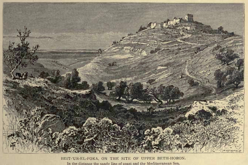
The ancient towns of Upper Bethoron and Lower Bethoron are identified respectively with the present-day Palestinian Arab villages of Beit Ur al-Fauqa and Beit Ur al-Tahta, which preserve the ancient names.[3][1] Archaeological evidence suggests that Lower Bethoron was established first, as the earliest potsherds discovered there date back to the Late Bronze Age, while those from the upper town originate from the Iron Age onward.[4]

Etymology

[edit]
R7G29 Z1 U33V28V4G1E23
N35
N25
bꜣtꜣ(j) ḥwꜣrwn[5][6]
in hieroglyphs
Era: 3rd Intermediate Period
(1069–664 BC)

The Hebrew name Bethoron (Beit Horon, בית חורון‎) is derived from the name of an Egypto-Canaanite deity, Horon, mentioned in Ugaritic literature.[2][7][3] The city is mentioned among the cities and towns smitten by Sheshonq I in his inscription at the Temple of Karnak as Batae Houarn.[5][6]

Ascent of Beth-horon

[edit]

The biblical "way of Beth-horon", also known as "the ascent of Beth-horon", is a pass which ascends from the plain of Aijalon (now Ayalon-Canada Park) and climbs to Beit Ur al-Tahta (1,210 ft.). It then ascends along the ridge, with valleys lying to north and south, and reaches Beit Ur al-Fauqa (2,022 ft.). Al-tahta means 'the lower', and al-fauqa (fawqa) means 'the upper' in Arabic.

The ascent is an ancient east-west trade route connecting two broadly north-south routes, the Via Maris along the Mediterranean coastline, and the Way of the Patriarchs, which follows the crest of the central mountain range of Samaria in the north and Judah in the south.

History

[edit]

Iron Age: in the Bible and contemporary texts

[edit]

Upper Bethoron is first mentioned in the Book of Joshua as a city on the border between the Israelite tribes of Benjamin and Ephraim (Joshua 16:5). The borderline passed alongside the two Bethorons (Joshua 16:5; 21:22[8]) who belonged to the latter Israelite tribe and therefore, later on, to the Northern Kingdom of Israel, while the tribe of Benjamin belonged to the Kingdom of Judah. One or both of the towns was a Levitical city (Joshua 21:22; 2 Chronicles 6:53[9]).[1]

According to biblical records, these cities were conquered by the Israelites under the leadership of Joshua, who defeated the five Amorite kings near Gibeon and pursued them southward past Beth-Horon to Azekah and Makkedah (Joshua 10:5-11). According to the Bible, when Joshua defeated the Amorite kings, "he killed a large number of them at Gibeon, and chased them by the way of the 'Ascent of Beth-horon'".[10][1]

Later on, the Philistines chose to launch their attack against Saul via the route passing through Beth-Horon (1 Samuel 13:18), sending a company of their men to hold "the way of Beth-horon".[1]

Upper Bethoron is later mentioned in 2 Kings as one of the cities built and fortified by Solomon (1 Kings 9:17, also in 2 Chronicles 8:59). Solomon "built Beth-horon the upper, and Beth-horon the nether, fortified cities, with walls, gates, and bars" (2 Chronicles 8:5;[11] 1 Kings 9:17[12]).[1]

From Egyptian sources it appears that Bethoron was one of the places conquered by Shishak of Egypt from Rehoboam.[13] It may also be the Bethoron mentioned in a 8th/7th century ostracon found at Tel Qasile, which reports the transfer of 30 sheqels of Ophir gold to Bethoron.[14][15]

According to 1 Chronicles 7:24,[16] Lower Bethoron was built by She'era, daughter of Beriah, son of Ephraim.[2] The Second Book of Chronicles mentions Beth-Horon in the context of disbanded Israelite mercenaries in Amaziah's army who looted towns in Judah "from Samaria to Beth-Horon" (2 Chronicles 25:13).[1]

Hellenistic period

[edit]

The Syrian (Seleucid) general Seron was defeated here in 166 BCE by Judas Maccabeus (1 Macc. 3:13–24[17]) in the Battle of Beth Horon. Six years later Nicanor, retreating from Jerusalem, was defeated and slain (1 Macc. 7:39;[18] Josephus, Antiquities Bk12 Ch10:5.[19])

Bacchides repaired Beth-horon "with high walls, with gates and with bars and in them he set a garrison, that they might work malice upon ("vex") Israel" (1 Macc. 9:50–51[20]). Later, the Jews fortified it against Holofernes (Judith 4:4–5[21]).

Roman period

[edit]

There are traces of an ancient Roman paving still visible.

In the battle of Beth Horon in the year 66 CE, the first decisive Jewish victory in the First Jewish–Roman War the Roman general Cestius Gallus was driven in headlong flight before the Jews.[22]

Late Roman & Byzantine periods

[edit]

Eusebius' Onomasticon mentions the 'twin villages' and St. Jerome describes them as 'little hamlets.' [2][23]

Jerome (late 4th to early 5th centuries) noted that Bethoron was just a little village at his time. In his eulogy for Saint Paula, he describes Lower and Upper Bethoron as cities founded by Solomon and destroyed by war.[24]

Arab villages

[edit]

The two Palestinian Arab Muslim villages of Beit Ur el-Fauqa and Beit Ur et-Tahta preserve the HebrewCanaanite name,[2] and have been identified as the sites of Upper and Lower Bethoron.[3]

Modern period

[edit]

In 1915, the Palestine Exploration Fund wrote that changes in the main road to Jerusalem had left the Bethoron route "forsaken" and "almost forgotten".

The Israeli settlement of Beit Horon was founded in 1977 on a site adjacent to the two Arab towns.

Highway 443 follows part of the ancient road.

Archaeology

[edit]

Archaeological finds indicate that the lower town was established before the upper one. Potsherds from the Late Bronze Age onward were discovered at Lower Beit Ur, whereas those in Upper Beit Ur date only from the Iron Age onward.[2]

References

[edit]

Bibliography

[edit]
[edit]
Revisions and contributorsEdit on WikipediaRead on Wikipedia
from Grokipedia
Beth-horon designates two ancient towns in the territory of in ancient : Upper Beth-horon and Lower Beth-horon, positioned along a vital pass connecting the to the central highlands. These settlements, credited to Sheerah, daughter of son of , controlled a key military route repeatedly contested in regional conflicts. King Solomon fortified both as defended cities with walls, gates, and bars during his reign. The Beth-horon pass gained prominence in biblical accounts for decisive Israelite victories, notably Joshua's pursuit of the Amorite coalition where large hailstones from heaven struck the fleeing enemy, exceeding battle casualties. Egyptian pharaoh (biblical ) listed Beth-horon among sites under his influence during his campaign against . In the Hellenistic era, leveraged the terrain for ambushes against Seleucid forces, securing triumphs that bolstered the Hasmonean revolt. Archaeological traces Lower Beth-horon's origins to the Late , underscoring its enduring strategic value.

Geography and Etymology

Location and Topography

Bethoron comprises Upper Beth-horon and Lower Beth-horon, two adjacent ancient settlements in the territory of , positioned along the vital Gibeon-Aijalon road in central ancient . This route served as a primary ascent connecting the coastal plain near Aijalon to the Judean hill country, approximately 16 kilometers northwest of and 37 kilometers southeast of Joppa. The sites correspond to modern villages (Upper) and Beit Ur al-Tahta (Lower), situated about 2.5 kilometers apart on parallel hilltops. The topography of the Beth-horon pass features a steep, winding incline rising from the lowlands of the Aijalon , guarded by the Lower town at its base and the Upper town higher up the ridge. Upper Beth-horon occupies an of roughly 595 meters above , overlooking valleys and wadis that channel the ascent toward the plateau near Gibeon. This rugged terrain, marked by narrow flanked by hills, created a natural bottleneck ideal for defense, with the road descending westward through a valley to the coastal plain. The strategic elevation difference and confined paths amplified the pass's significance across eras.

Origins of the Name

The name Bethoron (Hebrew: בֵּית־חוֹרֹן, beit ḥōrōn), referring to both Upper and Lower Bethoron, is a theophoric toponym meaning "House of Horon," with beth denoting "house" or "temple" and Horon (also rendered Hauron or Ḥôrôn) identifying a Canaanite deity attested in Ugaritic texts from the 14th–12th centuries BCE and Egyptian records from the New Kingdom period onward. Horon appears as a chthonic figure associated with magic, the underworld, and possibly storm elements, often paired with Baal in Levantine mythology, reflecting pre-Israelite religious influences in the region's settlement patterns. This divine origin aligns with common ancient Near Eastern practices where place names incorporated deities to signify cult centers or protected locales, as seen in parallels like Beth-Anath or Beth-Shemesh; textual evidence from (modern Ras Shamra) describes Horon's role in incantations and divine assemblies, supporting his prominence in Canaanite pantheons during the Late when the sites were established. Alternative derivations proposing a purely topographic sense—"house of the hollow" or "house of caves"—stem from associating ḥôr with for cavity or freeman, potentially referencing the steep, cavernous pass where the towns lie, but these lack the direct attestation of the in contemporaneous sources and are considered secondary folk etymologies by most biblical scholars. The persistence of the name into (e.g., 10:10, 16:5) indicates Israelite adaptation of Canaanite nomenclature without altering its theophoric core.

Strategic Importance

The Ascent of Beth-horon

The Ascent of Beth-horon denotes the rugged, narrow uphill route linking Lower Beth-horon in the Aijalon Valley to Upper Beth-horon approximately 800 meters higher on the Judean ridge, spanning about 5 kilometers of steep terrain that funnels traffic into a defensible bottleneck. This pathway, integral to the Gibeon-Aijalon road, controlled access from the coastal plain westward invasions toward , rendering it a pivotal for commerce and conquest since at least the Late . Militarily, the ascent's topography—characterized by sheer cliffs and limited width—facilitated ambushes against ascending forces, as attackers from higher ground could rain projectiles on elongated columns marching single-file. Joshua exploited this during the Israelite conquest circa 1400 BCE, pursuing five Amorite kings from Gibeon along the route, where a hailstorm reportedly killed more enemies than Israelite swords (Joshua 10:10-11). In the Maccabean Revolt of 167-160 BCE, Judas Maccabeus leveraged the pass's constraints to defeat Seleucid general Seron, whose 800 cavalry and infantry were routed after a surprise descent from the heights, with fleeing survivors abandoning equipment (1 Maccabees 3:13-24). Similarly, in October 66 CE, Jewish forces under Simon bar Giora ambushed Roman legate Cestius Gallus's 20,000-strong army on the ascent, slaughtering around 5,800-6,000 legionaries and seizing the Twelfth Legion's aquila standard, a humiliation that precipitated Vespasian's Judean campaign. Egyptian pharaoh Shishak's inscription from circa 925 BCE lists Beth-horon among his conquests, underscoring the route's enduring value, while Hasmonean leader Bacchides fortified the towns in 160 BCE to secure the pass against rebels. These engagements highlight how dominance of the ascent repeatedly decided control over Judea's , with archaeological traces of ancient roads persisting into modern Highway 443.

Military Role Across Eras

The Beth-horon pass, connecting the to the Judean highlands via a narrow, steep ascent between Upper and Lower Beth-horon, has historically functioned as a vital chokepoint, facilitating control over inland routes while enabling ambushes against descending forces. Its topography favored defenders, as invading armies from the west were vulnerable to attacks from higher ground, a dynamic exploited in multiple conflicts. In the Israelite conquest of Canaan, circa 1400–1200 BCE, the pass featured prominently in Joshua's pursuit of a five-king Amorite after the battle at Gibeon, with the routing the enemy down the descent to Beth-horon amid hailstones that reportedly killed more foes than Israelite swords (Joshua 10:10–11). This engagement secured southern for the tribes, leveraging the terrain for rapid downhill advances. By the BCE, King reinforced Upper and Lower Beth-horon as fortified cities with walls, gates, and bars to safeguard the strategic corridor against incursions, alongside store cities for logistical support (2 Chronicles 8:5). During the against Seleucid rule, in spring 166 BCE, led a force of about 600–1,000 against Seleucid commander Seron, whose army numbered several thousand; positioned at the ascent, Judas's troops crushed the invaders, pursuing survivors down to the plain and slaying around 800, per the account in 3:13–24. This victory, achieved through surprise and elevation advantage, elevated Judas's leadership and weakened Seleucid momentum in . In the , autumn 66 CE, Jewish irregulars ambushed the Roman column of Legate Cestius Gallus—comprising the XII Legion (partial strength), , and Syrian levies totaling roughly 20,000–30,000 overall but with a of about 6,000—while withdrawing through the pass; boulders and flanking attacks from heights decimated the , resulting in approximately 6,000 Roman deaths, including centurions and the loss of a legionary eagle, as detailed by Flavius . This rare provincial triumph over Roman arms, enabled by the pass's bottlenecks, prolonged the revolt but ultimately contributed to escalated Roman reprisals under and . No major military engagements at Beth-horon are recorded in later eras, though its defensibility retained regional value into Byzantine and Islamic periods.

Biblical and Iron Age History

Accounts in Joshua and Maccabees

In the Book of Joshua, Beth-horon features prominently in the narrative of the Israelite conquest of Canaan. During the pursuit of a coalition of five Amorite kings who had attacked Gibeon, Joshua's forces chased the fleeing Amorites from Gibeon down to Azekah and Makkedah, passing through the descent of Beth-horon, where the Lord intervened by casting down large hailstones from heaven, slaying more enemies by hail than by the sword of Israel. This event is dated contextually to the late 13th century BCE in traditional chronologies of the biblical text, emphasizing the strategic chokepoint of the Beth-horon pass in facilitating the rout. Upper Beth-horon is also referenced as a boundary marker on the border between the tribes of Ephraim and Benjamin (Joshua 16:5), while both Upper and Lower Beth-horon delineate territorial limits in Ephraim's allotment (Joshua 16:3; 18:13–14), and they were later assigned as Levitical cities (Joshua 21:22). The Books of recount Beth-horon's role in the against Seleucid rule in the BCE. In 3:13–24, , leading a small force of about 1,000 men, ambushed the Syrian commander Seron and his larger army of unspecified size as they ascended the steep Beth-horon pass toward ; Judas's tactical advantage in the terrain allowed his troops to charge from higher ground, routing the Syrians down the descent, resulting in approximately 800 enemy dead and the survivors fleeing toward the coastal plain. This victory, occurring around 167 BCE, bolstered Jewish resistance early in the revolt by demonstrating the pass's defensibility against superior numbers, a recurring motif in the region's . The account attributes success to divine favor and Judas's resolve, without detailing troop compositions beyond the disparity.

Fortifications and Solomon's Era

During the reign of (c. 970–931 BCE), the attributes the of Upper Beth-horon and Lower Beth-horon to his extensive projects aimed at bolstering the kingdom's defenses and infrastructure. 2 Chronicles 8:5 states that "built upper Beth-horon and lower Beth-horon, fortified cities with walls, gates and bars," integrating these sites into a network that included storage cities, stations, and other fortified locations such as Baalath and Tamar. This work followed the completion of the and involved conscripted labor from non-Israelite populations, as detailed in the surrounding verses. 1 Kings 9:17 complements this by recording that rebuilt Lower Beth-horon alongside , emphasizing repairs or enhancements to existing settlements rather than entirely new constructions in some cases. The dual sites' positioning along the critical Beth-horon ascent—a narrow, steep route connecting the to the central highlands—underscored their defensive value, serving as chokepoints to control access toward and deter invasions from Philistine or other western territories. These biblical descriptions portray the fortifications as featuring robust walls, barred gates for secure entry, and structural reinforcements typical of II military architecture, though direct archaeological attribution to 's era remains under investigation in subsequent studies.

Archaeological Corroboration

Archaeological surveys at Lower Bethoron (modern Beit Ur al-Tahta) have uncovered potsherds dating to the Late Bronze Age (ca. 1550–1200 BCE), establishing the site's occupation prior to the Israelite conquest narratives in 10, where the descent from Beth-horon features prominently in the battle against the Amorite coalition. This pre- presence aligns with the strategic topography of the Beth-horon pass, suggesting early settlement exploitation of the route for control over ascent from the Aijalon Valley to the Judean hills. Iron Age continuity is evidenced by artifacts such as an olive press, indicating agricultural and economic activity during the period associated with the United Monarchy. Upper Bethoron (Beit Ur al-Fauqa) shows later initial development, with remains confirming fortified settlement patterns consistent with biblical accounts of Solomonic construction (1 Kings 9:17; 2 Chronicles 8:5). The Egyptian Shoshenq I's topographical list on the Bubastite Portal at (ca. 925 BCE) explicitly names Beth-Horon (no. 24) among subdued sites in the central highlands, providing near-contemporary extra-biblical verification of the location's geopolitical significance during the early Divided Monarchy, shortly after Solomon's purported fortifications. This inscription, detailing over 150 toponyms from Shoshenq's campaign against , underscores Beth-oron's role as a chokepoint without relying on later interpretive biases. Nearby salvage excavations along the ancient Beth-horon road, such as at the Hill of Moreh, have yielded II (ca. 1000–586 BCE) pottery sherds and structural remains, including walls enclosing living surfaces, tentatively dated to this era and indicative of roadside installations supporting regional traffic and defense. These findings corroborate the biblical depiction of Beth-horon as a militarily vital corridor, though full-scale digs at the core sites remain constrained by modern habitation, limiting direct attribution to specific Solomonic engineering. Overall, the material record affirms strategic investment without contradicting scriptural chronologies, privileging empirical over unsubstantiated minimalist revisions.

Post-Biblical Historical Periods

Hellenistic and Maccabean Revolt

During the following Alexander the Great's conquests, the region encompassing Bethoron fell under Ptolemaic control until approximately 200 BCE, when Antiochus III of the defeated Ptolemy V at the Battle of Paneas, incorporating into Seleucid territory. , ascending in 175 BCE, intensified efforts, including cultural impositions and restrictions on Jewish practices, culminating in the desecration of the in 167 BCE, which sparked the led initially by and then his son . Bethoron's strategic position along the vital ascent from the coastal plain to the Judean highlands made it a key chokepoint for Seleucid military movements into the interior, rendering it a focal point for early clashes in the revolt. In response to Judas Maccabeus's initial guerrilla successes, Seron, the Seleucid commander of the forces in , assembled an army and advanced toward via the Bethoron pass around 166 BCE. According to , Seron approached the ascent of Beth-horon with a superior force, but Judas, leading a smaller contingent of committed fighters, positioned his men to exploit the narrow, steep terrain. The Jewish forces ambushed the Seleucids during the uphill advance, routing them and pursuing the survivors down the descent into the plain, where approximately 800 enemy soldiers were slain, with the remnants fleeing toward Philistine territories. This victory, detailed in 3:13-24, demonstrated the tactical advantages of the Bethoron pass's topography—its steep gradients and confined paths favored defenders against larger invading armies—and marked an early momentum shift in the revolt. The Battle of Beth Horon bolstered Judas's reputation and recruitment, enabling subsequent campaigns such as the victory at against , but it also prompted Antiochus IV to dispatch larger expeditions, underscoring Bethoron's recurring role as an entry route for reinforcements from Seleucid coastal strongholds. While primary accounts like emphasize divine favor and Jewish resolve, the outcome aligns with the pass's inherent defensibility, as evidenced by its use in later conflicts, though Seleucid numerical superiority eventually necessitated broader strategies beyond such bottlenecks. No archaeological evidence specifically ties Hellenistic fortifications to Bethoron from this era, but the narrative's consistency across deuterocanonical texts supports its historicity as a pivotal engagement in resisting .

Roman and Byzantine Eras

In 66 CE, during the opening phases of the First Jewish-Roman War, the Bethoron pass became the site of a pivotal by Jewish rebels against Roman forces. The Roman governor of , Cestius Gallus, led approximately 20,000 troops, including the , toward but retreated after failing to capture the city; en route through the narrow, steep ascent near Bethoron, the Romans suffered heavy casualties from coordinated Jewish attacks involving rocks, boulders, and slings from the heights, losing around 6,000 men and the legion's eagle standard. This tactical victory, leveraging the terrain's defensibility, temporarily disrupted Roman control and boosted rebel morale, though it precipitated harsher reprisals leading to Jerusalem's fall in 70 CE. The pass's strategic value persisted under direct Roman administration, with infrastructure enhancements including paved roads linking coastal ports like to inland , facilitating movements and commerce amid Judaea's provincial reorganization post-revolt. Bethoron itself likely functioned as a village, though sparse literary references limit details on local or demographics beyond its role in regional connectivity. By the Byzantine period (c. 324–638 CE), the area integrated into the province of , with the Bethoron route maintaining prominence for , trade, and military logistics between and the coast. Christianization of the region is evidenced by a 5th-century church at nearby Khirbet Huriya, featuring stairs inscribed with "Beth Horon," indicating ecclesiastical activity tied to the ascent's biblical associations. Settlement continuity is inferred from broader hinterland patterns of rural villages and monasteries supporting Jerusalem's patriarchal see, though no major recorded events or imperial edicts specifically highlight Bethoron.

Islamic Conquest to Ottoman Rule

The region encompassing Upper and Lower Bethoron was incorporated into the as part of the of the , which defeated Byzantine forces by 640 CE following key victories such as the Battle of Yarmouk in 636 CE. Settlement in the area exhibited continuity into the early Islamic period, with the villages functioning as agricultural communities along the vital Jerusalem-to-coastal-plain route under Umayyad and Abbasid administration. Subsequent dynasties, including the Fatimids, Seljuks, and Ayyubids, maintained control over amid periodic disruptions like the Crusader interlude (1099–1187 CE), after which reasserted Muslim dominance in the region. Under rule (1260–1517 CE), the twin villages of Bayt ʿUr al-Fawqā and Bayt ʿUr al-Taḥtā—corresponding to Upper and Lower Bethoron—remained modest rural habitations, with the strategic pass retaining its transit importance despite no recorded major fortifications or battles specific to the site. The assumed control following its defeat of the Mamluks in the 1516–1517 campaign, integrating the area into the Sanjak of . Late 16th-century Ottoman tax registers (tahrir defterleri) document Bayt ʿUr al-Taḥtā with 24 Muslim households, assessed for taxes totaling 7,800 on crops like and , vineyards, fruit trees, , and occasional revenues; similar modest demographics applied to Bayt ʿUr al-Fawqā. Architectural surveys reveal surviving medieval Islamic and Ottoman-era structures in Bayt ʿUr al-Fawqā, such as vaulted buildings and a possible maqam (saint's shrine), underscoring persistent low-density settlement focused on and road-related activities through the Ottoman period until the late .

Modern Developments

Arab Villages and Pre-1948

The Bethoron area was home to two Arab villages, (Upper Beit 'Ur) and Beit 'Ur al-Tahta (Lower Beit 'Ur), which occupied the sites of ancient Upper and Lower Bethoron respectively during the Ottoman and British Mandate eras. These villages, predominantly Muslim, engaged primarily in , cultivating crops such as olives, grapes, and cereals on terraced lands along the strategic Jerusalem-Jaffa road. In the late 16th century, Ottoman tax registers recorded Beit 'Ur al-Tahta (as Bayt 'Ur as-Sufla) within the Nahiya of Quds, while had nine households, indicating small, stable rural communities. By the British Mandate period, the villages fell under the subdistrict, with land areas of 3,762 dunams for al-Fauqa and 4,619 dunams for al-Tahta in 1945 surveys. Population censuses reflect modest growth amid rural Palestinian demographics. In 1922, had 147 Muslim inhabitants, rising to 210 by 1945; Beit 'Ur al-Tahta counted 470 Muslims in 1922, increasing to 710 in 1945, with all residents Muslim in both cases per official statistics. These figures, drawn from British Mandate records, underscore the villages' continuity as agricultural hamlets without significant non-Muslim or urban elements prior to 1948.

Establishment of Beit Horon Settlement

Beit Horon was established in December 1977 by approximately 100 settlers from the movement, a religious nationalist group advocating Jewish settlement in biblical and . The Israeli government approved the initiative, allowing to occupy two existing army camps along the Latrun-Ramallah road, midway between and the coastal plain. This location, adjacent to the Palestinian villages of and Beit Ur al-Tahta, leveraged the area's historical strategic significance for controlling access routes, as evidenced by ancient fortifications at the nearby Bethoron sites. The founding reflected broader post-1967 efforts to populate the with Jewish communities following Israel's capture of the territory in the . Israeli authorities designated the land as state property available for settlement, enabling rapid initial development despite international disputes over the status of the area. Gush Emunim's role underscored the ideological drive to reclaim biblical heartlands, with the community organized as a communal religious emphasizing cooperative living and religious observance. Early infrastructure focused on residential housing and security perimeters, growing from the provisional camps into a permanent outpost that bolstered regional connectivity via what became Highway 443.

Security Incidents and Strategic Value

The Beit Horon settlement, located along Highway 443 in the , occupies a position of enduring strategic significance due to its placement atop the ancient Beth Horon pass, a narrow ascent the to the Judean highlands. This route has historically served as a critical chokepoint for military and commercial transit, vulnerable to ambushes owing to its steep terrain and limited access points, a feature that persists in modern logistics as Highway 443 facilitates essential travel between , Modiin, and . Control of this corridor enhances Israeli security by securing supply lines and rapid response capabilities in the region, while its exposure has necessitated fortified barriers and patrols to counter asymmetric threats from adjacent areas. Security incidents in and around Beit Horon have underscored these vulnerabilities, particularly during periods of heightened Palestinian violence. On , , two Palestinian assailants from the nearby village of Beit Ur al-Tahta infiltrated the settlement and stabbed two Israeli women in separate attacks; Shaked Weiss, aged 42, succumbed to her wounds the following day at in , while the second victim survived. A settlement neutralized both attackers by gunfire, preventing further casualties. This event, part of a broader wave of and vehicular assaults, highlighted infiltration risks despite perimeter , prompting enhanced and resident preparedness measures. Additional threats have included false alarms simulating terror infiltrations, such as on July 14, 2022, when an Israeli civilian scaling the settlement's outer fence triggered alarms, leading to a temporary and search; the incident was resolved without violence but exposed ongoing alert protocols. The settlement has also faced ancillary risks from rock-throwing and potential car-rammings along adjacent Highway 443, though specific data attributes fewer direct vehicular incidents to the site compared to the 2016 stabbing. These episodes reflect the dual-edged nature of the location: its strategic elevation provides defensive advantages, yet proximity to hostile villages amplifies exposure to low-tech attacks, informing Israel's emphasis on settlement-based deterrence in the Samarian highlands.

Archaeology and Ongoing Research

Key Excavation Sites

Archaeological investigations at Bethoron have focused on surveys and limited salvage excavations, revealing of continuous occupation from the Late Bronze Age onward. In (Beit Ur al-Fauqa), an architectural and archaeological survey conducted in 1998 and 1999 documented medieval and Ottoman structures alongside ancient features, including a portion of the Roman road, an oil press, burial caves, and a rock-cut wine press. These findings underscore the site's role along the strategic ascent between and the . At Lower Bethoron (Beit Ur al-Tahta), surface surveys have identified potsherds dating to the Late Bronze Age, suggesting it predates the upper settlement in establishment. Additional sites nearby, such as Khirbet Khallaba and Ash Sheikh shrines, indicate broader archaeological interest in the vicinity, though systematic excavations remain limited. The Bethoron pass itself features prominent remains of the Roman-era road, with sections exposed through salvage work along modern Highway 443, confirming its use as a key route from to via Beit Horon. These road segments, dating to approximately 1800 years ago, highlight the area's enduring transportation significance.

Artifacts and Interpretations

Archaeological surveys at Lower Beit Horon (Beit Ur al-Tahta) have uncovered sherds dating to the Late Bronze Age, indicating settlement origins in the Canaanite period prior to Israelite dominance. These finds, including diagnostic fragments consistent with regional Late Bronze II pottery forms, suggest continuous occupation from at least the 15th–13th centuries BCE, aligning with broader Judean highland patterns of small-scale agrarian communities transitioning into the . Upper Beit Horon () yields later ceramics, implying secondary development as an extension of the lower site's strategic position along ascent routes. A significant epigraphic artifact is the Iron Age ostracon discovered at Tel Qasile near , inscribed in Hebrew with the phrase " of for Beth-Horon, 30 shekels," dated paleographically to the BCE. Excavated in 1946 by B. Maisler (later Mazar), this fragment records a transaction of approximately 225 grams of , sourced from the biblical region, destined for Beth-Horon—providing direct extrabiblical attestation of the toponym during the late monarchic period. Interpretations of these artifacts emphasize Beth-Horon's role in Iron Age Judah's administrative and economic networks, with the ostracon evidencing fiscal transfers possibly linked to royal or cultic allocations, as Ophir gold appears in biblical accounts of Solomonic trade (1 Kings 9:28). Ceramic evidence supports historical continuity from Bronze Age Canaanite villages to fortified Iron Age outposts, corroborating biblical references to the site's fortification by Solomon (2 Chronicles 8:5) without implying direct Solomonic construction, given the 10th-century dating challenges in regional stratigraphy. Scholars caution that the ostracon's provenance at Tel Qasile reflects coastal-Judean commerce rather than on-site production, underscoring interpretive limits from indirect evidence amid sparse primary excavations at the twin sites.

Debates on Historical Continuity

The identification of biblical Upper Bethoron with the village of and Lower Bethoron with Beit Ur al-Tahta rests on consistent toponymic preservation—"Beit Ur" deriving from ancient "Beth Horon"—and their location along the strategic Roman road (Via Hadriana) connecting the to , matching descriptions in 16:3–5 and 1 Chronicles 7:24 as twin settlements built by Sheerah, daughter of . Archaeological surveys confirm Late fortifications, including ramparts and gate complexes, at both sites, evidencing their role as defensive chokepoints predating Israelite settlement and aligning with Letter 290's mention of Bit-Ninurta (possibly an early form of Beth Horon) as a regional power center around 1350 BCE. Debates center on the timing and nature of settlement continuity from Canaanite to Israelite periods, with pottery scatters indicating Lower Bethoron occupied from the Late (ca. 1550–1200 BCE), while Upper Bethoron's earliest substantial remains date to II (ca. 1000–586 BCE), suggesting the upper site may have developed as an extension during early expansion rather than concurrently. Limited Iron I (ca. 1200–1000 BCE) finds at either location fuel minimalist arguments that Israelite emergence involved gradual sedentarization of pastoralists rather than widespread conquest, though maximalists counter that the strategic upgrades in Iron II reflect biblical attributions to (1 Kings 9:17–18) or administrative reorganization under Davidic rule. Evidence for post- continuity is stronger, with Roman-era milestones and Byzantine-era agricultural terraces attesting persistent use of the Bethoron pass, but sparse Persian-period (ca. 539–332 BCE) artifacts prompt questions about depopulation gaps following Babylonian destruction in 586 BCE. Excavations at Lower Bethoron in 1971 and 2001 uncovered Hellenistic and Roman strata overlying layers, supporting uninterrupted strategic habitation, yet the scarcity of early Islamic finds (pre-7th century CE) highlights interpretive challenges in tracing transitions amid conquests. Medieval Crusader structures, including a 12th-century hall-tower in Upper Bethoron, demonstrate reoccupation tied to the road's enduring value, underscoring physical site persistence over ethnic or cultural uniformity. These patterns affirm Bethoron's role as a resilient nodal point, though debates persist on whether archaeological gaps reflect abandonment or undiscovered rural shifts, with calls for integrated geophysical surveys to resolve stratigraphic ambiguities.

References

Add your contribution
Related Hubs
User Avatar
No comments yet.