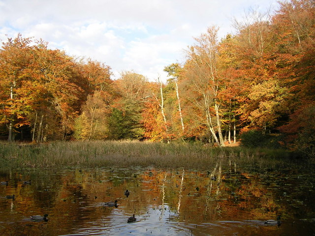
Hubbry Logo
Burnham BeechesBurnham BeechesMain
Open search
Burnham Beeches
Community hub
Burnham Beeches
logo
8 pages, 0 posts
0 subscribers
Be the first to start a discussion here.
Burnham Beeches
Burnham Beeches
from Wikipedia

Burnham Beeches is a 374.6-hectare (926-acre) biological Site of Special Scientific Interest situated west of Farnham Common in the village of Burnham, Buckinghamshire. The southern half is owned by the Corporation of London and is open to the public.[1][2] It is also a National Nature Reserve and a Special Area of Conservation.[3][4]

Key Information

Burnham Beeches came into ownership of the City of London Corporation after the land came up for auction in 1879. The auction followed the death of the land owner who had permitted public access. Its special status was recognised and discussed in the House of Commons. The land failed to sell at the auction. Subsequently Sir Henry Peek purchased the land at the reserve price £12,000. Sir Henry Peek sold 374 acres (151 hectares) to the City of London Corporation (£6,000), retaining the "enclosed" portion of the land of 175 acres (71 hectares). Purchase was funded from duties levied on grain landed at the Port of London. Money was also spent on roads to improve access (estimated cost £500), one of these is named after Sir Henry. At this time local authorities were encouraged to provide open spaces with public access to provide some relief from polluted towns and cities. (Summarised from Hansard and various contemporary newspaper reports.)

Preservation

[edit]
Druids Oak, the oldest tree in Burnham Beeches

The largely beech woodland has been regularly pollarded, with many trees now several hundred years old. Their age, and the amount of deadwood in and around them, means that the woodland is rich in wildlife. More than sixty of the species of plants and animals here are either rare or under threat nationally. The area is protected as a National Nature Reserve, Site of Special Scientific Interest and a candidate Special Area of Conservation.

Archaeology

[edit]

Seven Ways Plain hill fort is located in the south west part of Burnham Beeches. It is a rare example of a single rampart earthwork used either as a stock enclosures or possibly places of refuge. It comprises a range of earthworks which have been dated to the Late Bronze Age and Early Iron Age.[5] It is a Scheduled Monument.[6]

Filming

[edit]

The close proximity of Pinewood, Shepperton and Bray Studios and the outstanding natural beauty of the Beeches have made it a desirable filming location. Robin Hood Prince of Thieves, The Crying Game, First Knight, Goldfinger, The Princess Bride, the 1952 Disney film The Story of Robin Hood and His Merrie Men, Harry Potter and the Order of the Phoenix and Harry Potter and the Deathly Hallows – Part 1, Maleficent: Mistress of Evil, Deadpool & Wolverine, Horrible Histories: The Movie, and the Doctor Who story State of Decay are some of the films and TV productions that have been shot at Burnham Beeches.[7][8]

Filming is tightly controlled in recognition of the Beeches' international importance for wildlife. Filming is restricted to no more than twenty days per year and to certain times of year. Filming in environmentally sensitive areas has also been banned. Revenue from filming goes directly to fund the upkeep and management of the Beeches.

Affiliates

[edit]

Burnham, New Zealand, was named after the village of Burnham.[9]

Burnham Beeches F.C. are an amateur football team who currently compete in the East Berkshire Football League.[10]

See also

[edit]
Alfred de Bréanski Burnham Beeches

References

[edit]
[edit]
Revisions and contributorsEdit on WikipediaRead on Wikipedia
from Grokipedia
Burnham Beeches is an and wood-pasture site covering approximately 220 hectares (540 acres) in , , located to the west of near . It features predominantly beech-dominated semi-natural interspersed with , heathland, , and habitats, including pockets of bog, and is renowned for its gnarled, ancient pollard beech trees, many of which are several hundred years old. Acquired by the in 1880 under the Open Spaces Act of 1878 to prevent urban development, Burnham Beeches has been preserved as public open space ever since, with the southern portion managed as a National Nature Reserve (NNR) since 1993. It was designated a (SSSI) in 1951 due to its ecological value and later recognized as a European (SAC) to protect its biodiversity under international directives. The site's wood-pasture landscape, shaped by centuries of traditional management practices like for firewood and livestock grazing, supports a rich array of , including rare fungi, stag beetles, adders, tawny owls, and red kites. Conservation efforts at Burnham Beeches emphasize maintaining its ancient trees and diverse habitats through , such as controlled by and ponies to prevent scrub encroachment on heathlands and the restoration of pollards to sustain deadwood habitats essential for and birds. The reserve also includes Stoke Common, an adjacent 80-hectare heathland area acquired in 2007, enhancing the overall protected expanse and contributing to regional by preserving one of England's last remnants of lowland wood-pasture. Recent discoveries, such as new of fungi, underscore its ongoing scientific importance.

Geography and Location

Site Overview and Boundaries

Burnham Beeches is a 374.6-hectare biological situated west of in the village of , , with a central grid reference of SU950857. The area primarily consists of and former , forming a significant green space in southern . The boundaries of Burnham Beeches encompass a core managed zone of approximately 220 hectares owned by the , with extensions that integrate additional habitats and buffer zones, bringing the total designated extent to 374.6 hectares for the SSSI and 383.7 hectares for the adjacent . It borders notable adjacent areas such as Egypt Woods to the north, part of the Portman-Burtley Estate, Littleworth Common, an SSSI to the east, and Stoke Common, an 80-hectare heathland SSSI to the south acquired in 2007. Administratively, the site is managed by the as part of its commitment to public open spaces under the Open Spaces Act 1878, despite its location outside the capital. Positioned about 25 miles west of , it lies near the (Junction 7), facilitating easy access from urban areas while serving as a vital recreational outlet. Accessibility is provided through an extensive network of public footpaths totaling over 15 miles, three main car parks along Lord Mayor's Drive, and entry points from village, with additional options via bus from or and nearby railway stations at Burnham and . The site receives approximately 551,000 visitors annually (as of 2020), primarily day-trippers from within 10 km, underscoring its role as a popular natural escape.

Geology and Terrain

Burnham Beeches is underlain by Chilterns bedrock from the Upper period, approximately 85 million years old, formed from marine deposits of skeletons. This is overlain by the Palaeogene Lambeth Group, consisting of sands, clays, and pebbly beds deposited in coastal and fluvial environments around 54-56 million years ago, with clay-with-flints derived from dissolution and flint nodule concentration. Superimposed on these are plateau gravels, primarily the Winter Hill Gravel Terrace (450,000-500,000 years old) and younger Black Park Gravel Terrace, comprising sand, gravel, silt, and clay from Devensian meltwaters of the ancestral . The soils are predominantly acidic brown earths (pH 2.8-7.0), thin and free-draining, developed from the stony gravels and capped by wind-blown silts from the Ice Age, resulting in nutrient-poor conditions that favor beech woodland dominance. Wetter clay soils occur in valley pockets, with impeded drainage leading to iron pans, peaty layers, and mire formation in low-lying areas. These soil characteristics, combined with the gravelly substrate, create oligotrophic environments with low fertility, supporting sparse vegetation. The terrain forms a gently undulating plateau at elevations of approximately 70-90 meters above , shaped by Thames River terrace steps and glacial deposits, with subtle dry valleys and shallow streams like the Stream draining into swallow holes where surface water percolates through the . Open glades and ancient earth banks, remnants of historical boundaries from the onward, interrupt the , while historical on the nutrient-poor soils has promoted wood-pasture with scattered ancient pollards. This geological and topographical framework enhances habitat diversity, including wetter floors that preserve archaeological features.

History

Pre-Modern Ownership and Use

Burnham Beeches originated as part of the Royal Forest of Windsor during , serving primarily as a wood-pasture managed for both timber production and . Local villagers exercised common rights to graze pigs, , sheep, and horses amid pollarded and trees, while collecting , turf, and branches for and other uses. This , integral to the forest's , dates back to at least the 13th century, with evidence of early boundaries such as woodbanks and ditches delineating areas under different ownership or management regimes. Ownership remained with the Crown as part of the royal hunting and forestry domain until the 17th century, after which portions were sold to private estates, transitioning much of the land into held by the of East Burnham. Commoners from East Burnham village retained usage rights for grazing and resource gathering, overseen by structures like the East Burnham built between 1788 and 1796 to impound stray . Prehistoric activity is evidenced by features such as the Seven Ways Plain univallate , dating to the Late or Early (8th–5th centuries BC), likely used as a settlement or stock enclosure, and medieval remnants including the Hartley Court moated site (c. 1250–1350), which surrounded a farmstead with associated cultivated fields. Traditional management practices centered on pollarding cycles, typically every 15–25 years, where branches were cut above a height of about 1.5 meters to produce straight poles for fuel, , and while protecting regrowth from animals; this created the site's distinctive ancient, multi-stemmed shapes. By the , the landscape was largely enclosed through private agreements rather than parliamentary acts, gradually limiting common access as agricultural needs shifted. The decline in from the late onward, coupled with reduced , allowed vegetation to proliferate, transforming open wood-pasture into denser woodland over time.

Acquisition by the City of London

In 1879, following the death of its owner, the estate encompassing Burnham Beeches was placed on the market and auctioned as prime land suitable for the development of "superior residences," reflecting the rapid urbanization pressures of Victorian England. The auction initially failed to meet the reserve price, leading Sir Henry Peek to purchase the entire property for £12,000 before promptly reselling 374 acres (151 hectares) to the Corporation of the City of London for £6,000, thereby securing its future as public open space. This acquisition was a direct outcome of a concerted public campaign spearheaded by the Commons Preservation Society—now the Open Spaces Society—as part of the broader Victorian open spaces movement aimed at safeguarding commons and woodlands from encroaching development amid London's expansion. Enabled by the Open Spaces Act 1878, which empowered local authorities like the to purchase unenclosed lands for use, the purchase exemplified early efforts to preserve natural amenities for urban dwellers. The motivations were rooted in concerns over the loss of accessible green spaces, with advocates emphasizing the site's value and its role in and . Funding for the £6,000 purchase was drawn from revenues generated by duties on grain imported via the , a dedicated fund that the utilized for acquiring and maintaining open spaces during this period. Shortly after the acquisition, initial improvements included an allocation of approximately £500 for road enhancements to facilitate public access and for planting boundaries to delineate and protect the site's edges. These actions laid the groundwork for ongoing management, with the first formal plan adopted in 1885, prioritizing minimal human intervention to preserve the woodland's natural character and historical features like pollarded trees. Subsequent expansions enlarged the , with additions such as Egypt Woods acquired in 1947 and other purchases continuing through the early to mid-20th century, ultimately expanding the estate to 544 acres (220 hectares) by the . This growth reinforced the site's role as a conserved , linking directly to its later formal protection statuses.

Ecology and Biodiversity

Dominant Flora and Woodland Types

Burnham Beeches is characterized by its ancient semi-natural woodland, dominated by mature beech (Fagus sylvatica) trees, many of which are pollarded veterans exceeding 400 years in age, forming a distinctive wood-pasture landscape shaped by historical management practices. These ancient beeches exhibit multi-stemmed forms due to centuries of pollarding, which ceased approximately 200 years ago, contributing to their gnarled and hollow structures. Oak (Quercus petraea and Quercus robur), comprising about 20% of the veteran pollards, also features prominently, including the iconic Druids Oak estimated at around 800 years old, with sessile oak standards particularly noted in northern areas. The primary woodland type is beech-oak wood-pasture, featuring a of high forest, open grazed areas, and scattered pollards that maintain a varied canopy structure with dappled shade. Under the beech canopy, a dense (Ilex aquifolium) understory is common, alongside (Pteridium aquilinum) in oak-dominated zones, creating shaded conditions that limit undergrowth diversity. The ground flora reflects this character, with spring displays of (Hyacinthoides non-scripta), wood anemone (Anemone nemorosa), and wood sorrel (Oxalis acetosella), complemented by rarer species such as butcher's broom (Ruscus aculeatus) and wood spurge (Euphorbia amygdaloides). In more open or acidic areas, wavy hair-grass (Deschampsia flexuosa) and mosses prevail, while heathland pockets support heather (Calluna vulgaris) and dwarf gorse (Ulex minor). Habitat variations enhance the site's botanical diversity, including open glades with acid species and wet woodlands along streams dominated by () and (Salix spp.), where rushes and sedges thrive in mire conditions. Over 300 ancient trees, primarily and pollards, anchor these habitats, though natural regeneration faces challenges from beech dominance, heavy shading, and limited oak seedling establishment.

Fauna and Invertebrate Diversity

Burnham Beeches supports a diverse array of mammals, including roe deer and muntjac deer, which graze in the wood-pasture habitats, alongside smaller species such as fox, badger, weasel, stoat, rabbit, wood mouse, common shrew, and mole. Several bat species, totaling at least six recorded, roost in tree holes and contribute to insect control within the woodland. The site's birdlife is notably rich, featuring tawny owls, red kites, buzzards, kestrels, sparrow hawks, all three British woodpeckers (great spotted, lesser, and green), nuthatches, tree creepers, various tits (blue, great, long-tailed, and coal), pied and grey wagtails, snipe, stonechats, and skylarks, with scrub areas providing key nesting sites for summer migrants and ground-nesters. Reptiles thrive in the open, sunny southern sections of the reserve, with good populations of grass snakes, adders, slow worms, and common lizards utilizing heathland and glades for basking and hunting. Amphibians are well-represented in the ponds and wet areas, including common frogs, toads, palmate newts, and occasional great crested newts, the latter being a protected species that breeds in these aquatic habitats. The invertebrate diversity at Burnham Beeches is exceptional, particularly among saproxylic species dependent on dead and decaying wood from veteran pollard trees, with over 60 nationally rare or Red Data Book recorded, including beetles such as the violet click beetle, , lesser stag beetle, Minotaur beetle, and long-horned beetles, as well as flies, (over 250 species), potter wasps, dusky cockroaches, solitary mining bees, hornets, and tiger beetles. are abundant, with species like speckled wood, red admiral, white admiral, purple hairstreak, , and orange tip exploiting the varied woodland edges and clearings. The high volume of deadwood—targeted at over 40 cubic meters per on the ground and more than 50 standing dead trees per —underpins this richness. As part of the 's Environmental Change Network, the site contributes to long-term monitoring of trends, including bird transects, butterfly surveys, and invertebrate light traps, highlighting its role as a key indicator of .

Conservation and Management

Burnham Beeches holds multiple national designations that underscore its ecological importance. It was first notified as a (SSSI) in 1951, recognizing its diverse habitats including , wood pasture, and heathland. In 1993, the southern portion of the site (covering approximately 220 hectares) was declared a National Nature Reserve (NNR), managed by the to conserve its and provide public access. At the European level, Burnham Beeches was designated as a (SAC) in 2005 under the EU (Council Directive 92/43/EEC). This status protects its old acidophilous oak woods with Quercus in the (habitat code 91A0), emphasizing the site's veteran pollard trees, mosses, lichens, and associated . The SAC covers approximately 382.76 hectares and requires strict measures to prevent deterioration of its qualifying features. Additional protections include management under the Corporation's Burnham Beeches 2020-2030 Management Plan, which integrates obligations from its SSSI, NNR, and SAC statuses. Several prehistoric and medieval archaeological features within the site, such as the hillfort at Seven Ways Plain, are safeguarded as Scheduled Monuments under the Ancient Monuments and Archaeological Areas Act 1979. The site's protections align with broader national initiatives, contributing to the former UK Biodiversity Action Plan (UK BAP) through its support for priority habitats like lowland wood pasture and parkland, as well as rare species. conducts periodic condition assessments to monitor the SSSI units, ensuring compliance with conservation objectives and informing .

Management Practices and Challenges

The employs selective to manage the ancient beech and oak at Burnham Beeches, targeting the maintenance of 377 veteran pollards by cutting 30-50 every other year on a rotational basis, which promotes and openness. This practice is complemented by controlled felling of 100-450 per in designated areas to facilitate regeneration and light penetration to the , conducted between and to minimize ecological disruption. Deadwood retention is a key strategy for supporting , with targets of at least 40 cubic meters per on the ground and more than 50 standing dead per exceeding 40 cm in diameter, providing habitat for saproxylic invertebrates. Additionally, controlled has been reintroduced using British White and , Exmoor ponies, and Berkshire pigs across up to 95% of the 220- site from May to November, enclosed by virtual fencing to restore wood-pasture habitats and control scrub encroachment. In 2025, a five-year was introduced to assist with budgetary predictions and project planning under the 2020-2030 framework. Visitor management focuses on balancing access with conservation, including strict regulations on commercial filming to generate income while limiting environmental impact through a dedicated . Path maintenance involves surfacing key routes with local gravel and enforcing use of main trails to repair and protect from damage, supported by updated at entry points and interpretation boards. Education initiatives include ranger-led guided walks, monthly events, and school programs that have doubled in participation since 2015, emphasizing responsible behaviors such as staying on paths and minimizing waste to reduce site disturbance. Key challenges include the presence of ash dieback disease (Hymenoscyphus fraxineus), which has been confirmed on site and is expected to increase tree safety management costs due to heightened risks from falling branches. exacerbates vulnerabilities, with rising temperatures and droughts projected to stress dominant populations, potentially altering woodland composition and requiring adaptive planting of diverse species. Visitor pressure, averaging 551,000 annual visits (based on 2015-2016 data; numbers increased during the but have since returned to pre-pandemic levels as of 2024), contributes to and , particularly around ancient trees, where root damage from trampling impairs health and regeneration. The 2020-2030 Management Plan outlines goals for habitat restoration, including full wood-pasture revival across targeted compartments through ongoing and , alongside mire and heathland enhancements to create diverse mosaics. It also prioritizes monitoring , noting that restored heathland soils store 87-88 tonnes of carbon per compared to 70 tonnes in woodlands, with annual assessments of tree health and vegetation to track .

Cultural and Historical Significance

Archaeological Features

Burnham Beeches contains significant archaeological remains spanning prehistoric to medieval periods, with the most prominent feature being the slight univallate at Seven Ways Plain. This (list entry 1013958), dating to the Late /Early (approximately 8th to 5th centuries BC), consists of a roughly enclosure measuring 140 meters north-south by 100 meters east-west, enclosing about 1.4 hectares on a broad plateau. The earthwork features a single low rampart, up to 5 meters wide and 0.4 meters high, surrounded by a 10-15 meters wide and 0.7 meters deep, with a providing access; internal undulations suggest later modifications, such as wartime structures, but the perimeter remains substantially intact at around 75%. The hillfort's design and location indicate it may have served as a stock enclosure or defensive site during the transition from to societies, offering potential insights into and settlement patterns in the Chilterns region. Other prehistoric evidence includes flints, such as a possible flint core recovered during excavations, pointing to early activity in the area. Medieval activity is evidenced by linear earthworks, including banks and possibly associated with trackways or boundary features, as revealed in a 2019 community-led archaeological at Lord Mayor's Drive. This , involving hand-excavation of a 4m by 10m targeting a northeast-southwest linear feature, uncovered a 3 meters wide and 0.9 meters deep with associated bank material, interpreted as potentially or medieval in origin. These remains highlight continuous human interaction with the landscape from through the medieval period. The site's archaeological significance lies in its demonstration of long-term human activity, preserved largely due to the overlying cover that has limited erosion and development. As a nationally rare example of a univallate (one of about 150 in ), it provides comparative value with nearby sites like hillfort. Management falls under , which schedules and protects the monument to ensure its preservation for future research. Recent surveys, including imaging as part of the Beacons of the Past project, have revealed subtle hidden earthworks and suggest potential for additional features, such as barrows, enhancing understanding of the area's prehistoric heritage.

Filming and Media Usage

Burnham Beeches has long served as a premier filming location due to its ancient, twisted trees that create an otherworldly, mystical atmosphere ideal for fantasy and adventure genres. Its proximity to , approximately 3 miles away, facilitates efficient logistics for productions based there. The site's cinematic history dates back to the early , with the first known , a silent short titled Burnham Beeches directed by Cecil Hepworth, capturing panoramic views of the woodland in 1909 and preserved by the . Notable productions include the James Bond film Goldfinger (1964), where scenes featured the woodland's dramatic landscapes during a sequence. The site also appeared in and the Order of the Phoenix (2007), serving as the backdrop for the Order of the Phoenix's forest camp. Episodes of , such as "" (1980), utilized Burnham Beeches for eerie forest exteriors to depict alien landscapes. More recently, it served as a location for scenes in (2024). Filming is strictly regulated by the to protect the site's ecology and heritage, limited to no more than 20 days per year and confined to non-sensitive areas during specific seasons. Permits are prohibited in zones containing archaeological features to avoid disturbance. Location fees from these activities provide substantial support for conservation efforts. Beyond cinema, Burnham Beeches has inspired , notably referenced in G.K. Chesterton's essay collection Tremendous Trifles (1909), where he discusses its beauty amid concerns over public access. The woodland is also a favored subject in , drawing artists to its pollarded trees. However, filming operations have occasionally caused environmental impacts, including track erosion from heavy vehicles, prompting enhanced management protocols.

References

Add your contribution
Related Hubs
User Avatar
No comments yet.