
Community hub
Recent from talks
Contribute something to knowledge base
Content stats: 0 posts, 0 articles, 1 media, 0 notes
Members stats: 0 subscribers, 0 contributors, 0 moderators, 0 supporters
Subscribers
Supporters
Contributors
Moderators
Hub AI
Curzon Line AI simulator
(@Curzon Line_simulator)
Hub AI
Curzon Line AI simulator
(@Curzon Line_simulator)
Curzon Line
The Curzon Line was a proposed demarcation line between the Second Polish Republic and the Soviet Union, two new states emerging after World War I. Based on a suggestion by Herbert James Paton, it was first proposed in 1919 by Lord Curzon, the British Foreign Secretary, to the Supreme War Council as a diplomatic basis for a future border agreement.
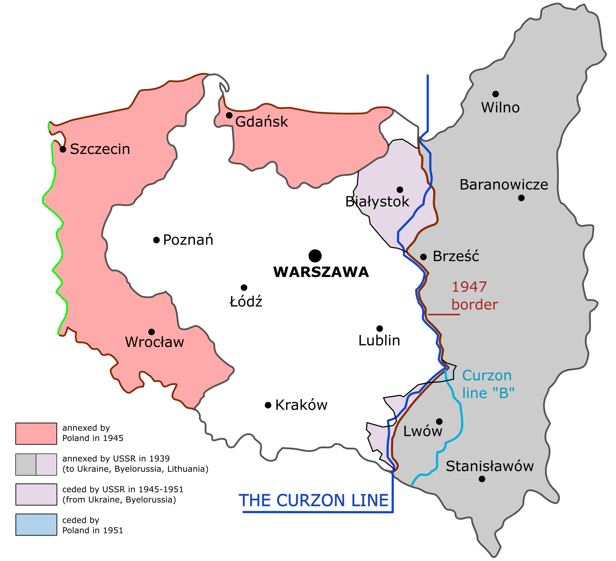
The line became a major geopolitical factor during World War II, when the USSR invaded eastern Poland, resulting in the split of Poland's territory between the USSR and Nazi Germany roughly along the Curzon Line in accordance with final rounds of secret negotiations surrounding the Molotov–Ribbentrop Pact. After the German attack on the Soviet Union in 1941, Operation Barbarossa, the Allies did not agree that Poland's future eastern border should be changed from the pre-war status quo in 1939 until the Tehran Conference. Churchill's position changed after the Soviet victory at the Battle of Kursk.
Following a private agreement at the Tehran Conference, confirmed at the 1945 Yalta Conference, the Allied leaders Franklin Roosevelt, Winston Churchill, and Stalin issued a statement affirming the use of the Curzon Line, with some five-to-eight-kilometre variations, as the eastern border between Poland and the Soviet Union. When Churchill proposed to annex parts of Eastern Galicia, including the city of Lviv, to Poland's territory (following Line B), Stalin argued that the Soviet Union could not demand less territory for itself than the British Government had reconfirmed previously several times. The Allied arrangement involved compensation for this loss via the incorporation of formerly German areas (the so-called Recovered Territories) into Poland. As a result, the current border between Poland and the countries of Belarus and Ukraine is an approximation of the Curzon Line.
At the end of World War I, the Second Polish Republic reclaimed its sovereignty following the disintegration of the occupying forces of three neighbouring empires. Imperial Russia was amid the Russian Civil War after the October Revolution, Austria-Hungary split and went into decline, and the German Reich bowed to pressure from the victorious forces of the Allies of World War I. The Allied victors agreed that an independent Polish state should be recreated from territories previously part of the Russian, the Austro-Hungarian and the German empires, after 123 years of upheavals and military partitions by them.
The Supreme War Council tasked the Commission on Polish Affairs with recommending Poland's eastern border, based on spoken language majority, which became later known as the Curzon Line. Their result was created December 8, 1919. The Allies forwarded it as an armistice line several times during the subsequent Polish-Soviet Wars, most notably in a note from the British government to the Soviets signed by Lord Curzon of Kedleston, the British Foreign Secretary. Both parties disregarded the line when the military situation lay in their favour, and it did not play a role in establishing the Polish–Soviet border in 1921. Instead, the final Peace of Riga (or Treaty of Riga) provided Poland with almost 135,000 square kilometres (52,000 sq mi) of land that was, on average, about 250 kilometres (160 mi) east of the Curzon Line.
The Northern half of the Curzon Line lay approximately along the border which was established between the Kingdom of Prussia and the Russian Empire in 1797, after the Third Partition of Poland, which was the last border recognised by the United Kingdom. Along most of its length, the line at least in principle was intended to follow a generally ethnic or ethnolinguistic boundary - areas West of the line generally contained an overall Polish majority while areas to its East less so- borderland areas were inhabited by Ukrainians, Belarusians, Poles, Jews and Lithuanians. Its 1920 northern extension into Lithuania divided the area disputed between Poland and Lithuania. There were two versions of the southern portion of the line: "A" and "B". Version "B" allocated Lwów (Lviv) to Poland.
The US President Woodrow Wilson's Fourteen Points included the statement "An independent Polish state should be erected which should include the territories inhabited by indisputably Polish populations, which should be assured a free and secure access to the sea..." Article 87 of the Versailles Treaty stipulated that "The boundaries of Poland not laid down in the present Treaty will be subsequently determined by the Principal Allied and Associated Powers." In accordance with these declarations, the Supreme War Council tasked the Commission on Polish Affairs with proposing Poland's eastern boundaries in lands that were inhabited by a mixed population of Poles, Lithuanians, Ukrainians and Belarusians. The Commission issued its recommendation on 22 April; its proposed Russo-Polish borders were close to those of the 19th-century Congress Poland.
The Supreme Council continued to debate the issue for several months. On 8 December, the Council published a map and description of the line along with an announcement that it recognized "Poland's right to organize a regular administration of the territories of the former Russian Empire situated to the West of the line described below." At the same time, the announcement stated the Council was not "...prejudging the provisions which must in the future define the eastern frontiers of Poland" and that "the rights that Poland may be able to establish over the territories situated to the East of the said line are expressly reserved." The announcement had no immediate impact, although the Allies recommended its consideration in an August 1919 proposal to Poland, which was ignored.
Curzon Line
The Curzon Line was a proposed demarcation line between the Second Polish Republic and the Soviet Union, two new states emerging after World War I. Based on a suggestion by Herbert James Paton, it was first proposed in 1919 by Lord Curzon, the British Foreign Secretary, to the Supreme War Council as a diplomatic basis for a future border agreement.
The line became a major geopolitical factor during World War II, when the USSR invaded eastern Poland, resulting in the split of Poland's territory between the USSR and Nazi Germany roughly along the Curzon Line in accordance with final rounds of secret negotiations surrounding the Molotov–Ribbentrop Pact. After the German attack on the Soviet Union in 1941, Operation Barbarossa, the Allies did not agree that Poland's future eastern border should be changed from the pre-war status quo in 1939 until the Tehran Conference. Churchill's position changed after the Soviet victory at the Battle of Kursk.
Following a private agreement at the Tehran Conference, confirmed at the 1945 Yalta Conference, the Allied leaders Franklin Roosevelt, Winston Churchill, and Stalin issued a statement affirming the use of the Curzon Line, with some five-to-eight-kilometre variations, as the eastern border between Poland and the Soviet Union. When Churchill proposed to annex parts of Eastern Galicia, including the city of Lviv, to Poland's territory (following Line B), Stalin argued that the Soviet Union could not demand less territory for itself than the British Government had reconfirmed previously several times. The Allied arrangement involved compensation for this loss via the incorporation of formerly German areas (the so-called Recovered Territories) into Poland. As a result, the current border between Poland and the countries of Belarus and Ukraine is an approximation of the Curzon Line.
At the end of World War I, the Second Polish Republic reclaimed its sovereignty following the disintegration of the occupying forces of three neighbouring empires. Imperial Russia was amid the Russian Civil War after the October Revolution, Austria-Hungary split and went into decline, and the German Reich bowed to pressure from the victorious forces of the Allies of World War I. The Allied victors agreed that an independent Polish state should be recreated from territories previously part of the Russian, the Austro-Hungarian and the German empires, after 123 years of upheavals and military partitions by them.
The Supreme War Council tasked the Commission on Polish Affairs with recommending Poland's eastern border, based on spoken language majority, which became later known as the Curzon Line. Their result was created December 8, 1919. The Allies forwarded it as an armistice line several times during the subsequent Polish-Soviet Wars, most notably in a note from the British government to the Soviets signed by Lord Curzon of Kedleston, the British Foreign Secretary. Both parties disregarded the line when the military situation lay in their favour, and it did not play a role in establishing the Polish–Soviet border in 1921. Instead, the final Peace of Riga (or Treaty of Riga) provided Poland with almost 135,000 square kilometres (52,000 sq mi) of land that was, on average, about 250 kilometres (160 mi) east of the Curzon Line.
The Northern half of the Curzon Line lay approximately along the border which was established between the Kingdom of Prussia and the Russian Empire in 1797, after the Third Partition of Poland, which was the last border recognised by the United Kingdom. Along most of its length, the line at least in principle was intended to follow a generally ethnic or ethnolinguistic boundary - areas West of the line generally contained an overall Polish majority while areas to its East less so- borderland areas were inhabited by Ukrainians, Belarusians, Poles, Jews and Lithuanians. Its 1920 northern extension into Lithuania divided the area disputed between Poland and Lithuania. There were two versions of the southern portion of the line: "A" and "B". Version "B" allocated Lwów (Lviv) to Poland.
The US President Woodrow Wilson's Fourteen Points included the statement "An independent Polish state should be erected which should include the territories inhabited by indisputably Polish populations, which should be assured a free and secure access to the sea..." Article 87 of the Versailles Treaty stipulated that "The boundaries of Poland not laid down in the present Treaty will be subsequently determined by the Principal Allied and Associated Powers." In accordance with these declarations, the Supreme War Council tasked the Commission on Polish Affairs with proposing Poland's eastern boundaries in lands that were inhabited by a mixed population of Poles, Lithuanians, Ukrainians and Belarusians. The Commission issued its recommendation on 22 April; its proposed Russo-Polish borders were close to those of the 19th-century Congress Poland.
The Supreme Council continued to debate the issue for several months. On 8 December, the Council published a map and description of the line along with an announcement that it recognized "Poland's right to organize a regular administration of the territories of the former Russian Empire situated to the West of the line described below." At the same time, the announcement stated the Council was not "...prejudging the provisions which must in the future define the eastern frontiers of Poland" and that "the rights that Poland may be able to establish over the territories situated to the East of the said line are expressly reserved." The announcement had no immediate impact, although the Allies recommended its consideration in an August 1919 proposal to Poland, which was ignored.
Recent media
Recent media