You can help expand this article with text translated from the corresponding article in Spanish. (October 2019) Click [show] for important translation instructions.
|
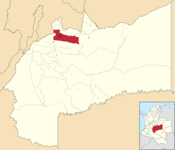
Meta Department (Spanish pronunciation: [ˈmeta]) is one of the 32 departments that compose the Republic of Colombia. Largely located within the country's Orinoquía natural region and covered by the Llanos, it is close to the geographic center of the country, east of the Andes mountains. Its capital is the city of Villavicencio.
Meta was established as a department on 1 July 1960.[4]
Meta was a department particularly effected by the violence of the Colombian conflict,[5] with large areas being under the control of the FARC before the 2016 peace deal.[6]
In May 2021, flooding effected over 5,400 people and 1,100 homes in the department when the Meta River to 8.73 metres (28.6 ft).[7]
Meta Department is close to the geographic center of Colombia, largely located within the country's Orinoquía natural region.[8] It is east of the Andes mountains. A significant portion of the department is a part of the Llanos, a grassland plain. The homonymous Meta River forms the northeastern border.[9] It is bordered by Cundinamarca, Casanare, Vichada, Caquetá, Guaviare, and Huila Departments.[10]
Parts of Chiribiquete Park, Tinigua National Natural Park, La Macarena National Natural Park,[11] and Caño Cristales are located in the department.[12][6]
It has an area of 85,635 square kilometres (33,064 sq mi), 7.49% of the country.[10]
Meta Department is composed of 29 municipalities across 4 subregions. Its capital city is Villavicencio.[13]
| Ariari | Villavicencio | Piedemonte | Meta River |
|---|---|---|---|
 |
 |
 |
 |
| El Castillo • El Dorado • Fuente de Oro • Granada • La Uribe • Lejanías • Mapiripán • Mesetas • Puerto Concordia • Puerto Lleras • Puerto Rico • San Juan de Arama • Vista Hermosa | Villavicencio | Acacías • Barranca de Upía • Castilla la Nueva • Cubarral • Cumaral • El Calvario • Guamal • Restrepo • San Carlos de Guaroa • San Juanito • San Martín | Cabuyaro • La Macarena • Puerto Gaitán • Puerto López |
As of the 2018 Colombian census, Meta Department had a total population of 1,039,722 people.[1] In 2022, it had a Human Development Index of 0.769.[3]
The indigenous Sikuani,[14][15] Jiw,[16] Guayupe peoples are among those who inhabit the department.
| Year | Pop. | ±% |
|---|---|---|
| 1973 | 242,664 | — |
| 1985 | 474,046 | +95.4% |
| 1993 | 618,427 | +30.5% |
| 2005 | 783,168 | +26.6% |
| 2018 | 1,039,722 | +32.8% |
| Source:[17] | ||
Achagua, which is similar to Piapoco, is an Indigenous language spoken by a minority in the department.[18]
Like all departments in Colombia, Meta has a Governor and a Departmental Assembly.[19]
Historically, the department's economy has been dependent on oil and gas. In the early 2020s, the national and departmental government began an effort to focus on and invest in tourism centered around its natural attractions.[6]
In 2022, Meta Department had a GDP of 58,439.5 billion Colombian pesos.[2]
The flag of Meta has 17 horizontal stripes (nine green, eight white), representing Meta's place as the seventeenth department created in Colombia.[20]
The department has a monument marking the exact geographic center of Colombia, in a place known as Alto de Menegua, a few kilometers from Puerto López.[21]