

Community hub
Recent from talks
Contribute something
Nothing was collected or created yet.
Cape Dezhnyov
View on WikipediaThis article includes a list of general references, but it lacks sufficient corresponding inline citations. (March 2013) |

Key Information


Cape Dezhnyov or Cape Dezhnev (Russian: мыс Дежнёва; Eskimo–Aleut: Tugnehalha; Inupiaq: Nuuġaq),[1] formerly known as East Cape or Cape Vostochny, is a cape that forms the easternmost mainland point of Asia. It is located on the Chukchi Peninsula in the very sparsely populated Chukotka Autonomous Okrug of Russia. This cape is located between the Chukchi Sea and the Bering Strait, 82 kilometres (51 mi) across from Cape Prince of Wales in Alaska; the Bering Strait is delimited by the two capes. The Diomede Islands and Fairway Rock are located in the midst of the strait.[2]
Geography
[edit]In 1898, the cape was officially renamed as Cape Dezhnev, replacing Captain James Cook's name, the "East Cape". It was named in honor of Semyon Dezhnev, the first recorded European to round its tip (in 1648). There is a large monument to Dezhnev on the seacoast.
The cape is the eastern tip of a high, rocky headland, about 20 kilometres (12 mi) from Uelen in the north to Cape Pe'ek in the south, connected to the mainland by a neck of lower-lying land peppered with swamps and shallow lakes. That low-lying land is so low in elevation that the cape appears as an island from a distance far to the south of it. The US Hydrographic Office publication Asiatic Pilot from 1909 gives the height of the headland as 2,521 feet (768 m), and the US Office of Coast Survey chart of 2000 shows the highest peak at 2,638 feet (804 m). The headland and the neck of low-lying land together form a peninsula. A well-established trail crossed the neck of land behind the headland in pre-historic and historic times, traversed by sleds in the winter and used as a portage in the summer to avoid traversing the strait. This route was important enough that, according to an analysis by linguist Michael Krauss, the Central Siberian Yupik language continued up the coast, un-interrupted by the Naukansky dialect spoken in the village of Naukan on the headland.
The Great Circle distance from Cape Dezhnev to the shore of the Bab-el-Mandeb strait in Yemen is about 10,855 kilometres (6,745 mi), which is the longest land distance of Asia.
History
[edit]
The Cape Dezhnev (or East Cape, as it was then generally called) peninsula was a center for trade between American (and other) whalers and the fur traders and the native Yupik and Chukchi people of the coast in the late 19th and early 20th centuries. In the early years, ships would call at Uelen to trade for furs produced along the Arctic coast. Subsequently, trading stations were established at Uelen and Deshnevo (Keniskun in Chukchi, Kaniskak in Yupik). When a source of that period speaks of stopping or trading at East Cape, it can refer to either of these locations or to the Yupik village of Naukan on the southeast shore of the cape, which had less trade because it lacked a good anchorage. Sources from that period sometimes speak of a village called Emma-Town. Although this name may be derived from the nearby Yupik village of Enmitahin (Chukchi for "end of the cliff"), the name appears to refer to Keniskun (where the traders were) or perhaps to both villages together. Of the four historical villages on the cape itself, only Uelen is still inhabited. Naukan was evacuated in 1958 with most of the occupants relocated to Nunyamo near Saint Lawrence Bay, Chukotka, and Keniskun was merged with Uelen a little earlier.
In Josef Bauer's As Far as My Feet Will Carry Me (1955), Cape Deshnev is given as the site of a Gulag lead-mine camp from which German POW Clemens Forell (actual name: Cornelius Rost) escaped in 1949. Later research cast serious doubt on the book's accuracy; at the time of the supposed escape, no Cape Dezhnev Gulag camp lead mine existed.[3]
Gallery
[edit]-
 Cape Dezhnev lighthouse, August 2018
 -
 Cape Dezhnev Lighthouse with Dezhnev Monument
 -
 Cape Dezhnev (Chukotka, Russia) with lighthouse (Dezhnew Monument) and abandoned village Naukan
 -
 Kap Dezhnev, remains of abandoned Naukan village
 -
 Erected whalebones near Naukan
 -
 Old Outpost
 -
 Soviet Ruins
 -
 Abandoned village of Naukan near Cape Dezhnev
 -
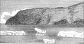 Sketch of Cape Dezhnev from the northeast.
 -
 Chukchi men at Dezhnevo pulling an umiak onto the beach, Cape Dezhnev headland in background, 1913
 -
 View of part of Port Dezhnev, 1913. The American-style cabins near the lagoon are probably a trading station.
 -
 Dezhnev cape erected whalebones


See also
[edit]References
[edit]- ^ Leontiev V.V., Novikova K.A. Toponymic Dictionary of the North-East of the USSR / scientific. ed. G. A. Menovschikov; FEB AN USSR . North-East complex. Research institutes. Lab archeology, history and ethnography. - Magadan: Magad. Prince Publishing House, 1989 .-- p. 130 . - ISBN 5-7581-0044-7
- ^ Cape Dezhnyov, Great Soviet Encyclopedia - Dezhnev Cape, vol. 8, page 25
- ^ "As far as your feet will cary you - A global hit - Fiction and Truth (A four-tape-interview as the basis for the novel)". Bayerischer Rundfunk (Bavarian Broadcasting Company). March 23, 2010. Archived from the original on October 20, 2010. Retrieved December 23, 2011.
General references
[edit]- Bartlett, Robert A. and Hale, Ralph T. (1916). The last voyage of the Karluk : flagship of Vilhjalmar Stefansson's Canadian Arctic Expedition of 1913-16. McClelland, Toronto.
{{cite book}}: CS1 maint: multiple names: authors list (link). - Bockstoce, John R. (2009) Furs and Frontiers in the Far North: The Contest Among Native and Foreign Nations for the Bering Strait Fur Trade The Lamar Series in Western History, Yale University Press, ISBN 0-300-14921-2, ISBN 978-0-300-14921-0
- Cochran, C.S. (1915). "Report of northern cruise, Coast Guard cutter Bear". Annual report of the United States Coast Guard. Washington: Government Printing Office. p. 82.
- Crow, John, Anastasia Yarzuktina, and Oksana Kolomiets "American traders and the native people of Chukotka in the early 20th Century" 2010 International Conference on Russian America, Sitka, AK August 18–22.
- Fisher, Raymond H. (ed) (1981) The Voyage of Semen Dezhnev in 1648: Bering's precursor, with selected documents. Hakluyt Society, London.
- Hodge, Frederick Webb (1912) Handbook of American Indians North of Mexico: A-M Volume 30 of Bulletin (Smithsonian Institution. Bureau of American Ethnology). Part 1 of Handbook of American Indians North of Mexico. (Hodge placed Enmitahin north of East Cape, contrary to the location on the USCGS chart. He reports 48 residents in 8 houses, c. 1895, citing Bogoras).
- Krauss, Michael E. (2005) Eskimo languages in Asia, 1791 on, and the Wrangel Island-Point Hope connection Études/Inuit/Studies, vol. 29 (1-2), 2005, pp 163–185.
- Krupnik, Igor and Mikhail Chlenov (2007). "The end of 'Eskimo land': Yupik relocation in Chukotka, 1958-1959" Études/Inuit/Studies 31 (1-2) pp 59–81.
- Office of Coast Survey. "Bering Sea nautical charts". Historical map and chart project. Office of Coast Survey, NOAA, USA. Archived from the original on December 31, 2010. Retrieved January 10, 2010. Query Bering; select preview for year wanted. Click desired location to enlarge and center.
- Petit Fute (2006). Chukotka. Avant Garde, Moscow. ISBN 5863942584. ISBN 978-5-86394-258-2.
- Rasmussen, Knud. Across Arctic America: Narrative of the Fifth Thule Expedition. New York: G. P. Putnam's Sons, 1927. Scanned, illustrated, at Internet Archive.
- Scull, Edward Marshall (1914). Hunting in the Arctic and Alaska. John C. Winston co.
- United States Hydrographic Office (1909). Asiatic pilot, Volume 1. Issues 122-126; Issue 162 of H.O. pub. Gov. Printing Off., Washington.
External links
[edit]- Cape Dezhnev east of Uelen, showing a Chukchi umiak paddling out to meet the steamer Corwin
- View of Uelen summer 1907
- Trading post at Dezhnevo, late 1920s
| Authority control databases: National |
|---|