Recent from talks
Nothing was collected or created yet.
Uelen
View on WikipediaKey Information

Uelen[a] is a rural locality (a selo) in Chukotsky District, just south of the Arctic Circle in Chukotka Autonomous Okrug in the Russian Far East. As of the 2010 Census, its population was 720.[2][3] Located near Cape Dezhnev where the Bering Sea meets the Chukchi Sea, it is the easternmost settlement in Russia and the whole of Asia. It is located in the Western Hemisphere, but the International Date Line curves around it, so it remains in a Russian time zone (UTC+12:00). Uelen is also the closest Asian settlement to North America. It is on the northeast corner of the Uelen Lagoon, a roughly 15 by 3 kilometres (9 by 2 miles) east-west lagoon separated from the ocean by a sandspit. Municipally, Uelen is subordinated to Chukotsky Municipal District and is incorporated as Uelen Rural Settlement.[5]
History
[edit]Origins of name
[edit]There are a number of competing ideas as to the origin of the name of the village. The name Uelen is thought by some sources to derive from the Chukchi "uvelen" meaning "black, thawed patch", since the village is found at the foot of a hill surrounded by black mounds which are visible throughout the year and were often used as a navigation aid in the region.[11]
There is a local legend which offers a second explanation for the origin of the name. It describes the life of a strong local man called Uvelel'yn (literally translated as "slob"), named so because he was an orphan who was dressed solely in tattered rags. As he grew older, he used his strength to gain his revenge over the local people that bullied him during his childhood because of his background. In fear for their lives, the villagers killed Uvelel'yn. However they realised that in order to prevent these events repeating themselves in the future, they should take better care of their orphans and the village soon got its name to remind the villagers of their duty to those less fortunate than themselves.[11]
Prior to being named Uelen, the village was called Ulyk (Russian: Улык,[12] Olyk in Yupik[12] and Pok’ytkyn in Chukchi),[12] meaning land's end and flooded place respectively.[12]
The first mention of the name Uelen appears on a map from the Billings-Sarychev expedition from 1792.[12]
Prehistory
[edit]Archeological investigation has revealed the existence of a settlement in and around the present day site of the village about 30 km (19 mi) from the village for at least 2000 years,[11] based on fishing and the hunting of marine mammals. The main site of archeological investigation is at the Ekven site, a site of importance comparable to that of the Ipiutak site across the Bering Strait on Point Hope.[13]
Pre-Soviet
[edit]
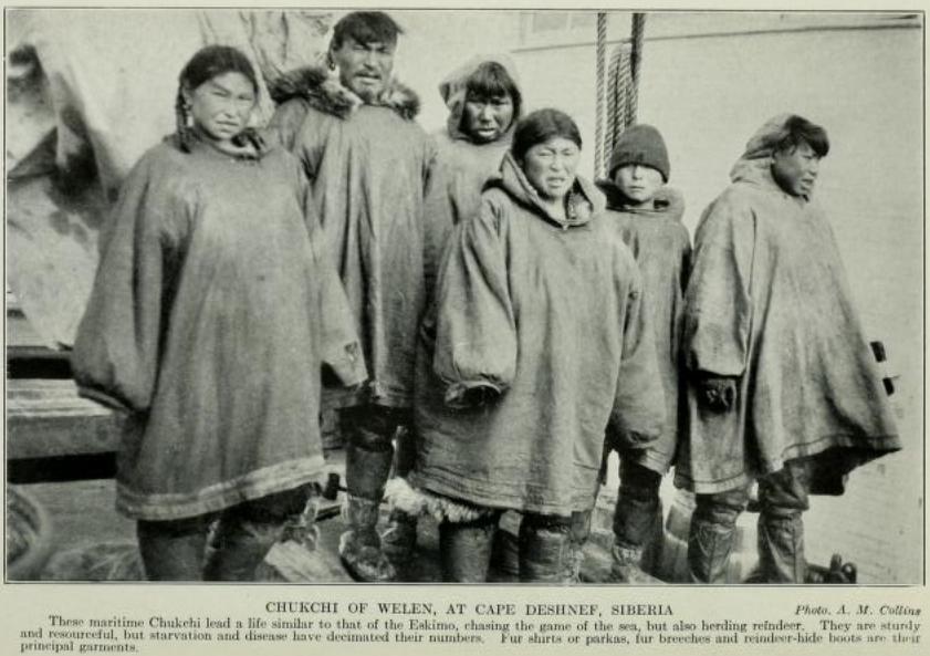
Prior to the Russian Revolution, Uelen was, in 1912, a settlement of around 300 individuals divided into four communes and the headquarters of the Russian administration in the Chukotka Region ("Uyezd") and was an important trading port with both local Russian people and America.[11]
Soviet Union
[edit]Following the Russian Revolution of 1917, Uelen became one of the first trade co-operatives in Chukotka[11] and a dedicated American trading post was established. The first school in Chukotka was established in Uelen in 1916.[14]
In the first half of the twentieth century, Uelen was the site of one of the first Russian arctic research stations.[11]
In the 1950s, Uelen became a focal point in the region, along with Lavrentiya, Lorino and Inchoun (see diagram) for the relocation of indigenous peoples following the decision to close a large number of uneconomical villages. Uelen absorbed the population from the nearby village of Dezhnevo (named, like the neighbouring cape, after the explorer Semyon Dezhnev). This village, to the west of Cape Peek[15] and called Keniskun by the local Chukchi was an important regional coastal trading centre in the late 19th and early 20th centuries, but was deemed unviable by the Soviet government and the villagers were moved to Uelen. The addition of Dezhnevo carvers to the existing artistic school in Uelen served to strengthen Uelen's cultural reputation not just in the region but across Russia with notable carvers such as Pyotr Penkok and Stepan Ettugi working in Uelen.[11] In addition to absorbing the population of Dezhnevo, Uelen also absorbed the part of the population of the former village of Naukan,[16] which itself had absorbed the population of a number of small villages from the Cape Dezhnev/Diomede Islands area.[16]
Post-Soviet
[edit]


Although Dezhnevo was officially abolished, the villagers in Uelen still use it as a base for their fishing and a handful of houses are still maintained for this purpose. As well as a fishing base, the site of the village is still used as an occasional port by Uelen. At the end of summer, storms in the Chukchi Sea can make it impossible for ships to dock at Uelen to unload their supplies. When this occurs, the ships dock at Dezhnevo and the cargo is carried across land to Uelen.[11]
In more recent history, Uelen is where Dimitri Kieffer and Karl Bushby entered Russia during their Goliath Expedition after crossing the Bering Strait. The two were then arrested because they had failed to enter the country at a proper port of entry, but their journey was allowed to continue.[17]
Demographics
[edit]The population according to the most recent census results was 740,[2] of whom 368 were male and 352 female.[3] Uelen had a population of 740 at the start of 2009, down from 776 in 2003 (with 595 Chukchi and 72 Yupik.[18]) Other villagers are Russian.[18]
Culture
[edit]The village is famous for its walrus ivory carvings. It has long been a major artistic centre in the region, with Several of the leading exponents of the craft, such as Vukvutagin, Vukvol, Tukkai and Khukhutan working out of Uelen.[18] The Uelen Bone Carving Studio (Russian: Уэленская косторезная мастерская) contains the world's only museum of Walrus ivory carving.[14] In 2004, a successful exhibition of their work was held in Bern, Switzerland[14] and carvers from Uelen took first place in the category Russian hunt: Tradition and Modernity at the third Moscow Exhibition of Russian Crafts.[14]
It is also home to an indigenous choir which has a history of cultural collaboration with Inuit across the Bering Strait in Alaska.[18]
The writer Yuri Rytkheu was born in Uelen on March 8, 1930, to a family of trappers and hunters. He was the first Chukchi author to achieve national prominence. His book A Dream in Polar Fog deals with the Chukchi people's efforts to adapt when a foreigner is shipwrecked on their shores.[19]
The village also serves as a base for archaeology expeditions to the area, which have uncovered a burial ground containing more than 300 burials of Early Whale Hunter cultures, covering a time span from 500 BCE to 1000 CE. These excavations have shown that Uelen was a major settlement in the area in the first few centuries CE, as well as revealing the existence of a culture dependent on whale and walrus hunting, archeologists have also unearthed early examples of the indigenous peoples ivory carvings, a number of which are now held at the Peter the Great Museum of Anthropology and Ethnography in St. Petersburg.[11]
Transport
[edit]Uelen is not connected by road to any other part of the world and is 100 km from the district centre, Lavrentiya.[14] However, there is a small network of roads in the village including:[20]
Climate
[edit]Uelen has a tundra climate (Köppen ET). Chukotsky district endures extreme Arctic weather, with an average winter low of −22 °C (−7.6 °F)[21] in January, though Uelen's average January temperature is slightly higher at −19 °C (−2.2 °F). February is the coldest month. The average July temperature is slightly higher at +5.9 °C (42.6 °F) than the district average for the month of +5.4 °C (41.7 °F),[21] and the overall annual average of −6.7 °C (19.9 °F) is also higher than the district average of −8.2 °C (17.2 °F).[21] Snow storms in the winter from the north cause harsh frosts and drifting snow, whilst southerly blizzards bring large snowfalls and sudden thaws.[21] The area is also very windy, reaching 35 m/s (68 kn) annually and 50 m/s (97 kn) every two decades.[21] Spring weather is a little milder than winter weather if still below freezing.[21] Due to the position of Uelen by the sea coast there are also many instances of fog and mist per year[21] with the result that sunshine hours are very low especially when the adjacent ocean begins to thaw. The record high is +25.0 °C (77.0 °F) on July 16, 1960, and the record low is −44.1 °C (−47.4 °F) on January 29, 1989.
| Climate data for Uelen (1991–2020 normals) | |||||||||||||
|---|---|---|---|---|---|---|---|---|---|---|---|---|---|
| Month | Jan | Feb | Mar | Apr | May | Jun | Jul | Aug | Sep | Oct | Nov | Dec | Year |
| Record high °C (°F) | 6.1 (43.0) |
5.6 (42.1) |
4.3 (39.7) |
8.9 (48.0) |
10.8 (51.4) |
22.1 (71.8) |
25.0 (77.0) |
22.0 (71.6) |
16.3 (61.3) |
14.2 (57.6) |
9.0 (48.2) |
10.0 (50.0) |
25.0 (77.0) |
| Mean daily maximum °C (°F) | −16.5 (2.3) |
−16.0 (3.2) |
−15.0 (5.0) |
−8.6 (16.5) |
−0.3 (31.5) |
6.2 (43.2) |
10.3 (50.5) |
9.3 (48.7) |
5.9 (42.6) |
1.6 (34.9) |
−3.6 (25.5) |
−11.7 (10.9) |
−3.2 (26.2) |
| Daily mean °C (°F) | −19.5 (−3.1) |
−19.2 (−2.6) |
−18.5 (−1.3) |
−11.8 (10.8) |
−2.5 (27.5) |
3.3 (37.9) |
7.1 (44.8) |
6.9 (44.4) |
4.2 (39.6) |
−0.1 (31.8) |
−6.0 (21.2) |
−14.3 (6.3) |
−5.9 (21.4) |
| Mean daily minimum °C (°F) | −22.6 (−8.7) |
−22.4 (−8.3) |
−21.9 (−7.4) |
−15.0 (5.0) |
−4.5 (23.9) |
1.2 (34.2) |
4.6 (40.3) |
4.9 (40.8) |
2.6 (36.7) |
−1.8 (28.8) |
−8.7 (16.3) |
−17.2 (1.0) |
−8.4 (16.9) |
| Record low °C (°F) | −44.1 (−47.4) |
−43.2 (−45.8) |
−43.6 (−46.5) |
−37.2 (−35.0) |
−25.0 (−13.0) |
−10.0 (14.0) |
−1.6 (29.1) |
−2.2 (28.0) |
−7.8 (18.0) |
−22.0 (−7.6) |
−34.0 (−29.2) |
−41.1 (−42.0) |
−44.1 (−47.4) |
| Average precipitation mm (inches) | 18.6 (0.73) |
18.2 (0.72) |
12.3 (0.48) |
15.2 (0.60) |
13.9 (0.55) |
14.2 (0.56) |
31.7 (1.25) |
42.5 (1.67) |
36.1 (1.42) |
43.3 (1.70) |
22.9 (0.90) |
19.5 (0.77) |
288.4 (11.35) |
| Average rainy days | 0.03 | 1 | 0.1 | 1 | 4 | 10 | 15 | 18 | 18 | 9 | 2 | 1 | 59.13 |
| Average snowy days | 16 | 15 | 18 | 14 | 16 | 5 | 1 | 1 | 7 | 21 | 23 | 18 | 155 |
| Average relative humidity (%) | 82 | 80 | 81 | 83 | 88 | 89 | 89 | 90 | 88 | 86 | 84 | 84 | 85 |
| Mean monthly sunshine hours | 3.1 | 62.1 | 161.2 | 186.0 | 148.8 | 204.0 | 201.5 | 117.8 | 66.0 | 24.8 | 15.0 | 0.0 | 1,190.3 |
| Source 1: Roshydromet[22] | |||||||||||||
| Source 2: allmetsat.com (sunshine hours)[23] | |||||||||||||
See also
[edit]Notes
[edit]- ^ Russian: Уэлéн; Chukchi: Увэлен, Uvèlèn; Siberian Yupik: Улыӄ, Ulyḳ; Naukan Yupik: Олыӄ, Oleq;[9] Iñupiaq: Ualeq[10]; also known as Whalen in older English-language sources and Ugelen on United States Coast and Geodetic Survey charts
References
[edit]- ^ a b c Law #33-OZ, Article 13.2 (in Russian)
- ^ a b c Russian Federal State Statistics Service (2011). Всероссийская перепись населения 2010 года. Том 1 [2010 All-Russian Population Census, vol. 1]. Всероссийская перепись населения 2010 года [2010 All-Russia Population Census] (in Russian). Federal State Statistics Service.
- ^ a b c The results of the 2010 Census are given for Uelen Rural Settlement, a municipal formation of Chukotsky Municipal District. According to Law #148-OZ, Uelen is the only inhabited locality on the territory of Uelen Rural Settlement.
- ^ Office of the Federal State Statistics Service for Khabarovsk Krai, Magadan Oblast, Jewish Autonomous Oblast and Chukotka Autonomous Okrug. Численность населения Чукотского автономного округа по муниципальным образованиям на 1 января 2018 года Archived 2019-08-31 at the Wayback Machine (in Russian)
- ^ a b c d Law #47-OZ, Article 6 (in Russian)
- ^ "Об исчислении времени". Официальный интернет-портал правовой информации (in Russian). 3 June 2011. Retrieved 19 January 2019.
- ^ Почта России. Информационно-вычислительный центр ОАСУ РПО. (Russian Post). Поиск объектов почтовой связи (Postal Objects Search) (in Russian)
- ^ Ministry of Justice of the Russian Federation Archived 2012-02-08 at the Wayback Machine Chukotsky District (in Russian)
- ^ Меновщиков, Г. А. (1972). Местные названия на карте Чукотки. Краткий топонимический словарь [Local names on the map of Chukotka: The Concise Toponymic Dictionary] (PDF) (in Russian). Magadan: Магаданское книжное издательство. p. 159. Archived from the original (PDF) on 2016-08-04. Retrieved 2018-04-21.
- ^ "Little Diomede Iñupiaq Glossary and Walrus Preparation Guide" (PDF). Kawerak. 2014.
- ^ a b c d e f g h i Strogoff, p.119
- ^ a b c d e Information on Uelen Archived 2012-04-22 at the Wayback Machine, Beringia Nature Park Website. Retrieved 12 April 2012.
- ^ "Arctic Studies Center: Ekven Burial". Archived from the original on 2015-12-26. Retrieved 2009-09-15.
- ^ a b c d e Муниципальное образование сельское поселение Уэлен Archived 2012-09-14 at the Wayback Machine Municipal formation rural settlement of Uelen – Official Chukotsky district website
- ^ NOAA Office of Coast Survey Website[permanent dead link]
- ^ a b Beringian Notes 2.2, Bogoslovaskaya, L., National Park Service, Alaska Region (1993), pp. 1–12
- ^ [1] Dmitri Kieffer's Blog as part of the Goliath Expedition
- ^ a b c d Red Cross Chukotka – Chukotsky District (Archived)
- ^ A Dream in Polar Fog Yuri Rytkheu, trans. by Ilona Yazhbin Chavasse (Archipelago Books, 2006). ISBN 978-0-9778576-1-6
- ^ Uelen- Chukotsky District Archived 2012-04-06 at the Wayback Machine Pochtovik Mail Delivery Service (in Russian)
- ^ a b c d e f g Petit Fute, Chukotka, pp. 112–113
- ^ "Climate of Uelen" (in Russian). Weather and Climate (Погода и климат). Retrieved 1 November 2019.
- ^ "Uelen, Russia". allmetsat.com. Archived from the original on April 1, 2012. Retrieved November 2, 2010.
Sources
[edit]- Дума Чукотского автономного округа. Закон №33-ОЗ от 30 июня 1998 г. «Об административно-территориальном устройстве Чукотского автономного округа», в ред. Закона №55-ОЗ от 9 июня 2012 г. «О внесении изменений в Закон Чукотского автономного округа "Об административно-территориальном устройстве Чукотского автономного округа"». Вступил в силу по истечении десяти дней со дня его официального опубликования. Опубликован: "Ведомости", №7 (28), 14 мая 1999 г. (Duma of Chukotka Autonomous Okrug. Law #33-OZ of June 30, 1998 On the Administrative-Territorial Structure of Chukotka Autonomous Okrug, as amended by the Law #55-OZ of June 9, 2012 On Amending the Law of Chukotka Autonomous Okrug "On the Administrative-Territorial Structure of Chukotka Autonomous Okrug". Effective as of after ten days from the day of the official publication.).
- Дума Чукотского автономного округа. Закон №47-ОЗ от 29 ноября 2004 г. «О статусе, границах и административных центрах муниципальных образований на территории Чукотского района Чукотского автономного округа». Вступил в силу через десять дней со дня официального опубликования. Опубликован: "Ведомости", №31/1 (178/1), 10 декабря 2004 г. (Duma of Chukotka Autonomous Okrug. Law #47-OZ of November 29, 2004 On the Status, Borders, and Administrative Centers of the Municipal Formations on the Territory of Chukotsky District of Chukotka Autonomous Okrug. Effective as of the day which is ten days after the official publication date.).
- Strogoff, M, Brochet, P-C and Auzias, D. Petit Futé: Chukotka, "Avant-Garde" Publishing House, 2006.
External links
[edit]- Krupnik, Igor and Mikhail Chlenov (2007). The end of “Eskimo land”: Yupik relocation in Chukotka, 1958–1959 Études/Inuit/Studies 31 (1–2) pp 59–81. Includes some material on Dezhnevo relocation.
- Aerial photo of Uelen Archived 2011-10-09 at the Wayback Machine
- Photo gallery of Uelen
Uelen
View on GrokipediaGeography
Location and Significance
Uelen is a rural settlement in Chukotsky District of Chukotka Autonomous Okrug, located in the northeastern extremity of the Chukchi Peninsula in Russia's Far East, at approximately 66°10′N 169°50′W. Positioned just south of the Arctic Circle, it lies adjacent to Cape Dezhnev, the easternmost point of mainland Asia, where the Chukchi Sea meets the Bering Sea.[6][7] This positioning renders Uelen the easternmost inhabited locality in Russia and Eurasia, situated roughly 82 kilometers across the Bering Strait from the Alaskan mainland at the strait’s narrowest point.[8] Its proximity to North America has historically facilitated cultural exchanges between indigenous peoples on both continents, while underscoring its isolation amid tundra and permafrost environments.[9] Geographically, Uelen's significance extends to its role as a vantage for observing the convergence of Arctic maritime routes and as a hub for traditional Chukchi activities, including marine mammal hunting. The settlement also hosts key archaeological sites, such as the Uelen burial ground, which contains extensive prehistoric artifacts illuminating ancient Beringian cultures.[2]Physical Features
Uelen is positioned on a low coastal plain at the northeastern tip of the Chukchi Peninsula, with geographic coordinates of approximately 66°10′N 169°50′W.[7][6] The terrain features tundra landscapes with continuous permafrost underlying the thin active layer, characteristic of eastern Chukotka's coastal lowlands framed by low-mountain ranges.[6][10] Elevations in the settlement average 14 meters above sea level, facilitating its exposure to marine influences from the adjacent Chukchi Sea and Bering Strait.[11] Proximate to Uelen, about 20 kilometers east, lies Cape Dezhnev, a rugged, cliff-lined promontory that forms Eurasia's easternmost extremity and rises to a massif height of 740 meters, separating the two seas.[12][13] The surrounding area exhibits sparse vegetation dominated by mosses, lichens, and dwarf shrubs adapted to the permafrost-constrained soils and short growing season.[10] The region experiences a polar tundra climate, marked by extreme seasonal temperature variations and limited precipitation. Average monthly temperatures range from -23.7°C in January to +10.6°C in July across Chukotka, with Uelen's coastal location providing marginal moderation against interior extremes.[14] Annual precipitation totals approximately 150-200 mm in northern coastal zones, predominantly as snow, contributing to persistent ice cover and minimal surface runoff due to frozen ground.[15] Permafrost thickness in eastern Chukotka's lowlands often exceeds 200 meters, with a transient thaw layer varying seasonally and influencing landscape stability.[16]History
Etymology and Origins
The name Uelen derives from the Chukchi term uvэlen (or uvelen), meaning "black thawed patch" or "black earth," referring to the dark soil exposed early in spring at the base of the nearby hill where snow melts first.[17] This etymology reflects the local tundra landscape's seasonal characteristics, with the Russian form Uelen adapting the indigenous pronunciation.[18] Historical records indicate earlier designations for the site, including the Russian Ulyk and indigenous variants such as Yupik Olyk ("the land's end," alluding to its position near Cape Dezhnev) and Chukchi Pok'ytkyn ("flooded place," possibly denoting seasonal flooding or coastal exposure).[2] These names underscore the settlement's longstanding significance as a peripheral outpost in Chukchi and Yupik cultural geography, predating formalized Russian usage of Uelen in official mappings from the 19th century onward.[2]Prehistoric and Archaeological Evidence
The Uelen cemetery, excavated starting in 1955 by D. A. Sergeev, contains artifacts and burials primarily from the first millennium A.D., reflecting the presence of ancient Asiatic Eskimo populations skilled in sea mammal hunting, including both Eskimos and possibly early Chukchi migrants who adopted maritime practices.[19][20] These findings indicate continuous human occupation tied to whaling and coastal adaptation, with grave goods such as ivory carvings demonstrating cultural continuity in artistic traditions.[4] Adjacent to Uelen, the Ekven site represents one of the most significant archaeological complexes in Chukotka, featuring a multi-layered burial ground and associated settlement dating from approximately 500 BCE to 1000 CE, comparable in scale to the Ipiutak site across the Bering Strait.[21] Excavations, conducted jointly by the State Museum of Oriental Art and the University of Tübingen, have uncovered evidence of semi-permanent dwellings built with driftwood frames, sod walls, and whale bones, alongside complex burial practices including status-reflecting grave goods like engraved ivory and bone tools linked to the Old Bering Sea culture.[21][22] Genomic analysis of ancient individuals from Chukotka sites, including those near Uelen, confirms Paleo-Eskimo ancestry with genetic continuity to later Inuit groups, supporting archaeological evidence of enduring coastal hunter-gatherer societies adapted to Bering Strait environments.[22] Paleophenetic studies of cranial remains from prehistoric coastal Chukotka populations, including Uelen-area samples, reveal nonmetric traits consistent with adaptation to Arctic maritime lifestyles over millennia, with minimal disruption until later periods.[23] These sites underscore Uelen's role as a key node in ancient Beringian networks, where evidence of whaling technology and ritual practices predates recorded history by over two millennia.[3]Pre-Soviet Period
During the late Tsarist period, Uelen functioned as a key sedentary settlement for coastal Chukchi (Ankalyn), who specialized in sea mammal hunting, distinguishing them from inland reindeer-herding Chukchi (Chauchu).[24] The community maintained semi-independence from Russian authorities under the 1822 Law, which classified Chukchi as a separate category with limited obligations, reflecting the empire's inability to fully subdue them despite earlier military campaigns in the 18th and 19th centuries.[24] Russian presence remained minimal, consisting of only a dozen or so Cossacks and functionaries overseeing tribute (iasak) collection, primarily furs and ivory, while avoiding deeper administrative control due to harsh conditions and native resistance.[24] By the early 20th century, peace had been established between local Chukchi and Russian officials, enabling stable but peripheral interactions.[25] Trade dominated Uelen's external relations, with American whalers and merchants from Alaska exerting greater influence than Russians after the decline of imperial whaling fleets.[24] Natives exchanged walrus ivory, furs, and marine products for firearms, food, tobacco, and manufactured goods, positioning Uelen as a coastal trade hub.[24] Local elites, including shamans and skilled traders, facilitated these exchanges; for instance, figures like Frank, a Luoravetlan shaman from Uelen, engaged in transcontinental activities, including work in San Francisco.[24] Gold prospecting expeditions in the 1900s further elevated the settlement's role in regional commerce.[24] Russian Orthodox missionaries made limited inroads in the late 19th century, introducing Christianity among some Chukchi, though traditional practices persisted dominantly.[26] In 1912, Uelen comprised approximately 300 residents organized into four communes, underscoring its communal structure amid a predominantly indigenous population with negligible Russian settlement.[3] This era preserved Chukchi autonomy in subsistence—relying on whaling, sealing, and walrus hunting—while integrating selective foreign goods into daily life, setting the stage for post-revolutionary changes.[24]Soviet Era
Following the Russian Revolution, Uelen emerged as an early center of Soviet administrative organization in Chukotka, with the settlement designated a key power base by 1920. In 1927, Soviet emissaries arrived to establish Native Councils along the north coast, organizing local elections in Uelen where Matliu was elected council president; these bodies aimed to promote equitable resource distribution, suppress shamanism, and form work brigades or artels that transitioned production from family units to collective operations, including provision of long-term credit for hunting equipment.[27][24] Collectivization policies took hold in the 1930s, with the first kolkhozes (collective farms) formed among maritime Chukchi hunters, compelling sedentarization and integration into state-controlled hunting and production units, though full incorporation of Chukotka's indigenous economies extended into the 1950s.[4][24] Uelen's coastal economy, centered on walrus and whale hunting, adapted through these collectives, which restricted prior American trade influences established post-1917.[24] In 1931, residents initiated Chukotka's first ivory carving workshop under Tegrynkeu, directed by Vukvutagin and featuring initial carvers Aie, Aromke, and Khal’mo; the enterprise expanded in the mid-1930s with artists like Vukvol and Tukkai, supported by Soviet cultural promoters such as Alexander Gorbunkov (1933–1935), who emphasized native motifs and collective creativity, culminating in a 1937 exhibition at Moscow's State Tretyakov Gallery.[4] By the 1950s, under Igor Lavrov's leadership, the workshop received electric tools and shifted toward folklore themes, bolstering its role amid broader Sovietization that closed nearby settlements like Dezhnev and Naukan, relocating their artists to Uelen.[4] World War II disrupted operations, with trade halted and carver Vukvol perishing in the conflict, prompting the workshop's renaming in his honor; a subsequent industrial combine, Uelenskii Promkombinat, collapsed by 1948 due to waning local support.[4] Notable artifacts, such as a Lenin carving on sealskin, elevated Uelen's cultural profile in Moscow, shielding the settlement from potential closure during purges and ideological enforcements.[28]Post-Soviet Period
Following the dissolution of the Soviet Union in 1991, Uelen faced acute economic challenges as state subsidies and supply chains from mainland Russia disintegrated, forcing residents to intensify reliance on traditional subsistence activities such as marine mammal hunting and whaling for survival. Food shortages and unreliable deliveries exacerbated hardships in this remote coastal settlement, mirroring broader trends across Chukotka where the regional economy contracted sharply and infrastructure decayed.[29] The population of Chukotka declined dramatically from approximately 157,000 in the 1989 census to 53,800 by 2002, driven primarily by the emigration of non-indigenous workers, though Uelen's predominantly Chukchi community experienced relative stability through adherence to ancestral practices.[30] In the early 2000s, the appointment of Roman Abramovich as governor of Chukotka Autonomous Okrug marked a turning point, with substantial investments—totaling billions of rubles, including personal funds—directed toward remote villages like Uelen to address wage arrears, enhance food and fuel supplies, and upgrade social services such as schools and healthcare facilities. These efforts improved living conditions, enabling better support for traditional whaling under international aboriginal subsistence quotas allocated by the International Whaling Commission, which permitted Chukotka communities to harvest gray whales for cultural and nutritional needs.[31] [32] [33] Ivory carving, a longstanding craft in Uelen, persisted as an economic supplement, though market access remained limited by the village's isolation.[4] After Abramovich's tenure ended in 2008, Uelen's economy stabilized around mixed subsistence and minimal modern activities, with the Chukotsky District population rising slightly to 4,838 by the 2010 census and 4,995 by 2021, reflecting halted depopulation and modest infrastructure retention. Community life emphasized cultural continuity, including annual whale hunts that reinforce social bonds among Chukchi residents, amid ongoing challenges like climate variability affecting hunting grounds.[34] Despite these adaptations, the settlement's remoteness continues to constrain diversification beyond traditional pursuits.[29]Demographics
Population Dynamics
The population of Uelen has declined gradually since the early 2010s, reflecting broader challenges in Russia's remote Arctic indigenous settlements, including out-migration for education and employment, low fertility rates, and elevated mortality from health issues prevalent among Chukchi communities. According to the 2010 All-Russian Census, the village had 720 residents.[35] By January 1, 2021, official Rosstat estimates reported 599 inhabitants, a decrease of approximately 17% over the decade. This figure fell further to 592 as of January 1, 2022, indicating an annual loss rate of about 1-2% in recent years.| Year | Population | Change from Previous |
|---|---|---|
| 2010 (Census) | 720 | - |
| 2021 (Jan 1) | 599 | -121 (-17%) |
| 2022 (Jan 1) | 592 | -7 (-1.2%) |
