Hubbry Logo
Ems (river)Ems (river)Main
Open search
Ems (river)
Community hub
Ems (river)
logo
8 pages, 0 posts
0 subscribers
Be the first to start a discussion here.
Ems (river)
Ems (river)
from Wikipedia
Ems
Eems (Dutch, Low German), Iems (Westfalian), Oamse (Saterland Frisian), Amisia (Latin)
The Ems near Lingen
River system of the Ems
Map
Location
CountryGermany and Netherlands(part of watershed)
StatesLower Saxony and North Rhine-Westphalia
RegionEmsland
Cities
Physical characteristics
Source 
 • locationSchloß Holte-Stukenbrock
 • coordinates51°51′21″N 8°41′55″E / 51.85583°N 8.69861°E / 51.85583; 8.69861
 • elevation134 m (440 ft)
MouthDollart Bay/North Sea
 • location
Emden
 • coordinates
53°19′32″N 7°14′41″E / 53.32556°N 7.24472°E / 53.32556; 7.24472
 • elevation
0 m (0 ft)
Length362.4 km (225.2 mi)[1]
Basin size17,934 km2 (6,924 sq mi)
Discharge 
 • locationEmden
 • average80 m3/s (2,800 cu ft/s)
Basin features
Tributaries 
 • rightLeda, Hase

The Ems (German: Ems [ɛms] ; Dutch: Eems [eːms] ) is a river in northwestern Germany. It runs through the states of North Rhine-Westphalia and Lower Saxony, and discharges into the Dollart Bay which is part of the Wadden Sea. Its total length is 362.4 kilometres (225.2 mi).[1] The state border between the Lower Saxon area of East Friesland (Germany) and the province of Groningen (Netherlands), whose exact course was the subject of a border dispute between Germany and the Netherlands (settled in 2014), runs through the Ems estuary.

Course

[edit]

The source of the river is in the southern Teutoburg Forest in North Rhine-Westphalia. In Lower Saxony, the brook becomes a comparatively large river. Here the swampy region of Emsland is named after the river. In Meppen the Ems is joined by its largest tributary, the Hase River. It then flows northwards, close to the Dutch border, into East Frisia. Near Emden, it flows into the Dollard bay (a national park) and then continues as a tidal river towards the Dutch city of Delfzijl.

Between Emden and Delfzijl, the Ems forms the border between the Netherlands and Germany and was subject to a mild dispute: the Dutch believed that the border runs through the geographical centre of the estuary, whereas the Germans claimed it runs through the deepest channel (which is close to the Dutch coast). As the parties are now friendly states with an open border, the argument went no further than an agreement to disagree. The issue was settled amicably in October 2014.[2][3]

It became an active issue in late July 1914, when the Imperial German government began plans to mine the whole of the estuary that they claimed, in preparation for the launching of the Great War. The Dutch envoy in Berlin, Wilem Alexander Frederik Baron Gevers, tactfully announced the boundary was uncertain, and that the dispute was "opgeschort", which could mean either "suspended" or "resolved", depending on the context. The Dutch government endorsed the ambiguous declaration, thus relieving itself of an obligation to declare war on Germany for violating its neutrality. After the war, the dispute was resumed.[4]

Past Delfzijl, the Ems discharges into the Wadden Sea, part of the North Sea. The two straits that separate the German island of Borkum from its neighbours Rottumeroog (Netherlands) and Memmert (Germany) continue the name "Ems", as they are called Westere(e)ms and Osterems (West and East Ems).

Tourism

[edit]
The Ems only a few hundred yards from its spring in Schloß Holte-Stukenbrock

The Ems is accompanied and crossed by different long-distance bicycle routes:

Cities and municipalities

[edit]

Tributaries

[edit]

History

[edit]

The Ems was known to several ancient authors: Pliny the Elder in Natural History (4.14), Tacitus in the Annals (Book 1), Pomponius Mela (3.3), Strabo and Ptolemy, Geography (2.10). Ptolemy's name for it was the Amisios potamos, and in Latin Amisius fluvius. The others used the same, or Amisia, or Amasia or Amasios. The identification is certain, as it always is listed between the Rhine and the Weser, and was the only river leading to the Teutoburg Forest.

The Amisius flowed from the Teutoburg Forest, home of the Cherusci, with the Bructeri and others bordering the river. These tribes were among the initial Franks. The Romans were quite interested in adding them to the empire, and to that end built a fort, Amisia, at the mouth of the Ems. As the river was navigable to their ships, they hoped to use it to access the tribes at its upper end.

Surrounding the river for most of its length, however, were swamps, bogs and marshes. The Romans found they had no place to stand, could not pick the most favourable ground, because there was none, and could not in general follow the strategies and tactics developed by the Roman army. They were stopped at the Battle of Teutoburg Forest, 9 AD, and were checked again 6 years later. The Ems became a road leading nowhere for them, nor were they ever able to bridge the swamps satisfactorily with causeways.

The Dollart Bay near Emden did not exist until 1277,[5] when a catastrophic storm surge flooded 43 parishes and killed an estimated 80,000 people.[6] Most of the land lost in that flood has been reclaimed in a series of initiatives from the 16th to the early 20th centuries. The river in 1277 curved north by Emden, covering the area of the current Emden harbor complex.

Construction of canals in more modern times connected the Ems to other waterways, opening it as a highway of industrial transportation.

River islands

[edit]

References

[edit]
[edit]
Revisions and contributorsEdit on WikipediaRead on Wikipedia
from Grokipedia
The Ems is a 371-kilometre-long lowland river in northwestern that originates as a brook in the Senne, a sandy region at the southern foot of the Teutoburger Forest in , and flows generally northwest through the states of and before discharging into the Dollart, a bay of the forming the border with the near . Its spans about 7,300 square kilometres across the , supporting , industry, and in a historically significant region. The river becomes tidal in its lower reaches, influencing estuarine ecology and facilitating shipping via connected canals, though it has experienced hydrological alterations from human interventions such as channel deepening.

Geography

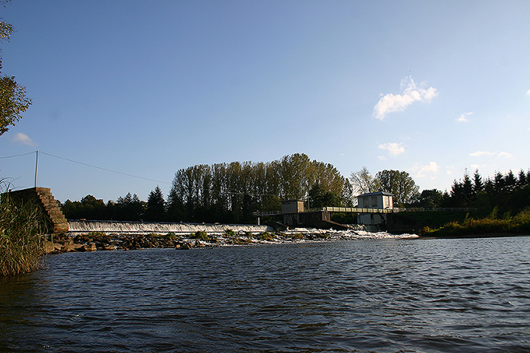
Course and morphology

The Ems originates in the Senne region at the southern foot of the , where multiple small springs unite in a spreading, sandy area near Hövelhof in . From there, it flows generally northwest through the Paderborn Land and Münsterland regions, passing near towns such as Rietberg, Harsewinkel, and . In its upper and middle reaches, the Ems exhibits characteristics of a typical lowland river, featuring a relatively broad valley, meandering course, and low gradient that promotes sediment deposition and gentle bends. Continuing into , the river traverses the Land and districts, flowing past cities including Lingen, , , and Leer before reaching . Its total length measures approximately 371 kilometers, with the lower sections transitioning into a tidal influenced by tides. In the estuarine reach, the channel has been artificially deepened from about 4 meters to 8 meters below high water levels since the 1930s to facilitate , altering natural flow patterns and enhancing tidal propagation upstream. The Ems discharges into the Dollart Bay, a shallow coastal of the that forms part of the Germany-Netherlands border, where the river's morphology shifts to a funnel-shaped with increasing width and depth toward the , reaching up to 20 meters in the outer portions. This estuarine zone is characterized by high loads, flood-dominant , and dynamic bedforms due to interplay between river discharge and tidal currents.

River basin and tributaries

The Ems River basin drains an area of approximately 18,000 km², primarily in northwestern and northeastern . About 84% of this area lies in , with 23% in and 61% in , while 13% is in the Netherlands and 3% falls within the international Ems-Dollart estuary. The basin extends from the southern uplands, where the river originates at an elevation of around 490 m above sea level, through the flat characterized by agricultural lands, moors, and peat bogs toward the . The most significant tributaries are the Hase and Leda rivers. The Hase, the largest , joins the Ems from the right at in after flowing 170 km eastward from its source near . The Leda, a tidal , enters the Ems at Leer, formed by the of the Börger and Sater rivers approximately 40 km upstream, with a total length from sources of about 72 km. In the Dutch portion, the Westerwoldse Aa represents the primary , discharging into the Dollart Bay. Smaller upper tributaries, such as the Werse, Bever, and Hessel, contribute to the Ems in its middle reaches near and Telgte, draining local agricultural and urban areas in . These tributaries collectively enhance the river's flow regime, with the Hase providing the bulk of upstream discharge before the lower tidal influences dominate. The basin's reflects a transition from permeable sandy soils in the south to impermeable clays and peats in the north, influencing infiltration and runoff patterns.

Hydrology

Discharge characteristics

The discharge of the Ems River is primarily characterized by measurements at the Versen gauging station (Pegel Versen-Wehrdurchstich), situated at river kilometer 234.78, about 40 km upstream of the tidal influence near Herbrum. The long-term mean annual discharge (MQ), calculated from daily averages spanning 1941 to 2018, stands at 79.1 cubic meters per second (m³/s). Extreme discharges highlight the river's variability: the lowest recorded value (NNQ) was 5.2 m³/s on August 1, 1947, with a mean low-water discharge (MNQ) of 17.5 m³/s and a seven-day mean low-water discharge (NM7Q) of 6.13 m³/s during September 9–15, 1947. The highest recorded discharge (HHQ) reached 1,200 m³/s on February 12, 1946, while the mean high-water discharge (MHQ) averages 356 m³/s. Seasonal patterns reflect precipitation-driven runoff in the predominantly agricultural and forested basin, with high-water phases dominating from December to March and low-water periods from June to October; summer flows are roughly 2.5 times lower than winter averages. This regime contributes to occasional peak events exceeding 1,000 m³/s, influenced by winter storms and , though sustained high discharges remain moderated by the river's canalized lower course and upstream reservoirs.

Flood events and management

The Ems River has been prone to periodic flooding due to heavy rainfall, , and surges, particularly in its lower reaches and , where flat and tidal influences exacerbate inundation. Major historical flood events include the severe high water in February 1946, classified as a century-level flood that inundated significant portions of the Ems basin interior, including towns such as Lingen and Haren, with water levels reaching up to 4 meters above normal in some areas. Other documented 20th-century peaks occurred in January 1918, January 1926, December 1960, February 1970, January 1987, and November 1998, often triggered by prolonged winter precipitation and affecting agricultural lands and settlements along the river. In the Ems-Dollart estuary, earlier medieval storm floods, such as the Marcellus Flood of 1362 and expansions following the 1509 event, reshaped the Dollart bay through erosion and sedimentation, increasing vulnerability to tidal flooding. A more recent event in February 2021 saw peak flooding at , with significant depths from and rainfall, though less catastrophic than prior inland floods. Flood management strategies emphasize structural defenses, basin-wide planning, and cross-border coordination between and the , governed by the Floods Directive requiring risk assessments and mitigation plans. In , the Ems River Basin Management Plan integrates hydrological monitoring, dike reinforcements, and retention basins to handle peak discharges, with the Federal Institute of Hydrology tracking extreme events for adaptive measures. Dutch efforts in the Ems-Dollard include the Delta Programme's high-water defenses, such as reinforced clay-grass dikes using ripened dredged for resistance, and multifunctional projects like the Double Dike at Eemshaven-Delfzijl, which combines flood barriers with ecological restoration to withstand projected sea-level rise and storm tides. The International Ems Commission facilitates joint monitoring and response, focusing on transboundary flood risks while balancing and . These approaches prioritize probabilistic modeling of return periods, with ongoing adaptations to climate-driven increases in intensity.
Major Flood Events on the Ems (Selected, Post-1850)TriggerImpact Notes
February 1946Winter rainfall/Century flood; widespread inland inundation
November 1998Heavy autumn rainBasin-wide peaks; agricultural damage
February 2021 ()/rainSignificant depths; monitored via systems

Canalization and shipping routes

The lower Ems River has been canalized primarily to facilitate , integrating it into the broader Dortmund-Ems Canal (DEK) system as a regulated known as the staugeregelte Ems. This section begins at (DEK kilometer 202.55), where the DEK merges with the Ems, and extends approximately 10 kilometers downstream to the Herbrum lock (DEK kilometer 212.56), featuring weirs and locks to maintain navigable water levels against tidal influences from the . Beyond Herbrum, the river transitions into the tidal Unterems, extending to and the Dollart Bay, where navigation falls under maritime regulations without further canalization structures. The regulated Ems accommodates inland vessels up to 95 meters in length, 9.60 meters in beam, and 2.70 meters in draft, enabling barge traffic from the industrial region via the 226-kilometer DEK, which opened in 1899 after construction began in the 1890s. Six locks operate within the district along this stretch, including key facilities at , Lingen, and Herbrum, which manage level differences and tidal surges while handling significant cargo volumes, such as around 21,360 TEU containers annually at Herbrum alone. These structures, part of the DEK's 10 barrages and five Ems-specific weirs, ensure year-round accessibility for Class IV European waterway standards, though operations include a barrier lock during low-water periods. Shipping routes on the canalized Ems primarily serve freight transport from inland to ports, linking (DEK kilometer 225.82) downstream 59 kilometers to the Ems estuary near , where vessels connect to coastal shipping in the Dollart Bay and . This corridor supports bulk goods, containers, and specialized transports, such as large ship sections from in , which are convoyed to for sea trials under pilotage. The route's tidal section from Herbrum to the sea allows larger seagoing vessels, but depth maintenance and are required due to sediment dynamics exacerbated by historical canalization.

Economic role in trade and industry

The Ems functions as a key federal waterway in , enabling that connects the industrial region via the Dortmund-Ems Canal to the , thereby supporting the transport of bulk and general cargo. Annual freight volumes on the Ems and associated canal sections from Datteln to the sea border averaged approximately 16 million tonnes in recent years, with a decline to 15.7 million tonnes reported for 2021 amid broader inland shipping fluctuations. Primary commodities include agricultural products, construction materials, iron and steel, , gravel, and peat, reflecting the river's integration into regional supply chains for industry and . Ports along the Ems, such as , handle diverse cargo types essential to local trade, with an emphasis on bulk goods like soil, bio-substrates, peat moss, and agricultural inputs, alongside iron, , building materials, and project cargo. stands as Lower Saxony's leading port for peat moss handling and processes around 1 million tonnes annually across these categories through multimodal operations involving barges, seagoing vessels, and trucks. These facilities provide logistics services that underpin nearby and export activities, including steel processing and machinery components. The river's is critical to the industry, particularly at in , where large cruise liners and specialized vessels are constructed and launched directly into the Ems for delivery. This yard, a dominant economic force in the region, sustains over 3,000 direct jobs and generates broader employment impacts exceeding 10,000 through supply chains, contributing significantly to local GDP via high-value maritime exports. Dependence on a silt-free, reliably deepened channel underscores the Ems's role in sustaining this sector amid global demand for ocean-going ships. Overall, the Ems bolsters trade by linking agricultural heartlands and industrial hubs to international markets, while fostering specialized industries like that rely on waterway access for and finished products. Regional economic strategies, such as the Master Plan Ems 2050, emphasize maintaining to preserve these advantages against ecological pressures.

Environment and Ecology

Ecological features and biodiversity

The Ems River, spanning 371 kilometers from its source in the to its discharge into the via the Ems-Dollard , features a mix of upstream freshwater habitats, meandering floodplains, and a tidal characterized by high sediment loads and salinity gradients. Floodplain areas along the middle and lower reaches include alluvial forests and eutrophic lakes, many designated as sites supporting dynamic river processes despite historical canalization. The estuary divides into outer, middle, Dollard, and upper tidal regions, with extensive mudflats, sandflats, and salt marshes shaped by tidal influences and sediment deposition, though artificial deepening has amplified turbidity and erosion. Overall ecological condition remains poor, marked by low dissolved oxygen, elevated , and hypersalinity in parts, which limit suitability for aquatic organisms. Biodiversity in the Ems system reflects its transitional nature, with upstream sections hosting riparian flora such as floating Ranunculus communities and alluvial forest species benefiting from restoration efforts to reconnect floodplains. The estuary supports diverse benthic communities, including native clams, worms, and mussels alongside invasives like the American razor clam (Ensis leei) and American piddock (Petricola pholadiformis), thriving in varied sediments from the freshwater-saltwater interface. Zooplankton assemblages are predominantly allochthonous, with few truly estuarine species, indicating reliance on upstream influxes rather than in-situ production. Fish diversity includes migratory species such as Atlantic salmon (Salmo salar), sea lamprey (Petromyzon marinus), European eel (Anguilla anguilla), and shads, which depend on estuarine nursery habitats amid ongoing declines from barriers and water quality issues. The Ems-Dollard forms a within the , attracting 10-12 million migratory birds annually to its intertidal flats, which serve as foraging grounds despite degradation from and port expansion. Restoration initiatives have enabled recolonization by rare , enhancing structural diversity in side channels and oxbows compared to the main canalized river. Species peaks in the outer estuary ( exceeding 30 taxa in some compartments), but systemic stressors like anoxic zones and have reduced overall functional diversity relative to historical baselines.

Management practices and restoration projects

Management of the Ems River involves coordinated efforts between and through the International Commission for the Protection of the Ems (ICPE), focusing on flood risk mitigation, water quality monitoring, and compliance with the European Union's Water Framework Directive (WFD). Flood control practices include maintenance of dikes and polders in the Dutch section, particularly in the Ems-Dollard estuary, where subsidence and tidal influences necessitate regular reinforcement using locally dredged sediments to prevent breaches during storm surges. In the German portion, floodplain retention measures and hydrometeorological monitoring stations track discharge to enable early warnings and controlled flooding in designated areas, reducing peak flows by up to 20% in targeted basins as per basin-wide management plans. Water quality management emphasizes reducing nutrient loads and , with ongoing sediment extraction of approximately 1 million tons annually from harbors and navigation channels to combat exacerbated by deepening for shipping. Cross-border pilots, such as the Gandersum barrier test in 2020, demonstrated temporary improvements in upstream by modulating tidal flows, informing adaptive strategies under the WFD's 2021-2027 program of measures for the Ems basin. Restoration projects prioritize renaturalization to enhance ecological connectivity and biodiversity, countering historical canalization. The Ems-Dynamik+Habitate project (2010-2014), funded by the , restored near-natural dynamics over 4.5 km near Einen in by widening channels by 15-20 meters, creating a 360-meter new main course, reconnecting oxbow lakes, and removing 1,800 meters of flood protections, resulting in 28,500 m² of new alluvial forest and 38,000 m² expanded floodplain. Preceding efforts under 03 NAT/D/000006 targeted the middle Ems section for similar dynamics restoration and . In the , the Ems-Dollard 2050 Programme (initiated 2021) aims to develop 52 hectares of new sedimentation and nature areas by 2026, including twin dikes for smoother salinity gradients and pilots for mussel beds and bird refuges to bolster species like avocets and terns. The Masterplan Ems 2050 integrates these with needs, promoting balanced and measures across the basin. These initiatives have improved local passage and diversity, though basin-wide ecological status remains moderate due to persistent hydromorphological pressures.

History

Early development and historical significance

The Ems River, referred to as Amisia in Roman sources, played a strategic role in early imperial campaigns against Germanic tribes due to its navigability from the inland. In 12 BC, conducted a naval expedition along the Ems delta targeting the Chauci, marking one of the earliest recorded Roman uses of the river for deep penetration into ; this effort included engineering works such as canals and dams to link it with the system, facilitating logistics across the northern lowlands. The river's mouth hosted a Roman fort named Amisia, underscoring its importance as a forward base for operations amid tidal challenges that occasionally stranded fleets, as experienced by Drusus during . During the reign of , Caesar extensively utilized the Ems in AD 15–16 for fleet-based advances against coalitions led by , including troop concentrations at the river and subsequent withdrawals by ship after battles near the ; records the fleet's assembly at the Ems mouth, highlighting its function as a key artery for Roman mobility despite risks from storms and ambushes. Classical geographers like enumerated the Ems among principal tributaries—alongside the , , and —noting its contribution to the region's and potential for maritime access. These expeditions positioned the Ems as a contested , influencing tribal dynamics among groups like the Ampsivarii, whose territory centered on its middle course. In the early medieval era, the Ems estuary emerged as a hub for Frisian and settlement, with a trade outpost established near around AD 800 on its northern bank, leveraging tidal access for exchange networks spanning the coasts. Archaeological from sites like Warendorf along the upper Ems reveals organized settlements from the 8th–10th centuries, featuring timber structures and economic activity tied to the river's fertile floodplains. By the , land intensified in the Dollart region, yielding villages such as Schildwolde (first attested late 10th century) through communal dike-building; by the early , shared sea-walls among settlements like Loppersum and neighboring communities mitigated flooding, enabling agricultural expansion and population growth amid ongoing silting and submersion risks. This period solidified the Ems's significance as a vector for human adaptation, , and territorial organization in , predating major canalizations.

Modern alterations and geopolitical context

In the mid-20th century, the lower Ems River underwent significant engineering modifications to facilitate navigation and shipping. Between the 1930s and 1994, the channel depth was increased from approximately 4 meters below high water to 8 meters, enabling larger vessels to access ports such as and . Further deepening from 5.7 meters to 7.3 meters around 1993 amplified sediment dynamics, necessitating higher dredging volumes to maintain navigability. These alterations, including streamlining between the and 1990s, reduced hydraulic roughness and extended tidal propagation upstream, altering flow regimes and increasing flood risks in adjacent areas. The Ems-Dollard , where the river meets the , lies along the -Netherlands border, fostering cooperative yet unresolved geopolitical tensions over demarcation and resource management. The border dispute traces to 15th-century reclamations favoring German interests in Emden's access, with both nations claiming over portions of the estuary beyond the Dollart . The 1960 Ems-Dollard established joint maintenance of the fairway, shared dredging costs, and a Permanent Ems Commission to handle practical issues like and , without settling territorial claims. This pragmatic framework has enabled sustained bilateral coordination on and flood defense, though maintains the boundary follows the eastern channel's left bank in disputed maritime sections. A 2014 addressed territorial seas from 3 to 12 nautical miles north of the estuary but left estuarine intact.

Human Settlements

Major cities and municipalities along the river

The Ems River traverses multiple municipalities across and , supporting local economies through , industry, and shipping in its navigable lower sections. In the upper reaches within , it flows through or adjacent to smaller towns such as Schloß Holte-Stukenbrock near the source, Rietberg, and Rheda-Wiedenbrück, characterized by rural landscapes and proximity to the foothills. Downstream in the Münsterland area, the river passes Telgte, Emsdetten, and the city of , where it forms part of the urban waterway system integrated with canal connections. Entering , key municipalities along the course include Lingen, an industrial hub with chemical and energy facilities; Meppen, featuring historical architecture and river port infrastructure; and , noted for its shipbuilding industry at the yard. In the lower Ems valley and estuary region, the river continues through Dörpen and reaches Leer before arriving at , a significant seaport handling and at the Dollart to the . The Dutch side of the estuary remains largely rural with no major urban centers directly on the Ems proper.

Tourism and Recreation

Key attractions and activities

The Ems Cycle Route stands as a primary attraction for cyclists, tracing the river's 371-kilometer course from its source near the Teutoburg Forest through North Rhine-Westphalia and Lower Saxony to the Dutch border, offering flat terrain, river meadows, and passages by moated castles in the Münsterland region. This route, part of Germany's extensive cycling network, accommodates multi-day tours divided into stages, with infrastructure including bike-friendly accommodations and signage for routes exceeding 380 kilometers in total length when including variants. Hiking opportunities complement cycling, such as the Ems Adventure Trail near the river's upper reaches, a 5-kilometer path featuring educational stations on local flora and fauna, suitable for families with minimal elevation gain of 107 meters. Water-based activities draw visitors to the Ems's calmer stretches, where canoeing and prevail on the upper and middle river sections, supported by rental outfits in areas like for self-guided paddles amid riparian habitats. Passenger boat tours operate seasonally from ports in towns such as and , providing narrated excursions highlighting the river's bends and adjacent wetlands, while fishing permits allow angling for species including and pike in designated zones. In the district, broader recreation includes trails through moors and forests paralleling the river, fostering in biodiversity hotspots like the Dollart area, where migratory species congregate during spring and fall. Historic and natural sites along the banks enhance visits, including the Moosheide Nature Conservation Area at the Ems springs, accessible via boardwalks for viewing peat bogs and the river's modest origins at elevations around 390 meters. Towns like Telgte feature riverside promenades and pilgrimage routes intersecting the Ems, blending with leisurely walks, while weirs and small cascades, such as at Hanekenfähr, offer viewpoints for photographers and picnickers. These activities underscore the river's role in promoting low-impact , with regional networks emphasizing sustainable access to its unspoiled valleys and floodplains.

Economic impacts and challenges

Tourism and recreation along the Ems River bolster the regional economy through visitor expenditures on lodging, dining, and guided experiences, complementing sectors like and shipping. Key attractions include the shipyard in , where the visitor center offers interactive exhibits, films, and tours of ship construction processes, attracting maritime enthusiasts and supporting ancillary services in the district. Recreational and on paths paralleling the river further drive seasonal revenue, with the waterway's enabling access to scenic floodplains and historic sites. Challenges arise from the need to reconcile demands with environmental imperatives. from upstream necessitates regular to sustain year-round navigability for small recreational craft, incurring costs that compete with ecological priorities under federal waterway management. Restoration initiatives, such as those promoting near-natural river dynamics in floodplains, can temporarily disrupt boating routes and access to sites, limiting recreational opportunities while enhancing biodiversity. These efforts reflect broader tensions in maintaining economic viability amid directives favoring habitat recovery over unrestricted human use. Seasonal fluctuations in water levels, exacerbated by climate variability, further pose risks to consistent tourism flows, particularly for flood-prone lower reaches.

References

Add your contribution
Related Hubs
User Avatar
No comments yet.