

Community hub
Recent from talks
Contribute something
Nothing was collected or created yet.
Hizen Province
View on Wikipedia


Hizen Province (肥前国, Hizen no Kuni; Japanese pronunciation: [çiꜜ.(d)zeɴ, -(d)zen no kɯ.ɲi][1]) was an old province of Japan in the area of the Saga and Nagasaki prefectures.[2] It was sometimes called Hishū (肥州), with Higo Province. Hizen bordered on the provinces of Chikuzen and Chikugo. The province was included in Saikaidō. It did not include the island provinces (now municipalities) of Tsushima and Iki that are now part of modern Nagasaki Prefecture.
History
[edit]The name "Hizen" dates from the Nara period Ritsuryō Kokugunri system reforms, when the province was divided from Higo Province. The name appears in the early chronicle Shoku Nihongi from 696 AD. The ancient provincial capital of Hizen was located near Yamato City.
During the late Muromachi period, the province was the site of much early contact between Japan and Portuguese and Spanish merchants and missionaries. Hirado, and later Nagasaki became major foreign trade centers, and a large percentage of the population converted to Roman Catholicism. Toyotomi Hideyoshi directed the invasion of Korea from the city of Nagoya, in Hizen, and after the suppression of foreign contacts and prohibition against the Kirishitan religion, the Shimabara Rebellion also took place in Hizen province.
List of han
[edit]During the Edo period, Hizen Province was divided among several daimyōs, but dominated by the Nabeshima clan, whose domain was centered at the castle town of Saga. At the end of the Tokugawa shogunate, Hizen was divided between the following han:
| Domain | Daimyō | Revenue (koku) | Type |
|---|---|---|---|
| Saga Domain | Nabeshima | 357,000 | tozama |
| Ogi Domain | Nabeshima | 73,000 | tozama |
| Shimabara Domain | Matsudaira | 70,000 | fudai |
| Hirado Domain | Matsuura | 61,000 | tozama |
| Karatsu Domain | Ogasawara | 60,000 | fudai |
| Hasunoike Domain | Nabeshima | 52,000 | tozama |
| Ōmura Domain | Ōmura | 28,000 | tozama |
| Kashima Domain | Nabeshima | 20,000 | tozama |
| Fukue Domain | Gotō | 12,000 | tozama |
During this period, the port of Nagasaki remained a tenryō territory, administered for the Tokugawa government by the Nagasaki bugyō, and contained the Dutch East India Company trading post of Dejima. After the Meiji Restoration in 1868 came the abolition of the han system in 1871, whereby all daimyo were obliged to surrender their domains to the new Meiji government, which then divided the nation into numerous prefectures, which were consolidated into 47 prefectures and 3 urban areas by 1888. The former Hizen province was divided into modern Saga Prefecture and a portion of Nagasaki Prefecture. At the same time, the province continued to exist for some purposes. For example, Hizen is explicitly recognized in treaties in 1894 (a) between Japan and the United States and (b) between Japan and the United Kingdom.[3]
Historical districts
[edit]- Saga Prefecture
- Fujitsu District (藤津郡)
- Kanzaki District (神埼郡)
- Kii District (基肄郡) – merged with Mine and Yabu Districts to become Miyaki District (三養基郡) on March 26, 1896
- Kishima District (杵島郡)
- Mine District (三根郡) – merged with Kii and Yabu Districts to become Miyaki District on March 26, 1896
- Ogi District (小城郡) – dissolved
- Saga District (佐賀郡) – dissolved
- Yabu District (養父郡) – merged with Kii and Mine Districts to become Miyaki District on March 26, 1896
- Nagasaki Prefecture
- Sonogi District (彼杵郡)
- Higashisonogi District (東彼杵郡)
- Nishisonogi District (西彼杵郡)
- Nagasaki-shi (長崎市)
- Takaki District (高来郡)
- Kitatakaki District (北高来郡) – dissolved
- Minamitakaki District (南高来郡) – dissolved
- Sonogi District (彼杵郡)
- Mixed
- Matsuura District (松浦郡)
- Higashimatsuura District (東松浦郡) – part of Nagasaki Prefecture; transferred to Saga Prefecture in 1883 (along with Nishimatsuura District)
- Kitamatsuura District (北松浦郡) – part of Nagasaki Prefecture
- Minamimatsuura District (南松浦郡) – part of Nagasaki Prefecture
- Nishimatsuura District (西松浦郡) – part of Nagasaki Prefecture; transferred to Saga Prefecture in 1883 (along with Higashimatsuura District)
- Matsuura District (松浦郡)
Maps
[edit]-
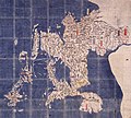 Keichō Kuniezu - Hizen Province (1837 copy of lost c.1605 original) (Takeo City Library and Historical Museum)
 -

-
-
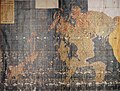
 Tenpō Kuniezu - Hizen Province, with Chikuzen in pink and Chikugo in yellow (1838) (National Archives of Japan)
_(Takeo_City_Library_and_Historical_Museum).jpg)
.jpg)
.jpg)
.jpg)
See also
[edit]Notes
[edit]- ^ NHK Broadcasting Culture Research Institute, ed. (24 May 2016). NHK日本語発音アクセント新辞典 (in Japanese). NHK Publishing.
- ^ Nussbaum, Louis-Frédéric. (2005). "Hizen" in Japan Encyclopedia, p. 338, p. 338, at Google Books.
- ^ US Department of State. (1906). A digest of international law as embodied in diplomatic discussions, treaties and other international agreements (John Bassett Moore, ed.), Vol. 5, p. 759.
References
[edit]- Nussbaum, Louis-Frédéric and Käthe Roth. (2005). Japan encyclopedia. Cambridge: Harvard University Press. ISBN 978-0-674-01753-5; OCLC 58053128
- Papinot, Edmond. (1910). Historical and Geographic Dictionary of Japan. Tokyo: Librarie Sansaisha. OCLC 77691250
Other websites
[edit]![]() Media related to Hizen Province at Wikimedia Commons
Media related to Hizen Province at Wikimedia Commons
- Murdoch's map of provinces, 1903
- National Archives of Japan: Hinozenshu sanbutsu zuko, scroll showing illustrated inventory of industries in Karatsu Domain, 1773-1784
| National | |
|---|---|
| Other | |
Hizen Province
View on GrokipediaGeography
Location and Terrain
Hizen Province was situated in the northwestern region of Kyushu island, encompassing territories that now form Saga and Nagasaki prefectures.[8][12] The province extended along the western coast of Kyushu, with its northern boundary adjoining Chikuzen Province, eastern limits shared with Chikugo Province, and southern edge meeting Higo Province.[13][14] This positioning placed Hizen at the forefront of maritime connections to the Asian mainland. The terrain of Hizen featured a diverse landscape, including coastal plains and ria inlets along the East China Sea and Ariake Sea coastlines, which provided sheltered bays and access points. Inland areas transitioned to undulating hills and low mountains, with the Sefuri Mountains dominating the northern sector, where peaks such as Mount Tenzan reached approximately 1,050 meters.[15] Major rivers, including the Matsuura River originating in the Sefuri range, flowed westward through the province, depositing sediments that formed fertile alluvial terraces.[16] This varied topography, combining accessible coastal zones with protective inland elevations, shaped the province's environmental context and supported early human settlement patterns along rivers and shores.[17]Natural Resources and Climate
Hizen Province featured abundant deposits of kaolin clay in the Arita region, discovered around 1616 by Korean potter Yi Sam-pyeong, enabling the establishment of high-fired porcelain production that relied on this heat-resistant mineral for durable, translucent ceramics.[8][7] This resource concentrated industrial activity in interior mountainous zones, where clay extraction complemented local fuel sources like wood for kilns, fostering proto-industrial specialization independent of coastal trade dependencies.[18] Coal seams were present in coastal and near-shore areas such as Karatsu, Takashima, and Hirado, with mining operations documented from the late Edo period onward, providing combustible material for smelting and early steam technologies that reduced reliance on charcoal and supported regional energy needs.[19] These deposits, though not the largest in Japan, contributed to localized extraction economies, with output varying by seam quality and labor availability, influencing settlement patterns toward extractive communities rather than purely agrarian ones.[20] The province's humid subtropical climate, marked by hot, wet summers and mild winters, delivered annual rainfall exceeding 1,800 mm in many areas, ideal for irrigated rice paddies that formed the agricultural backbone, yielding staple crops through monsoon-fed hydrology.[21] However, frequent typhoons—averaging 3–5 landfalls per season from the East China Sea—caused flooding and crop losses, necessitating terraced fields and elevated storage to mitigate erosion and preserve yields, thereby enforcing adaptive farming over expansive flatland monoculture.[22] Coastal exposure to the Sea of Japan and East China Sea yielded marine resources including sardines, yellowtail, and shellfish, harvested via near-shore netting and tidal methods, which supplemented terrestrial output and buffered against climatic variability without evidence of overexploitation in pre-modern records.[23] This bounty directed populations toward port-adjacent villages, where fisheries integrated with mineral transport, amplifying resource synergies under environmental constraints.[24]History
Ancient and Nara-Heian Periods
Hizen Province was formally organized under the ritsuryō legal and administrative codes promulgated in 701 CE, integrating it into the Saikaidō circuit of the Gokishichidō system that divided Japan into approximately 66 provinces for centralized governance and taxation.[25] This framework imposed uniform provincial structures across regions previously characterized by tribal or clan-based authority, with governors appointed from the capital to oversee local districts (gun) and collect rice-based levies.[25] The kokufu, or provincial capital, was established in what is now Karatsu, Saga Prefecture, functioning as the hub for administrative, judicial, and fiscal operations from the Nara period (710–794) through the early Heian period (794–1185).[26] Excavations at the site have uncovered rectangular building foundations, gates, and moated enclosures typical of ritsuryō layouts, along with artifacts such as inkstones and roof tiles indicating official bureaucratic activities.[26] Storage warehouses (kura) for rice tribute highlight the shift to systematic revenue collection, supporting imperial infrastructure and military needs.[25] As a frontier province in western Kyushu, Hizen operated under the supervisory authority of Dazaifu, the regional headquarters in Chikuzen Province responsible for continental interactions, including the reception of envoys from Silla and Tang China and defenses against pirate incursions from the Korean Peninsula during the 8th–9th centuries.[27] This arrangement facilitated Hizen's role in diplomatic missions and coastal vigilance, evidenced by historical records of local officials coordinating with Dazaifu forces.[27] Archaeological evidence from Yayoi-period sites in Hizen, such as pottery and settlement remains attesting to wet-rice cultivation introduced around 300 BCE, underscores the empirical basis for later ritsuryō taxation, evolving from communal farming to state-mandated yields measured in koku units.[28][25]Kamakura to Sengoku Periods
The Kamakura shogunate (1185–1333) introduced the shugo system, appointing military governors to provinces like Hizen to enforce warrior rule and decentralize power from the imperial court, fostering local clan autonomy amid feudal fragmentation. Neighboring powers, including the Ōtomo in Bungo Province and Shimazu in Satsuma, exerted indirect influence over Hizen's affairs through alliances and territorial pressures, as northern Kyushu's strategic position amplified regional rivalries. The Mongol invasions of 1274 and 1281 further strained Hizen's resources, requiring mobilization of local samurai for coastal defenses and shipbuilding, which exacerbated economic burdens and solidified warrior class dominance without achieving full conquest due to typhoons and Japanese resistance.[29] In the ensuing Muromachi period (1336–1573), weakened central authority under the Ashikaga shogunate enabled Hizen's provincial warriors to challenge traditional estates, setting the stage for Sengoku-era (1467–1603) anarchy characterized by clan wars and power vacuums. The Ryūzōji clan, initially retainers to the Shōni, rose prominently under Takanobu (1530–1584), dubbed the "Bear of Hizen" for his ruthless expansions; by the 1560s–1570s, he subdued much of Hizen and parts of neighboring Chikuzen and Higo through decisive battles, consolidating daimyo control via superior tactics and vassal networks.[30][31] Takanobu's defeat and death at the Battle of Okitanawate on May 4, 1584, against Shimazu forces fragmented Ryūzōji holdings, allowing Toyotomi Hideyoshi to subjugate the remnants during his 1587 Kyushu campaign, which imposed unified command and redistributed lands to loyalists, curtailing local autonomy. Concurrently, Portuguese contact in 1543—via shipwrecked traders on Tanegashima Island near Hizen—introduced matchlock firearms, rapidly adopted by Kyushu lords including Ryūzōji forces, shifting warfare from elite archery duels to volley fire and massed infantry, enhancing offensive capabilities in dense terrain. Jesuit missions from 1549 onward brought Christianity, initially as a trade adjunct, but its doctrinal emphasis on exclusivity clashed with Japan's syncretic traditions, yielding marginal conversions amid persistent conflict.[32]Edo Period Developments
, facilitating regulated foreign interactions without granting autonomy to a local daimyō.[8][33] The implementation of sakoku policies from 1633 to 1639 restricted foreign access, culminating in the establishment of Dejima as an artificial island in Nagasaki Harbor in 1641, where the Dutch East India Company (VOC) held a monopoly on European trade. This confinement limited Western influence to controlled exchanges, primarily enabling the transmission of empirical knowledge through Dutch texts and interpreters, which fostered rangaku (Dutch learning) in fields like medicine, astronomy, and mechanics among Japanese scholars accessing materials via Nagasaki.[34][5] Economic innovations thrived under these constraints, with porcelain production in Arita's kilns, initiated around 1616 using locally discovered kaolin, expanding significantly from the 1620s onward. By the mid-17th century, Arita ware was exported in large volumes aboard VOC ships from Nagasaki, contributing to Hizen's role as a hub for high-value craftsmanship that bolstered domain revenues without undermining shogunal authority. Complementing this, the Tōjin yashiki (Chinese quarter) in Nagasaki managed tribute-bearing Chinese junks, handling silk, sugar, and medicinal imports in exchange for silver and copper, thus sustaining intra-Asian trade circuits segregated from European activities.[7][35] The shogunate's emphasis on order through rigorous oversight and suppression of dissent preserved social hierarchies, countering potential disruptions from economic disparities or external ideas, and prioritizing long-term stability over redistributive ideals.[36]Abolition and Meiji Integration
The Hizen Province was formally abolished in July 1871 through the haihan chiken policy, which dismantled the feudal domain system and established prefectural administration under central imperial control.[37] This nationwide reform reduced approximately 261 domains to 302 initial prefectures, centralizing authority to enable unified modernization and military mobilization. Hizen's territories were divided primarily into Saga Prefecture, derived from the Saga domain ruled by the Nabeshima clan, and Nagasaki Prefecture, which absorbed the Nagasaki coastal region, Hirado domain, and other western Hizen districts.[13] Under daimyo Nabeshima Naomasa (r. 1828–1871), the Saga domain within Hizen had already implemented targeted reforms, including the introduction of Western-style cannon manufacturing, shipbuilding, and administrative streamlining to bolster defenses amid foreign pressures.[38][39] These domain-level innovations, driven by pragmatic adaptation rather than ideological overhaul, provided a practical foundation for national industrialization post-abolition, as Saga's technical expertise—such as early experimentation with steam engines and railways—integrated into broader imperial projects without requiring wholesale reinvention. The feudal structure's allowance for localized, risk-managed experimentation thus demonstrated causal efficiencies in fostering technological readiness, even as centralization curtailed such autonomy. Saga natives like Ōkuma Shigenobu, who rose through Nabeshima patronage to become finance minister in 1873, advanced key Meiji policies, including fiscal overhauls that standardized national currency issuance and reduced reliance on domain-specific monies.[40] Ōkuma's advocacy for constitutional limits on imperial power further linked Hizen's tradition of guarded openness—rooted in Nagasaki's trade role—to resilient governance structures. Yet the transition's abruptness revealed frictions: the elimination of samurai stipends and domain privileges fueled discontent, culminating in the 1874 Saga Rebellion led by ex-retainer Etō Shimpei, where roughly 3,000 insurgents briefly challenged central forces before suppression, underscoring the human costs of reallocating resources from feudal hierarchies to capitalist imperatives.[41]Administrative Structure
Historical Districts and Kokuga
Hizen Province was subdivided into multiple gun (districts) under the ritsuryō administrative system, with records indicating up to eleven such units by the medieval period. Key districts included Kii-gun (基肄郡), Yafu-gun (養父郡), Mine-gun (三根郡), Kamisaki-gun (神埼郡, also known as Kanzaki-gun), Saga-gun (佐賀郡), and Ogi-gun (小城郡), alongside coastal-focused Matsuura-gun (松浦郡) and Sonogi-gun (彼杵郡), which facilitated maritime oversight and defense.[42] These districts originated from the province's formation in 713 CE, when it was carved from northern Higo Province and parts of Chikuzen, reflecting the Taika Reforms' emphasis on centralized land and population registers for taxation.[43] The kokuga (provincial office) served as the central administrative hub, responsible for implementing imperial edicts, collecting land taxes in kind (typically rice and cloth), organizing corvée labor for public works and military service, and maintaining judicial records. Archaeological evidence from the Hizen Kokuchō ato site in Saga Prefecture reveals a compound with moats, gates, and administrative buildings dating to the late Nara (710–794 CE) and early Heian (794–1185 CE) periods, underscoring its role in sustaining bureaucratic continuity amid local power shifts.[44] This structure evolved minimally from the 8th-century establishment, overlaying earlier Yayoi and Kofun period settlements, and persisted until the Kamakura period's feudal overlays diminished central control without fully supplanting district-based jurisdictions.[45]| District (Gun) | Key Features and Location |
|---|---|
| Matsuura-gun | Coastal, centered on northern Hizen; vital for naval activities and trade routes to Korea and Tsushima.[42] |
| Sonogi-gun | Southern coastal district; supported fisheries and defense against piracy.[42] |
| Saga-gun | Inland, agricultural core; site of early administrative centers.[42] |
| Kanzaki-gun | Eastern boundary; linked to riverine transport and rice production.[42] |
Feudal Domains (Han)
The feudal domains within Hizen Province during the Edo period were dominated by Saga Domain, ruled by the tozama Nabeshima clan with an assessed yield of 357,000 koku, enabling it to maintain a large samurai retinue and invest in military innovations such as cannon casting and gunnery training as early as 1837.[48][49] This substantial kokudaka, equivalent to roughly ¥107 billion in modern terms, supported domain-wide economic policies that prioritized technical advancements, including armaments factories producing Western-style weapons, which bolstered Saga's influence amid inter-domain dynamics in western Japan.[48][50] Smaller domains included Hirado Domain under the Matsuura clan, focused on naval capabilities stemming from their historical role in maritime defense and trade facilitation with Europeans prior to sakoku restrictions, allowing the clan to sustain a modest but strategically vital presence.[51] Karatsu Domain, controlled by fudai clans such as the Ogasawara from 1817 onward, operated at around 60,000 koku, with its castle town serving as a hub for local governance and resource extraction.[52] Shimabara Domain was effectively abolished following the 1637-1638 rebellion, with its territories redistributed primarily to Saga Domain and shogunal oversight, preventing reestablishment as an independent han and illustrating the shogunate's punitive consolidation of power.[53] Nagasaki, as a key port, fell under direct shogunal tenryō control rather than a daimyō han, managed by bugyō officials to regulate foreign trade with Dutch and Chinese merchants, ensuring centralized oversight of Hizen's external economic links without delegating authority to local lords.[54] These arrangements fostered rivalries, such as Saga's oversight of adjacent territories post-Shimabara, while the variable koku assessments—Saga's outsized share versus smaller domains' allocations—reflected causal factors in feudal sustainability, where larger yields funded samurai stipends comprising up to 70-80% of domain expenditures, maintaining social order through rice-based hierarchies.[55]| Domain | Ruling Clan | Koku Assessment | Primary Castle Town |
|---|---|---|---|
| Saga | Nabeshima | 357,000 | Saga |
| Hirado | Matsuura | ~63,000 | Hirado |
| Karatsu | Ogasawara | ~60,000 | Karatsu |
| Nagasaki | Shogunal | N/A (tenryō) | Nagasaki |