

Community hub
Recent from talks
Contribute something
Nothing was collected or created yet.
Isla del Sol
View on Wikipedia
Isla del Sol (Spanish for "Island of the Sun") is an island in the southern part of Lake Titicaca. It is part of Bolivia, and specifically part of the La Paz Department. Geographically, the terrain is harsh; it is a rocky, hilly island with many eucalyptus trees. There are no motor vehicles or paved roads on the island. The main economic activity of the approximately 800 families on the island is farming, with fishing and tourism augmenting the subsistence economy. Of the several villages, Yumani and Challapampa are the largest.[1]
There are over 80 ruins on the island. Most of these date to the Inca period circa the 15th century AD. Archaeologists have discovered evidence that people lived on the island as far back as the third millennium BC. Many hills on the island contain agricultural terraces, which adapt steep and rocky terrain to agriculture. Among the ruins on the island are Titi Qala (Aymara titi Andean mountain cat; lead, lead-colored, qala stone,[2] "mountain cat stone" or "lead stone", also spelled Titikala), a labyrinth-like building called Chinkana, Q'asa Pata, and Pillkukayna. In the religion of the Incas, it was believed that the sun god was born here.
Etymology
[edit]
The Aymara name for the island is Titi'kaka. The original meaning of this word is not known. Some linguists and archaeologists believe the name to be a corruption of titi (Andean mountain cat; lead, lead-colored) and qala (rock). In the 1612 Aymara-Spanish dictionary of Ludovico Bertonio, the phrase Tahksi kala is listed as "piedra fundamental" or "foundation stone" possibly alluding to the origin story of the Inca that the Sun and Moon were born in the lake.[3]
History
[edit]
The chronicler Bernabé Cobo documented two versions of an Inca origin myth that took place on the northern part of this island.[4] The first Inca Manco Cápac is said to have emerged from a prominent crag in a large sandstone outcrop known as Titi Qala. Manco Cápac is the son of Inti the Andean deity identified as the sun. In one version of the myth, the ancient people of the province were without light in the sky for many days and grew frightened of the darkness. Finally, the people saw the Sun emerge from the crag and believed it was the Sun's dwelling place. In another version related by Cobo, others believed the crag was dedicated to the Sun because it hid under the crag during a great Flood. Isla del Sol was the first land that appeared after the flood waters began to recede and the Sun emerged from Titi Qala to illuminate the sky once again. A temple was built at this rock and later expanded by the 10th Inca Tupac Inca Yupanqui. He built a convent for mamaconas (chosen women) and a tambo (inn) for visiting pilgrims.
Archaeology
[edit]
Excavations at the archaeological site of Ch'uxu Qullu, located on a small peak above the Bay of Challa, led to the recovery of Archaic Preceramic remains that radiocarbon dated to about 2200 BC.[5] Eight obsidian flakes were recovered from this context, and Neutron Activation Analysis of three of the flakes revealed that all of them were from the Chivay obsidian source which is located in the Colca Canyon, Department of Arequipa. The presence of Chivay obsidian is clear evidence that inhabitants of the island were participating in a wider network of exchange.
Chivay obsidian has also been used at a nearby archaeological site, Jisk'a Iru Muqu, located on Peruvian territory. This indicates cultural continuity between these two sites in the same preceramic time frame.
Geological studies
[edit]According to one bathymetric model,[6] there is no path between the shore edge and the Island of the Sun that does not pass over areas where the lake bottom reaches a depth of 200 m (660 ft) or greater. Paleoclimate studies indicate that around 3100 BC the level of Lake Titicaca would have been as much as 85 m (279 ft) lower than modern conditions, but that it had reached near modern levels by about 2000 BC.[7][8][9] Thus, at 2200 BC lake levels were probably lower than at present but still high enough that the island was separated by water from the mainland. Data from Ch'uxuqullu therefore indicates that the lake shore cultures were using well-developed watercraft technology during the Archaic period.[5]
Occupation history
[edit]
The island was continually occupied from at least 2200 BC up to the present day. There is a significant Early Formative occupation (1800-1100 BC), Middle Formative (1100-500 BC) and Upper Formative (500 BC - AD 500).
The earliest recorded pottery on the island dates to between 1426 and 1316 B.C.[5]
Most significantly, there is a major Tiwanaku (Tiahuanaco) settlement on the island. The site of Chucaripupata was a major Tiwanaku ritual site located above the Titi Qala, that the Incas made famous.
All these sites are located on the western side of the island.

Chucaripupata is only a few hundred meters from Titi Qala, and immediately above them is a rock outcrop known as Murokata. It is therefore possible that Murokata was the "sacred rock" of the Tiwanaku culture.[10]
The archaeological evidence indicates that neither Murokata nor Titi Qala were used during the Late Intermediate Period (ca AD 1000–1450). With the conquest of the southern Titicaca region by the Inca, the Titi Qala zone was converted into one of the most important pilgrimage destinations in the Inca state on par with the famous oracle at Pachacamac on the coast just south of Lima.
Underwater archaeological investigations conducted off the Island of the Sun from 1989 to 1992 led to the discovery of both Inca and Tiahuanaco artifacts. These are now on display at a site museum in Challapampa.[11] Today the economy of the island is mainly driven by tourism revenues, but subsistence agriculture and fishing are widely practiced.
Climate
[edit]| Climate data for Isla de Sol (located in Yumani), elevation: 3,976 metres (13,045 ft), 1981–2010 normals, extremes 1978–present | |||||||||||||
|---|---|---|---|---|---|---|---|---|---|---|---|---|---|
| Month | Jan | Feb | Mar | Apr | May | Jun | Jul | Aug | Sep | Oct | Nov | Dec | Year |
| Record high °C (°F) | 21.0 (69.8) |
21.0 (69.8) |
20.0 (68.0) |
21.0 (69.8) |
20.0 (68.0) |
19.8 (67.6) |
19.2 (66.6) |
20.4 (68.7) |
20.9 (69.6) |
23.0 (73.4) |
24.6 (76.3) |
21.0 (69.8) |
24.6 (76.3) |
| Mean daily maximum °C (°F) | 14.4 (57.9) |
14.4 (57.9) |
14.6 (58.3) |
14.4 (57.9) |
14.3 (57.7) |
13.7 (56.7) |
13.4 (56.1) |
13.9 (57.0) |
14.5 (58.1) |
15.0 (59.0) |
15.2 (59.4) |
15.1 (59.2) |
14.3 (57.7) |
| Daily mean °C (°F) | 9.4 (48.9) |
9.5 (49.1) |
9.5 (49.1) |
9.4 (48.9) |
9.0 (48.2) |
8.2 (46.8) |
7.9 (46.2) |
8.4 (47.1) |
9.0 (48.2) |
9.6 (49.3) |
9.7 (49.5) |
9.8 (49.6) |
9.1 (48.4) |
| Mean daily minimum °C (°F) | 4.4 (39.9) |
4.5 (40.1) |
4.5 (40.1) |
4.4 (39.9) |
3.6 (38.5) |
2.7 (36.9) |
2.5 (36.5) |
3.0 (37.4) |
3.5 (38.3) |
4.1 (39.4) |
4.4 (39.9) |
4.5 (40.1) |
3.9 (39.0) |
| Record low °C (°F) | −4.0 (24.8) |
−2.0 (28.4) |
−2.3 (27.9) |
−3.0 (26.6) |
−4.0 (24.8) |
−3.0 (26.6) |
−4.5 (23.9) |
−6.0 (21.2) |
−2.0 (28.4) |
−2.0 (28.4) |
−2.4 (27.7) |
−2.0 (28.4) |
−6.0 (21.2) |
| Average precipitation mm (inches) | 164.1 (6.46) |
117.4 (4.62) |
97.1 (3.82) |
44.5 (1.75) |
11.5 (0.45) |
11.2 (0.44) |
5.5 (0.22) |
24.0 (0.94) |
28.4 (1.12) |
38.2 (1.50) |
51.7 (2.04) |
96.6 (3.80) |
641.2 (25.24) |
| Average precipitation days | 15.9 | 13.6 | 11.5 | 6.4 | 2.7 | 2.9 | 1.6 | 3.8 | 4.9 | 6.7 | 7.6 | 12.2 | 87.1 |
| Average snowy days | 0.0 | 0.0 | 0.0 | 0.0 | 0.0 | 0.0 | 0.04 | 0.08 | 0.0 | 0.0 | 0.0 | 0.0 | 0.15 |
| Mean monthly sunshine hours | 167.5 | 154.7 | 170.0 | 190.6 | 238.8 | 190.2 | 219.7 | 266.4 | 219.1 | 229.5 | 236.8 | 190.8 | 2,474.1 |
| Mean daily sunshine hours | 6.9 | 6.3 | 6.9 | 7.5 | 8.4 | 7.0 | 8.6 | 9.0 | 8.5 | 8.0 | 9.0 | 6.8 | 7.7 |
| Source: Servicio Nacional de Meteorología e Hidrología de Bolivia[12] | |||||||||||||
Gallery
[edit]-
 The ruins of Pillkukayna, at the southern end of the island.
 -
 Walking path down the centre of the island.
 -
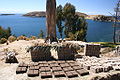 Adobe bricks drying in the sun.


Notes
[edit]- ^ p209 Lonely Planet South America on a Shoestring 2008
- ^ Radio San Gabriel, "Instituto Radiofonico de Promoción Aymara" (IRPA) 1993, Republicado por Instituto de las Lenguas y Literaturas Andinas-Amazónicas (ILLLA-A) 2011, Transcripción del Vocabulario de la Lengua Aymara, P. Ludovico Bertonio 1612 (Spanish-Aymara-Aymara-Spanish dictionary)
- ^ Stanish, Charles 2003 Ancient Titicaca. University of California Press
- ^ Cobo, Bernabé 1990[1653] History of the Inca Empire. University of Texas, Austin.
- ^ a b c Stanish, Charles; Burger, Richard L.; Cipolla, Lisa M.; Glascock, Michael D.; Quelima, Esteban (December 2002). "Evidence for Early Long-Distance Obsidian Exchange and Watercraft Use from the Southern Lake Titicaca Basin of Bolivia and Peru". Latin American Antiquity. 13 (4): 444–54. doi:10.2307/972225. JSTOR 972225.
- ^ Ybert, Jean-Pierre (2012). "Ancient lake environments as deduced from pollen analysis". In Dejoux, C. (ed.). Lake Titicaca: A Synthesis of Limnological Knowledge. pp. 49–62. ISBN 978-94-011-2406-5.
- ^ Cross, Scott L.; Baker, Paul A.; Seltzer, Geoffrey O.; Fritz, Sherilyn C.; Dunbar, Robert B. (2001). "Late Quaternary Climate and Hydrology of Tropical South America Inferred from an Isotopic and Chemical Model of Lake Titicaca, Bolivia and Peru". Quaternary Research. 56 (1): 1–9. Bibcode:2001QuRes..56....1C. doi:10.1006/qres.2001.2244.
- ^ Baker, Paul A.; Rigsby, Catherine A.; Seltzer, Geoffrey O.; Fritz, Sherilyn C.; Lowenstein, Tim K.; Bacher, Niklas P.; Veliz, Carlos (2001). "Tropical climate changes at millennial and orbital timescales on the Bolivian Altiplano". Nature. 409 (6821): 698–701. Bibcode:2001Natur.409..698B. doi:10.1038/35055524. PMID 11217855.
- ^ Baker, P. A.; Seltzer, Geoffrey O.; Fritz, Sherilyn C.; Dunbar, Robert B.; Grove, Matthew J.; Tapia, Pedro M.; Cross, Scott L.; Rowe, Harold D.; Broda, James P. (2001). "The History of South American Tropical Precipitation for the Past 25,000 Years". Science. 291 (5504): 640–3. Bibcode:2001Sci...291..640B. doi:10.1126/science.291.5504.640. PMID 11158674.
- ^ Bauer, Brian and Charles Stanish 2001 "Ritual and Pilgrimage in the Ancient Andes" University of Texas press, Austin[page needed]
- ^ Reinhard, Johan "Underwater Archaeological Research in Lake Titicaca, Bolivia" in Ancient America: Contributions to New World Archaeology, 1992. N. Saunders (ed.), Oxford: Oxbow Books, pp. 117-143
- ^ "Base de datos Sistema Meteorológico–SISMET" (in Spanish). Servicio Nacional de Meteorología e Hidrología de Bolivia. Archived from the original on 21 September 2019. Retrieved 21 September 2019.
External links
[edit]![]() Media related to Isla Del Sol, Bolivia at Wikimedia Commons
Media related to Isla Del Sol, Bolivia at Wikimedia Commons
Isla del Sol
View on GrokipediaGeography
Location and Extent
Isla del Sol is situated in the southern portion of Lake Titicaca, South America's largest freshwater lake by volume, within Bolivia's La Paz Department.[4][5] The island lies at coordinates approximately 16°01′S 69°10′W and reaches an elevation of 3,812 meters (12,507 ft) above sea level, matching the lake's surface level.[6][4] Measuring roughly 9 km (5.6 miles) in length and up to 4 km (2.5 miles) in width, Isla del Sol spans an area of about 14.3 square km (5.5 square miles), establishing it as the largest island in Lake Titicaca.[7] It is positioned approximately 3 km northwest of the Copacabana Peninsula on the Bolivian mainland.[8] The island is entirely within Bolivian territorial waters, distinguishing it from adjacent Peruvian islands such as Taquile.[4] Administratively, Isla del Sol is divided among three Aymara communities: Yumani in the south, Challa in the center, and Challapampa in the north.[9][10] This division reflects local indigenous organizational structures among the Aymara people who inhabit the island.[8]Topography and Geology
Isla del Sol exhibits a rugged topography dominated by steep, terraced hillsides that ascend from the lake's edge at approximately 3,810 meters (12,500 ft) to a highest point of about 4,100 meters (13,500 ft) at Pachamama peak. The island's landscape features narrow, winding paths traversing elevated ridges that offer sweeping panoramic views of Lake Titicaca, interspersed with small coves and rocky outcrops along the shoreline. Natural harbors, such as those at Yumani in the south and Challapampa in the north, provide sheltered docking points for boats, facilitating access to the island's remote communities. Despite the absence of permanent rivers, small springs emerge from the terrain, including the notable three-spouted Inca Fountain near Yumani, supporting limited local water needs.[11][3][12][13] Geologically, Isla del Sol forms part of a block fault uplift on the Copacabana Peninsula, composed primarily of Middle Devonian marine sedimentary rocks, including sandstones and shales measuring up to 3,000 meters thick. These ancient formations are linked to the broader Andean orogeny, where tectonic compression has folded and faulted the strata over multiple cycles, from Late Paleozoic to Pliocene times. The island's position within the Lake Titicaca basin reflects ongoing tectonic activity along Andean fault lines, with evidence of high-angle faults dividing the lake and contributing to its irregular depth profile, reaching up to 281 meters. Sedimentary layers in the region preserve records of ancient lake levels, including clays deposited over 100 meters above the current shoreline during late Pliocene to early Pleistocene highstands.[14][15] The interplay of geology and topography has shaped human adaptation on the island, where erosion from steep slopes and seismic influences has necessitated terraced agriculture on the hillsides to prevent soil loss and support cultivation. The rugged, rocky terrain, devoid of extensive vegetative cover in many areas due to the high altitude and exposure, underscores the island's vulnerability to erosional processes tied to the region's active tectonics.[3][14]Mythology and Cultural Significance
Inca Legends
In Inca cosmology, Isla del Sol in Lake Titicaca served as the primordial site of creation, where the creator god Viracocha emerged from the waters during a time of darkness and fashioned the sun god Inti and the moon goddess Mama Killa from rock or clay.[16] According to chronicler Bernabé Cobo, Viracocha ordered these celestial bodies to ascend from the island, establishing the cosmic order.[16] Legends also describe the moon initially shining brighter than the sun, which dimmed it out of jealousy by casting ashes upon her.[17] This positions the island as the birthplace of the luminaries, integral to the Inca worldview of divine emergence from the lake's depths.[17] A parallel origin tale recounts how Inti dispatched his children, Manco Cápac and Mama Ocllo, from the island's sacred rock—known as Titi Qala or the Rock of the Puma—to civilize the world and establish the Inca dynasty. Emerging as the first Inca rulers, they carried a golden staff as a divine emblem, using it to identify the fertile valley where they founded Cusco, symbolizing the transfer of solar authority from Titicaca to the imperial heartland.[3] This myth underscores the island's role as the "navel of the world," the geographic and spiritual center of Tawantinsuyu, where earthly and celestial realms converged.[16] The legends also evoke associations with water deities and lake spirits, reflecting rituals of offerings to appease these entities for fertility and protection. Variations appear in Aymara and Quechua oral traditions predating full Inca incorporation, with Aymara accounts emphasizing Tiwanaku influences near the lake, where Viracocha's creations intertwined local pre-Inca motifs of giants and petrified ancestors, while Quechua versions aligned the myths more closely with solar imperial ideology.[16]Religious and Symbolic Role
Isla del Sol held a central place in Inca religion as a major pilgrimage destination, drawing worshippers from across the empire for offerings, divinations, and ceremonies aligned with the solar calendar, including processions from mainland shrines like Copacabana to sacred wak'as on the island.[18] These practices reinforced the island's role in Inca cosmology, where it was viewed as the birthplace of the sun and a key node in imperial religious networks.[19] Pre-Inca Andean beliefs imbued the region around Lake Titicaca with profound spiritual meaning, portraying the lake's waters as a liminal space connecting the three Andean worlds—Hanan Pacha (upper world), Kay Pacha (this world), and Ukhu Pacha (underworld)—and venerating Pachamama, the earth mother, through offerings for harmony between humans and nature.[20] This cosmological framework emphasized rituals of reciprocity that persisted into colonial times. Modern syncretic practices blend these indigenous elements with Catholicism, as seen in Aymara communities maintaining earth-centered devotions alongside Christian saints.[20] Symbolically, Isla del Sol functioned as an axis mundi in Andean cosmology, bridging sky, earth, and water to symbolize cosmic order and serving as a foundational element in Inca imperial ideology that legitimated rule through claims of divine solar origins.[21] The island's shrines and rock formations, such as the Sacred Rock at Titikala, embodied this connection, representing the emergence of creation from the lake's depths and reinforcing the empire's narrative of sacred kingship tied to Inti.[21] In contemporary times, the island retains reverence through annual festivals like the Fiesta de la Virgen de Copacabana, where pilgrims from Aymara communities visit Lake Titicaca shores and extend processions to Isla del Sol for blended rituals of devotion.[22] Aymara shamans, known as yatiris, continue performing traditional ceremonies at key island sites, including sacrificial burnings and offerings to Pachamama for blessings and balance, preserving pre-Columbian spiritual continuity amid tourism.[23]History
Pre-Columbian Period
Human presence on Isla del Sol dates back to approximately 2000 BCE, with evidence of preceramic settlements indicating early adaptation to the island's isolated environment through watercraft use and resource exploitation.[24] These early inhabitants were linked to the broader Chiripa culture (ca. 1500–100 BCE), which featured ceremonial centers and the development of agriculture suited to the high-altitude lake basin, including the cultivation of crops like quinoa.[25] Archaeological sites such as Ch'uxuqullu and Titinhuayani reveal continuous occupation during the Formative period, with artifacts demonstrating connections to mainland communities through trade in nonlocal materials like obsidian sourced from distant valleys over 275 km away.[24] During the Tiwanaku period (ca. 300–1000 CE), Isla del Sol served as a key outpost for the Tiwanaku civilization, hosting over a dozen sites that underscore its role in regional networks.[19] The island functioned as a trade hub, facilitating the exchange of obsidian, metals, and agricultural products such as quinoa, with evidence of long-distance imports like Spondylus shells from Ecuador, transported over 2,000 km.[19] Ceremonial complexes, including the puma-shaped Chucaripupata and the port at Punku, represent precursors to Tiwanaku's monumental architecture, reflecting the island's integration into the polity's ritual and economic systems.[19] Underwater excavations at nearby Khoa Reef have uncovered Tiwanaku-era offerings, highlighting the site's spiritual significance during the 8th–10th centuries CE.[19] Following the Tiwanaku collapse around 1000 CE, the island transitioned to local Aymara chiefdoms during the Late Intermediate period (ca. 1000–1400 CE), characterized by fortified villages that suggest defensive adaptations amid regional conflicts.[26] These communities maintained agricultural innovations, including raised-field systems known as sukakollos, which involved elevated planting platforms with surrounding canals to manage high-altitude wetlands, enhance drainage, and mitigate frost—techniques originating in the Formative period but persisting post-Tiwanaku.[27] Such practices, combined with lake fishing and terrace farming, supported populations of up to several thousand inhabitants during peak periods, fostering self-sufficient chiefdoms in the southern Titicaca basin.[26]Inca and Colonial Eras
The Inca Empire expanded southward into the Collasuyu region, encompassing Lake Titicaca and Isla del Sol, during the reign of Pachacuti Inca Yupanqui from approximately 1438 to 1471 CE, marking the conquest and integration of local Aymara populations into the imperial structure. This incorporation transformed the island into a key religious and administrative center, with the construction of extensive agricultural terraces for high-altitude farming and a network of roads linking it to the broader Qhapaq Ñan system, facilitating pilgrimage and resource transport across the empire.[28] Archaeological surveys have identified over 80 Inca-period structures on the island, including temples and ceremonial complexes such as the Pilko Kaina palace and the Chincana labyrinth, dating primarily to the 15th century and underscoring its role as a hub for imperial rituals and governance.[3] Under later rulers like Huayna Capac (r. 1493–1527 CE), further developments reinforced the island's sanctity, with expansions to nearby sites like the Ila'ta on Isla de la Luna attributed to his era, reflecting ongoing investment in the Titicaca basin as a symbolic core of Inca cosmology.[29] The island served as a pilgrimage destination, drawing devotees from across the empire and supporting a dense network of settlements tied to its sacred landscape. The Spanish arrival in 1532 initiated the colonial era, during which sacred Inca sites on Isla del Sol and surrounding areas were desecrated as conquistadors and later officials systematically looted temples and huacas in search of gold and silver, disrupting indigenous religious practices. The region fell under the Viceroyalty of Peru, with local Aymara communities subjected to the encomienda system and later reductions, including Jesuit missions established near Lake Titicaca, such as in Juli, to convert and control indigenous populations from the mid-16th century onward.[30] These missions aimed to centralize Aymara labor and faith, leading to the suppression of pre-colonial rituals while imposing Catholic doctrines. Indigenous resistance persisted, culminating in the widespread Aymara and Quechua revolts of 1780–1783, including Túpac Katari's uprising in Upper Peru, which encircled La Paz and impacted the Lake Titicaca basin through allied actions against colonial authorities, though ultimately suppressed with severe reprisals. Following Bolivian independence in 1825, Isla del Sol came under the new republic's control as part of La Paz Department, with Aymara communities retaining communal ayllu lands despite broader national land reforms that favored elites. Ritual use of the island's sacred sites declined under secular republican policies and ongoing Christian influence, yet traditional practices endured in modified forms among locals.Archaeology
Major Sites
Isla del Sol is home to over 80 registered archaeological ruins, primarily dating to the Inca period in the 15th century, though some evidence points to earlier pre-Inca occupations.[31][3] These sites, scattered across the island's terraced landscape, include temples, labyrinths, and ceremonial structures that reflect the island's role as a sacred center in Inca cosmology. Many feature alignments with celestial events, underscoring their ritual importance, though detailed astronomical studies remain limited.[32][8] The Chincana complex, located at the northern tip of the island near Challapampa, is one of the most prominent Inca sites, characterized by a labyrinthine network of stone chambers and passages spanning approximately 200 meters. Known as the "labyrinth" in Quechua, it includes the Palacio del Inca, a maze-like enclosure with a central well, rock carvings depicting the Face of Viracocha, and nearby refuges dedicated to the sun and moon. The complex also features a Sacrificial Table, a flat stone altar used for rituals, and the Footprints of the Sun, natural rock impressions interpreted in Inca lore as marks left during divine emergence. These elements suggest the site served ceremonial functions, possibly linked to pilgrimage and initiation practices during the Inca era.[31][32][8] In the southern part of the island, the Pilko Kaina ruins (also spelled Pillkukayna) form a well-preserved Inca sun temple complex, situated along the shoreline about 2 kilometers south of Yumani. This two-story structure, camouflaged against rocky cliffs, boasts finely cut stone terraces, altars, and a distinctive triple-jamb doorway typical of Inca architecture, dedicated to the sun god Inti. The site's elevated position offers panoramic views across Lake Titicaca, enhancing its symbolic connection to solar worship and lake rituals. Archaeological features include ritual platforms and drainage channels, indicating use for offerings and ceremonies.[33][34] The Titi Qala, or Sacred Rock, is a prominent natural sandstone outcrop near the northern shore, revered as the emergence point of the Inca founder Manco Cápac and his sister-wife Mama Ocllo in mythological accounts. The rock bears large footprints etched into its surface, symbolizing the divine birth from Lake Titicaca sent by the sun god Inti to civilize the Andes. Inca enhancements, such as surrounding terraces and pathways, integrated the formation into a pilgrimage sanctuary, blending natural geology with constructed sacred space.[35][36] Other notable sites include the Yumani Steps, an Inca-engineered staircase of 206 stone steps ascending from the southern dock to a sacred spring in Yumani village, facilitating access to higher ritual areas and symbolizing ascent in Andean cosmology. These steps, hewn directly from bedrock, remain a key pathway for modern visitors exploring the island's southern ruins.[37]Research Findings
Archaeological research on Isla del Sol began with early explorations in the late 19th and early 20th centuries, when scholars like Adolph Bandelier conducted the first systematic surveys of the island's ruins in 1895, documenting Inca and pre-Inca structures such as terraces and temples.[38] Arthur Posnansky, a pioneering Bolivian archaeologist of Austrian origin, expanded on this work through surveys and publications in 1910–1912, producing an illustrated guide to the Islands of the Sun and Moon that linked Isla del Sol's sites to the Tiwanaku civilization, positing cultural continuities across the Lake Titicaca basin.[39] These efforts established the island as a key node in Andean prehistory, influencing subsequent interpretations of Tiwanaku's regional influence. Twentieth-century excavations built on these foundations, with major digs in the 1990s under the Proyecto Tiksi Kjarka revealing ceramics and structures from the Tiwanaku IV (ca. AD 200–500) and V (ca. AD 500–1000) phases at sites like Chucaripupata, including keros and vasijas bearing Tiwanaku motifs such as the front-face deity.[38] Radiocarbon dating of charcoal and organic remains from these layers confirmed occupations spanning the Tiwanaku period through the Inca era (ca. AD 1400–1532), with dates like 450 ± 50 BP at the Sacred Rock aligning with late pre-Columbian activity.[38] Slab cist burials and stone canals for offerings further indicated ritual functions, highlighting the island's role in Tiwanaku societal practices. Post-2000 projects have employed advanced techniques, including UNESCO-supported underwater surveys since 2012 by international teams from the Free University of Brussels and regional collaborators, which used sonar and diving to map submerged features near Isla del Sol without specific LiDAR applications on the island itself.[40] Carbon dating from these efforts, alongside lakeshore analyses, has reinforced evidence of continuous habitation from the Chiripa culture (ca. 1000–100 BC) on the mainland to Tiwanaku and Inca phases on the island, with dates from organic sediments indicating stable human presence amid fluctuating lake levels.[41] Key discoveries in the 2010s include gold fragments recovered in 2013 from Tiwanaku-era contexts near Isla del Sol, totaling 31 pieces suggestive of elite ritual use, though not directly from Chincana.[42] Underwater excavations at the Khoa Reef adjacent to the island uncovered intact Tiwanaku offerings, including gold-sheeted cylinders and shell figurines dated to AD 500–1000, pointing to pre-Inca solar-aligned rituals in the basin, such as horizon observations evidenced by aligned structures at related sites.[19] Scholarly debates center on the island's intermediary role in Tiwanaku-Inca cultural transmission, with artifacts like Tiwanaku-style ceramics at Inca-overlaid sites suggesting ideological continuity in elite legitimization and ritual practices across these eras.[43] Ongoing challenges include widespread looting, which has damaged archaeological sites in Bolivia, including terraces and burials on Isla del Sol, driven by black-market demand for ceramics and metals.[44] Climate-induced erosion exacerbates this, with rising lake levels and soil loss from wetter periods post-4.5 ka cal BP threatening raised fields and coastal ruins, as documented in sediment cores showing accelerated degradation.[45] Collaborative Bolivian-Peruvian research, facilitated by UNESCO since 2018, focuses on lakebed connections through joint underwater surveys, integrating data from both nations' shores to preserve shared heritage amid these threats. As of 2025, these efforts continue through regional workshops and monitoring to address looting and environmental risks.[46][40]Climate and Environment
Climate Patterns
Isla del Sol experiences a cool temperate highland climate, classified under the Köppen system as Cwb, characterized by mild summers and cold winters influenced by its location at approximately 3,810 meters (12,500 feet) above sea level in the Altiplano region. Average annual temperatures range from 5°C to 10°C (41°F to 50°F), with daytime highs reaching up to 15°C (59°F) during the summer months of December to March and nighttime lows dropping to -5°C (23°F) in the winter months of June to August.[47][48] Precipitation patterns exhibit a marked seasonal divide, with a dry season from May to October featuring minimal monthly rainfall of less than 10 mm and clear skies, contrasted by a wet season from November to April that brings up to 100 mm of rain per month, primarily in the form of afternoon showers and thunderstorms. The annual average precipitation totals 600–800 mm, concentrated in the wetter months and modulated by the surrounding Andean topography.[47][1][49] The island is subject to strong winds typical of the Altiplano, with speeds reaching up to 50 km/h, particularly during the dry season, driven by regional pressure gradients and the high-elevation plateau dynamics. Solar radiation is intense due to the 3,810-meter elevation, resulting in an extreme UV index often exceeding 11, necessitating precautions against ultraviolet exposure year-round.[50][51][52] Microclimatic variations exist across the island, with the southern slopes experiencing slightly warmer conditions owing to the moderating influence of Lake Titicaca's waters, which absorb and release heat more gradually than the surrounding air. Historical weather records from the nearby Copacabana meteorological station indicate relative stability in these patterns over past decades, but recent trends show increasing temperatures and variable precipitation due to climate change, contributing to declining lake levels, such as an 84 cm drop during the 2022-2023 drought.[53][54][55]Ecology and Biodiversity
Isla del Sol, situated in the Bolivian portion of Lake Titicaca, hosts a range of terrestrial and aquatic ecosystems shaped by its high-altitude Andean environment. Along the island's shores, totora reed beds (Schoenoplectus tatora) form dense emergent vegetation in shallow waters, providing critical habitat for aquatic species and stabilizing the lake margins against erosion.[56][57] Inland, the landscape transitions to highland puna grasslands, characterized by bunchgrasses that support grazing by domesticated camelids like llamas and alpacas, though these areas face pressures from human activity.[58] The island's flora reflects adaptations to the saline, high-altitude conditions of Lake Titicaca, with totora reeds dominating the littoral zones and serving as a foundational species for local ecosystems. Native Andean crops such as quinoa and potatoes are cultivated on terraced slopes, contributing to the agroecological diversity, while the lake's emergent vegetation includes submergent and floating plants that support algal communities.[58][57] Introduced species, including non-native trout in the lake fringes, have altered aquatic plant dynamics by competing with endemic forms.[56] Faunal diversity on and around Isla del Sol includes several endemic and characteristic Andean species. Mammals such as the Andean fox (Lycalopex culpaeus) inhabit the grassy uplands and shores, with domesticated camelids grazing on native vegetation. Birdlife is particularly rich, with over 100 species recorded in the Lake Titicaca basin, including the endangered Titicaca grebe (Rollandia microptera), which nests in reed beds, and other waterbirds like Andean gulls. Aquatic fauna features the critically endangered Titicaca giant frog (Telmatobius culeus), adapted to low-oxygen waters, alongside native fish such as Orestias species, though introduced trout pose ongoing threats through predation and habitat competition. Overgrazing by domesticated camelids and pollution from surrounding activities further endanger these populations. Recent climate change impacts, including droughts and rising temperatures as of 2025, exacerbate threats through algal blooms and habitat degradation.[58][59][56][60] Conservation efforts for Isla del Sol's biodiversity are integrated into broader Lake Titicaca initiatives, as the lake was designated a Ramsar wetland of international importance in 1997 to protect its unique ecosystems. The binational Autonomous Authority of the Lake Titicaca (ALT) coordinates restoration of native wetlands, control of invasive species like trout, and monitoring of endemic fauna, including the Titicaca grebe and giant frog. Local surveys have documented key biodiversity hotspots, emphasizing the need to address pollution, habitat degradation, and climate variability to preserve the island's ecological integrity.[4][56][61]Modern Communities and Tourism
Local Communities
Isla del Sol is home to approximately 3,000 inhabitants, predominantly Aymara people who form over 90% of the population and are bilingual in Aymara and Spanish.[62][63] The island features several small Aymara communities organized under traditional ayllu systems, with three main settlements—Yumani in the south, Challapampa in the north, and Challa in the center—each maintaining distinct governance structures rooted in communal assemblies and rotational leadership known as thakhi.[63] These communities are divided along a north-south axis, reflecting historical tensions over resources and tourism management, where northern and southern groups operate semi-autonomously. Note that access to the northern part of the island, including Challapampa and certain ruins, has been intermittently restricted due to community disputes as of 2025; check current status before visiting.[64] Daily life revolves around subsistence agriculture and herding, with residents cultivating potatoes, broad beans (habas), and quinoa on terraced fields, while raising llamas and sheep for wool and meat.[63] Traditional weaving remains a vital practice, particularly among women, who produce colorful textiles using natural dyes for clothing and crafts that preserve Aymara motifs and techniques passed down through generations.[63] Land is managed collectively under the ayllu system, a pre-colonial structure that emphasizes communal ownership and reciprocal labor, ensuring equitable access to resources amid the island's rugged terrain.[63] Socioeconomic conditions remain challenging, with significant poverty and limited access to basic services such as electricity, potable water, and waste management, though improvements have occurred since the early 2000s.[63] Education occurs in small community schools emphasizing bilingual instruction, while health concerns stem from the island's high altitude of about 3,810 meters, leading to respiratory issues, and isolation that limits medical access.[63] Cultural continuity is strong, with Aymara festivals such as ch'alla rituals honoring Pachamama (Mother Earth) and oral histories recounting ancestral ties to the island's sacred landscape.[63] Gender roles are integral, as women lead in weaving, household rituals, and agriculture, while men handle herding and community governance, fostering a resilient social fabric amid modern pressures.[63]Tourism and Access
Access to Isla del Sol is primarily by ferry from the nearby town of Copacabana on the Bolivian shore of Lake Titicaca, with daily services departing twice, typically at 8:30 a.m. and 1:30 p.m., and taking 45 to 90 minutes depending on the landing point in the north (Challapampa) or south (Yumani). Round-trip tickets cost approximately $5 to $10 USD, purchasable from local agencies or the dock, and there are no bridges, roads, or airports connecting the island, preserving its remote character.[8] Visitors can also cross the island on foot via the north-south trail, a 10-12 km ridge route that takes 4-5 hours and passes through community checkpoints where small fees (around 10-20 Bs) are collected to support local initiatives.[8] Popular activities center on the island's natural and cultural highlights, including hiking the main ridge trail—often called the Cross of the Island route for its central path—which offers panoramic views and brief glimpses of key Inca sites like Chincana ruins.[3] Organized ruin tours explore archaeological spots in the north and south, while boat excursions depart from Yumani for short trips around the lake or to nearby Isla de la Luna, emphasizing the sacred landscape. Eco-lodging options include community-run homestays that provide authentic stays with meals, promoting direct support for residents. Infrastructure remains basic and eco-friendly, with over 20 hostels and guesthouses offering simple rooms without luxury amenities, alongside a handful of restaurants specializing in fresh lake trout (trucha del lago) and Andean staples like quinoa soups. Local guides, often community members, lead tours for about 50-100 Bs per group, enhancing cultural immersion. The peak tourist season runs from June to August, drawing tens of thousands of visitors annually during the dry months, when clear skies ideal for hiking coincide with higher ferry traffic. Tourism serves as a primary economic driver for Isla del Sol's communities, generating a substantial portion of local income and funding essential services like schools and trail maintenance through visitor fees and homestay revenues.[65] However, rapid growth has raised sustainability concerns, including trail erosion from foot traffic and risks of cultural commodification amid north-south community tensions over tourism shares. Ethical travel practices, such as paying community entrance fees (20-50 Bs) and choosing locally operated accommodations, help mitigate these impacts and ensure benefits reach residents.[66]References
- https://en.wikivoyage.org/wiki/Isla_del_Sol