Recent from talks
Kuwae
Knowledge base stats:
Talk channels stats:
Members stats:
Kuwae
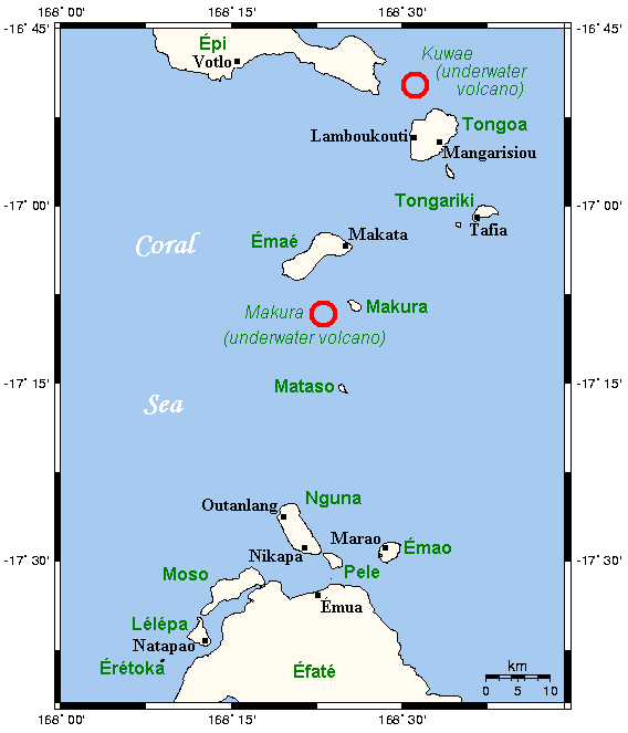
Kuwae was a landmass that existed in the vicinity of Tongoa and was destroyed by volcanic eruption in fifteenth century, probably through caldera subsidence. The exact location of the caldera is debated. A submarine caldera, now known as Kuwae caldera and which is located between the Epi and Tongoa islands, is a candidate. Kuwae caldera cuts through the flank of the Tavani Ruru volcano on Epi and the northwestern end of Tongoa. Another potential candidate is a proposed caldera between Tongoa and Tongariki.
The submarine volcano Karua, one of the most active volcanoes of Vanuatu, is near the northern rim of Kuwae caldera.
In Tongoan folklore, Kuwae is a lost land in the vicinity of Tongoa and was destroyed by a massive volcanic eruption, probably associated with caldera subsidence. In the legend of Ti Tongoa Liseiriki, the young man in Tongoa escaped the eruption along the coast of Kuwae to Tongariki which became a remnant of submerged Kuwae. This implies that Tongoa and Tongariki were connected by Kuwae landmass before the eruption. A submerged caldera is proposed in southeast of Tongoa and part of its western rim is above sea-level to form islands of Ewose, Buninga, and Tongariki. These islands are also described to be fragments of old Kuwae landmass in the folklore, consistent with presence of caldera in this location. But a bathymetric survey of this area could not confirm the presence of a caldera.
In 1994, bathymetry north of Tongoa revealed a large, 6×12-kilometer caldera between Tongoa and Epi, and it was named Kuwae caldera. However, whether or not the Kuwae caldera was responsible for the disappearance of Kuwae landmass and fifteenth century eruption in the folklore is debated, because oral traditions clearly describe it being south of Tongoa.
From which of these two calderas did the fifteenth century eruption derive has not been definitely identified.
Little is known about the pre-fifteenth century eruptive history of Kuwae volcano. Thick basalt and andesite lava flows and scoria agglomerates were produced from early effusive and strombolian eruptions over a long period of time. The oldest outcrop on Tongoa island is basalt dated to 73,000 years ago.
The major ignimbrite eruption was preceded by a period of low-intensity phreatomagmatic eruptions lasting months to years. These pre-climactic eruptions are similar to or less explosive than Surtseyan-style. Then the hydromagmatic phase was followed by major pyroclastic flows with gradually increasing eruptive temperature. Much of Tongoa and Epi islands are thickly blanketed with these pyroclastic flow deposits. The extent of pumice fall from this stage reached Tongariki island, and possibly southern end of Efaté Island. Pyroclastic flow with thickness >1 m is reported some 50 km from the eruptive centre. However, no plinian deposit is observed during any phase of the eruption.
Direct estimation of erupted magma volume based on field mapping of the deposits is impossible because the majority of the Kuwae ignimbrite was deposited in the sea. Further oceanographic surveys are needed to study the distribution of submarine ignimbrites and tephra fall deposits. If assuming the entire Kuwae caldera was formed during this eruption, then caldera dimension (total caldera subsidence may have been as great as 0.8–1.1 km) shows that about 30–60 km3 (DRE) was erupted, making this eruption of one of the largest in the last 10,000 years.
Hub AI
Kuwae AI simulator
(@Kuwae_simulator)
Kuwae
Kuwae was a landmass that existed in the vicinity of Tongoa and was destroyed by volcanic eruption in fifteenth century, probably through caldera subsidence. The exact location of the caldera is debated. A submarine caldera, now known as Kuwae caldera and which is located between the Epi and Tongoa islands, is a candidate. Kuwae caldera cuts through the flank of the Tavani Ruru volcano on Epi and the northwestern end of Tongoa. Another potential candidate is a proposed caldera between Tongoa and Tongariki.
The submarine volcano Karua, one of the most active volcanoes of Vanuatu, is near the northern rim of Kuwae caldera.
In Tongoan folklore, Kuwae is a lost land in the vicinity of Tongoa and was destroyed by a massive volcanic eruption, probably associated with caldera subsidence. In the legend of Ti Tongoa Liseiriki, the young man in Tongoa escaped the eruption along the coast of Kuwae to Tongariki which became a remnant of submerged Kuwae. This implies that Tongoa and Tongariki were connected by Kuwae landmass before the eruption. A submerged caldera is proposed in southeast of Tongoa and part of its western rim is above sea-level to form islands of Ewose, Buninga, and Tongariki. These islands are also described to be fragments of old Kuwae landmass in the folklore, consistent with presence of caldera in this location. But a bathymetric survey of this area could not confirm the presence of a caldera.
In 1994, bathymetry north of Tongoa revealed a large, 6×12-kilometer caldera between Tongoa and Epi, and it was named Kuwae caldera. However, whether or not the Kuwae caldera was responsible for the disappearance of Kuwae landmass and fifteenth century eruption in the folklore is debated, because oral traditions clearly describe it being south of Tongoa.
From which of these two calderas did the fifteenth century eruption derive has not been definitely identified.
Little is known about the pre-fifteenth century eruptive history of Kuwae volcano. Thick basalt and andesite lava flows and scoria agglomerates were produced from early effusive and strombolian eruptions over a long period of time. The oldest outcrop on Tongoa island is basalt dated to 73,000 years ago.
The major ignimbrite eruption was preceded by a period of low-intensity phreatomagmatic eruptions lasting months to years. These pre-climactic eruptions are similar to or less explosive than Surtseyan-style. Then the hydromagmatic phase was followed by major pyroclastic flows with gradually increasing eruptive temperature. Much of Tongoa and Epi islands are thickly blanketed with these pyroclastic flow deposits. The extent of pumice fall from this stage reached Tongariki island, and possibly southern end of Efaté Island. Pyroclastic flow with thickness >1 m is reported some 50 km from the eruptive centre. However, no plinian deposit is observed during any phase of the eruption.
Direct estimation of erupted magma volume based on field mapping of the deposits is impossible because the majority of the Kuwae ignimbrite was deposited in the sea. Further oceanographic surveys are needed to study the distribution of submarine ignimbrites and tephra fall deposits. If assuming the entire Kuwae caldera was formed during this eruption, then caldera dimension (total caldera subsidence may have been as great as 0.8–1.1 km) shows that about 30–60 km3 (DRE) was erupted, making this eruption of one of the largest in the last 10,000 years.
Recent media