

Community hub
Recent from talks
Contribute something
Nothing was collected or created yet.
New York State Route 22
View on Wikipedia
 New York State Route 22 | ||||
|---|---|---|---|---|
 NY 22 highlighted in red | ||||
| Route information | ||||
| Maintained by NYSDOT, NYCDOT, Clinton County, Westchester County, and the cities of Mount Vernon and Plattsburgh | ||||
| Length | 337.26 mi[1] (542.77 km) | |||
| Existed | 1924[2]–present | |||
| Tourist routes | ||||
| Major junctions | ||||
| South end | ||||
| ||||
| North end | ||||
| Location | ||||
| Country | United States | |||
| State | New York | |||
| Counties | Bronx, Westchester, Putnam, Dutchess, Columbia, Rensselaer, Washington, Essex, Clinton | |||
| Highway system | ||||
| ||||
New York State Route 22 (NY 22) is a north–south state highway that parallels the eastern border of the U.S. state of New York, from the outskirts of New York City to the hamlet of Mooers in Clinton County near the Canadian border. At 337 miles (542 km), it is the state's longest north–south route and the third longest state route overall, after NY 5 and NY 17.[a] Many of the state's major east–west roads intersect with, and often join, NY 22 just before crossing into the neighboring New England states, where U.S. Route 7 (US 7), which originally partially followed NY 22's alignment, similarly parallels the New York state line.
Almost all of NY 22 is a two-lane rural road through small villages and hamlets. The exceptions are its southern end in the heavily populated Bronx and lower Westchester County, and a section that runs through the city of Plattsburgh near the northern end. The rural landscape that the road passes through varies from horse country and views of the reservoirs of the New York City watershed in the northern suburbs of the city, to dairy farms further upstate in the Taconic and Berkshire mountains, to the undeveloped, heavily forested Adirondack Park along the shores of Lake Champlain. An 86-mile (138 km) section from Fort Ann to Keeseville is part of the All-American Road known as the Lakes to Locks Passage.
The oldest portions of today's NY 22, in Westchester County and along the Lake Champlain shoreline, were Native American trails. Dutch, and after them English, settlers continued to use the road to get their farm products to market, with the southernmost portion eventually becoming the White Plains Post Road in the 18th and 19th centuries. In the early 20th century, as automobile use became widespread, the state paved the more heavily used sections and built new roads to create the current highway, first designated as NY 22 in 1930. In its early years the highway began in Manhattan; until 2008 its northern end was the Canadian border.
Route description
[edit]NY 22 starts as an urban surface road, passing through the most populous communities along its route within its first 15 miles (24 km). After running northerly from its origin in the Bronx it veers slightly to the northeast in the vicinity of a traffic circle near Kensico Dam before heading northward for good as a mostly two-lane rural route all the way to the state's North Country.[5]
The majority of NY 22's 337-mile (542 km) routing is maintained by the New York State Department of Transportation (NYSDOT); however, several sections are maintained by other jurisdictions. The southernmost of these is in the Bronx, where the entirety of the highway within the borough is maintained by the New York City Department of Transportation (NYCDOT).[6] In Westchester County, NY 22 is mostly locally maintained within the city of Mount Vernon and is county-maintained within the city of White Plains.[7] In Clinton County, the route is locally maintained within the city of Plattsburgh.[8][b]
During its course, NY 22 intersects or runs concurrently with 46 other designated routes: one state parkway, five Interstate Highways, and seven U.S. Highways not counting its own termini. Of the surface road intersections, 18 terminate at NY 22 and 15 are concurrencies shared with the crossing routes, accounting for 72.6 miles (116.8 km), or 21.5% of the highway's total length.[10]
The Bronx to Kensico Dam
[edit]
NY 22 starts as Provost Avenue at U.S. Route 1 (US 1) in the Eastchester section of the Bronx, intersecting with East 233rd Street about 0.2 miles (320 m) to the north.[11] It soon crosses the Westchester county line into Mount Vernon and becomes South Third Avenue, beginning a 30-mile (48 km) section in that county.[5] Shortly after the county line, NY 22 makes a sharp turn to the east at the South Columbus Avenue intersection, soon passing St. Paul's Church National Historic Site on its north, then curving back to that direction. It parallels the nearby Hutchinson River Parkway as it passes through the suburbs of Bronxville and Tuckahoe. At Wilson Woods Lake, it crosses under a railroad bridge on the Metro-North New Haven Line and becomes North Columbus Avenue, then has its first interchange with a freeway at the Cross County Parkway.[7]
Country clubs on either side bracket NY 22's entry into Eastchester.[5] It makes a turn to the northeast, passing the Vernon Hills Shopping Center to the right. After leaving Eastchester, NY 22 continues north into the village of Scarsdale.[5] Paralleling the Bronx River Parkway (BRP), it enters Westchester's county seat, White Plains.[5][c] NY 22 also intersects NY 125 and NY 119 in downtown White Plains, then bends to the northwest along North Broadway, eventually intersecting the Cross Westchester Expressway (Interstate 287 or I-287). The White Plains Rural Cemetery is visible to the west as NY 22 continues northward out of the city.[5] In North White Plains, the surrounding area becomes less developed as NY 22 becomes a four-lane undivided expressway, and goes over a gentle rise from which a short connector runs downhill to the traffic circle where the BRP ends and the Taconic State Parkway begins, just south of Kensico Dam.[5]
Kensico Reservoir to Brewster
[edit]While the Taconic State Parkway continues along the northwest heading NY 22 had been following, NY 22 itself veers to the northeast along the reservoir's south shore. After crossing a small bridge over one of the reservoir's bays, NY 22 begins a thousand-foot (300 m) concurrency, the first of 15 along its length, with NY 120.[5] The combined roads pass just west of IBM's Armonk headquarters and the "Duke's Trees angle", the westernmost point in Connecticut, after which NY 22 becomes a four-lane divided expressway.[12] For the first time, NY 22 runs parallel to New York's eastern border, intersecting I-684 for the first of several times just north of the short portion of that highway in Connecticut. A short distance later, NY 22 becomes a two-lane surface road, and NY 433, one of the state's shortest highways,[d] heads south from NY 22 into Greenwich.[5]
After that junction, NY 22 bends back to the north, paralleling I-684 through the Westchester countryside of large wooded lots and houses well-screened from the road. In downtown Bedford, the first settlement since White Plains, the highway overlaps with NY 172 for a mile (1.6 km), its first concurrency with an east–west route, then veers back to the northwest at the center of town. Just to the north, NY 121, the only north–south state highway whose route is entirely east of NY 22, forks off from its southern terminus. Another mile past that, NY 22 returns to a due-north heading, passing the John Jay Homestead State Historic Site a National Historic Landmark, where it turns west briefly, and Harvey School, where it curves to the northwest again. After the Katonah Museum of Art it widens briefly at a major intersection with NY 35.[5] Two miles (3.2 km) north of that junction, NY 22 becomes parallel with I-684 into the Town of Somers and the hamlet of Goldens Bridge. On the other side of the Interstate, accessible via NY 138, is the Goldens Bridge station on Metro-North Railroad's Harlem Line, which begins a long parallel alignment with NY 22 at this point.[5]

The railroad's Purdy's station is a short distance west of the next junction, NY 116. At another traffic light 400 feet (120 m) to the north, NY 116 goes east to Titicus Reservoir at the northern intersection, the highway crosses under I-684, remaining between it and the railroad tracks. Just past the Interstate, NY 22 turns west onto Hardscrabble Road, which soon turns north again to follow the tracks to the next station, North Salem's hamlet of Croton Falls. Just north of the hamlet, NY 22 crosses under the tracks, and is joined by US 202.[e] Immediately afterward, the road crosses back under the railroad again and enters Putnam County, following the Croton River north past the spillway of East Branch Reservoir.[5]
After paralleling the reservoir for almost two miles (3.2 km), a third route, US 6, joins the concurrency just east of the village of Brewster, forming the only three-route overlap along NY 22. The three routes cross under a high, long bridge carrying I-84, then veer east to an interchange with the north end of I-684. US 6 and 202 continue east for Danbury while NY 22 uses the northbound on-ramp of the I-684 roadway. NY 22 then briefly becomes a four-lane freeway before becoming a two-lane surface road after it cross the Croton's East Branch.[5]
Harlem Valley, Taconics and Berkshires
[edit]
NY 22 continues heading northeast along a narrow strip of land between the East Branch and Bog Brook reservoirs. It then resumes its northward heading, following a much straighter course than it had up to this point, on two lanes through wooded areas of the town of Patterson, where two local state highways, NY 312 and 164, come in from the west. The highway gradually expands to three and sometimes four lanes as it passes through built-up areas of strip development. Shortly after intersecting a third state highway, NY 311, and passing another strip plaza, NY 22 crosses into Dutchess County.[5]
After another supermarket strip to the east, a long, gentle divided bend in the road almost a mile long ends with an overpass where NY 55 comes in from the west. It joins NY 22 as the two routes, returning to two lanes, pass through the eastern fringe of the village of Pawling and then by Trinity-Pawling School. Past the village, the railroad tracks edge closer to the highway as NY 22 enters the scenic Harlem Valley, near the lower end of the Taconic Mountains.[5] The road curves more gently and takes longer straightaways, with lower density of residential and commercial development. Two miles (3.2 km) from Pawling, the Appalachian Trail crosses the road next to the line's similarly named station.[5]
NY 22 and NY 55 continue their long curve into the town of Dover, past the Harlem Valley–Wingdale station next to the road across from the now-closed buildings of Harlem Valley Psychiatric Center. The NY 55 concurrency ends when that road forks off east towards Connecticut at the hamlet of Wingdale. The road continues through Dover Plains and into Amenia, where an overlap with NY 343 begins. The railroad line ends at Wassaic. NY 343 remains joined with NY 22 into the hamlet of Amenia, where it separates and heads towards Sharon, Connecticut. At the same junction, US 44 comes in from Millbrook to begin an overlap with NY 22.[5] The valley opens up as the southern Taconics loom ahead. Shortly after crossing into the Town of North East, the highway passes by the large Coleman Station Historic District.[14]
After intersecting with NY 199 at its eastern end, NY 22 and US 44 veer northeast into the small village of Millerton in the northern protrusion of Dutchess County's Oblong, an area once the subject of a boundary dispute between New York and Connecticut in the late 17th century. US 44 continues eastward towards Lakeville, Connecticut, only a mile (1.6 km) east at this point, while NY 22 resumes its northward course into the shadow of the ridge ahead, where 2,311-foot (704 m) Brace Mountain, Dutchess County's highest peak,[15] dominates the view. At another gentle curve, NY 22 slips into Columbia County and the town of Ancram.[5] North of the county line, Massachusetts becomes the state behind Alander Mountain and the other peaks visible to the east. The southernmost route from New York to the Massachusetts state line, NY 344, leaves for Bashbish Falls State Park just west of the hamlet of Copake Falls.[5]

The next major junction is at Hillsdale, where NY 23, the longest[f] east–west state highway not to overlap with NY 22, intersects at a traffic light just east of downtown. At Green River, NY 71, the state's shortest two-digit route,[g] begins it short eastward course into Massachusetts. NY 22 then crosses into Austerlitz, where the surrounding terrain becomes much more wooded and the valleys become narrower. In the center of town, the historic hamlet of Old Austerlitz, East Hill Road offers a short detour to Steepletop, the farm where Edna St. Vincent Millay lived, another National Historic Landmark. A short distance later, NY 22 intersects with NY 203 at its eastern end.[5]
NY 22 then veers sharply to the northeast, resuming a northward direction within 150 feet (46 m) of the state line, the highway's closest approach to it along its entire length. It then rounds a mountain and heads west, paralleling the New York State Thruway's Berkshire section (I-90) for a mile. NY 980D (an unsigned reference route) leaves to the east, where it becomes Massachusetts Route 102 at the state line. After Thruway exit B3, NY 22 resumes its northerly heading. From here it intersects NY 295, then passes Queechy Lake. NY 22 then straightens out to reach New Lebanon, where it intersects US 20. Ending a 41.8-mile (67.3 km) stretch with no concurrencies, the longest on NY 22, New York's longest east–west route (US 20)[h] overlaps with its longest north–south route (NY 22) for a mile before the former continues to Pittsfield and the latter returns to the border-paralleling course, which takes it into Rensselaer County.[5]

As NY 22 continues north, it remains, at first, within a mile of Massachusetts, moving to the east to intersect with NY 43 in Stephentown. North of that junction, it begins to run through a deep, isolated, lightly populated valley in the New York section of the Berkshires.[i] Wide curves take the road through the town of Berlin. NY 22 trends further west, then back east to where NY 2 crosses via an overpass at Petersburgh on its way to Petersburg Pass, the northernmost crossing of the New York–Massachusetts state line. The next road to head east from NY 22, NY 346 at North Petersburgh, enters Vermont.[5]
Shortly afterward, the highway descends gently from the Berkshires to meet another major east–west state road, NY 7. After turning northeast to join it at a traffic light, NY 22 overlaps with Route 7 for 1,500 feet (460 m), then forks off to the north just before crossing the Hoosic River. NY 22 follows the river for 2 miles (3.2 km) to Hoosick Falls, the first village it has passed through since Millerton. There are no other state routes here, but after another two miles (3.2 km), at North Hoosick, NY 67 comes in from the east and the two roads overlap as they leave Rensselaer County.[5]
Washington County
[edit]The next 73 miles (117 km) of NY 22 traverse Washington County, the longest portion of the highway in a single county.[19] Almost immediately after the joined roads cross the line, NY 67 splits off to the west, crossing the Hoosick back into Rensselaer County, while NY 22 straightens out again to go due north. After four miles (6.4 km), it reaches Cambridge, where NY 313 forks off to the east. In the middle of town, NY 372, a local connector to Greenwich, ends.[5] North of Cambridge, the highway continues through a rolling landscape of fields and farms, the low transitional country between the Appalachians and the Adirondacks. Beyond NY 29's eastern terminus at Greenwich Junction, NY 22 heads eastward again through 18 miles (29 km) of countryside until, just before reaching Granville, it comes within 0.5 miles (800 m) of the state line, the closest it has come to that boundary since Austerlitz. At the village's south end, NY 22 intersects NY 149 and the two routes overlap for 400 feet (120 m) until Route 149 begins its short journey to Vermont. Just north of Granville, the first of NY 22's two suffixed routes, NY 22A, begins its route running closely parallel to the state line and then into Vermont, where it becomes Vermont Route 22A (VT 22A), paralleling the parent route for some distance on the other side of the state line.[5]

Immediately after this junction, NY 22 begins a long curve away from the state line that has it running due west at the end of NY 40 in North Granville. It heads northwest a little further until, after passing between Great Meadows and Washington state prisons, it reaches US 4 and turns right to join it, resuming its northward course. At this point the highway is 8 miles (13 km) from the state line, the farthest west it has gotten from it since southern Westchester County. The overlap with US 4, the first to pair NY 22 with another north–south route[j] since the short concurrency with NY 120, lasts for seven miles (11 km) along the base of the Adirondack foothills between the low country and Lake George, before ending in Whitehall, where US 4 leaves to assume the east–west course it takes across northern New England.[5]
Adirondack Park and Lake Champlain
[edit]As NY 22 bends westward after leaving Whitehall, it rounds the north end of the ridge to the west, offering views into Vermont. Once again the Vermont state line is very near NY 22, but now it is separated from New York by water instead of land. The stream at the bottom of this valley, surrounded by the low lying Drowned Lands flood plain, is the inflow for Lake Champlain. The lake's South Bay, which the road crosses immediately after this turn, is also the Blue Line. NY 22 has now entered the Adirondack Park, the 6.1-million-acre (25,000 km2) Forest Preserve and National Historic Landmark, and the largest publicly protected area in the contiguous United States.[20] Within the park, NY 22 mainly follows the lakeshore, closer to some of its more populated areas.[5]

It climbs through rock cuts as it meanders north on the narrowing isthmus between Lakes Champlain and George. Near the northern end, it crosses the Essex County line. Two miles (3.2 km) into the county, it reaches the first settlement along its length within the Adirondack Park, Ticonderoga. The highway skirts the northeastern edge of the village, the site of key battles in both the French and Indian and Revolutionary Wars, as NY 74 comes in from the ferry to the east, the first intersecting state route since Whitehall, ending the longest such break on NY 22 at 24.9 miles (40.1 km). The two routes overlap for almost two miles (3.2 km) until NY 74 goes straight ahead at the intersection with NY 9N, while NY 22 turns right to join NY 9N, the longest suffixed route in the state, and return to its northbound orientation for the longest of its concurrencies, at 25.5 miles (41.0 km).[5]
At first, NY 22 and NY 9N veer west, away from the lake, but then return to its shoreline to avoid a nearby mountain, just before Crown Point. NY 185, a small connector road, runs from NY 9N and NY 22 along the peninsula to become VT 17. The road remains close to the widening lake for the next 15 miles (24 km), with the tracks of the Delaware and Hudson Railroad, used today by CSX for freight and Amtrak for passenger service between New York and Montreal, sometimes immediately to the east. After passing through Port Henry to Westport, where 9N leaves heading west for Elizabethtown. Beyond that junction, NY 22 again turns inland, going through the easy pass around Split Rock Mountain, going northwest to Wadhams where it turns northeast to Whallonsburg, then north. At Boquet, it makes an abrupt turn to go 3 miles (4.8 km) due east back to the lakeshore and ferry landing at Essex, where it connects to the Charlotte–Essex Ferry via Dock Street, leading to VT F-5 on the opposite side of Lake Champlain.[5]

The highway again follows the lakeshore to Willsboro, where NY 22 heads to the northwest again, inland, through dense forest, until it heads west and intersects US 9 in the town of Chesterfield, the other major north–south surface route up the state's eastern side. NY 22 and US 9 join, closely parallel to the Adirondack Northway (I-87), the only other route in the state to directly connect New York City with Canada. The three routes, spread over many miles in the southern part of the state, run through a narrow corridor for two miles (3.2 km) until US 9 and NY 22 veer east again toward Keeseville.[5]
Here, NY 9N ends and US 9 and NY 22 separate, ending the last concurrency along the latter. The two will exchange corridors, with US 9 following the lake shore line while NY 22 remains mostly inland. NY 22 enters Clinton County just north of Keeseville, and then leaves Adirondack Park two miles (3.2 km) beyond at the Peru town line.[5]
Clinton County
[edit]Just south of the hamlet of Peru, the short NY 442 terminates at NY 22. In the hamlet itself, after the Little Au Sable River crossing, NY 22's other suffixed route, NY 22B, branches off further inland. NY 22 continues north of Peru, and returns to the Northway's side again in a mile. After another five miles (8.0 km), it has its first exit on the Northway near the now-closed Plattsburgh Air Force Base. It continues northeastward, crossing the Saranac River into Plattsburgh,[5] the first city and most populous community NY 22 has passed through since White Plains.[k]
.jpg)
NY 22 runs along South Catherine Street for a few blocks, then divides into one-way couplets for the first time since Westchester County, with northbound traffic moving a block to the east to follow Oak Street, while southbound traffic comes down North Catherine Street. It parallels US 9 for a couple of blocks, intersecting NY 3 (Cornelia Street) just a block west of its eastern terminus at that highway. After Boynton Avenue, the separate streets reunite and turns northwest just before it has its second and final exit with the Northway. Just after the exit, NY 374 begins along the westbound route as NY 22 turns to the north once again.[5]
The highway follows the railroad tracks into Beekmantown until it bears left at a fork, trending further west to Beekmantown Corners, where another short local road, County Route 58, formerly NY 456, comes to its western end. After crossing into the next town, Chazy, NY 22 bears left again at another fork to drift further to the west.[5] The terrain around the road becomes increasingly wooded, with long unbroken stretches of pine, in the northern portion of the town. This is briefly broken at another western terminus of a short local road, County Route 23, formerly NY 191, in the hamlet of Sciota.[22]
NY 22 continues past Sciota in a fairly straight north-northwesterly course through more woods with small home and farm clearings. Those yield to mostly fields just before the Great Chazy River, after which NY 22 enters the hamlet of Mooers.[23][24] NY 22 comes to an end upon intersecting US 11.[25]
History
[edit]In popular culture
[edit]The road is celebrated and described in Benjamin Swett's 2007 photographic travelogue, Route 22.[26]
Old roads
[edit]The road from the modern-day Bronx (then part of Westchester County) through White Plains to Bedford and points north was originally an old Native American path.[27] This path was later used and widened by the first European settlers. During colonial times, the road was known as "the road to Bedford and Vermont".[27] Further north, near Lake Champlain, the route now used by NY 22 was used by the St. Francis Indians of Canada as they went south to find warmer fishing areas.[28] The old road was also used heavily during the American Revolution to transport iron south from the mines in the Adirondacks.[28]
Once White Plains became the county seat of Westchester in 1759, the road between the village and the city of New York (then encompassing only Manhattan) became an important route and was established as the White Plains Post Road. Before 1797, the main road heading to points north and east out of Manhattan went via Kingsbridge along the old Boston Post Road.[29] A new bridge over the Harlem River (the original Harlem Bridge) was opened in 1797, shortening the route out of Manhattan. This also relocated the Boston and White Plains Post roads to a new alignment along Third Avenue and Boston Road. The White Plains Post Road separated from the Boston Post Road in Bronxdale, with the road to Boston heading east and the road to White Plains heading north. The old White Plains Post Road roughly followed the alignment of modern-day White Plains Road, which was laid out in 1863.[29] (The original post road was to the east of the modern-day avenue). The White Plains Post Road continued north through Olinville, Wakefield, and Mount Vernon, where the route shifted east to modern-day White Plains Post Road, going through Bronxville and Scarsdale to White Plains.[30]
The stretch from Salem to the Vermont border in Granville was part of the old Northern Turnpike, which began in Lansingburgh and went along modern-day NY 40. The Northern Turnpike was chartered on April 1, 1799.[31]
Public ownership
[edit]
In 1868, the New York State Legislature formed a commission "to regulate, grade, widen, gravel, and improve the old White Plains Post Road", which was amended in 1870 to "macadamize the road"[32] between Mount Vernon and White Plains. The post road south of Mount Vernon, which was part of New York City, was later widened between 1902 and 1908.[29]
State highways were first formally defined by the state legislature in 1909 and given numeric designations,[33] although these initial designations were not publicly signed. Portions of modern NY 22 were defined as part of legislative routes 1 and 22. Legislative route 1 went from the New York City line north along the White Plains Post Road to White Plains, then detoured to Harrison (via Westchester Avenue), before proceeding north to Armonk (via modern NY 120). Legislative route 1 continued north along modern NY 22 to Austerlitz, where it then turned northwest to Valatie (via modern NY 203 and NY 980B), then followed US 9 to Albany. Legislative route 22 had two segments. The southern segment began in Troy, following NY 7 to Hoosick, then went north along modern NY 22 up to Putnam Station (south of Ticonderoga).
NY 22 designation
[edit].svg)
In 1924, New York signed several major state roads with route numbers. Most of Legislative Route 1 was designated as NY 22, but with a direct route between White Plains and Armonk. Also, instead of continuing to Valatie, NY 22 initially ended at the NY 23 intersection in Hillsdale.[2] By 1929, the road to Valatie had been improved and NY 22 was extended to US 9, with a length of 139 miles (224 km).[34] The middle section of modern NY 22 was designated in 1924 as NY 24, running for 75 miles (121 km) from Stephentown to Comstock. The portion of modern NY 22 north of Whitehall remained unnumbered in 1924 but the next year NY 30, a route assigned in 1924 that linked Mechanicville to Whitehall, was extended north from Whitehall to the Canadian border north of Mooers.[2][35] In the 1930 renumbering, the NY 24 and NY 30 designations were both reassigned elsewhere. NY 22 was then extended north along their former routes,[36] incorporating newly improved roads between Austerlitz and Stephentown, creating the 370-mile (600 km) route that existed until 2008.[34] The segment of old NY 22 between Austerlitz and Valatie was renumbered to NY 203.[36]

In 1934, at the insistence of the Automobile Club of New York, several numbered routes were extended and signed within New York City, with NY 22 among them. It was extended south from the Mount Vernon line in the Bronx along White Plains Road, then following East 233rd Street to Webster Avenue until Fordham Road (US 1). From there, it continued south along the Grand Concourse (then overlapped with NY 100), crossing into Manhattan via East 149th Street to the 145th Street Bridge. In Manhattan, the NY 22/100 concurrency continued south along Lenox Avenue, 110th Street, Fifth Avenue, 96th Street, and Park Avenue, ending at Houston Street (NY 1A).[37] By 1941, the alignment within Mount Vernon was shifted east to use Columbus Avenue and South 3rd Avenue (current NY 22), continuing its route to New York City via East 233rd Street as before.[38] On January 1, 1970, the NY 22 designation was removed from Manhattan and most of the Bronx, and the short piece remaining in the city was realigned to meet US 1 at NY 22's current southern terminus.[39]
U.S. Route 7
[edit]In the original plan for the U.S. Highway System, as approved by the Bureau of Public Roads in November 1926,[40] US 7 was defined as beginning in New York City and designated on the alignment of NY 22 to Amenia, where it shifted northeast into Sharon, Connecticut, to use old New England Route 4 through Massachusetts and Vermont all the way to the Canadian border. Apparently New York did not approve this plan, and by mid-1927 the official route log published by the American Association of State Highway Officials had relocated the southern end of US 7 to Norwalk, Connecticut.[41]
NY 9N concurrency
[edit]In the 1930 renumbering of state highways in New York, the stretch from Ticonderoga to Keeseville now concurrent with NY 9N was designated solely as NY 22. The north end of NY 47 was also located at an intersection with NY 22 in Ticonderoga. At Westport, NY 22 connected to NY 195, an east–west highway leading to Elizabethtown. At the time, Route 9N only extended from there to Keeseville.[36] NY 9N was extended southward to Lake George c. 1936, supplanting Routes 47 and 195 and becoming concurrent with NY 22 between Ticonderoga and Westport.[42][43]
NY 8 originally extended eastward from Hague to a ferry across Lake Champlain at Putnam when it was assigned as part of the renumbering. In between the two locations, the route utilized modern NY 9N, Montcalm Street, NY 22, and Wrights Ferry and Wrights roads.[34][44] It was realigned in the early 1930s to continue east from Ticonderoga on what is now NY 74 to another ferry across the lake.[34][44][45] NY 8 was altered again c. 1934 to follow NY 22 north from Ticonderoga to Crown Point, where it turned off the highway onto Bridge Road (now NY 185).[45][46] Route 8 remained intact along this routing until c. 1968, when Route 8 was truncated southwestward to NY 9N at Hague.[47][48]
Realignments
[edit]
Over the course of many years, several sections of NY 22 were straightened, realigned to new roads, or both. Some old alignments are still either county-maintained or state-maintained. Several of these are in Dutchess County. In Dover Plains, the southern leg of NY 22's junction with NY 343 is maintained by the state as NY 980G, a reference route.[43][49] To the north in the town of Amenia, a 4.03-mile-long (6.49 km)[50] loop off NY 22 between Wassaic and Amenia is designated as CR 81. Another former routing of NY 22 in the town of Dover exists as CR 6, a loop route between the hamlets of Wingdale and Dover Plains that runs along the west bank of the Ten Mile River.[43][49] Within the 44/22 concurrency, part of CR 5 (and its short spur 5S), a mile-long (1.6 km) loop west of the highway south of Millerton, is also a former alignment of NY 22.[51]
Before the construction of I-684, NY 22 continued northeast along Sodom Road north of Brewster on what is now CR 50, a dead-end road maintained by Putnam County.[52] Modern NY 22 joins the I-684 roadway at exit 10 (the northern terminus of I-684) and connects to the surface road on the opposite side of the Croton River via the NY 981B connector. South of Copake Falls, the state also still maintains an old alignment designated as NY 980F. North of Copake Falls, the northern half of the original alignment was designated as an extension of NY 344.[53][54]
Mooers area
[edit]The segment of NY 22 north of US 11, named Hemmingford Road, was state-maintained until 1988, when ownership and maintenance of that part of the route was transferred to Clinton County as part of a highway maintenance swap between the county and the state of New York.[55] Following the swap, it was co-designated as CR 34 by Clinton County.[8] In 2008, the signed northern terminus of NY 22 was moved to the eastern end of its overlap with US 11 in Mooers.[25][56] The official alignment of NY 22 was not changed, however, as the New York State Department of Transportation still considered the Canadian border to be NY 22's northern terminus[8] until 2014.[1]
Major intersections
[edit]| County | Location | mi[10] | km | Destinations | Notes |
|---|---|---|---|---|---|
| The Bronx | Eastchester | 0.00 | 0.00 | Southern terminus | |
| Westchester | Mount Vernon | 2.79 | 4.49 | Exit 8 on Cross County Parkway | |
| Town of Eastchester | 6.94 | 11.17 | Access via Brook Street; hamlet of Eastchester | ||
| White Plains | 11.17 | 17.98 | Northern terminus of NY 125 | ||
| 11.51 | 18.52 | Access via Westchester Avenue | |||
| 11.75 | 18.91 | Eastern terminus of NY 119 | |||
| 12.52 | 20.15 | Access to Bronx River Parkway via Cemetery Road; exit 6 on I-287 | |||
| Town of North Castle | 13.28 | 21.37 | No southbound entrance; access via Central Westchester Parkway | ||
| 13.83 | 22.26 | Northbound exit and southbound entrance; access via North Broadway | |||
| Southern end of limited-access section | |||||
| Southbound exit and northbound entrance; Kensico Circle | |||||
| Bridge over the Kensico Reservoir | |||||
| 17.47 | 28.12 | At-grade intersection; southern end of NY 120 concurrency | |||
| 17.79 | 28.63 | At-grade intersection; northern end of NY 120 concurrency | |||
| 18.94 | 30.48 | At-grade intersection; southern terminus of NY 128; hamlet of Armonk | |||
| 19.57 | 31.49 | Exits 3N-S on I-684; former I-87 | |||
| 19.97 | 32.14 | Northern end of limited-access section | |||
| Northern terminus of NY 433; former NY 128 | |||||
| Town of Bedford | 25.80 | 41.52 | Western end of NY 172 concurrency | ||
| 26.83 | 43.18 | Eastern end of NY 172 concurrency; hamlet of Bedford | |||
| 27.21 | 43.79 | Southern terminus of NY 121 | |||
| 32.10 | 51.66 | ||||
| Town of Lewisboro | 34.25 | 55.12 | Access via North Street; hamlet of Goldens Bridge | ||
| Town of North Salem | 36.76 | 59.16 | Southern end of NY 116 concurrency; exit 7 on I-684; hamlet of Purdys | ||
| 36.83 | 59.27 | Northern end of NY 116 concurrency; hamlet of Purdys | |||
| 38.13 | 61.36 | Access via Hardscrabble Road; hamlet of Croton Falls | |||
| 38.68 | 62.25 | Access via Croton Falls Road | |||
| 38.84 | 62.51 | Southern end of US 202 concurrency | |||
| Putnam | Brewster | 43.29 | 69.67 | Southern end of US 6 concurrency | |
| Town of Southeast | 44.20 | 71.13 | Southern end of freeway section | ||
| Northern end of US 6/US 202 concurrency; northern terminus and exit 10 on I-684 | |||||
| 45.13 | 72.63 | Northern end of freeway section | |||
| 47.18 | 75.93 | Eastern terminus of NY 312; former NY 52; hamlet of Sears Corners | |||
| Town of Patterson | 50.36 | 81.05 | Eastern terminus of NY 164 | ||
| 53.53 | 86.15 | Northern terminus of NY 311 | |||
| Dutchess | Town of Pawling | 56.02 | 90.16 | Trumpet interchange; southern end of NY 55 concurrency | |
| Town of Dover | 62.90 | 101.23 | Northern end of NY 55 concurrency; hamlet of Wingdale | ||
| 63.09 | 101.53 | Access via Pleasant Ridge Road; hamlet of Wingdale | |||
| 70.32 | 113.17 | Access via NY 980G; hamlet of Dover Plains | |||
| Town of Amenia | 71.32 | 114.78 | Southern end of NY 343 concurrency; former routing of NY 22 | ||
| 78.71 | 126.67 | Northern end of NY 343 concurrency; southern end of US 44 concurrency; hamlet of Amenia | |||
| North East | 85.71 | 137.94 | Eastern terminus of NY 199 | ||
| Millerton | 87.30 | 140.50 | Northern end of US 44 concurrency | ||
| Columbia | Town of Copake | 99.62 | 160.32 | Access via NY 980F; hamlet of Copake Falls | |
| 100.12 | 161.13 | Western terminus of NY 344; hamlet of Copake Falls | |||
| Town of Hillsdale | 104.16 | 167.63 | Hamlet of Hillsdale | ||
| 108.20 | 174.13 | Former NY 217; hamlet of North Hillsdale | |||
| 111.42 | 179.31 | Western terminus of NY 71; hamlet of Green River | |||
| 111.59 | 179.59 | Access via NY 980E; hamlet of Green River | |||
| Austerlitz | 115.07 | 185.19 | Southern terminus of NY 203 | ||
| Canaan | 119.57 | 192.43 | Access via NY 980D | ||
| 120.33 | 193.65 | Exit B3 on I-90 / Thruway | |||
| 123.18 | 198.24 | ||||
| New Lebanon | 128.12 | 206.19 | Southern end of US 20 concurrency; hamlet of New Lebanon | ||
| 128.86 | 207.38 | Northern end of US 20 concurrency; hamlet of Lebanon Springs | |||
| Rensselaer | Stephentown | 134.86 | 217.04 | ||
| Petersburgh | 150.26 | 241.82 | Interchange; access via NY 914A; hamlet of Petersburg | ||
| 155.55 | 250.33 | Western terminus of NY 346; hamlet of North Petersburg | |||
| Hoosick | 157.78 | 253.92 | Western end of NY 7 concurrency | ||
| 158.11 | 254.45 | Eastern end of NY 7 concurrency | |||
| 164.16 | 264.19 | Southern end of NY 67 concurrency; hamlet of North Hoosick | |||
| Washington | White Creek | 166.65 | 268.20 | Northern end of NY 67 concurrency | |
| Village of Cambridge | 171.65 | 276.24 | Western terminus of NY 313 | ||
| 171.98 | 276.77 | Eastern terminus of NY 372 | |||
| Town of Salem | 181.00 | 291.29 | Eastern terminus of NY 29 | ||
| Town of Granville | 199.49 | 321.05 | Southern end of NY 149 concurrency | ||
| 199.56 | 321.16 | Northern end of NY 149 concurrency | |||
| 202.27 | 325.52 | Southern terminus of NY 22A; hamlet of Middle Granville | |||
| 206.71 | 332.67 | Northern terminus of NY 40; hamlet of North Granville | |||
| Town of Fort Ann | 210.96 | 339.51 | Southern end of US 4 concurrency; hamlet of Comstock | ||
| Village of Whitehall | 217.67 | 350.31 | Northern end of US 4 concurrency | ||
| Bridge over South Bay | |||||
| Essex | Ticonderoga | 242.52 | 390.30 | Southern end of NY 74 concurrency; hamlet of Ticonderoga | |
| 244.12 | 392.87 | Northern end of NY 74 concurrency; southern end of NY 9N concurrency | |||
| Crown Point | 255.43 | 411.07 | Southern terminus of NY 185 | ||
| Westport | 269.60 | 433.88 | Northern end of NY 9N concurrency; hamlet of Westport | ||
| Chesterfield | 295.80 | 476.04 | Southern end of US 9 concurrency; exit 33 on I-87; access to I-87 via NY 915K | ||
| 300.37 | 483.40 | Northern end of US 9 concurrency; northern terminus of NY 9N; hamlet of Keeseville | |||
| Clinton | Au Sable | 300.64 | 483.83 | Northern end of NY 9N concurrency; hamlet of Keeseville | |
| Peru | 306.22 | 492.81 | Western terminus of NY 442; hamlet of Peru | ||
| 306.45 | 493.18 | Southern terminus of NY 22B; hamlet of Peru | |||
| Town of Plattsburgh | 312.58 | 503.05 | Exit 36 on I-87 | ||
| City of Plattsburgh | 316.98 | 510.13 | |||
| Town of Plattsburgh | 318.17 | 512.04 | Exit 38 on I-87 | ||
| 318.50 | 512.58 | Eastern terminus of NY 374 | |||
| Beekmantown | 323.17 | 520.09 | Former NY 456 | ||
| Chazy | 332.39 | 534.93 | Former NY 191; hamlet of Sciota | ||
| Mooers | 337.26 | 542.77 | Northern terminus; hamlet of Mooers | ||
| 1.000 mi = 1.609 km; 1.000 km = 0.621 mi | |||||
Suffixed routes
[edit]NY 22 has two suffixed routes, both in the North Country.
- NY 22A (10.61 miles or 17.08 kilometers) is a spur connecting NY 22 to the Vermont state line south of Fair Haven.[10] Once in Vermont, the route becomes VT 22A.[57] The route was assigned in the early 1940s.[58][59]
- NY 22B (10.90 miles or 17.54 kilometers) is a bypass around the southern and western extents of Plattsburgh. NY 22B begins at NY 22 in Peru and continues north through Schuyler Falls to Morrisonville, where it terminates at NY 3 near Clinton County Airport.[10] It was assigned as part of the 1930 renumbering of state highways in New York.[36]
See also
[edit]County route systems containing a former alignment
Notes
[edit]- ^ NY 5 is 371 miles (597 km) long;[3] and NY 17 397 miles (639 km).[4] When the latter is fully converted to I-86, NY 22 will replace it as the second longest state route.
- ^ New York law delegates the maintenance of all state highways within the boundaries of incorporated cities in the state, other than New York City, to those cities.[9]
- ^ Within that city, the highway is maintained by the county under the unsigned designations of County Route 53 (CR 53) from the Scarsdale line to NY 125, CR 108 between NY 125 and Westchester Avenue, and CR 87 from Broadway to the North Castle line.[7]
- ^ At 0.7 miles (1.1 km)[13]
- ^ US 202, signed as north–south in the other six states it traverses, is an east–west route in New York
- ^ At 156.2 miles (251.4 km)[16]
- ^ At 2.3 miles (3.7 km),[17] after which it continues into Massachusetts as that state's Route 71.
- ^ At 372.3 miles (599.2 km)[18]
- ^ Geologically these are still the Taconics, but due to their adjacency often commingled with the Berkshires to their east.
- ^ US 4 is signed as east–west through Vermont and New Hampshire since those segments are oriented that way.
- ^ Plattsburgh's population is estimated to be 19,696 as of 2017.[21]
References
[edit]- ^ a b New York State Department of Transportation (July 22, 2015). 2014 Traffic Data Report for New York State (PDF). Albany: New York State Department of Transportation. p. 313. Retrieved May 2, 2016.
- ^ a b c "New York's Main Highways Designated by Numbers". The New York Times. December 21, 1924. p. XX9.
- ^ New York State Department of Transportation (2015), pp. 85–92.
- ^ New York State Department of Transportation (June 16, 2009). 2008 Traffic Volume Report for New York State (PDF). Albany: New York State Department of Transportation. pp. 50–57. Archived from the original (PDF) on September 27, 2012. Retrieved August 5, 2018.
- ^ a b c d e f g h i j k l m n o p q r s t u v w x y z aa ab ac ad ae af ag ah "Overview Map of NY 22" (Map). Google Maps. Retrieved August 5, 2018.
- ^ New York State Department of Transportation (March 2, 2010). "Bronx County Inventory Listing" (CSV). Albany: New York State Department of Transportation. Retrieved December 19, 2010.
- ^ a b c Westchester County Department of Public Works (2006). Westchester County and State Road Map (PDF) (Map). c. 1:72,400. White Plains, NY: Westchester County Department of Public Works. Archived from the original (PDF) on December 29, 2009. Retrieved November 30, 2007.
- ^ a b c New York State Department of Transportation (March 2, 2010). "Clinton County Inventory Listing" (CSV). Albany: New York State Department of Transportation. Retrieved December 19, 2010.
- ^ New York State Highway Law, Section 349-c-2.2: "Such sidewalks, facilities and appurtenances shall be maintained or shall be continued to be maintained, as the case may be, by the city in which they are located, or by the agency or unit owning or having control and jurisdiction thereof." Retrieved August 5, 2018.
- ^ a b c d New York State Department of Transportation (2009), pp. 68–71.
- ^ American Automobile Association (2007). New York City, New York (Map). [c. 1:90,000]. Heathrow, FL: American Automobile Association.[full citation needed]
- ^ New York State Legislature. "New York State State Law § 2". Retrieved February 4, 2010.
- ^ "2008 Traffic Data Report for New York State" (PDF). New York State Department of Transportation. June 16, 2009. p. 314. Retrieved January 10, 2010.
- ^ Case, Daniel (October 18, 2008). Coleman Station Historic District sign (Digital photo). Retrieved August 7, 2018 – via Wikimedia Commons.
- ^ "Taconic State Park – Copake Falls Area". New York State Office of Parks, Recreation and Historic Preservation. Retrieved August 7, 2016.
- ^ New York State Department of Transportation (2009), pp. 71–74.
- ^ New York State Department of Transportation (2009), p. 209.
- ^ New York State Department of Transportation (2009), pp. 139–44.
- ^ New York State Department of Transportation (2015), p. 157
- ^ "The Adirondack Park". Adirondack Park Agency. Retrieved August 8, 2018.
- ^ "Annual Estimates of the Resident Population: April 1, 2010 to July 1, 2017, for New York". U.S. Census Bureau. August 8, 2018. p. 19. Archived from the original (PDF) on August 9, 2018. Retrieved August 8, 2018.
- ^ New York State Department of Transportation (1979). Beekmantown Digital Raster Quadrangle (Map). 1:24,000. Albany: New York State Department of Transportation. Archived from the original on December 19, 2014. Retrieved January 20, 2010.
- ^ New York State Department of Transportation (1979). West Chazy Digital Raster Quadrangle (Map). 1:24,000. Albany: New York State Department of Transportation. Archived from the original on December 19, 2014. Retrieved January 20, 2010.
- ^ New York State Department of Transportation (1979). Mooers Digital Raster Quadrangle (Map). 1:24,000. Albany: New York State Department of Transportation. Archived from the original on December 19, 2014. Retrieved January 20, 2010.
- ^ a b New York State Department of Economic Development, Division of Tourism; Map Works (2008). New York State map: I [love] NY (Map). [c. 1:775,000]. Albany: New York State Department of Economic Development, Division of Tourism. OCLC 231653690.[full citation needed]
- ^ Ross, Rita (November 2007). "Road Trip: Scenic Route 22—which traverses the Valley's eastern border—is the subject of a new book". Hudson Valley Magazine. Retrieved January 19, 2016.
- ^ a b Hershenson, Roberta (August 21, 1983). "Old Indian Trail Called Route 22". The New York Times. p. WC1.
- ^ a b "Topics of the Times". The New York Times. July 23, 1950. p. E8.
- ^ a b c Jenkins, S. (1912). The Story of the Bronx. G. P. Putnam's Sons. Chap. X. Retrieved November 30, 2007.
- ^ Comstock, S. (1915). Old Roads from the Heart of New York. G.P. Putnam's Sons. Chap. 19. Retrieved November 30, 2007.
- ^ State of New York (1829). The Revised Statutes of the State of New-York, 1827–1828. Vol. III. Packard and Van Benthuysen. pp. 587–624. Retrieved November 30, 2007.
- ^ State of New York (1870). Statutes at Large of the State of New York, 1867. Weed, Parsons & Co. p. 568. Retrieved November 30, 2007.
- ^ State of New York (1919). New York State, Laws of 1909, Chap. 30 (The Highway Law). J. B. Lyon. Retrieved November 30, 2007.
- ^ a b c d Automobile Legal Association (1930). Automobile Green Book (1930–31 ed.). Boston: Scarborough Motor Guide Co.[page needed]
- ^ Automobile Legal Association (1925). Automobile Green Book (1925 ed.). Boston: Scarborough Motor Guide Co.[page needed]
- ^ a b c d Dickinson, Leon A. (January 12, 1930). "New Signs for State Highways". The New York Times. p. 136.
- ^ "Mark Ways in the City". The New York Times. December 16, 1934. p. XX12.
- ^ H.M. Gousha (1941). New York metropolitan area (Map). H.M. Gousha. Retrieved November 30, 2007.[full citation needed]
- ^ State of New York Department of Transportation (January 1, 1970). Official Description of Touring Routes in New York State (PDF). Retrieved July 16, 2009.
- ^ Bureau of Public Roads; American Association of State Highway Officials (November 11, 1926). United States System of Highways Adopted for Uniform Marking by the American Association of State Highway Officials (Map). 1:7,000,000. Washington, DC: United States Geological Survey. OCLC 32889555. Retrieved November 7, 2013 – via Wikimedia Commons.
- ^ American Association of State Highway Officials (1927). United States Numbered Highways.
- ^ Sun Oil Company; Rand McNally and Company (1935). Road Map & Historical Guide: New York (Map). Scale not given. Chicago: Rand McNally. OCLC 956448064.[full citation needed]
- ^ a b c Standard Oil Company; General Drafting (1936). New York (Map). New York: General Drafting.[full citation needed]
- ^ a b Automobile Legal Association (1931). Automobile Green Book (1931–32 ed.). Boston: Scarborough Motor Guide Co.[page needed]
- ^ a b Texas Oil Company; Rand McNally and Company (1933). Texaco Road Map: New England (Map). Texas Oil Company.[full citation needed]
- ^ Texas Oil Company; Rand McNally and Company (1934). Road Map of New York (Map). [c. 1:792,000]. Chicago: Rand McNally and Company.[full citation needed]
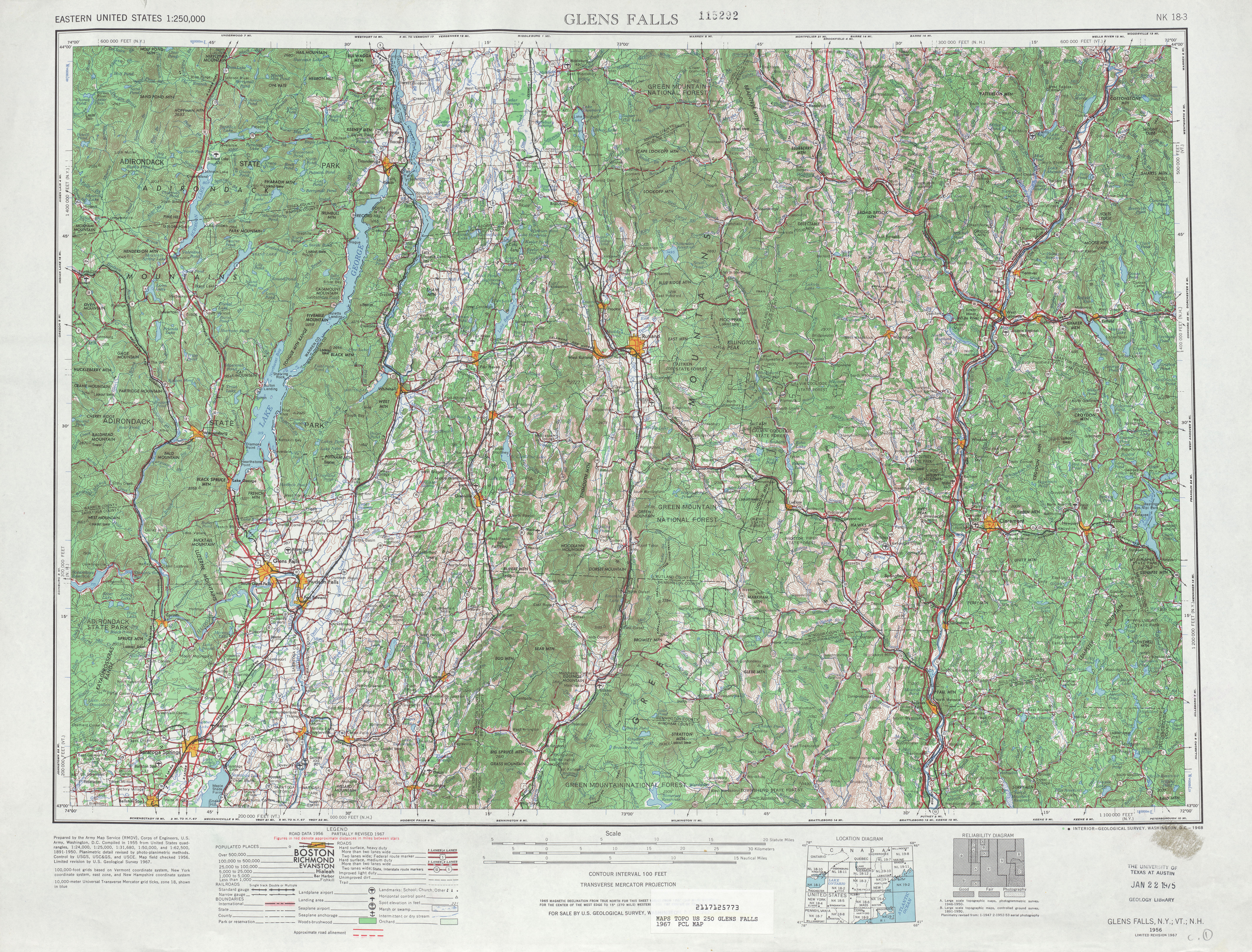
- ^ United States Geological Survey (1967). Glens Falls, NY Quadrangle (Topographic map). 1:250,000. Eastern United States 1:250,000. Reston, VA: United States Geological Survey. Retrieved December 7, 2007.
- ^ Esso; General Drafting (1968). New York (Map) (1969–70 ed.). 1:1,687,000. Convent Garden, NJ: General Drafting.[full citation needed]
- ^ a b New York State Department of Transportation (1989). Dover Plains Digital Raster Quadrangle (Topographic map). 1:24,000. Albany: New York State Department of Transportation. Archived from the original on December 19, 2014. Retrieved January 20, 2010.
- ^ "County Road 81, Wassaic" (Map). Google Maps. Retrieved February 25, 2016.
- ^ "Overview Map of Dutchess CR 5 (Old Route 22)" (Map). Google Maps. Retrieved July 11, 2008.
- ^ "Overview Map of Putnam County Road 50" (Map). Google Maps. Retrieved July 11, 2008.
- ^ New York State Department of Transportation (January 2017). Official Description of Highway Touring Routes, Bicycling Touring Routes, Scenic Byways, & Commemorative/Memorial Designations in New York State (PDF). Retrieved January 9, 2017.
- ^ United States Geological Survey (1953). Copake Quadrangle: New York–Massachusetts (Topographic map). 1:24,000. 7.5 Minute Series. Reston, VA: United States Geological Survey. Archived from the original on December 19, 2014. Retrieved July 11, 2008.
- ^ New York State Legislature. "New York State Highway Law § 341". Retrieved March 29, 2010.
- ^ New York State Department of Economic Development, Division of Tourism; Map Works (2007). I Love New York's 30th Anniversary Map (Map). [c. 1:775,000]. Albany: New York State Department of Economic Development, Division of Tourism. OCLC 123904093.[full citation needed]
- ^ New York State Department of Economic Development, Division of Tourism; Map Works (2009). New York State Map (Map). [c. 1:775,000]. Albany: New York State Department of Economic Development, Division of Tourism. OCLC 505217389.[full citation needed]
- ^ Esso; General Drafting (1942). New York with Pictorial Guide (Map). Esso.[full citation needed]
- ^ United States Army Corps of Engineers; United States Geological Survey (1944). New York–Vermont: Granville Quadrangle (Topographic map). 1:24,000. 7.5 Minute Series. Reston, VA: United States Geological Survey. Archived from the original on December 19, 2014. Retrieved May 3, 2009.
External links
[edit]- New York State Route 22 at Alps' Roads • New York Routes
- NY 22 Travelogue @ Empire State Roads
- NY 22 (East Coast Roads)
New York State Route 22
View on GrokipediaRoute description
The Bronx to Kensico Dam
New York State Route 22 begins at its southern terminus, an at-grade intersection with U.S. Route 1 (US 1, also known as Boston Road) at East 233rd Street in the Eastchester neighborhood of the Bronx, adjacent to the Bronx Zoo and the southern end of the Bronx River Parkway.[4] As Provost Avenue, the route heads north as a four-lane divided highway through the eastern Bronx, crossing the Bruckner Expressway (Interstate 278) and passing to the east of Pelham Bay Park, the city's largest public park. After intersecting the Hutchinson River Parkway, NY 22 crosses into Westchester County near the New England Thruway (Interstate 95) and enters the village of Pelham Manor, where it becomes Boston Post Road. In this initial 0.20-mile Bronx segment, annual average daily traffic (AADT) volumes reached approximately 14,500 vehicles in 2014.[5] Upon entering Westchester County, NY 22 continues north through densely urbanized areas as Boston Post Road (also known as Post Road in some sections), passing Metro-North Harlem Line stations that serve commuters to New York City. The route traverses the cities of New Rochelle and Mount Vernon, then the village of Eastchester, with AADT volumes around 20,500 vehicles near New Rochelle in 2014.[5] It crosses the Hutchinson River Parkway again in the village of Mamaroneck, continuing through the adjacent villages of Larchmont and the city of Rye, where commercial density is high along the corridor, including shopping districts and pedestrian-friendly sidewalks. In Rye, the route briefly turns west onto Theodore Fremd Avenue and north onto Purchase Street before resuming its northward trajectory on Boston Post Road, paralleling the Connecticut state line to the east. These urban stretches feature numerous local road interactions and support vibrant downtown areas with retail and residential development. North of Rye, NY 22 enters more suburban terrain in the village of Scarsdale as Post Road, turning north onto Popham Road before rejoining Post Road and proceeding to the city of White Plains. In White Plains, it becomes North Broadway, crossing the Cross Westchester Expressway (I-287) amid office parks, commercial centers, and additional Metro-North stations; AADT here approached 23,700 vehicles in 2014.[5] Beyond White Plains, the route enters the town of North Castle as Saw Mill River Road, then shifts northeast onto Route 22, passing west of the Kensico Reservoir. This approximately 25-mile Westchester segment sees AADT volumes generally ranging from 11,000 to 23,000 vehicles, reflecting its role as a key commuter artery.[6][5] The segment concludes near Kensico Dam, a critical component of New York City's water supply system that impounds the Kensico Reservoir for distribution to over 10 million residents. At Kensico Circle, NY 22 intersects NY 120A (Kensico Road), providing access to Kensico Dam Plaza, a county park with scenic overlooks and recreational facilities adjacent to the 307-foot-high masonry dam completed in 1915.[7] AADT near this northern endpoint was about 23,000 vehicles in 2014, with the route transitioning from suburban to more open settings amid the reservoir's wooded surroundings.[5] Throughout this 25-mile southern portion of NY 22, the highway maintains a north-south alignment close to the Connecticut border, serving as a vital link for local traffic, commuters, and regional travel.[6]Kensico Reservoir to Brewster
North of the Kensico Dam, NY 22 departs northward as a four-lane undivided road known as Mount Kisco Road, paralleling the eastern shore of Kensico Reservoir and the Bronx River through wooded and semi-rural landscapes in the town of Mount Pleasant, Westchester County.[8] The route crosses a bridge over an inlet of the reservoir before intersecting NY 120 (King Street) in Valhalla, where the two routes briefly multiplex for one block amid residential areas and light commercial development.[8] Traffic volumes in this initial stretch average around 22,000 vehicles per day, reflecting moderate suburban use.[9] Continuing northeast, NY 22 passes through the hamlet of Armonk in North Castle, where it becomes a four-lane divided highway with signalized intersections at Old Post Road, NY 128 (Main Street), and Business Park Drive, serving corporate offices and suburban neighborhoods.[8] An interchange with I-684 at exit 3 provides access to the northbound spur toward Connecticut, after which the route narrows to two lanes and enters more rural terrain with farms, forests, and low rolling hills in the town of Bedford.[8] Here, it intersects NY 124 (Bedford Road) amid scenic wooded areas, briefly multiplexes with NY 172 (Old Post Road), and transitions to Cantitoe Street and Jay Street through residential hamlets.[8] Average daily traffic drops to approximately 8,000–10,000 vehicles in these northern Westchester segments, emphasizing the shift to quieter rural driving.[9] Entering the town of Lewisboro, NY 22 winds through the hamlets of Cross River, Goldens Bridge, and Purdys as Goldens Bridge Road, characterized by a two-lane undivided alignment with occasional passing zones, stone walls, and views of forested hillsides and small farms.[8] It intersects NY 116 near Goldens Bridge and crosses the town line into Putnam County at Croton Falls, where it joins US 202 in a brief concurrency along the Croton River valley, offering glimpses of the Croton Falls Reservoir to the west.[10] The route features a bridge over the Croton River and passes through rural lowlands with scattered homes and limited services before reaching the hamlet of Brewster in the town of Southeast.[11] Key junctions include NY 121 and NY 312 near the village center, with an interchange at I-84 (exit 56) and the northern terminus of I-684; traffic volumes near Brewster average about 17,000 vehicles per day.[11][12] This approximately 20-mile segment highlights a transition from reservoir-adjacent suburbs to pastoral countryside, maintained as a winding rural highway with minimal urban influences.[13]Harlem Valley, Taconics, and Berkshires
Upon entering Dutchess County just north of Brewster, NY 22 ascends gradually into the Harlem Valley, a broad, fertile lowland characterized by open farmlands and occasional wetlands, with scenic views of Wassaic Creek paralleling the route to the west.[14][10] The highway passes through small hamlets like Wingdale, Dover Plains, and Wassaic, where historic railroad stations and remnants of 19th-century ironworks, such as Dover Furnace, dot the landscape amid rolling pastures and low hills separating the valley from the Connecticut border.[10] This segment offers a transition from the more developed southern portions of the route to the rural, agricultural heart of eastern Dutchess, with the road maintaining a mostly straight alignment through grassy fields before tightening into gentler curves as it approaches the Taconic foothills.[14] Further north, NY 22 intersects NY 44 (also carrying U.S. Route 44) in the village of Millerton, where the routes briefly overlap before NY 44 diverges westward toward Millbrook.[10] Beyond Millerton, the highway crosses the Taconic State Parkway via an overpass and begins a more pronounced ascent into the Taconic Mountains, featuring winding alignments, tight curves, and sections of steep grades that challenge drivers amid dense forests and elevated terrain.[10] The route climbs through the southern Taconics, passing near Taconic State Park's Copake Falls area, which includes access to Bash Bish Falls—a 60-foot cascade on the New York-Massachusetts border accessible via NY 344—and supports diverse wildlife habitats with recent state initiatives for crossings to mitigate vehicle collisions.[15][16] In Columbia County, NY 22 continues northward through the towns of Ancram and Hillsdale, closely paralleling the Massachusetts state line while traversing narrow valleys flanked by the eastern escarpment of the Taconics.[17] The roadway winds past preserved farmlands, stone walls, and small communities like Copake Falls and Austerlitz, emphasizing the region's agricultural heritage with fields of corn, hay, and livestock under the shadow of wooded ridges.[10] The Harlem Valley Rail Trail, a 26-mile multi-use path built on the former New York and Harlem Railroad corridor, runs adjacent to NY 22 for much of this stretch, providing recreational connectivity through wetlands, rivers, and historic bridges.[18][15] Entering Rensselaer County, NY 22 navigates the Berkshire Hills, a southern extension of the broader Appalachian system, with continued elevation changes and serpentine paths through the towns of Stephentown, Berlin, and Petersburg.[19] Here, the route concurs with NY 43 for approximately 1 mile in Stephentown, sharing a brief alignment before NY 43 veers southeast toward the Massachusetts line, while NY 22 proceeds north toward the Troy area and the transition to flatter farmlands.[19] This central segment spans roughly 60 miles across the three counties, serving as a scenic alternative to the busier Interstate 87 to the west, with average daily traffic volumes ranging from 5,000 to 15,000 vehicles, peaking near population centers like Millerton and Hoosick Falls.[14][17][19] The area's proximity to protected lands in Taconic State Park enhances its appeal for eco-tourism, though the combination of curves and grades requires cautious navigation, particularly for trucks accessing regional farms and parks.[20][10]Washington County
NY 22 enters Washington County from Rensselaer County in the town of Cambridge, continuing northward through rural landscapes characterized by gently rolling farmlands and open agricultural plains close to the Vermont state line.[10] The highway parallels the border, offering occasional views of the Green Mountains across the state line, and passes through small villages amid a prevalence of dairy farms that define the region's economy and scenery.[21] In Cambridge, the route intersects NY 372, providing access to nearby Greenwich via local roads.[22] North of Cambridge, NY 22 proceeds to Salem, where it meets the northern terminus of NY 29 at an at-grade intersection south of the village center. The highway runs near the Batten Kill River in this area, with nearby covered bridges like the Rexleigh and Shushan spans crossing the waterway, enhancing the rural charm of the agricultural surroundings.[22] Flat farmlands dominate the terrain, supporting extensive dairy operations, and the route remains mostly straight as a two-lane road with shoulders, carrying typical daily traffic volumes of 4,000 to 10,000 vehicles.[23] Landmarks along or near the path include Revolutionary War sites in the county, such as the historic area around Fort Edward to the west, reflecting the region's role in early American history.[24] Continuing north, NY 22 reaches Granville, where it intersects NY 149 at the southern edge of the village, briefly providing a more urban feel amid local businesses before turning westward toward Hebron and Fort Ann.[10] The segment spans approximately 73 miles through Washington County—the longest portion of the route in any single county—transitioning from eastern border farmlands to areas approaching the southern edges of the Adirondack Park near Fort Ann and Dresden.[25] In Fort Ann, the highway meets US 4, joining it briefly northward through Whitehall, where it passes the Champlain Canal and nears South Bay, an inlet of Lake Champlain, before entering Essex County.[10] The Washington County Fairgrounds, located nearby in Greenwich, host annual events that draw visitors from along the route.[26]Adirondack Park and Lake Champlain
New York State Route 22 enters the Adirondack Park near the village of Ticonderoga in Essex County, where it crosses the La Chute River, the outlet of Lake George, and passes close to the historic Fort Ticonderoga, a key Revolutionary War site overlooking the lake.[27][28] The route here transitions from the more open landscapes of Washington County into the protected boundaries of the 6.1-million-acre Adirondack Park, marked by the park's "Blue Line" perimeter, which encompasses vast public and private lands subject to strict environmental regulations. North of Ticonderoga, NY 22 follows a winding path through the town of Crown Point and the village of Port Henry, hugging the eastern shore of Lake Champlain and offering glimpses of the lake's expansive waters and the distant Green Mountains of Vermont.[29] The highway traverses forested terrain with limited commercial development, owing to Adirondack Park Agency land use classifications that prioritize resource management and restrict intensive building in rural and wild forest zones along this corridor. In Port Henry, NY 22 briefly concurs with NY 9N for approximately 14 miles northward to Westport, providing access to lakeside communities and scenic viewpoints, including overlooks of the Essex-Charlotte Ferry crossing Lake Champlain.[29][30] Key landmarks along this stretch include the Crown Point State Historic Site, featuring ruins of 18th-century French and British forts with interpretive trails and museum exhibits on colonial military history, located just off NY 22 near the lake.[31] The route also borders Adirondack wilderness areas, such as portions of the Dix Mountain Wilderness, supporting diverse wildlife habitats for species like black bears, moose, and migratory birds, while boating access points at Crown Point Campground provide public launches for Lake Champlain recreation.[32][33] Spanning approximately 50 miles through this northeastern section of the park, NY 22 experiences low traffic volumes, typically ranging from 2,000 to 3,000 vehicles per day based on counts near Ticonderoga and Port Henry, reflecting its role as a quiet scenic corridor rather than a major thoroughfare.[29] Designated as part of the Lakes to Locks Passage National Scenic Byway, the route features designated pull-offs for viewpoints, enhancing its appeal for leaf-peeping in fall and wildlife observation year-round.[34] Seasonal tourism surges during summer boating season and winter access to nearby snowmobile trails, but park regulations help mitigate impacts on sensitive habitats like shoreline wetlands and upland forests.[35][36]Clinton County
NY 22 enters Clinton County from Essex County near the village of Keeseville, where it joins U.S. Route 9 (US 9) in a short concurrency before diverging northward. The route passes through the rural hamlet of Peru, intersecting New York State Route 22B (NY 22B), a short spur to Schuyler Falls and Morrisonville near Clinton County Airport, and NY 442 toward Lake Champlain. Continuing north, NY 22 approaches the outskirts of Plattsburgh, the county seat and northeasternmost city in New York, where it intersects US 9 again and has multiple access points to Interstate 87 (I-87), including exits for local streets like Durant Road and Boynton Avenue. In Plattsburgh, the highway crosses the Saranac River via the Court Street Bridge and meets NY 374 heading west to the Adirondack Mountains. Beyond the city, NY 22 shifts to a more rural character, traversing the town of Beekmantown and intersecting NY 456 near the community center, before entering the town of Chazy.[37][2] North of Chazy, the route passes through West Chazy, a small agricultural hamlet, and intersects NY 191 (Alexandria Alice Road) near Sciota. As it nears its conclusion, NY 22 enters the town of Mooers, crossing the Great Chazy River—a tributary flowing to Lake Champlain—shortly before reaching the village of Mooers. Here, amid farmlands and scattered residences, the highway ends at a junction with US 11 (Main Street/Champlain Street), marking the northern terminus of NY 22. The segment in Clinton County measures approximately 33 miles, serving as a key link between the Adirondack region's wilderness and the flat, fertile plains adjacent to the international border. Daily traffic along this stretch typically ranges from 3,000 to 8,000 vehicles, with higher volumes near Plattsburgh and lower in rural areas; truck routes around the city help manage commercial flow, while proximity to border crossings can lead to occasional delays from customs processing.[37][38][10] The northern endpoint in Mooers lies just 3.75 miles south of the Canada–United States border, where a former extension of NY 22 once reached the Mooers–Hemmingford port of entry, now maintained as County Route 57 and connecting to Quebec Route 219. This rural borderland features bilingual signage and communities with deep Franco-American roots, stemming from 19th-century French-Canadian immigration that shaped local agriculture, mills, and cultural institutions in towns like Chazy and Mooers. Nearby, the Champlain border crossing—handling major traffic to Quebec Route 202 and Montreal—serves as the primary international gateway, supplemented by alternatives such as the Alburg–Swanton ferry across Lake Champlain in Vermont for regional connectivity. From its origin in the Bronx to Mooers, NY 22 spans a total of 337.54 miles (543.22 km), the longest north–south state highway in New York.[2][39]History
Early development and old roads
The route of modern New York State Route 22 traces its origins to ancient Native American trails utilized by tribes including the Lenape, Wackquaskeck, and Siwanoy for travel and trade along the Bronx River and through Westchester County. These paths were adopted by Dutch settlers in the mid-17th century, who improved them for transporting goods to New Amsterdam after acquiring land from local tribes in 1639. English colonists further developed the trails following the 1654 purchase of the area by Thomas Pell, establishing them as key connectors between settlements.[40] In the 18th century, the southern portion of the route evolved as part of the Upper Post Road, a branch of the Boston Post Road system designated for mail delivery between New York City and Boston, passing through White Plains and known locally as the White Plains Post Road or the Road to Bedford and Vermont. Post-Revolutionary War, it became a vital stagecoach route for travelers and cattle drovers, supporting taverns and commerce amid landmarks like St. Paul’s Church in Mount Vernon and the Bedford courthouse. British and colonial troops utilized the path during the 1776 White Plains campaign, highlighting its strategic importance.[41][42] The 19th century saw significant enhancements through private turnpike companies, with the Dutchess Turnpike chartered in 1802 to link Poughkeepsie eastward to Dover and Sharon, Connecticut, facilitating agricultural transport paralleling sections of the future NY 22 in Dutchess County. In the northern reaches, early roads along the Lake Champlain shoreline, part of the Champlain Valley corridor, were improved as frontier paths connecting Albany to Canada, chartered under turnpikes like the 1799 Columbia Turnpike extensions for commerce and settlement. The 1825 completion of the Erie Canal spurred parallel road upgrades in eastern New York, including plank roads in Westchester and Dutchess counties for faster local travel, alongside early bridges over streams. By the 1810s, federal mail contracts drove further improvements, such as widening and surfacing for reliable delivery. However, by the 1850s, most turnpikes were abolished or converted to free public roads as railroads, including the New York and Harlem Railroad, rendered them obsolete.[43][44][45] Regionally, the route exhibited stark variations: in the south, urban paths through the Bronx and Westchester supported dense settlement and trade with New York City, while northern sections in Washington and Clinton counties remained rugged frontier roads, aiding migration and military movements toward the Canadian border via Lake Champlain. This duality reflected broader patterns of colonial expansion, with southern segments benefiting from proximity to ports and northern ones serving as gateways to remote lands.[42][45]Designation and public ownership
The designation of New York State Route 22 occurred in 1924 as part of the state's first systematic numbering of major highways under Chapter 25 of the Consolidated Laws, known as the Highway Law. This legislative action assigned numeric designations to the unsigned legislative routes established earlier, with NY 22 primarily following legislative route 1 from the Bronx northward through the Hudson Valley, Taconic Mountains, and Champlain Valley to Mooers near the Canadian border. The initial routing incorporated segments of former county-maintained roads and totaled approximately 320 miles, marking it as one of the longest state highways at the time.[46] The shift to public ownership and control of these roads was facilitated by the Highway Law of 1909, which created the New York State Department of Highways and empowered the state to acquire private and county roads for inclusion in the new state system. Between 1909 and 1926, the state systematically purchased and converted numerous private turnpikes—remnants of 19th-century toll roads that had served as precursors to modern highways—along with other key segments, eliminating tolls and placing them under state maintenance to ensure uniform standards and accessibility.[47] Signage for the newly numbered routes, including NY 22, was implemented in 1926 using durable cast-iron markers with a yellow band and black borders, aligning with emerging national guidelines from the American Association of State Highway Officials (AASHTO). The southern terminus was adjusted slightly from its original overlap with the US 1 alignment in the Bronx for better integration, while the northern extension reached the international border area at Champlain, connecting to Quebec Route 223. These efforts were funded through state-issued bonds and matching federal grants introduced by the Federal Aid Road Act of 1916, which provided initial appropriations of $75 million nationwide to support state-led improvements.Mid-20th century changes and concurrencies
In the 1930 renumbering of state highways in New York, NY 22 was extended northward from Granville along former NY 24 and NY 30 alignments to the Clinton County line near Mooers, with a concurrency established with the newly created NY 9N from Ticonderoga to Port Henry to facilitate lakefront access along Lake Champlain. This overlap provided a direct connection for travelers between the Adirondack interior and the lake's eastern shore, reflecting the state's effort to integrate local roads into a cohesive numbered system. The NY 9N designation replaced earlier routes like NY 9W, emphasizing improved signage and connectivity for north-south travel in Essex County.[48] Post-World War II improvements focused on modernizing NY 22 to handle increasing automobile traffic. In Westchester County during the 1950s, sections were widened to accommodate suburban growth, with the state assuming responsibility for condemned bridges and road expansions as part of regional connectivity efforts.[49] In the Adirondacks, paving projects in the 1940s upgraded unpaved segments to bituminous surfaces, improving access through remote areas like Essex County and supporting tourism and logging industries.[49] The construction of Interstate 87 (the Adirondack Northway) in the 1960s, beginning in 1957 and completing in 1967, ran parallel to NY 22 in several areas, diverting long-haul traffic northward and reducing congestion on the state route.[49] This shift notably decreased truck volumes on southern sections of NY 22, as I-87 became the preferred corridor for Albany-to-Canada travel. Key supporting events included the 1938 extension of NY 9N southward to Ticonderoga, enhancing the concurrency's utility, and 1950s upgrades to bridges over Hudson River tributaries in Columbia County, such as structural reinforcements for heavier loads.[49] These modifications collectively transformed NY 22 from a primary artery to a more local and scenic route.Realignments and improvements
During the 1990s, safety enhancements in Putnam County focused on straightening curves near Brewster to improve visibility and reduce accident rates along the busy corridor south of the I-84 interchange. These modifications included minor realignments and pavement upgrades to accommodate increasing commuter and truck traffic from the New York City metropolitan area. NYSDOT's efforts emphasized geometric improvements to the two-lane highway, enhancing overall safety without widening the roadway. The 2000s saw several bridge and culvert rehabilitations along NY 22 in Dutchess County and Essex County to address structural deficiencies and improve resiliency. In Dutchess County, projects rehabilitated structures over Wassaic Creek, Swamp River, and Bash Bish Brook, incorporating modern drainage systems to mitigate flooding risks. In Essex County, a 2001 culvert replacement over Tannery Brook in the Town of Essex restored hydraulic capacity and protected the roadway from erosion. Additionally, the 2005 NY 22/44 realignment in Millbrook, part of the Dutchess County Route 22 Access Management Study, optimized the intersection geometry for better traffic flow and safety, including acceleration lanes and shared driveways. The study also recommended addition of bike lanes and multi-use paths in the Harlem Valley section between Dover Plains and Millerton to support recreational use and pedestrian connectivity, with landscaped buffers to protect wetlands in the Taconics region through stream relocations and erosion control measures. In the 2010s, NYSDOT prioritized ADA compliance upgrades and shoulder additions in Westchester County to enhance accessibility and bicycle safety. Projects included reconstructing sidewalks and curb ramps along northern sections of NY 22, such as from Main Street to the Route 20/22 intersection, ensuring compliance with federal standards for pedestrian access. Shoulder widening and resurfacing from Route 120 to Middle Patent Road in North Castle added paved shoulders for cyclists and emergency vehicles. A 2018 study for a potential Hudson Falls bypass in Washington County evaluated options to relieve congestion but was not implemented due to environmental and cost concerns. These efforts collectively improved the route's infrastructure while balancing environmental protections, such as wetland mitigations in the Taconics through vegetative buffers and stormwater management.Recent developments
In 2024, the New York State Department of Transportation (NYSDOT) completed the replacement of the bridge carrying NY 22 over the Boquet River in the Town of Essex, Essex County, at a cost of $3.4 million. The project involved demolishing a 91-year-old structure that had reached the end of its useful life and constructing a new single-span steel girder bridge to improve safety and resiliency. The road was closed to traffic from mid-March to early November 2024 to facilitate the work.[50][51] Also in 2024, Dutchess County Department of Public Works replaced Bridge D-66 on Old State Route 22 (County Route 6) over the Swamp River in the Town of Dover, enhancing structural integrity and adding pedestrian accommodations including a 5-foot-wide sidewalk. The project addressed deterioration in the aging span and included widening for safer shoulders; the bridge reopened to traffic by late 2024 after construction began in spring.[52][53] In April 2025, NYSDOT initiated a $3.8 million project to replace the bridge carrying NY 22 over White Creek in the Town of White Creek, Washington County, with work expected to conclude by December 2025. The effort aims to eliminate structural deficiencies and enhance load capacity for modern traffic demands.[54] The Town of Southeast continued its Route 22 Master Plan and associated zoning updates through 2024 and into 2025, focusing on regulating land development along the corridor from the northern terminus of Interstate 684 to the Town of Pawling boundary. These measures seek to balance commercial growth with environmental preservation and traffic management in this high-growth area.[55] Looking ahead, NYSDOT and federal partners plan enhancements to border facilities near the northern terminus of NY 22 in Mooers, including upgrades to inspection infrastructure to support increased cross-border traffic, as part of broader northern border security initiatives. Additionally, the Regional Office of Sustainable Tourism is incorporating improved signage along NY 22 within the Adirondack Park to promote key attractions and boost visitor navigation starting in 2025.[56]Route features
Major intersections
The major intersections along New York State Route 22 are listed below in a table ordered by milepost from south to north, based on the official route log. The table includes all significant at-grade and grade-separated junctions with other state, U.S., and interstate highways, as well as key county roads where they represent major connectivity points. Mileposts are measured from the southern terminus in the Bronx. Notes indicate concurrencies, termini, or interchange types where applicable. This serves as a reference for the route's connectivity across its 337.57-mile length.[2][4][6][17][19][23][29]| Milepost | Location | Intersecting Route(s) | Notes |
|---|---|---|---|
| 0.00 | Bronx (Eastchester) | US 1 | Southern terminus; at-grade |
| 0.16 | Bronx (Eastchester) | East 233rd Street | Local road; at-grade |
| 1.39 | Bronx (Bronx Park East) | NY 907H (Pelham Parkway) | At-grade |
| 4.21 | Bronx/Westchester line | I-95 (New England Thruway) | Grade-separated interchange |
| 5.26 | Yonkers | NY 907K (Cross County Parkway) | Grade-separated |
| 9.16 | White Plains | NY 119 / NY 125 | At-grade; concurrency with NY 119 begins |
| 12.48 | White Plains | I-287 (Cross Westchester Expressway) | Grade-separated |
| 19.72 | North Castle | NY 684 | Grade-separated |
| 22.50 | North Castle | I-287 | Grade-separated (northern terminus of concurrency) |
| 27.02 | Bedford | NY 121 | At-grade |
| 31.89 | Bedford | NY 35 | At-grade |
| 34.04 | Lewisboro | NY 138 | At-grade |
| 39.01 | Lewisboro/Putnam line | Putnam County line | County boundary; at-grade continuations |
| 42.30 | Southeast | US 6 / NY 312 | At-grade |
| 52.30 | Southeast (Brewster) | I-84 / NY 312 | Grade-separated interchange |
| 57.80 | Southeast | NY 164 | At-grade |
| 65.10 | Kent | Taconic State Parkway | Grade-separated |
| 70.50 | Pawling | NY 55 | At-grade; brief concurrency |
| 78.20 | Dover Plains | NY 343 | At-grade |
| 85.40 | Millbrook | NY 44 | At-grade |
| 90.10 | Stanford | NY 82 | At-grade |
| 98.70 | Pine Plains | NY 199 | At-grade |
| 110.20 | Ancram | NY 43 | At-grade |
| 115.80 | Hillsdale | NY 23 | At-grade; concurrency begins (2 miles) |
| 118.60 | Hillsdale | NY 23 | End of concurrency |
| 122.40 | New Lebanon | I-90 (Berkshire Connector) / Taconic State Parkway | Grade-separated |
| 130.50 | Stephentown | NY 43 | At-grade |
| 135.20 | Nassau | NY 66 | At-grade |
| 140.80 | Berlin | NY 22A (suffixed, but mainline crossing) | At-grade |
| 145.10 | Hoosick | NY 7 | At-grade |
| 150.30 | Hoosick Falls | NY 67 | At-grade |
| 155.90 | Pittstown | NY 376 | At-grade |
| 162.40 | Easton | VT 153 (at NY/VT line) | At-grade; state line crossing |
| 170.20 | Greenwich | NY 29 | At-grade |
| 175.80 | Schuylerville | NY 32 / NY 372 | At-grade; concurrency with NY 29 ends |
| 180.50 | Saratoga Springs | US 9 / NY 29 | At-grade; major junction |
| 185.10 | Wilton | I-87 (Adirondack Northway) | Grade-separated |
| 190.70 | Corinth | NY 9N | At-grade |
| 200.40 | Kingsbury | NY 149 | At-grade |
| 205.20 | Fort Ann | NY 4 | At-grade; concurrency begins (brief) |
| 210.80 | Bolton Landing | NY 9N | At-grade; concurrency begins (5 miles) |
| 215.80 | Bolton Landing | NY 9N | End of concurrency |
| 220.50 | Ticonderoga | NY 74 | At-grade |
| 228.10 | Crown Point | NY 9N / NY 74 | At-grade; major lake access |
| 235.40 | Elizabethtown | NY 9 | At-grade |
| 240.20 | Lewis | NY 9 | At-grade; concurrency begins (3 miles) |
| 243.20 | Lewis | NY 9 | End of concurrency |
| 248.70 | Keene | NY 73 | At-grade |
| 255.10 | Au Sable Forks | NY 9N | At-grade; concurrency begins (2 miles) |
| 257.10 | Au Sable Forks | NY 9N | End of concurrency |
| 265.40 | Peru | I-87 | Grade-separated |
| 270.20 | Schuyler Falls | NY 190 | At-grade |
| 275.80 | Plattsburgh | NY 3 / NY 9 | At-grade; concurrency with NY 3 begins |
| 280.10 | Plattsburgh | NY 9N | At-grade; concurrency begins (5 miles) |
| 285.10 | Plattsburgh | NY 9N | End of concurrency |
| 337.57 | Mooers | US 11 | Northern terminus; at-grade |