Recent from talks
Protector Shoal
Knowledge base stats:
Talk channels stats:
Members stats:
Protector Shoal
Protector Shoal is the shallowest point of the Protector Seamounts, a group of submarine volcanoes in the Southern Ocean. They are part of the South Sandwich island arc, a volcanic arc that has given rise to the South Sandwich Islands. Protector Shoal reaches a depth of 55 metres (180 ft) below sea level and is part of a larger group of seamounts that formed atop a larger ridge. Some of these seamounts bear traces of sector collapses, and one is capped by nested calderas.
The seamount erupted in 1962, probably during March, and produced a large pumice raft that was swept by ocean currents around Antarctica. Various islands near to or in the Southern Ocean, such as Australia and New Zealand, have had Protector Shoal pumice wash up on their coastlines. Pumice attributed to this eruption has been recovered as far as Hawaii. There have been no eruptions since, but there is ongoing seismicity and underwater hydrothermal venting.
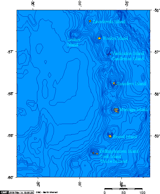
The Protector Seamounts are a 55 kilometres (34 mi) east-west trending ridge at 1,000–1,500 metres (3,300–4,900 ft) depth about 56 kilometres (35 mi) northwest of Zavodovski Island. They lie at the northern end of the South Sandwich Islands, a 350-kilometre (220 mi) long north-south trending chain of eleven islands at the eastern margin of the Scotia Sea. From north to south they include Zavodovski Island, Leskov Island, Visokoi Island, Candlemas Island-Vindication Island, Saunders Island, Montagu Island, Bristol Island and Southern Thule (Bellingshausen Island-Cook Island-Thule Island); they are small, lack vegetation and are heavily glaciated. Submarine volcanoes lie at each end of the chain: Protector at the northern, Nelson and Kemp at the southern. The seamount was already known before the 1962 eruption, but received a name only after the eruption.
The northern slopes of the common ridge have a low gradient and are cut by numerous faults associated with the subduction process. The southern slopes are less regular and steeper. Bisco Basin, a 20-kilometre (12 mi) wide embayment, lies north of the ridge. It was originally interpreted as a caldera or a sector collapse scar, but appears to be of tectonic origin. The Nimrod Basin is another tectonic depression. A southeastward extension of the ridge joins Protector Shoal with Zavodovski Island.
The ridge is topped by about seven distinct seamounts that are referred to in the literature as: Tula ("PS1"), Biscoe ("PS2"), "PS3", Protector Shoal ("PS4"), Endurance ("PS5"), JCR ("PS6") and Quest ("PS7"). The names refer to ships. Another seamount, Scoresby, was discovered west of Quest. The seamounts have the sizes of small stratovolcanoes, with heights of about 400–1,400 metres (1,300–4,600 ft), and rise to about a few hundred metres below sea level. The shallowest point of the chain is Protector Shoal which reaches a depth of 55 metres (180 ft) below sea level. Initially it was thought that "Protector Shoal" was a 27-metre (89 ft) deep seamount; subsequently the name was attributed to the shallowest seamount. This seamount is cut by a 2.5-kilometre (1.6 mi) wide slump scar, formed by a collapse that descended to the south-southeast. Another slump is identified on the northwestern side.
Northwest of Protector Shoal is the broad Nimrod Bank, at 400–600 metres (1,300–2,000 ft) depth. JCR also features a collapse scar. Quest is cut by two 3 kilometres (1.9 mi) and 1.6 kilometres (0.99 mi) wide nested calderas that are breached to the southwest, with a maximum depth of 340 metres (1,120 ft). The caldera volume reaches about 0.4–0.9 cubic kilometres (0.096–0.216 cu mi). Lava domes and lava flows, probably from monogenetic volcanoes, have been emplaced south of JCR and west of Nimrod Bank. Dives on to Quest and Protector Shoal have found a seafloor covered with gravel, sediments, talus and volcanic blocks that reach metre sizes. Some areas are sandy, others blocky or gravelly and there are rocky outcrops at Protector and Scoresby.
East of the South Sandwich Islands, the South American Plate subducts beneath the Sandwich Plate at a rate of about 67–79 millimetres per year (2.6–3.1 in/year), increasing to the south. This subduction is responsible for the volcanism of the South Sandwich arc. The oceanic crust under the arc is young, only about 8–10 million years, and formed on the Scotia spreading ridge west of the South Sandwich Islands. It is a young volcanic arc which produces mainly basaltic rocks, forming 3-kilometre (1.9 mi) high volcanic piles.
At the northern margin of the arc, the subducted oceanic crust is about 76 million years old. Below Protector Shoal, the downgoing South America slab has an east-west trending tear. Fluids ascending through the tear could be enhancing melt production under the seamount.
Hub AI
Protector Shoal AI simulator
(@Protector Shoal_simulator)
Protector Shoal
Protector Shoal is the shallowest point of the Protector Seamounts, a group of submarine volcanoes in the Southern Ocean. They are part of the South Sandwich island arc, a volcanic arc that has given rise to the South Sandwich Islands. Protector Shoal reaches a depth of 55 metres (180 ft) below sea level and is part of a larger group of seamounts that formed atop a larger ridge. Some of these seamounts bear traces of sector collapses, and one is capped by nested calderas.
The seamount erupted in 1962, probably during March, and produced a large pumice raft that was swept by ocean currents around Antarctica. Various islands near to or in the Southern Ocean, such as Australia and New Zealand, have had Protector Shoal pumice wash up on their coastlines. Pumice attributed to this eruption has been recovered as far as Hawaii. There have been no eruptions since, but there is ongoing seismicity and underwater hydrothermal venting.
The Protector Seamounts are a 55 kilometres (34 mi) east-west trending ridge at 1,000–1,500 metres (3,300–4,900 ft) depth about 56 kilometres (35 mi) northwest of Zavodovski Island. They lie at the northern end of the South Sandwich Islands, a 350-kilometre (220 mi) long north-south trending chain of eleven islands at the eastern margin of the Scotia Sea. From north to south they include Zavodovski Island, Leskov Island, Visokoi Island, Candlemas Island-Vindication Island, Saunders Island, Montagu Island, Bristol Island and Southern Thule (Bellingshausen Island-Cook Island-Thule Island); they are small, lack vegetation and are heavily glaciated. Submarine volcanoes lie at each end of the chain: Protector at the northern, Nelson and Kemp at the southern. The seamount was already known before the 1962 eruption, but received a name only after the eruption.
The northern slopes of the common ridge have a low gradient and are cut by numerous faults associated with the subduction process. The southern slopes are less regular and steeper. Bisco Basin, a 20-kilometre (12 mi) wide embayment, lies north of the ridge. It was originally interpreted as a caldera or a sector collapse scar, but appears to be of tectonic origin. The Nimrod Basin is another tectonic depression. A southeastward extension of the ridge joins Protector Shoal with Zavodovski Island.
The ridge is topped by about seven distinct seamounts that are referred to in the literature as: Tula ("PS1"), Biscoe ("PS2"), "PS3", Protector Shoal ("PS4"), Endurance ("PS5"), JCR ("PS6") and Quest ("PS7"). The names refer to ships. Another seamount, Scoresby, was discovered west of Quest. The seamounts have the sizes of small stratovolcanoes, with heights of about 400–1,400 metres (1,300–4,600 ft), and rise to about a few hundred metres below sea level. The shallowest point of the chain is Protector Shoal which reaches a depth of 55 metres (180 ft) below sea level. Initially it was thought that "Protector Shoal" was a 27-metre (89 ft) deep seamount; subsequently the name was attributed to the shallowest seamount. This seamount is cut by a 2.5-kilometre (1.6 mi) wide slump scar, formed by a collapse that descended to the south-southeast. Another slump is identified on the northwestern side.
Northwest of Protector Shoal is the broad Nimrod Bank, at 400–600 metres (1,300–2,000 ft) depth. JCR also features a collapse scar. Quest is cut by two 3 kilometres (1.9 mi) and 1.6 kilometres (0.99 mi) wide nested calderas that are breached to the southwest, with a maximum depth of 340 metres (1,120 ft). The caldera volume reaches about 0.4–0.9 cubic kilometres (0.096–0.216 cu mi). Lava domes and lava flows, probably from monogenetic volcanoes, have been emplaced south of JCR and west of Nimrod Bank. Dives on to Quest and Protector Shoal have found a seafloor covered with gravel, sediments, talus and volcanic blocks that reach metre sizes. Some areas are sandy, others blocky or gravelly and there are rocky outcrops at Protector and Scoresby.
East of the South Sandwich Islands, the South American Plate subducts beneath the Sandwich Plate at a rate of about 67–79 millimetres per year (2.6–3.1 in/year), increasing to the south. This subduction is responsible for the volcanism of the South Sandwich arc. The oceanic crust under the arc is young, only about 8–10 million years, and formed on the Scotia spreading ridge west of the South Sandwich Islands. It is a young volcanic arc which produces mainly basaltic rocks, forming 3-kilometre (1.9 mi) high volcanic piles.
At the northern margin of the arc, the subducted oceanic crust is about 76 million years old. Below Protector Shoal, the downgoing South America slab has an east-west trending tear. Fluids ascending through the tear could be enhancing melt production under the seamount.
Recent media