
Community hub
Recent from talks
Contribute something
Nothing was collected or created yet.
Quasi-Zenith Satellite System
View on Wikipedia
| Country/ies of origin | Japan |
|---|---|
| Operator | Quasi-Zenith Satellite System Services Inc. / Cabinet Office |
| Type | Civilian |
| Status | Operational |
| Coverage | Regional |
| Accuracy | PNT <10 m (public) SLAS <1 m (public) CLAS <10 cm (public) |
| Constellation size | |
| Nominal satellites | 7 |
| Current usable satellites | 4 |
| First launch | 11 September 2010 |
| Last launch | 26 October 2021 |
| Total launches | 5 |
| Orbital characteristics | |
| Regime | 3x GSO |
| Other details | |
| Cost | JPY 170 billion |
| Website | qzss |


The Quasi-Zenith Satellite System (QZSS) (Japanese: 準天頂衛星システム, Hepburn: juntenchō eisei shisutemu), also known as Michibiki (みちびき, "guidance"), is a regional navigation satellite system (RNSS) and a satellite-based augmentation system (SBAS) developed by the Japanese government to enhance the United States-operated Global Positioning System (GPS) in the Asia-Oceania regions, with a focus on Japan.[1] The goal of QZSS is to provide highly precise and stable positioning services in the Asia-Oceania region, compatible with GPS.[2] Four-satellite QZSS services were available on a trial basis as of 12 January 2018,[3] and officially started on 1 November 2018.[4] A satellite navigation system independent of GPS is planned for 2023 with seven satellites.[5][6] In May 2023 it was announced that the system would expand to eleven satellites.[7]
History
[edit]In 2002, the Japanese government authorized the development of QZSS, as a three-satellite regional time transfer system and a satellite-based augmentation system (SBAS) for the United States operated Global Positioning System (GPS) to be receivable within Japan. A contract was awarded to Advanced Space Business Corporation (ASBC), that began concept development work, and Mitsubishi Electric, Hitachi, and GNSS Technologies Inc. However, ASBC collapsed in 2007, and the work was taken over by the Satellite Positioning Research and Application Center (SPAC), which is owned by four Japanese government departments: the Ministry of Education, Culture, Sports, Science and Technology, the Ministry of Internal Affairs and Communications, the Ministry of Economy, Trade and Industry, and the Ministry of Land, Infrastructure, Transport and Tourism.[8]
The first satellite "Michibiki" was launched on 11 September 2010.[9] Full operational status was expected by 2013.[10][11] In March 2013, Japan's Cabinet Office announced the expansion of QZSS from three satellites to four. The US$526 million contract with Mitsubishi Electric for the construction of three satellites was scheduled for launch before the end of 2017.[12] The third satellite was launched into orbit on 19 August 2017,[13] and the fourth was launched on 10 October 2017.[14] The basic four-satellite system was announced as operational on 1 November 2018.[4]
As of 2024[update], an eleven-satellite configuration is under consideration, which would provide redundancy for single-satellite failure.[15]
Orbit
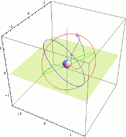
[edit]QZSS uses one geostationary satellite and three satellites in Tundra-type highly inclined, slightly elliptical, geosynchronous orbits. Each orbit is 120° apart from the other two. Because of this inclination, they are not geostationary; they do not remain in the same place in the sky. Instead, their ground traces are asymmetrical figure-8 patterns (analemmas), designed to ensure that one is almost directly overhead (elevation 60° or more) over Japan at all times.
The nominal orbital elements are:
| Epoch | 26 December 2009, 12:00 UTC |
| Semimajor axis (a) | 42,164 km (26,199 mi) |
| Eccentricity (e) | 0.075 ± 0.015 |
| Inclination (i) | 43° ± 4° |
| Right ascension of the ascending node (Ω) | 195° (initial) |
| Argument of perigee (ω) | 270° ± 2° |
| Mean anomaly (M0) | 305° (initial) |
| Central longitude of ground trace | 135° E ± 5° |
Planned seven satellites constellation consists of four Quasi-Zenith Orbit (QZO) satellites, two geostationary (GEO) satellites, and one quasi-geostationary (slight incline and eccentricity) orbit satellite.[17]
Satellites
[edit]| Name | Launch date | Launch Vehicle | Status | Notes |
|---|---|---|---|---|
| QZS-1 (Michibiki-1) | 11 September 2010 | H-IIA 202 | Replaced by QZS-1R | Experimental. Lacks MADOCA and PTV signals. Acting as spare since March 2022.[18] Decommissioned on 15 September 2023.[19] |
| QZS-2 (Michibiki-2) | 1 June 2017 | H-IIA 202 | Operational | Improved solar panels and increased fuel |
| QZS-3 (Michibiki-3) | 19 August 2017 | H-IIA 204 | Operational | Heavier design with additional S-band antenna on geostationary orbit at 127° E[17] |
| QZS-4 (Michibiki-4) | 10 October 2017 | H-IIA 202 | Operational | Improved solar panels and increased fuel |
| QZS-1R (Michibiki-1R) | 26 October 2021 | H-IIA 202 | Operational | Replacement for QZS-1.[20] |
| QZS-5 (Michibiki-5) | 7 December 2025 | H3-22S | Planned | [21] |
| QZS-6 (Michibiki-6) | 2 February 2025 | H3-22S | Operational | Geostationary at 90.5° E[17][22][21] |
| QZS-7 (Michibiki-7) | JFY2025 | H3 | Planned | Quasi-geostationary around 190° E[17][22] |


QZSS and positioning augmentation
[edit].webp)
The primary purpose of QZSS is to increase the availability of GPS in Japan's numerous urban canyons, where only satellites at very high elevation can be seen. A secondary function is performance enhancement, increasing the accuracy and reliability of GPS-derived navigation solutions. The Quasi-Zenith Satellites transmit signals compatible with the GPS L1C/A signal, as well as the modernized GPS L1C, L2C signal and L5 signals. This minimizes changes to existing GPS receivers. Compared to standalone GPS, the combined system GPS plus QZSS delivers improved positioning performance via ranging correction data provided through the transmission of submeter-class performance enhancement signals L1-SAIF and LEX from QZSS. It also improves reliability by means of failure monitoring and system health data notifications. QZSS also provides other support data to users to improve GPS satellite acquisition. According to its original plan, QZSS was to carry two types of space-borne atomic clocks; a hydrogen maser and a rubidium (Rb) atomic clock. The development of a passive hydrogen maser for QZSS was abandoned in 2006. The positioning signal will be generated by a Rb clock and an architecture similar to the GPS timekeeping system will be employed. QZSS will also be able to use a Two-Way Satellite Time and Frequency Transfer (TWSTFT) scheme, which will be employed to gain some fundamental knowledge of satellite atomic standard behavior in space as well as for other research purposes.
Signals and services
[edit]The QZSS provides the following classes of public service:[23]
- The PNT (positioning, navigation, and timing) service complements the signals used by the GPS, essentially acting as extra satellites. The QZSS satellites sync their clocks with GPS satellites. The service broadcasts at frequency bands L1C/A, L1C, L2C, and L5C, the same as GPS.[24]
- The SLAS (sub-meter level augmentation service) provides a form of GNSS augmentation for GPS interoperable with other GPS-SBAS systems. The principle of operation is similar to that of, e.g. Wide Area Augmentation System. It transmits on L1.[24]
- The CLAS (centimeter level augmentation service) provides high-precision positioning compatible with the higher-precision E6 service of Galileo. The band is referred to as L6 or LEX, for "experimental".[24]
- The MADOCA-PPP (Multi-GNSS Advanced Orbit and Clock Augmentation – Precise Point Positioning) service is a L6 augmentation service independent from CLAS.
- The DC Report (Satellite Report for Disaster and Crisis Management) service broadcasts on L1S and provides information on floods and earthquakes.
The other classes of service are not publicly available:
- The PTV (Positioning Technology Verification) service broadcasts on L5S. The documentation only describes a "null" message type.
- The Q-ANPI (QZSS Safety Confirmation Service) is an authorized short message service.
QZSS timekeeping and remote synchronization
[edit]Although the first generation QZSS timekeeping system (TKS) will be based on the Rb clock, the first QZSS satellites will carry a basic prototype of an experimental crystal clock synchronization system. During the first half of the two-year in-orbit test phase, preliminary tests will investigate the feasibility of the atomic clock-less technology which might be employed in the second generation QZSS.
The mentioned QZSS TKS technology is a novel satellite timekeeping system which does not require on-board atomic clocks as used by existing navigation satellite systems such as BeiDou, Galileo, Global Positioning System (GPS), GLONASS or NavIC system. This concept is differentiated by the employment of a synchronization framework combined with lightweight steerable on-board clocks which act as transponders re-broadcasting the precise time remotely provided by the time synchronization network located on the ground. This allows the system to operate optimally when satellites are in direct contact with the ground station, making it suitable for a system like the Japanese QZSS. Low satellite mass and low satellite manufacturing and launch cost are significant advantages of this system. An outline of this concept as well as two possible implementations of the time synchronization network for QZSS were studied and published in Remote Synchronization Method for the Quasi-Zenith Satellite System[25] and Remote Synchronization Method for the Quasi-Zenith Satellite System: study of a novel satellite timekeeping system which does not require on-board atomic clocks.[26][non-primary source needed]


See also
[edit]Other systems
[edit]- BeiDou – global navigation satellite system operated by China.
- Galileo – global navigation satellite system operated by the European Union.
- GLONASS – global navigation satellite system operated by Russia.
- GPS – global navigation satellite system operated by the United States.
- NavIC – regional navigation satellite system operated by India, receivable in the South Asia and Western Asia regions.
References
[edit]- ^ "Quasi-Zenith Satellite Orbit (QZO)". Archived from the original on 9 March 2018. Retrieved 10 March 2018.
- ^ "[Movie] Quasi-Zenith Satellite System "QZSS"". Quasi-Zenith Satellite System(QZSS). Archived from the original on 15 July 2017. Retrieved 19 July 2017.
- ^ "Start of QZS-4 Trial Service". Quasi-Zenith Satellite System (QZSS). Archived from the original on 10 August 2018. Retrieved 2 May 2018.
- ^ a b "Japan's QZSS service now officially available". 26 November 2018. Retrieved 11 January 2019.
- ^ "Japan mulls seven-satellite QZSS system as a GPS backup". SpaceNews. 15 May 2017. Retrieved 10 August 2019.
- ^ Kriening, Torsten (23 January 2019). "Japan Prepares for GPS Failure with Quasi-Zenith Satellites". SpaceWatch.Global. Retrieved 10 August 2019.
- ^ Kawahara, Satoshi (8 May 2023). "Japan plans expansion of homegrown GPS network to 11 satellites". Nikkei Asia.
- ^ "Service Status of QZSS" (PDF). 12 December 2008. Archived from the original (PDF) on 25 July 2011. Retrieved 7 May 2009.
- ^ "Launch Result of the First Quasi-Zenith Satellite "MICHIBIKI" by H-IIA Launch Vehicle No. 18". JAXA. 11 September 2010. Archived from the original on 20 March 2012. Retrieved 12 December 2011.
- ^ "QZSS in 2010". Asian Surveying and Mapping. 7 May 2009. Retrieved 7 May 2009.[dead link]
- ^ "GNSS All Over the World". GPS World Online. 1 November 2007. Archived from the original on 23 August 2011. Retrieved 12 December 2011.
- ^ http://www.spaceflightnow.com/news/n1304/04qzss/ Japan to build fleet of navigation satellites at the Wayback Machine (archived 2013-04-11)
- ^ "Launch Schedule". Archived from the original on 9 August 2018. Retrieved 20 August 2017.
- ^ "Launch Schedule". Spaceflight Now. Archived from the original on 16 August 2018. Retrieved 20 August 2017.
- ^ "National Space Policy Secretariat" 衛星測位に関する取組方針 2024 (PDF) (in Japanese). Cabinet Office, Government of Japan. 12 June 2024.
- ^ Interface Specifications for QZSS, version 1.7, JAXA, 14 July 2016, pp. 7–8, archived from the original on 6 April 2013
- ^ a b c d 準天頂衛星の7機体制に向けた開発について (PDF) (in Japanese). Cabinet Office, Government of Japan. 23 January 2019. Retrieved 4 March 2024.
- ^ NAQU 2022059, accessible via "NAQU Message". Quasi-Zenith Satellite System (QZSS).
- ^ "Suspension of QZS-1 all operations". Quasi-Zenith Satellite System. 15 September 2023. Retrieved 16 September 2023.
- ^ "宇宙基本計画工程表 (令和2年6月29日)" [Space Plan Schedule (2020 June 29)] (PDF) (in Japanese). Cabinet Office (Japan). 29 June 2020. p. 54. Retrieved 6 December 2020.
- ^ a b Ryan, Dorothy (3 December 2020). "Lincoln Laboratory is designing a payload to integrate on Japanese satellites". MIT. Retrieved 6 December 2020.
The laboratory is working with the Japanese National Space Policy Secretariat and Mitsubishi Electric Company to integrate state-of-the-art sensors on the newest satellites in the QZSS constellation, QZS-6 and QZS-7, which are scheduled for launch in 2023 and 2024, respectively.
- ^ Quasi-Zenith Satellite System Performance Standard PS-QZSS-003 (Mar.17, 2022)
- ^ a b c Jeffrey, Charles (2010). An introduction to GNSS: GPS, GLONASS, Galileo and other Global Navigation Satellite Systems (1st ed.). Calgary: NovAtel. ISBN 978-0-9813754-0-3. OCLC 1036065024.
- ^ Fabrizio Tappero (April 2008). "Remote Synchronization Method for the Quasi-Zenith Satellite System" (PhD thesis). Archived from the original on 7 March 2011. Retrieved 10 August 2013.
- ^ Fabrizio Tappero (24 May 2009). Remote Synchronization Method for the Quasi-Zenith Satellite System: study of a novel satellite timekeeping system which does not require on-board atomic clocks. VDM Verlag. ISBN 978-3-639-16004-8.
General references
[edit]- Petrovski, Ivan G. QZSS - Japan's New Integrated Communication and Positioning Service for Mobile Users. GPS World Online. 1 June 2003
- Kallender-Umezu, Paul. Japan Seeking 13 Percent Budget Hike for Space Activities. Space.com 7 September 2004
- QZSS / MSAS Status Kogure, Satoshi. Presentation at the 47th Meeting of the Civil Global Positioning System Service Interface Committee (CGSIC) 25 September 2007
External links
[edit]- Government Of Japan QZSS site
- JAXA QZSS site(in Japanese)
- JAXA MICHIBIKI data site (in Japanese)
- JAXA MICHIBIKI data site, English subsite
- JAXA Quasi-Zenith Satellite-1 "MICHIBIKI" Archived 22 January 2013 at the Wayback Machine
- JAXA MICHIBIKI Special Site
- ESA Navipedia QZSS article
| |||||||||||||||||||
| |||||||||||||||||||
| |||||||||||||||||||
| |||||||||||||||||||
| |||||||||||||||||||
| |||||||||||||||||||
| |||||||||||||||||||
| |||||||||||||||||||
| |||||||||||||||||||
| |||||||||||||||||||
Quasi-Zenith Satellite System
View on GrokipediaOverview
System Objectives
The Quasi-Zenith Satellite System (QZSS) serves as a regional augmentation to global navigation satellite systems (GNSS) such as GPS, primarily aiming to enhance positioning reliability in the Asia-Oceania region by ensuring high-elevation-angle satellite visibility, which mitigates issues like signal blockage in urban canyons and multipath errors from building reflections. This focus addresses the limitations of standalone GPS in densely built environments and mountainous terrains prevalent in Japan.[4] A core goal of QZSS is to deliver seamless positioning services with an accuracy of about 10 meters or better across Japan, supporting applications from everyday navigation to critical infrastructure. Additionally, the system bolsters disaster warning and response capabilities through dependable timing signals, enabling rapid coordination in earthquake-prone and typhoon-vulnerable areas by maintaining signal availability even when traditional GNSS falters.[15][4] The design philosophy emphasizes a targeted regional approach, deploying 4 to 7 satellites in highly inclined geosynchronous orbits to provide extended visibility—up to eight hours at elevation angles of 70 degrees or higher—over key areas like Japan. As of November 2025, the constellation consists of 5 operational satellites, with the remaining two scheduled for launch by early 2026 to complete the seven-satellite system. Initial Japanese government requirements specified coverage for 99.9% of Japan's land area with at least one satellite maintaining elevation angles above 70 degrees, prioritizing prolonged zenith positioning to overcome geographical challenges without relying on a full global constellation.[16][3][8]Regional Focus and Coverage
The Quasi-Zenith Satellite System (QZSS) is designed with a primary focus on enhancing satellite navigation performance over Japan, while extending its benefits to the broader Asia-Oceania region, including East Asia, Southeast Asia, and Oceania. This regional emphasis addresses the challenges of Japan's urban canyons and mountainous terrain by providing satellites that maintain high elevation angles, typically above 70 degrees, for extended durations in these areas.[16][17] In Japan, particularly near major urban centers like Tokyo, QZSS ensures that at least one satellite remains visible near the zenith with an elevation angle of 70 degrees or higher for more than eight hours daily, achieved through the alternating visibility of multiple satellites in quasi-zenith orbits. When integrated with GPS and augmentation services like SLAS, this configuration enables sub-meter horizontal accuracy—specifically around 1 meter at 95% confidence—for positioning in challenging urban environments, where traditional GNSS signals often suffer from multipath errors and outages.[16][17] The system's high-elevation satellites minimize signal blockage from high-rise buildings, thereby improving reliability in densely built areas and supporting applications that require consistent visibility, such as disaster response and navigation.[17] QZSS also enhances vertical positioning accuracy in mountainous regions, offering up to 2 meters at 95% confidence through services like Sub-meter Level Augmentation (SLAS), which is crucial for Japan's topography where elevation data is essential for safety and infrastructure. The full seven-satellite constellation, comprising four quasi-zenith orbit satellites, two geostationary satellites, and one quasi-geostationary satellite, will provide continuous high-elevation coverage over Japan and extend improved positioning stability to parts of Australia and Indonesia, ensuring at least one satellite above 70 degrees elevation for prolonged periods across these areas.[17][5]History and Development
Planning and Early Phases
The Quasi-Zenith Satellite System (QZSS) was proposed in the early 2000s to augment global navigation satellite systems like GPS, particularly to overcome signal blockage issues in Japan's densely built urban environments and rugged terrain. The concept originated from a 2000 report by the Japan Private Openness Promotion Council, which recommended developing a regional satellite infrastructure to ensure stable positioning services compatible with GPS. In 2002, the Japanese government formally authorized the project through the Cabinet Office, establishing it as a public-private partnership to enhance national positioning, navigation, and timing (PNT) capabilities. This initiative addressed broader concerns over GPS reliability in high-risk areas, including potential disruptions during disasters.[18][7][4] A key policy milestone occurred in 2006, when the government approved the QZSS under preparatory frameworks that culminated in the 2008 Basic Space Law, shifting focus exclusively to PNT services and abandoning earlier multi-mission ideas. The initial plan outlined a four-satellite constellation (designated QZSS-1 through QZSS-4) to provide regional augmentation, with an estimated budget of approximately 170 billion yen for development and deployment. This approval, formalized by the Diet in 2007 with committed funding for the first satellite, underscored Japan's strategic push for independent augmentation of foreign GNSS systems while ensuring interoperability.[19][20][19] Early research and development efforts in the 2000s involved close collaboration between the Japan Aerospace Exploration Agency (JAXA), the National Institute of Information and Communications Technology (NICT), and private entities like the Advanced Space Business Corporation (ASBC). Following ASBC's bankruptcy in 2007, development was transferred to JAXA and Sumitomo Precision Products (SPAC). Prototype studies on quasi-zenith orbits began with conceptual analyses in 2003, progressing through definition and design phases by 2005, emphasizing highly elliptical orbits for prolonged visibility over Japan. Feasibility tests, including signal interoperability with GPS and augmentation prototypes, were conducted in 2008 and 2009, validating the system's potential for improved accuracy in challenging environments.[19][21][7] In 2010, a comprehensive system definition review finalized the constellation's hybrid architecture, incorporating three satellites in quasi-zenith orbits and one in geostationary orbit to optimize coverage over the Asia-Oceania region while maintaining compatibility with existing GNSS infrastructure.[19][21]Key Launches and Milestones
The development of the Quasi-Zenith Satellite System (QZSS) began with the launch of its first satellite, QZS-1 (Michibiki-1), on September 11, 2010, aboard an H-IIA rocket from Tanegashima Space Center; this experimental satellite initiated transmission of positioning signals in October 2010, laying the groundwork for regional augmentation services.[22] Subsequent launches rapidly expanded the constellation: QZS-2, placed in a quasi-zenith orbit, lifted off on June 1, 2017, via another H-IIA rocket and began trial services in September 2017 after on-orbit testing.[23][24] QZS-3 followed on August 19, 2017, also on an H-IIA, entering a geostationary orbit and starting trial operations in December 2017.[25] QZS-4 completed the initial four-satellite setup with its launch on October 10, 2017, aboard H-IIA, and trial services commenced in January 2018.[26] A major milestone occurred on November 1, 2018, when the full four-satellite constellation achieved operational status, enabling reliable positioning, navigation, and timing (PNT) services across Japan and surrounding regions.[27] To sustain and enhance the system, QZS-1R, a replacement for the aging QZS-1, was launched on October 26, 2021, via H-IIA and integrated into operations by March 2022, maintaining the constellation's integrity.[13] In 2023, Japanese authorities announced plans to expand QZSS to a seven-satellite configuration, with ground systems for this upgrade completed by August 2023, aiming for improved coverage and service robustness.[5][13] Advancing this expansion, QZS-6 launched successfully on February 2, 2025, aboard the fifth H3 rocket from Tanegashima, entering a geostationary orbit and began providing services on June 10, 2025, following on-orbit testing and parameter tuning.[28][29] On August 10, 2025, QZS-1R underwent a key signal switch for its PNT service, transitioning the LNAV message from L1C/A to L1C/B to align with evolving standards and enhance compatibility.[30] The initial seven-satellite phase is set to conclude with the planned launch of QZS-5 on December 7, 2025, via the eighth H3 rocket, further bolstering the system's redundancy and performance.[31]| Satellite | Launch Date | Vehicle | Key Notes |
|---|---|---|---|
| QZS-1 (Michibiki-1) | September 11, 2010 | H-IIA | Experimental; initiated signal transmission in October 2010.[22] |
| QZS-2 | June 1, 2017 | H-IIA | Quasi-zenith; trial services from September 2017.[23][24] |
| QZS-3 | August 19, 2017 | H-IIA | Geostationary; trial services from December 2017.[25] |
| QZS-4 | October 10, 2017 | H-IIA | Completed initial constellation; trial services from January 2018.[26] |
| QZS-1R | October 26, 2021 | H-IIA | Replacement for QZS-1; operational by March 2022.[13] |
| QZS-6 | February 2, 2025 | H3 | Geostationary; services commenced June 10, 2025.[28][29] |
| QZS-5 (planned) | December 7, 2025 | H3 | Completes seven-satellite phase.[31] |
Orbital Configuration
Quasi-Zenith Orbit Parameters
The Quasi-Zenith Orbit (QZO) used in the Quasi-Zenith Satellite System (QZSS) is a highly elliptical geosynchronous orbit with an inclination of approximately 43 degrees, enabling prolonged visibility over high latitudes in the Asia-Oceania region.[19] This orbit type differs from traditional equatorial geostationary Earth orbits (GEO) primarily through its high inclination, which allows satellites to reach elevations near the zenith—up to 80 degrees or more—over targeted areas like Japan, thereby improving signal reception in environments obstructed by buildings or terrain.[3] The semi-major axis of the QZO is approximately 42,164 km, which corresponds to a sidereal orbital period of 23 hours, 56 minutes, and 4 seconds, matching Earth's rotation for geosynchronous behavior.[32] Key orbital elements include an apogee altitude of about 40,000 km positioned over the target region to maximize dwell time at high elevations, and a perigee altitude of roughly 32,000 km, resulting in an eccentricity of around 0.075.[19][7] These parameters ensure the satellite traces a figure-eight ground track, with the apogee aligned to cross the zenith over Japan for up to 8 hours per day at elevations above 70 degrees.[16] The orbital period follows Kepler's third law, expressed as where is the semi-major axis and is Earth's standard gravitational parameter ( m³/s²); the QZO is specifically tuned such that yields geosynchronous resonance despite the eccentricity and inclination.[19] Due to Earth's oblateness (J2 perturbation), the orbit experiences nodal precession, which is actively managed through station-keeping maneuvers to stabilize the ground track and maintain coverage over the designated longitude.[7] This precession control ensures long-term alignment with the regional focus, enhancing positioning accuracy without requiring equatorial confinement like GEO systems.[33]Constellation Design
The Quasi-Zenith Satellite System (QZSS) employs a hybrid constellation comprising four satellites in quasi-zenith orbits (QZO) and three in geostationary or quasi-geostationary orbits (GEO/QGEO) to achieve optimized regional coverage. The QZO satellites operate in inclined geosynchronous orbits with an inclination of approximately 43°, featuring a semi-major axis of 42,164 km and eccentricity around 0.075, enabling figure-8 ground tracks that prioritize high-elevation visibility over Japan. These four satellites are phased to ensure sequential overhead passes, with their right ascensions of the ascending node distributed to provide complementary coverage; for instance, in the initial three-satellite QZO subset, they are spaced roughly 120° apart to alternate visibility every eight hours.[34][16] The GEO/QGEO components consist of two true geostationary satellites at 127° E and 90.5° E longitudes, respectively, with zero inclination, supplemented by one quasi-geostationary satellite at approximately 185° E with a slight 5° inclination and low eccentricity of 0.008. This arrangement ensures continuous low-elevation support across the Asia-Oceania region, filling visibility gaps that QZO satellites cannot cover due to their inclined paths. The overall design strategy leverages the QZO satellites for prolonged high-elevation angles—each providing about eight hours above 70° elevation near Tokyo, ensuring at least one satellite exceeds 80° elevation for 8–10 hours daily over Japan—while GEO/QGEO satellites maintain baseline availability for redundancy and extended regional reach.[34][16] The evolution from an initial four-satellite configuration (three QZO and one GEO) to the full seven-satellite setup (four QZO and three GEO/QGEO equivalents), operational as of November 2025 with QZS-5 in QZO, QZS-6 in GEO at 90.5° E, and QZS-7 in quasi-GEO at 185° E, addresses coverage deficiencies, particularly in southern Japan and Oceania, by adding one additional QZO and two more GEO/QGEO satellites. This expanded constellation enhances geometric diversity, improving positioning availability with at least four satellites visible at 10° elevation over target areas and reducing dilution of precision (HDOP below 2.6 at the 95th percentile). The integrated layout prioritizes robust navigation in urban environments with tall structures, where high-elevation signals mitigate multipath errors.[34][35][36][5] Long-term plans aim to further expand the constellation to 11 satellites, with the addition of three more satellites sequentially from 2025 onward, to achieve full independent positioning capabilities and enhance stability and reliability across the Asia-Oceania region.[37][13]Space Segment
Satellite Specifications
The Quasi-Zenith Satellite System (QZSS) satellites utilize the DS2000 satellite bus developed by Mitsubishi Electric, a standardized platform originally derived from the Engineering Test Satellite VIII (ETS-VIII) design, which supports geostationary and inclined orbit operations with modular subsystems for propulsion, attitude control, and thermal management.[38][19] Each satellite has a launch mass of approximately 4,000 kg, including about 1,800 kg dry mass and 320 kg for the navigation payload, enabling deployment via H-IIA or H3 launch vehicles.[19][21] The power subsystem relies on deployable solar arrays that generate around 6.7 kW at the beginning of life, with end-of-life capacity of approximately 5.3 kW to support all onboard systems, including the navigation payload requiring about 2 kW.[39][19] The design life is over 10 years for initial satellites, extended to more than 15 years in the QZS-1R replacement series through enhanced redundancy and efficiency improvements.[19][40] The navigation payloads incorporate dual rubidium atomic frequency standards (RAFS) for precise timekeeping, compatible with GPS L-band frequencies, providing frequency stability essential for positioning, navigation, and timing (PNT) services; although a passive hydrogen maser was initially planned for superior long-term stability, development was discontinued in 2006 in favor of redundant rubidium clocks to balance size, weight, and performance.[19][41] These clocks support L-band transponders transmitting on L1 (1,575.42 MHz), L2 (1,227.60 MHz), and L5 (1,176.45 MHz) bands, ensuring interoperability with GPS signals for dual- and multi-frequency users to mitigate ionospheric errors.[42] An L6 (1,278.75 MHz) signal generator enables augmentation services, broadcasting correction data for centimeter-level positioning via services like Centimeter Level Augmentation Service (CLAS).[8] Key onboard features include a GNSS receiver subsystem for autonomous orbit determination and time synchronization, utilizing multi-GNSS signals to achieve precise ephemeris and clock corrections in the challenging quasi-zenith orbital environment.[19] Later-generation satellites from QZS-5 onward incorporate inter-satellite ranging links and satellite-to-ground bi-directional ranging capabilities, enhancing signal-in-space user range error (SIS-URE) accuracy to below 0.6 meters RMS through improved orbit and clock modeling.[43] Additionally, QZS-6 features a hosted U.S.-developed optical payload for space domain awareness, designed to detect and track objects in orbit using visible-light imaging, with integration completed and launch on February 2, 2025, aboard an H3 rocket.[44] The QZS-1R series introduces upgraded onboard processors that contribute to enhanced PNT performance, enabling standalone positioning accuracy better than 1 meter under open-sky conditions when combined with augmentation signals.[45][43]Operational and Planned Satellites
The Quasi-Zenith Satellite System (QZSS) currently operates a five-satellite constellation as of November 2025, with additional satellites planned to expand coverage and capabilities. All operational satellites are designed to be interoperable with the Global Positioning System (GPS), enabling seamless augmentation of positioning, navigation, and timing (PNT) services.[8][5] QZS-1R (Michibiki-1R), launched in 2021, operates in a quasi-zenith orbit (QZO) and serves as the primary satellite for signal verification and system validation within the constellation, replacing the original demonstration QZS-1 launched in 2010.[46] QZS-2, launched in 2017, operates in an inclined geosynchronous orbit (IGSO) and provides baseline PNT support, enhancing regional coverage in the Asia-Oceania region.[47] QZS-3, launched in 2017, is positioned in geostationary orbit (GEO) at approximately 127° E with a focus on augmentation services, including support for high-accuracy positioning through additional signals. QZS-4, launched in 2017, operates in IGSO and completed the initial four-satellite constellation, improving redundancy and urban canyon performance.[48] In 2025, QZS-6 (Michibiki-6) was launched on February 2 aboard an H3 rocket and achieved operational status on July 18, 2025, in GEO at 90.5° E, contributing to expanded PNT availability and hosting a U.S. payload for space domain awareness.[28][9] QZS-1R underwent a signal upgrade in 2025 to extend its operational life and enhance PNT performance.[49] Looking ahead, QZS-5 (Michibiki-5) is scheduled for launch on December 7, 2025, into QZO, aimed at further strengthening the constellation's quasi-zenith coverage.[50] QZS-7 is planned for launch in early 2026 into GEO, incorporating a second hosted U.S. Space Force payload to support space situational awareness alongside PNT functions.[44]| Satellite | Launch Year | Orbit | Status (as of Nov 2025) | Key Role |
|---|---|---|---|---|
| QZS-1R (Michibiki-1R) | 2021 | QZO | Operational | Primary for signals and validation (replaces 2010 QZS-1) |
| QZS-2 | 2017 | IGSO | Operational | Baseline PNT support |
| QZS-3 | 2017 | GEO (~127° E) | Operational | Augmentation focus |
| QZS-4 | 2017 | IGSO | Operational | Completed initial constellation |
| QZS-6 | 2025 | GEO (90.5° E) | Operational | Enhanced coverage and hosted U.S. payload |
| QZS-5 | 2025 (Dec 7) | QZO | Planned | Constellation strengthening |
| QZS-7 | 2026 (early) | GEO | Planned | Second U.S. payload integration |
Services and Signals
Core PNT Signals
The Quasi-Zenith Satellite System (QZSS) provides core positioning, navigation, and timing (PNT) services through signals that are interoperable with the Global Positioning System (GPS), enhancing coverage and accuracy in the Asia-Oceania region.[12] These signals are broadcast on L-band frequencies and utilize modulation schemes compatible with modern GNSS standards, allowing seamless integration with existing GPS receivers.[7] The system employs rubidium atomic frequency standards (RAFS) onboard each satellite for precise timekeeping, ensuring stable signal generation.[19] QZSS transmits four primary PNT signals equivalent to GPS: L1 C/A at 1575.42 MHz for legacy single-frequency users, L1C at the same frequency for improved civil access, L2C at 1227.60 MHz for dual-frequency ionospheric correction, and L5 at 1176.45 MHz for safety-of-life applications.[7] The L1C and L5 signals are specifically designed for interoperability with Galileo (E1 and E5a) and BeiDou (B1C and B2a), sharing common frequency bands and modulation formats like MBOC (Multiplexed Binary Offset Carrier) to minimize interference and enable multi-constellation reception.[7] Dual-frequency combinations, such as L1C and L5, mitigate ionospheric delays, achieving sub-meter horizontal positioning accuracy under open-sky conditions when combined with GPS.[19] For timing services, QZSS disseminates Quasi-Zenith Satellite System Time (QZSST), which is steered to UTC(J) via the National Institute of Information and Communications Technology (NICT) and aligned with International Atomic Time (TAI) with a 19-second offset, similar to GPS.[51] The onboard RAFS maintain frequency stability, with QZSST offset to GPS Time (GPST) kept below 10 ns through continuous monitoring and adjustments by ground control.[19] This supports reliable timing applications, such as synchronization for telecommunications and power grids.[12] These core signals were fully activated for PNT services in November 2018 with the completion of the four-satellite constellation, marking the start of regional augmentation to GPS.[12]Augmentation and L6 Services
The Quasi-Zenith Satellite System (QZSS) provides augmentation services through its L6 band signals, enabling high-precision positioning by delivering real-time corrections for satellite orbit, clock, and atmospheric errors to compatible GNSS receivers. These services, transmitted via the L6D and L6E sub-bands, complement the core positioning, navigation, and timing (PNT) signals by enhancing accuracy beyond standard GPS or QZSS standalone performance.[52] Additionally, the Sub-meter Level Augmentation Service (SLAS), broadcast on the L1S signal at 1575.42 MHz, provides differential GPS-like corrections for sub-meter accuracy in Japan and surrounding areas, utilizing the MADOCA (Multi-GNSS Advanced Demonstration of Centimeter Augmented) network.[52][53] The Centimeter-Level Augmentation Service (CLAS), broadcast on the L6D signal at 1278.75 MHz using C/A modulation, offers real-time state-space representation (SSR) corrections for GNSS satellites, achieving positioning accuracy of less than 10 cm after convergence. CLAS utilizes data from a network of monitoring stations to model orbit, clock, ionospheric, and tropospheric errors, allowing precise point positioning-real-time kinematic (PPP-RTK) for applications such as surveying and autonomous vehicles; the service entered trial operations in July 2020 and became fully operational in November 2020. In July 2025, the interface specification (IS-QZSS-L6-007) was updated to support dual L6D signal patterns, enabling receivers to combine augmentations for up to 17 GNSS satellites and improved coverage.[54][55][56] The Multi-GNSS Advanced Orbit and Clock Augmentation-Precise Point Positioning (MADOCA-PPP) service, transmitted via the L6E signal in the same L6 band, extends CLAS-like SSR corrections across the Asia-Oceania region using a state-space representation for orbit and clock errors derived from global monitoring networks like the International GNSS Service (IGS). This model-based PPP approach requires 20-30 minutes of initial observation for sub-decimeter accuracy but supports faster convergence with added ionospheric corrections; trial service began on September 30, 2022, with full operational status achieved on April 1, 2024.[57][58][59] These L6 augmentation services maintain compatibility with core QZSS PNT signals for seamless integration in multi-constellation receivers.[52]Ground Segment
Control Facilities
The Quasi-Zenith Satellite System (QZSS) relies on a network of ground-based control facilities to ensure the constellation's operational integrity, including orbit determination, clock synchronization, and satellite command uplinks. The primary master control station is located in Hitachi-Ōta, Ibaraki Prefecture, Japan, with a redundant facility in Kobe, Hyōgo Prefecture, providing resilience against potential disruptions. These stations process data from global monitoring networks to compute and upload precise orbital ephemeris and clock parameters to the satellites, maintaining synchronization with GPS time.[13][60][7] Supporting the master control stations is a network of ten telemetry, tracking, and command (TT&C) stations primarily situated across Japan, including a new station on Amamiohshima Island completed in March 2025, along with over 30 monitor stations distributed worldwide, including key sites in Japan and collaborative locations in Australia. These monitor stations function as reference stations, collecting ranging data from QZSS and compatible GNSS satellites to generate corrections for precise point positioning (PPP) services, such as the Centimeter Level Augmentation Service (CLAS). Daily operations include uploading updated ephemeris data to the satellites, ensuring high-accuracy broadcast navigation messages.[60][19][36] The control facilities also handle anomaly resolution and maintenance maneuvers, exemplified by the August 2025 operations on QZS-1R, where ground commands facilitated a planned signal switch from L1C/A to L1C/B and a mode change for the L5S PTV signal, involving a temporary service suspension from August 6 to 10. Redundant monitor stations in locations such as Sarobetsu (near Sapporo) in Hokkaido and Okinawa enhance system resilience by providing diverse tracking coverage and backup data streams for orbit and clock computations.[30][61][7]Monitoring and User Interfaces
The Quasi-Zenith Satellite System (QZSS) employs real-time integrity monitoring to ensure the reliability of its positioning, navigation, and timing (PNT) services, with performance standards defining key parameters such as the Time to Alert (TTA), which specifies the maximum time from the onset of a service error until the system alerts users, typically set at 6 seconds for hazardous misinformation events.[34] Error detection mechanisms focus on identifying anomalies in satellite signals, including clock errors, ephemeris inaccuracies, and ionospheric disturbances, using multi-frequency observations (L1, L2, L5) to mitigate delays and achieve positioning accuracies of 2-3 meters in the Asia-Oceania region under nominal conditions.[12] These systems integrate with augmentation services like MADOCA for centimeter-level corrections, where integrity bounds are broadcast to prevent unsafe usage in safety-critical applications.[55] User interfaces for QZSS provide accessible data through web-based APIs hosted on the official QZSS site, enabling developers and researchers to download ephemeris data in RINEX format (version 2.12 with QZSS extensions) for precise satellite positioning calculations in post-processing applications.[62] The API endpoints, such as/api/get/ephemeris-qzss, support HTTP GET requests to retrieve the latest or specified files, with search functionalities allowing queries by date range since April 2017, facilitating integration into tools for orbit determination and error analysis.[63] Additionally, the Interface Specification for QZSS L6 signals (IS-QZSS-L6) was updated in August 2025 to version 7, incorporating enhancements for the Centimeter-Level Augmentation Service (CLAS) by defining dual L6D signal patterns that expand the number of simultaneously augmented satellites from 20 to 40, improving global coverage for high-precision users.[64]
RINEX observation data from QZSS, including broadcast ephemeris and navigation messages, is publicly available through international archives like NASA's CDDIS, supporting post-processing for applications requiring sub-meter accuracy by combining QZSS with GPS and other GNSS constellations.[65] Since the official start of QZSS services in November 2018, integration with smartphone GNSS chips has enabled direct reception of QZSS signals on devices equipped with dual-frequency receivers, such as those using Broadcom BCM47755 or later chipsets, enhancing urban positioning by leveraging the quasi-zenith orbit for better visibility in Asia-Pacific regions.[66][13]
For timing users, QZSS incorporates remote synchronization concepts through the Remote Synchronization System for Onboard Crystal Oscillator (RESSOX), which links satellite crystal oscillators to ground-based atomic clocks via two-way time transfer and feedback control using multiple navigation signals, achieving synchronization errors below 2 nanoseconds to support precise timing applications without onboard atomic clocks.[67] This approach ensures long-term stability, with frequency Allan deviations on the order of 10^{-14} over extended periods, by estimating and correcting ionospheric delays through pseudorange differences across L1, L2, and L5 bands.[67]