
0 subscribers8 pages, 0 posts
Recent from talks
All channels
Be the first to start a discussion here.
Be the first to start a discussion here.
Be the first to start a discussion here.
Be the first to start a discussion here.
Contribute something
Welcome to the community hub built to collect knowledge and have discussions related to List of populated places in the Tibet Autonomous Region.
Nothing was collected or created yet.
List of populated places in the Tibet Autonomous Region
View on Wikipediafrom Wikipedia

An alphabetical list of populated places, including cities, towns, and villages, in the Tibet Autonomous Region of western China.
A
[edit]- Alamdo
- Alhar
- Arza
- Asog
B
[edit]C
[edit]- Caina
- Cakaxiang
- Camco
- Cawarong
- Cazê
- Cêgnê
- Cêngdo
- Cêri
- Cêrwai
- Chabug
- Chacang
- Chagla
- Chagna
- Chagyoi
- Cha’gyüngoinba
- Chalükong
- Chamco
- Chamda
- Chamoling
- Changgo
- Changlung
- Changmar
- Charing
- Chatang
- Chawola
- Chêcang
- Chênggo
- Chepzi
- Chibma
- Chido
- Chigu
- Chongkü
- Chongsar
- Chowa
- Chubalung
- Chubarong
- Chuka
- Chumba
- Chumbu
- Chunduixiang
- Co Nyi
- Cocholung
- Codoi
- Cogo
- Coka
- Comai
- Cona (Tsona)
- Co’nga
- Congdü
- Conggo
- Coqên
- Coyang
- Cuoma
- Cuozheqiangma
D
[edit]- Dagdong
- Dagmo
- Dagri
- Dagring
- Dagzhuka
- Dakyung
- Damdoi
- Damnyain
- Dangquka
- Damxoi
- Daba (Danbab)
- Dangqên
- Daqên
- Dartang
- Darzhuo
- Dawatang
- Dawaxung
- Dayêr
- Dêgên
- Dêgyi
- Dêlêg
- Dêmqog
- Dênggar
- Dêngzê
- Dêqên
- Dêrdoin
- Dêrtang
- Rutog
- Dêxing
- Digna
- Dingchog
- Dinggo
- Dinggyê
- Diyag
- Doba
- Dobê
- Dobjoi
- Dobqên
- Dobzha
- Do’gyaling
- Doijiang
- Dolma Sampa
- Domar
- Domartang
- Dombang
- Dongbo
- Dongco
- Donggar
- Dongjug
- Dongngoin
- Dongqiao
- Dongxê
- Doqemo
- Doxoggu
- Doxong
- Dungro
- Dunxu
- Duomula
- Düri
- Dzānak
E
[edit]- Êmagang
F
[edit]- Fosung
G
[edit]- Gadong
- Gala
- Gambaxoi
- Gamqen
- Gamtog
- Gana
- Ganda
- Gandaingoin
- Gangga
- Gaqoi
- Garbiutangka
- Garbo
- Garo
- Gardê
- Gariqiong
- Garma
- Garong
- Gar Chongsar
- Garyarsa (Gartok)
- Gase
- Gatang
- Gêding
- Gêgar
- Gejizhen
- Gêla
- Gohaling
- Goibo
- Goicang
- Goicangdoi
- Goicangmai
- Goin’gyibug
- Goinsargoin
- Golag
- Golingka
- Golug
- Gomo
- Gongtang
- Gongqên
- Gormain
- Gorqu
- Gotang (Kungtang)
- Gowaqungo
- Goxung
- Goyü
- Güncang
- Günlu
- Günsa
- Günsang
- Gur
- Gurabnamgyai
- Gurum
- Gyaca
- Gyaco
- Gya'gya
- Gyamco
- Gyamda
- Gyamotang
- Gyamug
- Gyanbê
- Gyangkar
- Gyangngog
- Gyangrang
- Gyantse
- Gya'nyima
- Gyarab
- Gyari
- Gyarubtang
- Gyaxing
- Gyazhug
- Gyêmdong
- Gyêrba
- Gyêwa
- Gyibug
- Gyigang
- Gyigyi
- Gyimda
- Gyimda
- Gyinkar
- Gyipug
- Gyiru
- Gyitang
- Gyonub
- Gyorxung
- Gyungcang
H
[edit]- Hongqi
- Hongxing
- Hormai
- Horru
- Huangtiandi
- Huo'er (Hor)
I
[edit]- Isaikalog
J
[edit]- Jagbung
- Jaggang
- Jagka
- Jagsamka
- Jainzhug
- Jangco
- Jangdam
- Jangmai
- Jêdêxoi
- Jênlung
- Jiangda (Jamda)
- Jiaqiong (Jongnag)
- Jiazha
- Jiggyob
- Jomda
- Jongnê
- Jorra
- Jungba
- Jungsi
K
[edit]L
[edit]- Ladoi
- Laiyor
- Laka
- Lamado
- Langgar
- Langju
- Langmai
- Langmar
- Langna
- Lanngazhoinkang
- Lazhuglung
- Lêba
- Lêgzê
- Leten
- Lhabu
- Lha’gyai
- Lhainag
- Lhai’u’gyü
- Lhajam
- Lhari
- Lhasa
- Lhasoi
- Lhato
- Lhatog
- Lhazê
- Lhazhong
- Lhoma
- Lhomar
- Lhorong
- Lhünzê
- Lhünzhub (Gandainqonkor)
- Lhunzhub Nongchang
- Lingka
- Lingqu
- Lingti
- Lingza
- Logtang
- Lopu
- Lugu
- Lumachomo
- Lumaringbo
- Lunang
- Lungdo
- Lunggar
- Lungmar
- Lungsang
- Lungzhong
- Lura
M
[edit]N
[edit]- Nagarzê
- Nagjog
- Nagqu
- Nailung
- Naixi
- Naiyü
- Naizha
- Nala’nga
- Namco
- Namgyaigang
- Namgyaixoi
- Namka
- Namling
- Namoding
- Namoqê
- Namru
- Nangxian
- Napug
- Naqên
- Narüdo
- Nayag
- Nêdong
- Ngamda
- Ngamringxoi
- Ngangca
- Nganggug
- Ngarnang
- Ngarzhag
- Ngiangri
- Ngomdo
- Ngoqudoima
- Ngoqumaima
- Ngükang
- Ngüxoi
- Noh
- Norbukyungzê
- Norcang
- Nordê
- Norma
- Nujiang
- Numari
- Nyaimai
- Nyainrong
- Nyangbo
- Nyangri
- Nyêmo
- Nyêru
- Nyêtang
- Nyêwo
- Nyigê
- Nyima
- Nyingchi
- Nyingda
- Nyingzhong
- Nyixung
- Nyizhê
- Nyogzê
- Nyugku
O
[edit]- Oibab
- Oiga
- Oiyug
- Oma
- Ombu
- Orma
P
[edit]Q
[edit]- Qabgar
- Qabnag
- Qagbasêrag
- Qagcaka
- Qagzê
- Qainaqangma
- Qajortêbu
- Qamdo
- Qamdün
- Qamqênxoi
- Qangba
- Qangdoi
- Qangmai
- Qangzê
- Qarasa
- Qayü
- Qêqên
- Qêri
- Qiangma
- Qigêgyizhungma
- Qinglung
- Qingtü
- Qizhong
- Qoi
- Qoidêkong
- Qoidên
- Qomo
- Qonggyaixoi
- Qugaryartang
- Qugcang
- Qugcodoi
- Qujang
- Qulho
- Qumdo
- Qumig
- Qumigxung
- Qunaggai
- Qungdo’gyang
- Qungtag
- Quntamari
- Qu’nyido
- Qu’og
- Qusum
- Quxam
R
[edit]S
[edit]- Sa’gyari
- Sa’ngain
- Sadêng
- Sadengmucun
- Saga
- Sagang
- Sagyaxoi
- Sainca
- Saiqu
- Samai
- Samaixung
- Samarda
- Sambriāl
- Samcang
- Samka
- Samsang
- Samyai
- Sanagda
- Sancam
- Sangba
- Sangdê
- Sanglai
- Sangmenzhang
- Sangnag Choling
- Sangri
- Sangsang
- Sangxung
- Sanor
- Sapügang
- Sar
- Sato
- Sêbrong
- Sêlêpug
- Sênco
- Sêndo
- Sêngdo
- Sêngdoi
- Sênggêkanbab
- Sêrca
- Sêrdê
- Sêrkang
- Sêrlung
- Seronggang
- Sêrtang
- Sêwa
- Sewu
- Shangzayü
- Shela
- Shelkar
- Shigatse
- Shiquanhe (Sênggê)
- Shürong
- Sima
- Sinda
- Sogba
- Sogdoi
- Sogma
- Sogmai
- Sogxung
- Soila
- Sokai
- Sumxi
- Sumzom
- Surco
T
[edit]- Taglung
- Taizhao
- Taktsang
- Talu
- Tamze
- Tangdê
- Tanggar
- Tanggo
- Tanggyai
- Tanglhai
- Tangluqangma
- Tangmai
- Targyailing
- Tarmar
- Têbo
- Têmarxung
- Têmo
- Têring
- Tiangacun
- Tingri
- Tirkang
- Toba
- Tobgyai
- Togqên
- Toinqu
- Toling
- Tomra
- Tongpu
- Toudaoban
- Tuglung
- Tuma
- Tungdor
- Tunggar
- Tungru
U
[edit]- Urdoi
- Urmai
- Uxu
V
[edit]- Valuxai
W
[edit]X
[edit]Y
[edit]- Yadong
- Yagra
- Yaiba
- Yamo
- Ya’ngamdo
- Yangbajain
- Yanhu
- Yanshiping
- Yardoi
- Yarong
- Yarzhong
- Yêndum
- Yi’ong
- Yubzha
- Yudo
- Yümai
- Yumco
Z
[edit]References
[edit]- (in Chinese) Wu Zhenhua (武振华), Xizang Diming (西藏地名; Place Names in Tibet), Chinese Tibetology Press (中国藏学出版社) 1996, ISBN 7-80057-284-6
List of populated places in the Tibet Autonomous Region
View on Grokipediafrom Grokipedia
Introduction and Context
Scope, Criteria, and Inclusion Standards
The scope of this list encompasses fixed human settlements within the Tibet Autonomous Region (TAR), a provincial-level administrative division of the People's Republic of China covering 1,228,400 square kilometers with a total population of 3,648,100 recorded in the 2020 national census.[6] These populated places primarily consist of administrative centers and principal habitations at county-level and township-level divisions, reflecting the region's hierarchical governance structure of seven prefecture-level units subdivided into 74 counties and districts.[7] The focus excludes nomadic encampments or transient groups, emphasizing permanent communities supported by infrastructure such as roads, housing, and local governance.[8] Inclusion criteria require official recognition as seats of administrative units—such as towns (zhen), townships (xiang), or subdistricts—under China's standardized system, where township-level divisions serve as the basic rural and semi-urban building blocks with documented residents.[7] Places must demonstrate verifiable habitation through census enumerations or governmental records, with no minimum population threshold imposed due to the TAR's low-density demographics (averaging under 3 persons per square kilometer).[6] Uninhabited territories, purely military outposts lacking civilian populations, and settlements beyond TAR boundaries (e.g., in adjacent provinces with Tibetan-majority areas) are omitted to maintain geographic precision. Standards prioritize empirical verification from primary sources like national population censuses conducted decennially, ensuring data accuracy over anecdotal reports.[6] This methodology accounts for the TAR's administrative evolution since its formal establishment in 1965, incorporating updates to divisions while relying solely on observable demographic and jurisdictional facts rather than contested historical claims.[8]Administrative Divisions Overview
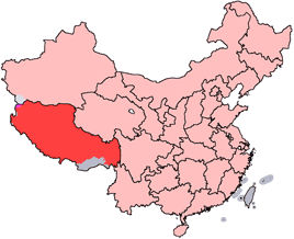
The Tibet Autonomous Region (TAR) comprises seven prefecture-level administrative divisions: six prefecture-level cities—Lhasa, Shigatse (Rikaze), Chamdo (Changdu), Nagqu (Naqu), Nyingchi (Linzhi), and Lhoka (Shannan)—and one prefecture, Ngari (Ali).[9] This structure, established following the region's incorporation into the People's Republic of China in 1951 and formalized as an autonomous region in 1965, organizes governance and populated places hierarchically from provincial to local levels.[10] Lhasa, the capital, functions as both a prefecture-level city and the political, economic, and cultural center, housing approximately 874,000 residents as of 2020.[11] These prefecture-level units are subdivided into 74 county-level divisions, consisting of 67 counties, six districts, and one county-level city, which as of June 2023 encompass the majority of TAR's 3.65 million population.[12] [9] County-level entities further divide into 691 township-level units, including 91 towns, 569 townships, seven ethnic townships, and 24 subdistricts, below which lie approximately 6,086 village committees administering rural settlements.[8] Populated places, ranging from urban districts in Lhasa to remote villages in Ngari Prefecture, are thus cataloged and governed within this framework, reflecting a centralized system prioritizing stability and development in a high-altitude, sparsely populated territory spanning 1.23 million square kilometers.[10] This administrative hierarchy facilitates the distribution of over 90% ethnic Tibetan population across divisions, with urban concentration in eastern prefectures like Chamdo and Nyingchi contrasting sparse western areas such as Ngari, where elevations exceed 4,500 meters and settlements cluster around oases and monasteries.[11] Official delineations exclude Tibetan-inhabited areas in adjacent provinces like Qinghai and Sichuan, confining TAR to historic Ü-Tsang and parts of Kham, a demarcation criticized by exile administrations for fragmenting ethnic cohesion but defended by Chinese authorities as accommodating local autonomy within national sovereignty.[4] [13]Population and Demographic Data
The Tibet Autonomous Region recorded a resident population of 3,648,100 in China's Seventh National Population Census of November 2020, administered by the National Bureau of Statistics.[6] This figure reflects a 9.5% increase from the 2010 census total of 3,002,166, driven primarily by natural growth and internal migration, though the region's population density remains among the lowest globally at approximately 3 persons per square kilometer across its 1.228 million square kilometers of terrain dominated by high plateaus and mountains.[14] [14] Tibetans constituted 86% of the TAR's population in 2020, equating to about 3.14 million individuals, with Han Chinese at 12.2% (roughly 445,000) and other ethnic groups, such as Hui, Monba, and Lhoba, comprising the remaining 1.8%.[15] [16] The Han proportion rose from 8.2% in 2000 and 7.8% in 2010, a trend linked to state-facilitated economic development, infrastructure projects, and incentives attracting laborers from eastern China, though official data from the census—conducted under centralized authority—has faced scrutiny from Tibetan advocacy groups for potential underreporting of native demographic pressures or overemphasis on migrant inflows.[16] Tibetan fertility rates exceed the national average, contributing to sustained ethnic majority status amid overall low population growth elsewhere in China.[15] Demographic distribution is heavily skewed toward rural areas, where over 60% of residents live, engaged mainly in pastoral nomadism, barley cultivation, and yak herding adapted to altitudes exceeding 4,000 meters; urbanization stood at approximately 37% by the early 2020s, the lowest provincial-level rate in China, with urban growth concentrated in administrative hubs amid limited arable land (less than 0.1% of total area).[17] Populated places are sparse and clustered in river valleys of the Yarlung Tsangpo and other basins, with prefecture-level divisions hosting the bulk: Lhasa (867,891), Shigatse (798,153), Chamdo (760,966), Nagqu (504,838), and Nyingchi (474,462) as of 2020.[18]| Prefecture-level Division | Population (2020 Census) |
|---|---|
| Lhasa | 867,891 |
| Shigatse | 798,153 |
| Chamdo | 760,966 |
| Nagqu | 504,838 |
| Nyingchi | 474,462 |
Naming Conventions
Official Pinyin Romanization and Standardization
The People's Republic of China mandates Hanyu Pinyin as the official romanization system for place names in the Tibet Autonomous Region, applying it to Han character transliterations of Tibetan toponyms to ensure uniformity in administrative records, maps, and publications. This policy stems from the 1958 State Council approval of Pinyin as the standard for Chinese phonetic transcription, extended to ethnic regions via decrees promoting national standardization of geographical nomenclature.[20] For Tibetan-specific names, the scheme transliterates local pronunciations into Han characters—such as 拉萨 (Lāsà) for Lhasa—before applying Pinyin, prioritizing phonetic approximation over etymological fidelity to Tibetan script.[21] A dedicated protocol for minority languages, the "Rules for the Chinese Phonetic Alphabet Spelling of Place Names in Minority Nationality Languages" (Shaoshu minzuyu diming Hanyu pinyin zimu yinyi zhuanxiefa), governs direct phonetic rendering of Tibetan sounds using Pinyin's alphabet and conventions, adopted in the late 1970s and refined through the 1980s. This system, often termed "Tibetan Pinyin" or SASM/GNC romanization, transcribes Standard Tibetan (Lhasa dialect) without tones, as in official gazetteers listing prefectures like Rìkāzé for Shigatse or Chámùduǒ for Chamdo.[22][23] The Ministry of Civil Affairs enforces compliance, publishing updates—such as the 2021 TAR-wide standardization affecting over 80 counties—to align with digital mapping and international protocols, following United Nations endorsement of Pinyin in 1979.[24] Implementation has prioritized administrative efficiency over traditional Tibetan orthography, resulting in romanizations that reflect Mandarin-influenced readings of Han forms rather than native Tibetan phonology; for example, Nagqu appears as Nàqū, diverging from Wylie transliteration's Na-ga-chu. Critics, including exile groups, argue this fosters cultural assimilation by embedding Chinese linguistic norms, though official rationales emphasize legibility and anti-chaos measures post-1949 inconsistencies.[25] Standardization extends to coordinates and bilingual listings (Tibetan script, Han characters, Pinyin), as seen in 2025 Ministry releases for border areas, reinforcing claims via cartographic authority.[26][27]Tibetan Transliterations and Historical Names
The transliteration of Tibetan place names into Latin script predominantly utilizes the Wylie system, developed by Turrell V. Wylie in 1959, which maps each character of the Tibetan abugida to corresponding Roman letters without diacritics, prioritizing orthographic fidelity over phonetic accuracy. This approach, adopted by institutions such as the Library of Congress, enables precise representation of Tibetan script for scholarly purposes, including toponyms in the Tibet Autonomous Region (TAR), where names like Lhasa (lha sa, "place of the gods") and Shigatse (gzhis ka rtse, "flour mill peak") illustrate the system's application to administrative centers.[28][29] The Wylie's limitations in capturing Central Tibetan pronunciation—such as aspirated consonants or vowel shifts—have prompted extensions, like the Tibetan and Himalayan Library's variant, which incorporates subjoined letters and simplified phonetics for readability while maintaining core principles.[30] Historical Tibetan names for populated places in the TAR derive from Old Tibetan linguistic roots, often documented in 8th- to 15th-century texts like the Dunhuang manuscripts or the Blue Annals (deb ther sngon po), reflecting pre-modern divisions into provinces such as Ü-Tsang (central TAR heartland, encompassing Lhasa and Shigatse) rather than contemporary prefectures. These names frequently encode geographic, religious, or mythic etymologies; for example, Chamdo (cham mdo, "confluence of rivers") references its location at the Dharma and Mekong rivers' junction, a designation predating 1950s administrative reforms.[31] In contrast to People's Republic of China-mandated Tibetan pinyin (ZWPY), which standardizes romanization for official use and aligns with Mandarin phonology (e.g., Lhasa as 拉萨 in Pinyin but lha sa in Wylie), historical transliterations in exile or Western scholarship preserve indigenous orthography to avoid phonetic approximations influenced by state standardization. This distinction underscores source credibility issues, as PRC-endorsed systems like ZWPY, formalized in the 1980s, prioritize integration into national nomenclature over fidelity to Tibetan dialectal variations across TAR prefectures like Nagqu or Nyingchi.[32]| Place (English Conventional) | Wylie Transliteration | Historical Etymology/Note |
|---|---|---|
| Lhasa | lha sa | "Abode of gods"; central to Ü-Tsang province since 7th century.[33] |
| Shigatse | gzhis ka rtse | Traditional seat of Panchen Lama; from gzhis (foundation) and rtse (peak).[28] |
| Chamdo | cham mdo | Key Kham region town; name evokes river confluences in 11th-century records.[23] |
| Nagqu | nag chu | "Black river"; pastoral hub in northern TAR, referenced in Tibetan geographic treatises.[34] |
Debates on Cultural Implications and Sinicization Claims
The adoption of standardized Pinyin romanizations for Chinese designations of Tibetan place names has fueled debates over whether this practice constitutes a neutral administrative measure or a component of broader Sinicization efforts aimed at assimilating Tibetan cultural elements into Han-dominated frameworks. Chinese government policies, as outlined in standardization initiatives by the Ministry of Civil Affairs, emphasize the use of official Chinese characters, Pinyin transliterations, and parallel Tibetan script for place names to ensure uniformity in governance, mapping, and legal documentation across the multi-ethnic Tibet Autonomous Region (TAR).[36] Proponents, including state-affiliated sources, argue that such naming reflects historical Chinese administrative records dating back centuries and promotes practical integration, citing examples like the rendering of Lhasa as Lāsà (拉萨) alongside its Tibetan form.[37] Critics, particularly from Tibetan exile organizations such as the Central Tibetan Administration and the International Campaign for Tibet, contend that prioritizing Pinyin and Chinese characters in official lists, road signage, and international representations erodes the intrinsic cultural, religious, and historical meanings embedded in Tibetan toponyms, which often derive from Buddhist lore, geography, or clan histories.[38] [26] For instance, road signs in the TAR frequently display Chinese names in larger, more prominent fonts with Tibetan equivalents subordinated, which observers like anthropologist Katia Buffetrille interpret as a subtle mechanism for normalizing Han linguistic dominance and decoupling places from their Tibetan semantic roots.[39] These groups link the practice to wider policies, including Mandarin-centric education reforms since the 2010s, which have reduced Tibetan language instruction and potentially accelerated the loss of native name familiarity among younger generations.[40] Empirical evidence for systematic renaming within core TAR populated places remains sparse, with documented cases more prevalent in disputed border areas like those claimed as "southern Tibet" (e.g., Arunachal Pradesh), where China issued standardized names for 30 locations in April 2024 using Chinese, Tibetan, and Pinyin formats to assert territorial claims.[41] [42] Within the TAR, official gazetteers maintain dual naming, but the push to replace "Tibet" with "Xīzàng" in English-language contexts—evident in 2022 Ministry of Foreign Affairs documents—exemplifies efforts to reframe regional identity linguistically, prompting accusations of nomenclature aggression from advocacy sources.[43] [44] These debates are informed by divergent source perspectives: Chinese state narratives frame standardization as enhancing national cohesion without cultural suppression, supported by data on infrastructure development correlating with name uniformity, while Western and Tibetan advocacy reports, often drawing from defector testimonies and satellite imagery of signage, highlight risks of identity dilution but face scrutiny for selective emphasis amid geopolitical tensions.[45] Independent verification is challenged by restricted access to the TAR, though longitudinal studies of name usage in pre-1950s versus post-reform era maps indicate a shift toward Chinese primacy in administrative contexts, without wholesale erasure of Tibetan oral traditions.[25] Ultimately, causal links between naming policies and measurable cultural loss—such as declining Tibetan-language literacy rates from 90% in 1990 to under 50% in some TAR prefectures by 2020—remain contested, requiring disaggregation from confounding factors like urbanization and migration.[46]Populated Places by Prefecture-Level Division
Lhasa
Lhasa (Chinese: 拉萨市; pinyin: Lāsà Shì) is a prefecture-level municipality serving as the capital of the Tibet Autonomous Region in China. It encompasses an area of 29,680 square kilometers and administers three urban districts and five counties as its primary populated places.[47][48] According to the Seventh National Population Census conducted in 2020, the total resident population of Lhasa municipality stood at 867,891.[49] The administrative divisions include:| Division | Type | Population (2020) | Administrative Seat |
|---|---|---|---|
| Chengguan District (城关区) | District | 473,586 | Lhasa urban area |
| Duilongdeqing District (堆龙德庆区) | District | 91,065 | Duilongdeqing Town |
| Dazi District (达孜区) | District | 32,318 | Dazi Town |
| Linzhou County (林周县) | County | 50,596 | Lhünzhub Town |
| Dangxiong County (当雄县) | County | 47,900 | Dangxiong Town |
| Nimu County (尼木县) | County | 29,989 | Nimu Town |
| Qushui County (曲水县) | County | 41,851 | Qushui Town |
| Mozhugongka County (墨竹工卡县) | County | 49,511 | Mozhugongka Town |
Shigatse
Shigatse Prefecture, officially Rikaze City, constitutes the largest administrative division within the Tibet Autonomous Region, encompassing an area of 182,000 square kilometers and a population of roughly 799,500 inhabitants, predominantly Tibetan.[51] [52] Its populated places are primarily the administrative seats of its county-level subdivisions, consisting of one district and 17 counties, which function as local economic, cultural, and transportation hubs amid high-altitude terrain averaging 3,800 to 4,500 meters elevation.[53] [54] These seats vary from modest towns supporting agriculture, herding, and pilgrimage to border outposts facilitating trade with Nepal and India.[11] The prefecture's key populated places, corresponding to subdivision seats, include:- Samzhubzê District (Shigatse): The prefectural capital and second-largest urban center in Tibet, historically the seat of the Panchen Lama and Tashilhunpo Monastery, serving as a major trade and administrative node.[52]
- Bainang County (Bainang Town): Agricultural focus in the upper Brahmaputra valley.[53]
- Dinggyê County (Dinggyê Town): Rural seat supporting barley and yak herding.[53] [11]
- Gangba County (Gangba Town): Nomadic pastoral area in remote highlands.[11]
- Gyantse County (Gyantse Town): Historic fortress town on trade routes, known for the Pelkor Chode Monastery complex.[53] [11]
- Kangmar County (Kangmar Town): Highland pastoral community.[55]
- Lhatse County (Lhatse Town): Gateway town near the Nepal border route.[52]
- Namling County (Namling Town): Agricultural settlement in southern valleys.[55]
- Nyalam County (Nyalam Town): Border town at 3,800 meters, entry point from Nepal via Zhangmu port.[55]
- Rinbung County (Rinbung Town): Rural hub near Shigatse.[56]
- Sa'gya County (Sa'gya Town): Site of the influential Sakya Monastery, a center of Tibetan Buddhism.[52]
- Saga County (Saga Town): Remote western outpost en route to Mount Everest base camp.[11]
- Tingri County (Tingri Town): High-pass settlement at 4,300 meters, proximity to Everest and key for mountaineering access.[11]
- Xaitongmoin County (Xaitongmoin Town): Pastoral and farming area.[55]
- Yadong County (Yadong Town): Strategic border town adjacent to Sikkim and Bhutan, hosting trade facilities.[11]
- Zhongba County (Zhongba Town): Isolated nomadic region in the far west.[11]
Chamdo
Chamdo City, officially known as Changdu in Pinyin, is a prefecture-level division in the eastern sector of the Tibet Autonomous Region, adjacent to Sichuan and Qinghai provinces. It functions as a key transportation and economic hub, linking central Tibet with inland China via highways such as the G318. The prefecture encompasses one district and ten counties, forming the core administrative units and primary loci of human settlement, with rural townships and villages comprising smaller populated places under these jurisdictions.[57] The county-level divisions, which host the main towns and urban centers, are as follows:- Karuo District: The administrative seat of Chamdo City, centered on Chengguan Town, which recorded a population of 45,861 in the 2010 census and serves as the region's commercial and governmental nucleus. Wait, no wiki, but [web:13] is wiki, oh can't cite wiki. Wait, [web:13] is wiki, skip pop or find other.
- Karuo District (seat: Chengguan)
- Banbar County
- Baxoi County
- Dengqên County
- Dragyab County
- Gonjo County
- Joda County
- Lhorong County
- Markham County
- Riwoche County
- Zogang County
Nagqu
Nagqu City (那曲市), established as a prefecture-level municipality on May 7, 2018, from the former Nagqu Prefecture, spans 450,537 km² in northern Tibet Autonomous Region and had a population of 462,381 as of 2000 census data updated in administrative records.[3][60] The region features high-altitude grasslands supporting nomadic pastoralism, with settlements concentrated in administrative centers amid sparse overall density of about 1 person per km².[14] Its county-level divisions, whose seats constitute the primary populated places, include Seni District and ten counties: Amdo County, Baqên County, Biru County, Jiali County, Nyainrong County, Nyima County, Shuanghu County, Sog County, Xainza County, and Pangkog County.[61] Seni District, formerly Nagqu County, centers on Nagqu Town (also known as Heihe Town historically), the municipal seat at approximately 4,500 meters elevation, serving as a hub for trade, transport, and herding communities.[62] Key county seats as populated places include:- Amdo Town (Amdo County), a small settlement focused on livestock grazing near the Qiangtang Plateau.
- Biru Town (Biru County), administrative center amid remote valleys.
- Lhari Town (Jiali County), located eastward toward Chamdo Prefecture.
- Nyainrong Town (Nyainrong County), supporting local Tibetan herders.
- Nyima Town (Nyima County), in the western expanse bordering Ngari.
- Sog Town (Sog County), a northern outpost near Qinghai.
- Xainza Town (Xainza County), known for high-altitude lakes and pastoral economy.
- Seats of Baqên, Pangkog, and Shuanghu counties, the latter as a special administrative area with dispersed nomadic clusters rather than a single town center.[61]
Nyingchi
Nyingchi Prefecture, situated in the southeastern part of the Tibet Autonomous Region, covers 116,175 square kilometers and had a total population of 238,936 as of the 2020 census, with settlements primarily clustered in river valleys at lower elevations conducive to agriculture and forestry.[64] The prefecture's administrative divisions include one district and six counties, whose seats form the core populated places, reflecting a sparse distribution shaped by rugged terrain and historical trade routes along the Nyang River.[65] These centers support local economies centered on timber, hydropower, and tourism, with Tibetan ethnic groups comprising the majority alongside Monpa and Lhoba minorities.[66] Bayi District, the prefectural seat, centers on Bayi Town (also Bayi), which serves as the urban hub with infrastructure including the Nyingchi Mainling Airport and connections via the Sichuan-Tibet Highway. The district's population stood at 84,254 in 2020, encompassing Bayi Town's core settlement of around 40,000 residents engaged in administration, commerce, and light industry.[67] [68] Other principal populated places include the seats of the counties:- Gongbogyamda Town (in Gongbogyamda County), a historical waypoint on pilgrimage routes, supporting pastoral and farming communities in a valley setting.
- Mainling Town (in Mainling County), with a county population contributing to the prefecture's arable output; the town itself anchors 26,176 residents as of 2020, near the prefecture's airport.[69]
- Bomê Town (in Bomê County), focused on forestry amid high biodiversity areas.
- Mêdog Town (in Mêdog County), recently accessible via road completions in 2013, hosting small-scale settlements in subtropical zones.
- Zayü Town (in Zayü County), bordering Myanmar and India, with populations tied to border trade and ethnic diversity including Lisu groups.
- Nang Town (in Nang County), the smallest unit with 17,648 residents in 2020, emphasizing remote highland herding.[70]
Shannan
Shannan City is a prefecture-level administrative division in southeastern Tibet Autonomous Region, China, encompassing the historical region of Lhoka along the middle Yarlung Tsangpo River valley. It spans 79,700 square kilometers with a population of 320,000 as of 2015, over 96% of whom are ethnic Tibetans. The capital, Tsetang in Nedong District, lies 183 kilometers southeast of Lhasa and serves as a key cultural and economic hub.[72][73] Shannan administers Nedong District and 11 counties, whose seats form the primary populated places. These include:- Tsetang (Nedong District seat)
- Gonggar Town (Gonggar County seat)
- Nakartse (Nakartse County seat, approximate based on administrative mappings)
- Sangri (Sangri County seat)
- Qonggyai (Qonggyai County seat)
- Comai (Comai County seat)
- Lhozhag (Lhozhag County seat)
- Cona (Cona County seat)
- Lhünzê (Lhünzê County seat)
- Nagarzê (Nagarzê County seat)
- Zhanang (Zhanang County seat)
- Gyaca (Gyaca County seat)
Ngari
Ngari Prefecture, situated in the northwestern extremity of the Tibet Autonomous Region, spans approximately 337,175 square kilometers and had a population of 123,281 as of recent records, yielding one of the lowest population densities globally at about 0.37 people per square kilometer due to its high-altitude desert terrain and extreme climate.[76] The prefecture administers seven counties—Gar, Burang, Zanda, Rutog, Gê'gyai, Gêrzê, and Coqên—encompassing 106 townships and 359 villages as the primary populated places, with urban centers limited to county seats and sparse rural settlements predominantly inhabited by Tibetan herders and farmers.[77] Shiquanhe Town, the prefectural administrative center in Gar County, serves as the largest settlement, with a recorded population of 10,507 in the 2010 census. The main populated places are concentrated in county-level towns:- Gar County: Seat at Shiquanhe Town (elevation 4,200 meters), population approximately 31,052 county-wide as of 2020; supports political and economic functions for the prefecture.[78]
- Burang County: Seat at Purang Town (near Nepal border), focused on cross-border trade and pilgrimage routes; county population data limited but contributes to regional herding economy.
- Zanda County: Seat at Zanda Town, near ancient cliffside ruins; sparse settlements adapted to arid valleys.
- Rutog County: Seat at Rutog Town, along the Xinjiang-Tibet Highway; includes mining outposts and nomadic encampments.
- Gê'gyai County: Seat at Gê'gyai Town; rural townships centered on pastoralism in high plateau.
- Gêrzê County: Seat at Gêrzê Town; minimal urban development amid salt lake basins.
- Coqên County: Seat at Coqên Town; villages sustain livestock grazing in remote grasslands.
Additional Classifications
By Population Size
The seven prefecture-level divisions of the Tibet Autonomous Region, which encompass its primary populated places including cities, towns, and rural settlements, vary significantly in population due to geographic and climatic factors. According to China's Seventh National Population Census conducted in 2020, the total resident population of the region was 3,648,100, with distributions reflecting denser settlement in southern and eastern areas compared to the sparsely populated northern and western highlands.[6] These figures represent permanent residents and include both urban and rural inhabitants, as reported by the National Bureau of Statistics.| Rank | Prefecture | Population (2020 Census) |
|---|---|---|
| 1 | Lhasa | 867,891 |
| 2 | Shigatse | 798,153 |
| 3 | Chamdo | 760,966 |
| 4 | Nagqu | 504,838 |
| 5 | Shannan | 354,035 |
| 6 | Nyingchi | 238,936 |
| 7 | Ngari | 123,281 |
By Elevation and Geography
The populated places of the Tibet Autonomous Region are predominantly adapted to the Tibetan Plateau's extreme topography, with settlements concentrated in river valleys, basins, and high grasslands where water access and pastoral or limited agricultural activity are feasible. Elevations range from approximately 2,700 meters in southeastern border areas to over 4,800 meters in northern and western interiors, influencing population density, architecture, and livelihoods—lower areas support denser farming communities, while higher zones rely on nomadic herding amid sparse oxygen and harsh climates.[81] [82] The region's geography divides broadly into eastern forested valleys with subtropical influences, central highland basins flanked by the Himalayas, and northwestern arid plateaus, shaping settlement patterns to avoid sheer peaks and maximize habitable micro-environments.[83] Classifications by elevation reveal a gradient from moderate southeastern lowlands to extreme high-altitude interiors:- Low elevation (below 3,500 m): These settlements, mainly in Nyingchi Prefecture's Yarlung Tsangpo valleys, feature milder temperatures, denser forests, and higher precipitation, enabling terraced farming and permanent villages; examples include Pomi at 2,750 m and Nyingchi Town at 3,100 m.[82] [83]
- Moderate elevation (3,500–4,000 m): Central riverine settlements in Lhasa, Shannan, and Chamdo prefectures occupy fertile alluvial plains and gorges, supporting urban centers with monasteries and markets; Lhasa at 3,650 m lies in the Lhasa River valley, Shigatse at 3,800–3,840 m at the Nyang Chu confluence, Tsedang at 3,500–3,580 m near ancient palace sites, and Chamdo at 3,200 m amid eastern canyon lakes.[82] [83]
- High elevation (above 4,000 m): Interior plateau and Himalayan foothill towns in Nagqu, Ngari, and Shigatse emphasize pastoral nomadism on vast grasslands or near sacred lakes, with sparser populations due to altitude sickness risks and permafrost; Nagqu Town at 4,500–4,507 m anchors northern grasslands near Namtso Lake, Shiquanhe in Ngari at 4,280 m borders arid western deserts by Mount Kailash, Gyantse at 3,977–4,000 m overlooks Nyang Chu Valley forts, Tingri at 4,300 m serves Everest approaches, Damxung at 4,200 m flanks hot springs, and Amdo at 4,800 m exemplifies remote northern highs.[82] [83]
| Place | Prefecture | Elevation (m) | Key Geographical Features |
|---|---|---|---|
| Lhasa | Lhasa | 3,650 | Central river valley basin, alluvial plains[82] |
| Shigatse | Shigatse | 3,800–3,840 | River confluences, Himalayan foothills[83] |
| Nagqu Town | Nagqu | 4,500–4,507 | High-altitude grasslands, lake proximity[82] |
| Nyingchi Town | Nyingchi | 3,000–3,100 | Southeastern forested grand canyon valleys[83] |
| Shiquanhe | Ngari | 4,280 | Northwestern arid plateau, desert fringes[82] |
| Chamdo Town | Chamdo | 3,200 | Eastern highland gorges, canyon lakes[83] |
References
- https://en.wikivoyage.org/wiki/Nyingchi