

Community hub
Recent from talks
Contribute something
Nothing was collected or created yet.
Short Pump, Virginia
View on Wikipedia
Short Pump is a census-designated place (CDP) in Henrico County, Virginia, United States. It is a borough of Richmond. The population was 30,626 at the 2020 census.[3]
Key Information


The original village of Short Pump was located at the intersection of Three Chopt Road (formerly known as Three Notched Trail), Richmond Turnpike and Pouncey Tract Road. The area first centered around a local tavern that was expanded by Col. Robert H. Saunders beginning in 1814. According to local legend, it was named for the short handled water pump for stagecoach horses to drink from, which was located beneath the porch of the tavern, though there is some debate over the name's origin.[4] This area was on the principal route between Richmond and Charlottesville, as well as other towns in the Blue Ridge Mountains. Thomas Jefferson,[5] the Earl Cornwallis, the Marquis de Lafayette, General Peter Muhlenberg, Stonewall Jackson and Ulric Dahlgren all visited this area.
The crossroads was officially named Short Pump by 1853, according to a Henrico County map found in the Virginia Historical Society.[5]
It has now become part of Richmond's Far West End. In 2003, developers opened Short Pump Town Center, a 1,200,000-square-foot (110,000 m2) open air shopping mall. Other shopping and living spaces include West Broad Village.[6]
Short Pump is noted for its shopping centers, restaurants, skating rink, and bowling alley. The area is an edge city of Richmond.[4]
History
[edit]Short Pump began as a local tavern stop situated at a strategic crossroads in the early nineteenth century. Purchased around 1814 by Col. Saunders, the tavern profited from the local coal industry, westward movement in the state, and the extension of roads in the period after the Revolutionary War. Along with the food, drink, and lodgings that taverns typically provided for visitors, this tavern served as a post-office, voting precinct, and local market during its roughly 35 years in business. It also briefly housed a school for young white men and a resident doctor. While a gathering spot for white locals and travelers, the tavern relied on enslaved labor and hosted occasional slave auctions.[4]
The tavern eventually declined in the latter half of the nineteenth century, but the name stuck to the area. By the early twentieth century, the tavern was all but gone, and other buildings and businesses rose up to take its place. As automobiles replaced horses as the primary means of transportation, filling stations and garages popped up in the area. At the same time, those living in Short Pump increasingly saw themselves as a suburb of Richmond and worked to better their community through the building of new structures—like the Short Pump High School.[4][7]
By the 1990s and 2000s, Short Pump transformed from a rural crossroads to an edge-city, a concentration of development on the outskirts of traditional urban areas. The Short Pump Town Center, a mega-mall, proved key to this transformation.
Geography
[edit]According to the United States Census Bureau, the CDP has a total area of 9.1 square miles (23.5 km2), of which 9.0 square miles (23.2 km2) is land and 0.12 square miles (0.3 km2), or 1.33%, is water.[8] Short Pump is bordered to the west by Goochland County, to the north by the Wyndham CDP, to the east by the Innsbrook CDP, and to the south by non-CDP land and by Tuckahoe.[8]
Climate
[edit]| Climate data for Short Pump, Virginia (1980-2010) | |||||||||||||
|---|---|---|---|---|---|---|---|---|---|---|---|---|---|
| Month | Jan | Feb | Mar | Apr | May | Jun | Jul | Aug | Sep | Oct | Nov | Dec | Year |
| Mean daily maximum °F (°C) | 46.6 (8.1) |
50.7 (10.4) |
59.3 (15.2) |
70 (21) |
77.2 (25.1) |
84.9 (29.4) |
88.3 (31.3) |
86.9 (30.5) |
80.6 (27.0) |
70.3 (21.3) |
60.3 (15.7) |
49.5 (9.7) |
68.7 (20.4) |
| Mean daily minimum °F (°C) | 24.8 (−4.0) |
26.9 (−2.8) |
33.1 (0.6) |
42.3 (5.7) |
51.2 (10.7) |
60.7 (15.9) |
65.1 (18.4) |
63.9 (17.7) |
56.2 (13.4) |
44.5 (6.9) |
35.4 (1.9) |
27.6 (−2.4) |
44.3 (6.8) |
| Average precipitation inches (mm) | 3.1 (79) |
2.9 (74) |
3.8 (97) |
3.3 (84) |
3.9 (99) |
3.5 (89) |
4.4 (110) |
4.0 (100) |
3.7 (94) |
3.3 (84) |
3.7 (94) |
3.3 (84) |
42.9 (1,088) |
| Source: USA.com[9] | |||||||||||||
Demographics
[edit]| Census | Pop. | Note | %± |
|---|---|---|---|
| 2010 | 24,729 | — | |
| U.S. Decennial Census[10] 2000[11] 2010[12] 2020 | |||
Short Pump was first listed as a census designated place in the 2000 U.S. census.[11]
At the 2010 census,[1] there were 24,729 people, 9,217 households and 6,483 families residing in the CDP. The population density was 76.7 people per square mile (29.6 people/km2). There were 77 housing units at an average density of 32.5 units per square mile (12.5 units/km2). The racial makeup of the CDP was 75.0% White, 5.70% African-American, 15.9% Asian, and 3.2% Hispanic or Latino.
There were 9,217 households, of which 31.9% had children under the age of 18 living with them, 60.3% were married couples living together, 10.1% had a female householder with no husband present, and 36.2% were non-families. 26.1% of all households were made up of individuals, and 8.7% had someone living alone who was 65 years of age or older. The average household size was 2.64 and the average family size was 3.30.
26.9% of the population were under the age of 18, 6.0% from 18 to 24, 33.5% from 25 to 44, 18.1% from 45 to 64, and 15.4% who were 65 years of age or older.
The median household income was $105,300 and the median family income was $117,995. The per capita income for the CDP was $46,047. 4.1% of the population lived below the poverty line.
Education
[edit]Elementary schools
[edit]- Colonial Trail Elementary School
- Rivers Edge Elementary School
- Gayton Elementary School
- Nuckols Farm Elementary School
- Short Pump Elementary School
- Twin Hickory Elementary School
- David A. Kaechele Elementary School
Middle
[edit]- Holman Middle School
- Pocahontas Middle School
- Short Pump Middle School
High
[edit]Boundaries of Short Pump
[edit]The boundaries of the Short Pump CDP start on the west at the Goochland County/Henrico County line, then proceed east on Kain Road to Pouncey Tract Road (Virginia State Route 271); north on Pouncey Tract Road to Shady Grove Road; east, then north, on Shady Grove Road to Nuckols Road; southeast and south on Nuckols Road to Interstate 295; southwest on I-295 to Interstate 64; southeast on I-64 to Cox Road; southwest on Cox Road to Three Chopt Road where Cox Road becomes Church Road; southwest, then west, on Church Road to Lauderdale Drive; southwest on Lauderdale Drive to Causeway Drive; northwest on Causeway Drive to its crossing of Wilde Lake; southwest through the center of Wilde Lake to its outlet, Harding Branch; westward down Harding Branch to its outlet at Tuckahoe Creek, which is the Goochland/Henrico County line; then north on the county line back to Kain Road.[8]
References
[edit]- ^ a b "U.S. Census website". United States Census Bureau. Retrieved January 31, 2008.
- ^ "US Board on Geographic Names". United States Geological Survey. October 25, 2007. Retrieved January 31, 2008.
- ^ "Profile of General Population and Housing Characteristics: 2020 Demographic Profile Data (DP-1): Short Pump CDP, Virginia". United States Census Bureau. Retrieved May 4, 2023.
- ^ a b c d Tharp, William R. (2022). "Roads, Race, and Retail: The Transformation of Short Pump, Virginia". Buildings & Landscapes: Journal of the Vernacular Architecture Forum. 29 (2): 74–98. doi:10.1353/bdl.2022.0014. S2CID 252908720. Project MUSE 867166.
- ^ a b Dickerson, Trevor (June 17, 2009). "It Truly Was a Short Pump". Richmond Times Dispatch. Retrieved March 25, 2015.
- ^ Lappas, Tom (February 2, 2011). "Mall Helped Solidify Short Pump's Status". Henrico Citizen. Retrieved March 25, 2015.
- ^ A History of Short Pump School, by Hugh Douglas Pitts, 1987
- ^ a b c "Geographic Identifiers: 2010 Demographic Profile Data (G001): Short Pump CDP, Virginia". United States Census Bureau. Retrieved August 6, 2012.
- ^ "Climatological Information for Short Pump, Virginia", USA.com, 2003. Web: [1].
- ^ "Decennial Census by Decade". United States Census Bureau.
- ^ a b "2000 Census of Population - Population and Housing Unit Counts - Virginia" (PDF). United States Census Bureau.
- ^ "2010 Census of Population - Population and Housing Unit Counts - Virginia" (PDF). United States Census Bureau.
- ^ U.S. Census Bureau (2014-2018). People Reporting Ancestry American Community Survey 5-year estimates. Retrieved from <https://censusreporter.org>
- ^ U.S. Census Bureau (2014-2018). Asian Alone by Selected Groups American Community Survey 5-year estimates. Retrieved from <https://censusreporter.org>
- ^ U.S. Census Bureau (2014-2018). Hispanic or Latino Origin by Specific Origin American Community Survey 5-year estimates. Retrieved from <https://censusreporter.org>
External links
[edit]- www.henricohistoricalsociety.org — Short Pump Lost Architecture (2015). Henrico County Historical Society
- Tharp, William R. (2022). "Roads, Race, and Retail: The Transformation of Short Pump, Virginia". Buildings & Landscapes: Journal of the Vernacular Architecture Forum. 29 (2): 74–98. doi:10.1353/bdl.2022.0014. S2CID 252908720. Project MUSE 867166.
Municipalities and communities of Henrico County, Virginia, United States | ||
|---|---|---|
| CDPs | 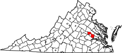 | |
| Unincorporated communities | ||
Short Pump, Virginia
View on GrokipediaHistory
Origins and Early Settlement
The area that became known as Short Pump developed in the early 19th century as a rural crossroads in western Henrico County, Virginia, at the intersection of the Three Chopt Road, the Richmond Turnpike (present-day U.S. Route 250), and Pouncey Tract Road. This location served as a vital stopover for travelers heading west from Richmond, with a tavern functioning as a stagecoach inn where horses could rest and drink from a distinctive short-handled water pump positioned under the building's porch.[2][1] The pump's shorter handle, compared to standard designs, accommodated easier access for horses, and local accounts hold that this feature gave the site its enduring name, with phrases like "meet me at Short Pump" entering common usage among stagecoach patrons.[9] The tavern, operational by at least the early 1800s and possibly established around 1815, marked the nucleus of initial settlement, drawing farmers, merchants, and transients to the fertile Piedmont landscape. Surrounding properties were granted to early landowners during the colonial period, but substantive community formation awaited the turnpike era, which boosted traffic and economic activity at the junction. Records indicate the tavern's role in provisioning travelers, underscoring Short Pump's early reliance on agriculture and transit rather than industry.[2][10] By the mid-19th century, the crossroads had coalesced into a modest village supporting local agrarian life, with the pump and tavern as central landmarks. Early residents included families engaged in tobacco and dairy farming on expansive tracts, reflecting Henrico's broader pattern of post-Revolutionary land distribution to veterans and speculators. No major conflicts or events uniquely defined the settlement's founding, but its strategic position ensured steady, if sparse, growth amid Virginia's rural interior.[11][12]Transition to Suburban Development
The construction of Interstate 64 between 1966 and 1968 enhanced connectivity to central Richmond, laying groundwork for future expansion, though Short Pump remained predominantly agricultural and sparsely populated into the late 20th century.[2] Initial suburban development emerged in the 1980s and 1990s, driven by road widenings along West Broad Street and the conversion of farmland into office parks and housing subdivisions, reflecting broader metropolitan spillover from Richmond.[13] [14] Large-scale transformation accelerated in the late 1990s and early 2000s, as developers pursued mixed-use projects amid rising demand for retail and residential space on the urban fringe. The September 4, 2003, opening of Short Pump Town Center—a 1.2 million square foot open-air mall developed by Forest City Enterprises—marked a pivotal shift, drawing major anchors like Nordstrom and Belk, and spurring ancillary commercial and housing growth.[15] This retail anchor, combined with proximity to interstate access, converted former fields into an edge city characterized by high-traffic corridors and suburban amenities.[16] By the mid-2000s, the influx of chain stores, multiplex cinemas, and planned communities had solidified Short Pump's status as a commercial powerhouse, with daily vehicle traffic on key roads peaking at 69,000 by 2006 before stabilizing post-recession.[14] Factors such as white flight from urban Richmond and targeted retail strategies contributed to this evolution, prioritizing low-density suburban form over dense urban infill.[16]Geography
Location and Boundaries
Short Pump is an unincorporated census-designated place (CDP) located in Henrico County, Virginia, in the northwestern portion of the county. It serves as a suburban community approximately 12 miles west-northwest of downtown Richmond, positioned within the broader West End region of the Richmond metropolitan area. The area's central point lies at the intersection of West Broad Street (U.S. Route 250) and Pouncey Tract Road, with approximate geographic coordinates of 37.6516° N latitude and 77.6121° W longitude.[1][17] As defined by the U.S. Census Bureau for statistical purposes, the Short Pump CDP encompasses a land area of 8.95 square miles and a water area of 0.12 square miles, reflecting its primarily terrestrial extent with minimal aquatic features. These boundaries are not legally binding municipal limits but delineate the populated area for census enumeration and data collection, primarily along major roadways including U.S. Route 250 to the south and Interstate 64 to the north. The CDP borders adjacent communities such as Glen Allen to the north and Tuckahoe to the southeast, integrating into Henrico County's overall layout, which is bounded by the Chickahominy River to the north and the James River to the south.[18][19] Associated ZIP codes for the area include 23059, 23060, 23233, and 23238, which overlap with the CDP's extent and facilitate postal and service delineation, though they extend slightly beyond the strict census boundaries.[20]Physical Features and Climate
Short Pump occupies the Piedmont physiographic province of central Virginia, characterized by gently rolling hills and upland terrain that gradually descends eastward toward the Fall Line and James River valley.[21] The area's topography features moderate slopes, with steep gradients exceeding 15% confined primarily to stream valleys and limited portions of the western county; Short Pump itself lies on relatively level to undulating ground suitable for suburban expansion.[22] Elevations average approximately 280 feet (85 meters) above sea level, supporting a landscape historically dominated by deciduous forests and agricultural fields now interspersed with developed woodlands.[23] The region experiences a humid subtropical climate (Köppen classification Cfa), marked by four distinct seasons, high humidity year-round, and no prolonged dry periods. Summers are hot and oppressive, with average July highs reaching 89°F (32°C) and lows around 70°F (21°C), while winters are short and mild, featuring January averages of 49°F (9°C) daytime highs and 29°F (-2°C) overnight lows; extremes rarely dip below 15°F (-9°C) or exceed 96°F (36°C).[24] Annual precipitation totals approximately 44 inches (112 cm), evenly distributed with peaks in summer thunderstorms and occasional winter fronts, contributing to lush vegetation but also risks of localized flooding in low-lying areas.[24]Demographics
Population Trends and Composition
The population of Short Pump experienced substantial growth from 2010 to 2020, expanding from 24,729 residents in the 2010 decennial census to 30,626 in the 2020 decennial census, a 23.8% increase attributable to ongoing suburban expansion and proximity to Richmond's employment centers.[25][5] Recent American Community Survey (ACS) estimates indicate a slight decline, with the population at 28,177 in the 2023 5-year ACS, reflecting possible adjustments in census-designated place boundaries or post-pandemic migration patterns amid broader regional stabilization.[26] This overall upward trend since the early 2000s underscores Short Pump's transformation from a rural crossroads to an affluent commuter enclave, with annual growth rates exceeding state averages during peak development years.[27] Demographically, Short Pump's composition as of the 2019-2023 ACS features a majority non-Hispanic White population at 58.1%, followed by Asian residents at 26.2%—a notably high share linked to professional inflows in technology and healthcare sectors—and Black or African American at 7.5%. Hispanic or Latino individuals of any race comprise about 4.2%, with the remainder including multiracial, Native American, and other groups.[28][26] The area skews toward working-age adults, with a median age of 38.5 years and approximately 52.5% female residents. Foreign-born individuals account for 25.2% of the population, predominantly from Asia, contributing to a diverse yet high-income profile.[6][26]Economy
Commercial Growth and Key Industries
Short Pump's commercial landscape has expanded significantly since the early 2000s, driven by major retail and mixed-use developments that have established it as a suburban economic hub in Henrico County. The opening of Short Pump Town Center on September 9, 2003, represented a $360 million investment in a 147-acre open-air complex with 1.3 million square feet of retail space, anchoring the area's transformation from rural crossroads to a destination for shopping and dining.[29] [30] This project spurred subsequent growth, including additional centers like West Broad Village and Downtown Short Pump, contributing to a proliferation of chain retailers, restaurants, and entertainment options that draw regional consumers.[31] Key industries in Short Pump encompass retail trade alongside professional, scientific, and technical services, which employed the largest share of the area's approximately 15,400 workers in 2023.[26] Finance and insurance, as well as health care and social assistance, also figure prominently, reflecting a mix of office-based employment and service-oriented businesses supported by the community's affluent demographics and proximity to Richmond.[26] Major employers in the broader Henrico context, such as insurance firms like Markel, align with Short Pump's professional services dominance, though retail remains visually emblematic through hubs like Short Pump Town Center.[32] Recent transactions highlight sustained momentum, including the January 2025 sale of the grocery-anchored Short Pump Station shopping center to Nuveen Real Estate, signaling investor confidence in the submarket's dynamic expansion.[33] Mixed-use projects, such as The Corner at Short Pump—a 25-acre development with over 200,000 square feet of retail and restaurant space—illustrate diversification into integrated commercial-residential formats, fostering long-term economic resilience amid evolving consumer preferences.[34]Retail and Business Hubs
Short Pump's retail landscape is dominated by the Short Pump Town Center, an open-air lifestyle center that opened on September 4, 2003, spanning over 1.2 million square feet across 147 acres.[15][35] The facility houses more than 110 retailers, restaurants, and entertainment venues, including anchors like Crate & Barrel, Apple, and Perry's Steakhouse & Grille.[35] Renovated in 2015, it remains a premier shopping destination in the Richmond area, drawing millions of visitors annually due to its upscale offerings and proximity to Interstate 64.[35][36] Complementing the Town Center, West Broad Village serves as a mixed-use retail and business hub on 115 acres, featuring grocery-anchored shopping with tenants such as restaurants and specialty stores alongside residential and office components.[37][38] In 2025, developers proposed adding three 1,500-square-foot retail storefronts and a 2,500-square-foot restaurant space to expand its commercial footprint.[39] Nearby projects like Towne Center West further integrate retail with the Town Center, enhancing the area's 1.3 million square feet of adjacent shopping space.[40] Business activity centers on office developments and coworking facilities, with Westgate 1 emerging as a new corporate headquarters site in 2025.[41] Gather Workspaces provides flexible private offices, team suites, and conference rooms tailored for professional services, benefiting from Short Pump's strategic location and amenities.[42] This blend of retail and office growth has solidified Short Pump as a commercial epicenter, transitioning from rural origins to a high-density economic node supported by robust infrastructure.[36]Education
Public Schools and Performance
Short Pump is served by the Henrico County Public Schools district, which operates several facilities in and around the community. Elementary education is provided primarily by Short Pump Elementary School, located at 3425 Pump Road with an enrollment of 558 students in grades PK-5, and the nearby Rivers Edge Elementary School at 11600 Holman Ridge Road in Glen Allen, serving 725 students in grades PK-5.[43][44][45] Middle school students attend Short Pump Middle School at 4701 Pouncey Tract Road in Glen Allen, with 1,056 students in grades 6-8. High school education is handled by Deep Run High School, which draws from the area and emphasizes advanced academics.[46][47][48] These schools demonstrate strong performance relative to state and district benchmarks, as measured by Virginia Standards of Learning (SOL) assessments and other metrics from the Virginia Department of Education. Short Pump Elementary ranks 87th among Virginia's elementary schools, with student proficiency levels exceeding district averages in reading and mathematics according to School Quality Profiles data.[43][49] Independent evaluations assign it a 4- to 5-star rating, reflecting consistent high achievement across grade levels.[50] Deep Run High School ranks 531st nationally, with 95% of students proficient in reading/language arts and 70-79% in mathematics on SOL tests; it outperforms Henrico County averages and holds a 4- to 5-star rating.[48][51][52] Short Pump Middle and Rivers Edge Elementary also maintain above-average outcomes, with the former showing solid progress in state achievement indicators.[46][53]| School | Grades | Enrollment (approx.) | Key Performance Notes |
|---|---|---|---|
| Short Pump Elementary | PK-5 | 558 | Ranked #87 in VA; strong SOL proficiency per VDOE profiles.[43][49] |
| Rivers Edge Elementary | PK-5 | 725 | Above-average ratings; benefits from local demographics.[44][53] |
| Short Pump Middle | 6-8 | 1,056 | Competent in state metrics; part of accredited cluster.[46] |
| Deep Run High | 9-12 | N/A | National rank #531; 95% reading proficiency, 4-5 stars.[48][52] |