Hubbry Logo
Heading (navigation)Heading (navigation)Main
Open search
Heading (navigation)
Community hub
Heading (navigation)
logo
8 pages, 0 posts
0 subscribers
Be the first to start a discussion here.
Heading (navigation)
from Wikipedia
This wind triangle shows a jet airliner's heading towards point B (HDG, in black; TAS=True Air Speed) and its course towards C (TR, track, in blue; GS=Ground Speed). The drift angle (shaded red) is due to the wind velocity (W/V, in green).

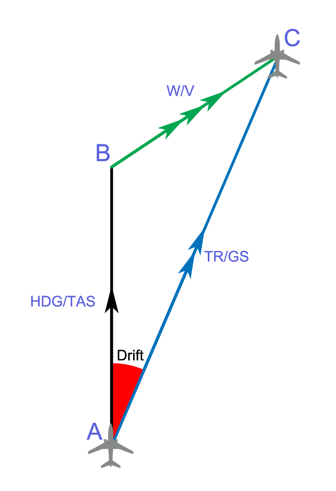
In navigation, the heading of a vessel or aircraft is the compass direction in which the craft's bow or nose is pointed. Note that the heading may not necessarily be the direction that the vehicle actually travels, which is known as its course.[a] Any difference between the heading and course is due to the motion of the underlying medium, the air or water, or other effects like skidding or slipping. The difference is known as the drift, and can be determined by the wind triangle. At least seven ways to measure the heading of a vehicle have been described.[1] Heading is typically based on cardinal directions, so 0° (or 360°) indicates a direction toward true north, 90° true east, 180° true south, and 270° true west.[1]

TVMDC

[edit]
Heading and track (A to B)
1 - True North
2 - Heading, the direction the vessel is "pointing towards"
3 - Magnetic north, which differs from true north by the magnetic variation.
4 - Compass north, including a two-part error; the magnetic variation (6) and the ship's own magnetic field (5)
5 - Magnetic deviation, caused by vessel's magnetic field.
6 - Magnetic variation, caused by variations in Earth's magnetic field.
7 - Compass heading or compass course, before correction for magnetic deviation or magnetic variation.
8 - Magnetic heading, the compass heading corrected for magnetic deviation but not magnetic variation; thus, the heading reliative to magnetic north.
9, 10 - Effects of crosswind and tidal current, causing the vessel's track to differ from its heading.
A, B - Vessel's track.

TVMDC,AW is a mnemonic for converting from true heading, to magnetic and compass headings. TVMDC is a mnemonic initialism for true heading, variation, magnetic heading, deviation, compass heading, add westerly. The most common use of the TVMDC method is deriving compass courses during nautical navigation from maps. The inverse correction from compass heading to true heading is "CDMVTAE", with compass heading, deviation, magnetic heading, variation, true heading, add easterly The most common use of the CDMVTAE rule is to convert compass headings to map headings.

Background

[edit]

The Geographic North Pole around which the Earth rotates is not in exactly the same position as the Magnetic North Pole. From any position on the globe, a direction can be determined to either the Geographic North Pole or to the Magnetic North Pole. These directions are expressed in degrees from 0–360°, and also fractions of a degree. The differences between these two directions at any point on the globe is magnetic variation (also known as magnetic declination, but for the purposes of the mnemonic, the term 'variation' is preferred). When a compass is installed in a vehicle or vessel, local anomalies of the vessel can introduce error into the direction that the compass points. The difference between the local Magnetic North and the direction that the compass indicates as north is known as magnetic deviation.

Determine variation in North America

[edit]

Magnetic variation (also known as magnetic declination) is different depending on the geographic position on the globe. The Magnetic North Pole is currently in Northern Canada and is moving generally south. A straight line can be drawn from the Geographic North Pole, down to the Magnetic North Pole and then continued straight down to the equator. This line is known as the agonic line, and the line is also moving. In the year 1900, the agonic line passed roughly through Detroit and then was east of Florida. It currently passes roughly west of Chicago, IL, and through New Orleans, LA. If a navigator is located on the agonic line, then variation is zero: the Magnetic North Pole and the Geographic North Pole appear to be directly in line with each other. If a navigator is east of the agonic line, then the variation is westward; magnetic north appears slightly west of the Geographic North Pole. If a navigator is west of the agonic line, then the variation is eastward; the Magnetic North Pole appears to the east of the Geographic North Pole. The farther the navigator is from the agonic line, the greater the variation. The local magnetic variation is indicated on NOAA nautical charts at the center of the compass rose. The magnetic variation is indicated along with the year of that variation. The annual increase or decrease of the variation is also usually indicated, so that the variation for the current year can be calculated.

Determine deviation

[edit]

A compass installed in a vehicle or vessel has a certain amount of error caused by the magnetic properties of the vessel. This error is known as compass deviation. The magnitude of the compass deviation varies greatly depending upon the local anomalies created by the vessel. A fiberglass recreational vessel will generally have much less compass deviation than a steel-hulled vessel. Electrical wires carrying current have a small magnetic field around them and can cause deviation. Any type of magnet, such as found in a speaker can also cause large magnitudes of compass deviation. The error can be corrected using a deviation table. Deviation tables are very difficult to create. Once a deviation table is established, it is only good for that particular vessel, with that particular configuration. If electrical wires are moved or anything else magnetic (speakers, electric motors, etc.) are moved, the deviation table will change. All deviations in the deviation table are indicated west or east. If the compass is pointing west of the Magnetic North Pole, then the deviation is westward. If the compass is pointing east of the Magnetic North Pole, then the deviation is eastward.

Formula

[edit]

Calculating TVMDC is done with simple arithmetic. First arrange the values vertically:

  • True
  • Variation
  • Magnetic
  • Deviation
  • Compass

The formula is always added moving down, and subtracted when moving up. The most complicated part is determining if the values are positive or negative. The True, Magnetic, and Compass values are directions on the compass, they must always be a positive number between 0–360. Variation and Deviation can be positive or negative. If either Variation or Deviation is westward, then the values are entered into the equation as positive. If the Variation or Deviation is eastward, then the values are entered into the formula as a negative. Some use the mnemonic: True Virgins Make Dull Companions - Going downward Add Whiskey (or West). An alternative, working the opposite direction: Can Dead Men Vote Twice.

Examples

[edit]

True course is 120°, the Variation is 5° West, and the Deviation is 1° West.

  • T: 120°
  • V: +5°
  • M: 125°
  • D: +1°
  • C: 126°

Therefore, to achieve a true course of 120°, one should follow a compass heading of 126°.

True course is 120°, the Variation is 5° East and the Deviation is 1° East.

  • T: 120°
  • V: −5°
  • M: 115°
  • D: −1°
  • C: 114°

True course is 035°, the Variation is 4° West and the Deviation is 1° East.

  • T: 035°
  • V: +4°
  • M: 039°
  • D: −1°
  • C: 038°

True course is 306°, the Variation is 4° East and the Deviation is 11° West.

  • T: 306°
  • V: −4°
  • M: 302°
  • D: +11°
  • C: 313°

Reverse

[edit]

The formula can also be calculated in reverse. The formula is subtracted when moving up.

Compass course is 093°, the Deviation is 4° West and the Variation is 3° West.

  • T: 086°
  • V: -3°
  • M: 089°
  • D: -4°
  • C: 093°

Thus, when following a compass course of 093°, the true course is 086°.

CDMVT

[edit]

Aviation: CDMVT Can Dead Man Vote Twice: Mnemonic. Easy way to calculate compass magnetic or true north is maintaining the original signs for variation and deviation (+ for east and -for west): C+(Var)= M+(Dev)= T / T-(Dev)= M-(Var)= C

See also

[edit]

Note

[edit]
  1. ^ Nor its track, which is the path that the vessel traces.

References

[edit]

Bibliography

[edit]
Revisions and contributorsEdit on WikipediaRead on Wikipedia
from Grokipedia
In navigation, heading is the compass direction in which the forward part of a vehicle—such as the bow of a ship or the nose of an —is pointed, measured in degrees clockwise from a reference direction, typically (0°) or magnetic north, ranging from 0° to 360°. This orientation differs from the actual path traveled over the ground, as heading indicates the vehicle's immediate directional alignment rather than its . Heading is a fundamental concept in both and maritime contexts, where it serves as the basis for steering adjustments to account for external factors like or currents. In , heading is critical for pilots to maintain control and follow intended routes, often distinguished as true heading (relative to ) or magnetic heading (relative to magnetic north, adjusted for local magnetic variation). True heading is calculated by applying a wind correction to the desired true course, ensuring the aircraft's track—the actual path over the ground—aligns with the planned route despite crosswinds. For instance, if wind pushes the aircraft off course, pilots adjust heading by crabbing into the wind, using a where a crosswind component of about 10% of the requires approximately a 6° correction . Instruments like the , a gyroscopic device displaying in 360° increments, provide real-time heading information, though it requires periodic alignment with the magnetic to correct for errors. In maritime navigation, heading similarly denotes the direction a vessel points, expressed relative to true, magnetic, or north, and is influenced by factors such as waves, , and steering inaccuracies. Unlike course, which is the intended direction of over the or ground, heading may deviate due to or yaw, requiring helmsmen to monitor it via gyrocompasses or GPS-integrated systems for precise maneuvering. Bearing, by contrast, refers to the angular direction from the vessel to a specific point, such as a , and is used alongside heading for plotting routes on nautical charts. Modern systems, including inertial measurement units () and dual-antenna GNSS, enhance heading accuracy at low speeds, supporting applications from commercial shipping to hydrographic surveys. Heading plays a pivotal role in safety and efficiency across navigation domains, as deviations can lead to errors in positioning or collision risks, underscoring the need for regular corrections using tools like the for magnetic references. In both and marine operations, integrating heading with global navigation satellite systems (GNSS) allows for automated adjustments, though human oversight remains essential for interpreting environmental influences.

Core Concepts

True Heading

True heading (TH) is defined as the direction in which the of an or the bow of a vessel points, measured in degrees clockwise from —the geographic —to the longitudinal axis of the craft. Note that heading refers to the direction the vehicle is pointing, distinct from course (intended path over ground) or track (actual path over ground). This measurement establishes a fixed, error-free reference independent of local magnetic influences, serving as the foundational direction for navigational planning across both and maritime domains. The concept of true heading originated in ancient navigation practices, where seafarers relied on celestial bodies such as the Sun and stars to align with . In the , (the North Star) was particularly vital, as its near-fixed position above the geographic allowed early navigators to determine cardinal directions without instruments, forming the basis for plotting routes relative to the Earth's rotational axis. This stellar method persisted through the Age of Exploration, enabling voyages across oceans by maintaining headings aligned with geographic features like meridians. True heading is determined using aeronautical or nautical charts, which are oriented to , allowing pilots and mariners to plot desired directions directly. Modern tools like GPS receivers compute true heading by integrating on position, , and orientation, providing real-time values accurate to within a few degrees under clear sky conditions. offers an alternative, particularly in remote or GPS-denied areas, where observations of heavenly bodies yield latitude and longitude fixes from which true headings to waypoints are calculated via . These methods emphasize true heading's role as an ideal benchmark, free from instrumental biases, for initial route design. In practical applications, true heading forms the primary input for , where successive positions are estimated by applying time, speed, and directional changes from a known starting point to project the craft's location over ground or water. It is also essential for great-circle routes, the shortest paths between two points on a , requiring continuous adjustments to true heading along the arc to follow the Earth's curvature—typically starting with an initial true heading calculated from charted coordinates. For instance, transoceanic flights or passages often begin with true heading computations to optimize and time, underscoring its importance in long-distance planning.

Magnetic Heading

Magnetic heading (MH) refers to the direction in which a vehicle, such as an aircraft or ship, is oriented relative to Earth's magnetic north, measured as the angle between the vehicle's longitudinal axis and the direction of the magnetic field lines pointing toward the magnetic north pole. This heading is a fundamental reference in navigation systems, where the magnetic compass aligns with the geomagnetic field generated by molten iron in Earth's outer core. Unlike true heading, which is measured relative to the fixed geographic , magnetic heading accounts for the variable position of magnetic north, which does not coincide with and wanders due to fluctuations in . As of 2025, the is located at approximately 85.762°N, 139.298°E in the , having drifted from its historical position in the Canadian Arctic toward . The pole's movement has accelerated in recent decades, averaging about 41 km per year since , though rates have varied historically from 15 km/year in the early to peaks exceeding 50 km/year in the . In navigation, magnetic heading serves as a critical intermediate reference, bridging true heading—calculated from geographic coordinates—and compass heading, particularly in regions where aeronautical or nautical charts are printed with magnetic orientations for practical route planning. It enables pilots and mariners to maintain consistent directional control using widely available magnetic data, such as that provided by the for global positioning systems. Magnetic heading is typically determined using a , which relies on a magnetized needle or card to indicate alignment with the , or through modern magnetometers—sensors that measure the vector components of the geomagnetic field to compute heading electronically. These tools provide raw magnetic readings prior to any for local magnetic influences.

Compass Heading

The compass heading (CH) refers to the heading indicated by the onboard magnetic compass relative to magnetic north, which must be corrected for local deviations to obtain the true magnetic heading. This corrected magnetic heading differs from the true heading by the magnetic variation. In practice, compass headings are obtained using magnetic compasses, including traditional liquid-filled models or modern electronic variants like fluxgate compasses, which detect the Earth's magnetic field via electromagnetic induction without moving parts and provide stable digital outputs for integration with other systems. Gyrocompasses, while non-magnetic and aligned to true north via gyroscopic principles, serve as reference tools for calibrating magnetic compasses but do not directly provide compass headings. Calibration occurs through a process known as "swinging the compass," where the vehicle is aligned to known magnetic headings (typically cardinal and intercardinal points) on a certified compass rose or using a reference gyrocompass, allowing technicians to adjust compensators and record residual deviations on a deviation card; this must be performed periodically, such as after installation, major alterations, or every 1-2 years, to minimize errors. Compass headings are essential for manual and as direct inputs to autopilots, enabling precise course maintenance in the absence of GPS or other aids. Legally, aviation regulations under FAA 43-215 require calibration such that deviations do not exceed ±10° from a reference during testing. In maritime contexts, the International Maritime Organization's (Chapter V, Regulation 19) mandates a properly adjusted magnetic on all ships, ensuring heading accuracy within ±0.5° for the lubber line indication to support navigational safety.

Error Corrections

Magnetic Variation

Magnetic variation, also known as , is the angular difference between —the direction toward the geographic —and magnetic north—the direction indicated by a aligning with Earth's geomagnetic field lines. This angle is measured at a given location on Earth's surface and is conventionally positive when magnetic north lies east of (east variation) and negative when it lies west (west variation). The value of variation is depicted on nautical and aeronautical charts using isogonic lines, which connect points of equal , allowing navigators to determine the local correction needed for accurate heading references. Variation values are determined using global geomagnetic models, such as the (WMM) 2025, jointly developed by the National Centers for Environmental Information (NCEI) of the (NOAA) and the (BGS), and released on December 17, 2024, with validity through December 31, 2029. This model provides declination data worldwide through isogonic charts and calculators, incorporating secular variation—the gradual, long-term changes in the geomagnetic field—to account for annual drifts typically on the order of 0.1° to 0.2° per year in most regions. For precise applications, users input location coordinates and date into tools like the NOAA Magnetic Declination Calculator, which outputs the variation based on the WMM or higher-resolution variants. Globally, magnetic variation varies significantly by location and exhibits pronounced effects near the magnetic poles, where the horizontal component of the geomagnetic field weakens, rendering compass readings unreliable in "blackout zones" defined by horizontal intensity below 2,000 nT. For example, in , USA, the 2025 variation is approximately -12.5° (west), requiring a westward adjustment to true headings. In , , it is +1.1° (east), while in , , it measures -7.9° (west), illustrating the field's asymmetry across continents. These values are essential for converting true headings to magnetic headings in navigation systems. Historically, the migration of the North Pole has driven shifts in global variation patterns, with the pole drifting from the Canadian Arctic toward at accelerating speeds, covering over 2,000 km since 1831 and approximately 1,500 miles (about 2,400 km) since 1900. From its position near 70.5°N, 96.5°W in 1900, the pole reached 85.8°N, 139.3°E by 2025, moving at an average recent rate of 55 km per year before slowing to around 35-40 km per year in the latest surveys. This secular motion, influenced by flows in Earth's molten outer core, necessitates periodic model updates to maintain navigational accuracy, as unaccounted changes can introduce errors of several degrees over decades.

Compass Deviation

Compass deviation, often abbreviated as Dev, refers to the angular difference between the magnetic heading of a vehicle and the heading indicated by its onboard magnetic , arising from local magnetic disturbances generated by the vehicle itself. These disturbances distort the Earth's magnetic field lines near the compass, causing the compass needle to align improperly with the true magnetic north. Unlike geographic magnetic variation, deviation varies with the vehicle's heading due to the changing orientation of onboard magnetic sources relative to the compass. The primary causes of compass deviation include ferrous materials such as hulls in ships or metal structures in , as well as electrical currents from engines, wiring, and onboard that produce localized . In maritime vessels, proximity to the or plating can induce significant errors, while in , instruments, radios, and even seating materials contribute to interference. These effects are heading-dependent because the relative positions of the magnetic sources shift as the vehicle turns, altering the net distortion on the . To determine and minimize compass deviation, the swinging process is employed, which involves aligning the vehicle—such as a ship or —on predetermined cardinal (north, east, south, west) and quadrantal (northeast, southeast, southwest, northwest) headings using a known like a or GPS-derived magnetic bearings. During this procedure, the reading is compared to the actual magnetic heading, and any errors are noted; compensator magnets or adjustment screws are then used to reduce the deviation as much as possible. Residual errors are recorded on a deviation card, which lists corrections for specific headings—for instance, a card might indicate +2° deviation on north (requiring a 2° adjustment eastward) and -3° on east (requiring a 3° adjustment westward). This card serves as a for navigators to apply manual corrections. In practice, typical deviations in range from 1° to 5° after swinging, with best practices aiming for no more than 3° residual error on any heading and FAA regulations (14 CFR § 23.1547, § 27.1547) requiring placarding if over 10° to ensure . Maritime vessels without corrections can experience up to 10° deviations due to larger structures, though adjusted es are typically limited to 5° maximum per international guidelines from classification societies. Modern techniques for reduction include systems in ships, which use coils to counteract the vessel's magnetic signature and minimize interference, and remote sensor placement for electronic flux valves in , positioning the sensing element away from disturbing fields. These methods build on the magnetic heading to provide a more accurate basis for final compass adjustments.

Forward Calculation (TVMDC)

Mnemonic and Sequence

The TVMDC mnemonic serves as a memory aid in aviation navigation for the forward correction process, converting a true heading to a heading by accounting for environmental and instrumental errors in sequence. It stands for True (T), Variation (V), Magnetic (M), Deviation (D), and (C). Popular phrases to recall the acronym include "True Virgins Make Dull Companions" or "True Virtue Makes Dull Company," which help pilots remember the progression from the most precise directional reference to the least accurate reading. The sequence follows a logical order to "correct" the heading: beginning with the desired true heading, variation—the angular difference between true and magnetic north—is applied to derive the magnetic heading, after which deviation—caused by the aircraft's magnetic influences—is applied to obtain the heading. This step-by-step progression is critical for pre-flight planning to determine the steering direction on the , ensuring the aircraft's track aligns with the intended route despite errors. In practical contexts, TVMDC is employed in to set recorded compass headings based on planned true routes and in simulator training to anticipate navigational adjustments from onboard instruments. It forms the basis of the reverse CDMVT sequence in comprehensive pilot training, including modern programs that simulate real-world error corrections for enhanced . As a prerequisite, familiarity with variation from aeronautical charts and deviation from the correction card enables accurate forward heading management.

Formulas and Signs

In the forward calculation process following the TVMDC sequence, the formulas adjust the true heading (TH) to the magnetic heading (MH) and then to the compass heading (CH), incorporating variation and deviation with sign conventions relative to easterly and westerly errors. The primary equations are: MH=THVar\text{MH} = \text{TH} \mp \text{Var} CH=MHDev\text{CH} = \text{MH} \mp \text{Dev} Here, variation (Var) and deviation (Dev) follow the rule "east is least, west is best": subtract easterly values (e.g., MH = TH - Var(E)) and add westerly values (e.g., MH = TH + Var(W)) to obtain MH from TH; similarly, subtract easterly deviation from MH to yield CH and add westerly deviation. These sign conventions ensure alignment with geographic and magnetic meridians: for instance, easterly variation, which makes magnetic heading smaller than true, is subtracted in the forward process to derive MH from TH, while westerly variation is added. Similarly, easterly deviation, causing the compass to read low, is subtracted forward, and westerly deviation is added. Notation treats easterly errors as positive for subtraction (e.g., Var(E) = +Var, MH = TH - (+Var)) and westerly as negative for addition (e.g., Var(W) = -Var, MH = TH - (-Var) = TH + Var), facilitating consistent arithmetic. Edge cases require careful handling to avoid compounding inaccuracies. When deviation is zero (Dev = 0), the heading equals the magnetic heading directly (CH = MH), simplifying the second step and eliminating aircraft-specific magnetic interference. In long voyages, uncorrected heading s from variation or deviation propagate systematically, with cross-track s growing proportionally to the traveled; for small angular s δ (in radians), the approximate cross-track is given by CTE ≈ d × δ, where d is the along the intended track, emphasizing the need for periodic recalibration to mitigate positional drift over extended s.

Practical Examples

To illustrate the forward calculation process, consider a scenario during a U.S. where the desired true heading is 090°, the magnetic variation is 10° east, and the compass deviation is 2° east. Applying the TVMDC , the magnetic heading is determined by subtracting the easterly variation: 090° - 10° = 080°. Then, the compass heading is obtained by subtracting the easterly deviation: 080° - 2° = 078°. This result provides the steering direction of 078° on the to achieve the planned true heading of 090°. In another example relevant to Pacific region navigation, suppose the true heading is 270°, with a variation of 15° west and a deviation of 3° west. The magnetic heading is calculated by adding the westerly variation: 270° + 15° = 285°. The compass heading follows by adding the westerly deviation: 285° + 3° = 288°, confirming the steering direction for an expected southerly true track. These forward calculations serve practical applications in route and system setup. For instance, if the derived compass heading deviates by more than 5° from expected values based on GPS or charts, pilots must verify sources such as current variation data or the correction card. They also facilitate setting initial headings for , ensuring alignment between planned true courses and compass steering during flights. Pilots can perform these forward computations manually using an flight computer, which includes scales for variation and deviation adjustments. Aviation software like automates TVMDC forward calculations within its navigation planning tools, integrating real-time variation data from updates for enhanced precision.

Reverse Calculation (CDMVT)

Mnemonic and Sequence

The CDMVT mnemonic serves as a memory aid in navigation for the reverse correction process, converting a heading to a true heading by accounting for instrumental and environmental errors in the opposite order of the forward sequence. It stands for (C), Deviation (D), Magnetic (M), Variation (V), and True (T). Popular phrases to recall the include "Cadbury's Milk Very Tasty" or "Can Dead Men Vote Twice," which help navigators remember the progression from the least accurate reading to the most precise directional reference. The sequence follows a logical reverse order to "uncorrect" the heading: beginning with the observed compass heading, deviation—caused by the vehicle's magnetic influences—is applied to derive the magnetic heading, after which variation—the angular difference between magnetic and true north—is applied to obtain the true heading. This step-by-step reversal is critical for analyzing discrepancies between intended and actual paths, ensuring accurate reconstruction of navigation during verification processes. In practical contexts, CDMVT is employed in post-navigation analysis to evaluate recorded data against planned routes and in investigations to determine contributing navigational factors from onboard instruments. It complements the forward TVMDC sequence in comprehensive training, including programs that simulate real-world error corrections for enhanced . As a prerequisite, familiarity with the forward correction enables seamless integration of CDMVT for bidirectional heading management.

Formulas and Signs

In the reverse calculation process following the CDMVT sequence, the formulas adjust the compass heading (CH) to the magnetic heading (MH) and then to the true heading (TH), incorporating deviation and variation with sign reversals relative to the forward TVMDC process. The primary equations are: MH=CH±Dev\text{MH} = \text{CH} \pm \text{Dev} TH=MH±Var\text{TH} = \text{MH} \pm \text{Var} Here, deviation (Dev) and variation (Var) are applied with positive signs for easterly values and negative signs for westerly values; specifically, add easterly deviation to CH to obtain MH and subtract westerly deviation, while adding easterly variation to MH yields TH and subtracting westerly variation applies for west. These sign conventions reverse the forward rules to maintain algebraic consistency: for instance, an easterly variation, which is subtracted in the forward process to derive MH from TH, is added in the reverse to recover TH from MH, ensuring the directional adjustments align with the geographic and magnetic meridians. Similarly, westerly variation or deviation, added forward, is subtracted in reverse. Notation remains consistent across directions, treating easterly errors as positive (e.g., Var(E) = +Var) and westerly as negative (e.g., Var(W) = -Var), which facilitates straightforward arithmetic without redefining signs per context. Edge cases require careful handling to avoid compounding inaccuracies. When deviation is zero (Dev = 0), the magnetic heading equals the compass heading directly (MH = CH), simplifying the first step and eliminating vehicle-specific magnetic interference. In long voyages, uncorrected heading errors from variation or deviation propagate systematically, with cross-track deviations growing proportionally to the traveled; for small angular errors δ (in radians), the approximate cross-track error is given by CTE ≈ d × δ, where d is the along the intended track, emphasizing the need for periodic recalibration to mitigate positional drift over extended distances.

Practical Examples

To illustrate the reverse calculation process, consider a scenario during a U.S. where the observed heading is 078°, the deviation is 2° east, and the magnetic variation is 10° east. Applying the CDMVT sequence, the magnetic heading is determined by adding the easterly deviation: 078° + 2° = 080°. Then, the true heading is obtained by adding the easterly variation: 080° + 10° = 090°. This result aligns with a planned true heading of 090° for path verification. In another example relevant to Pacific region navigation, suppose the compass heading is 288°, with a deviation of 3° west and a variation of 15° west. The magnetic heading is calculated by subtracting the westerly deviation: 288° - 3° = 285°. The true heading follows by subtracting the westerly variation: 285° - 15° = 270°, confirming alignment with an expected southerly true track. These reverse calculations serve practical applications in error detection and system reconciliation. For instance, if the derived true heading deviates by more than 5° from a GPS-indicated or charted true course, navigators must investigate sources such as compass deviation inaccuracies or outdated variation data from aeronautical charts. They also facilitate reconciling discrepancies between magnetic compass readings and GPS-derived true headings, ensuring accurate dead reckoning during flights. Navigators can perform these reverse computations manually using tools like the flight computer, which includes scales for deviation and variation adjustments. Aviation software integrates real-time variation data from updates for enhanced precision in heading calculations.

References

Add your contribution
Related Hubs
User Avatar
No comments yet.