

Community hub
Recent from talks
Contribute something
Nothing was collected or created yet.
U.S. Route 9W
View on Wikipedia
 U.S. Route 9W | |||||||
|---|---|---|---|---|---|---|---|
 Map of eastern New York and North New Jersey with US 9W highlighted in red | |||||||
| Route information | |||||||
| Auxiliary route of US 9 | |||||||
| Maintained by NJDOT, NYSDOT, and the cities of Newburgh, Kingston, and Albany | |||||||
| Length | 141.83 mi[1][2] (228.25 km) | ||||||
| Existed | 1927[3]–present | ||||||
| Major junctions | |||||||
| South end | |||||||
| |||||||
| North end | |||||||
| Location | |||||||
| Country | United States | ||||||
| States | New Jersey, New York | ||||||
| Counties | NJ: Bergen NY: Rockland, Orange, Ulster, Greene, Albany | ||||||
| Highway system | |||||||
| |||||||
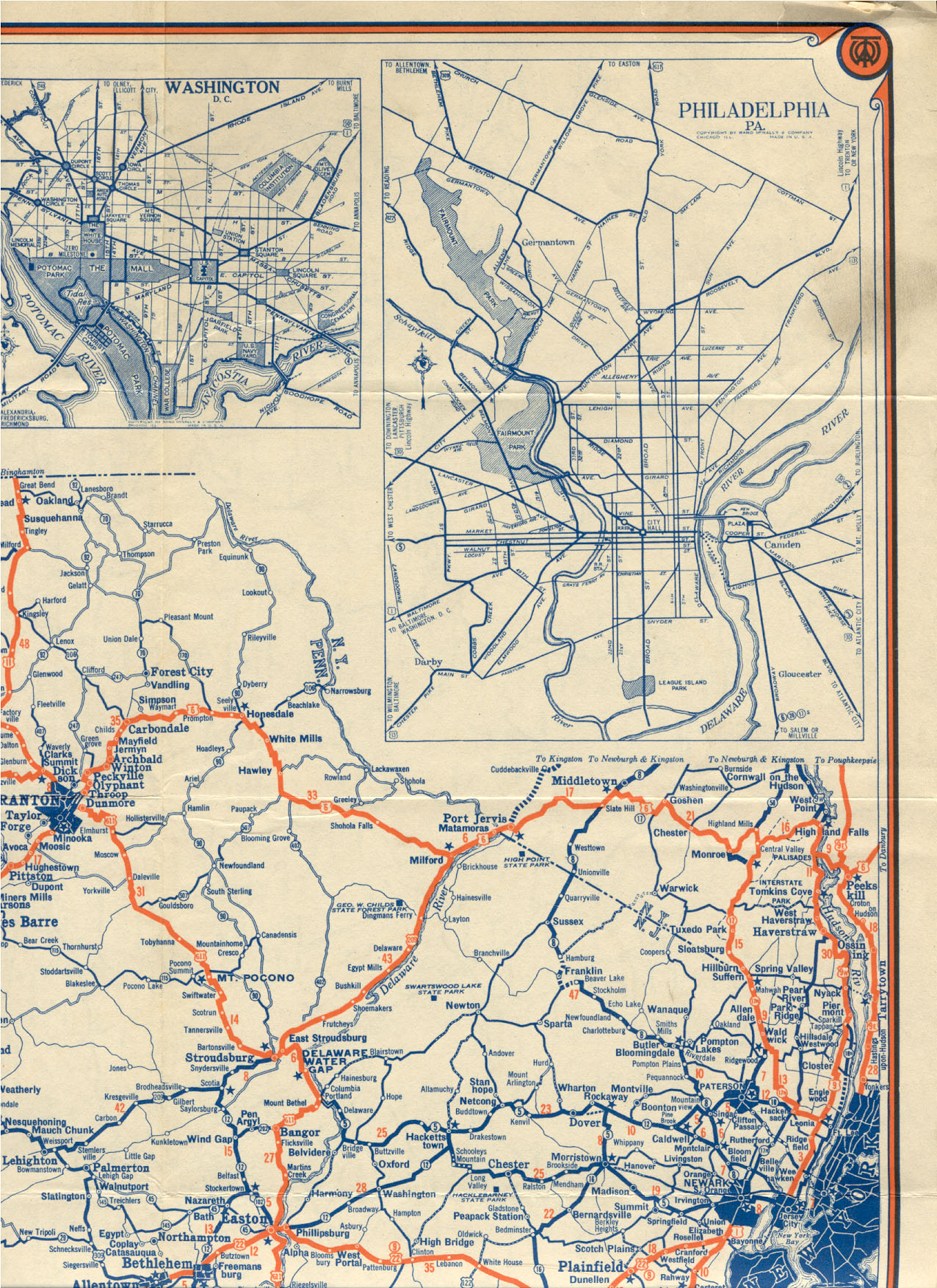
U.S. Route 9W (US 9W) is a north–south United States Numbered Highway in the states of New Jersey and New York. It begins in Fort Lee, New Jersey, as Fletcher Avenue crosses the US 1/9, US 46, and Interstate 95 (I-95) approaches to the George Washington Bridge, and heads north up the west side of the Hudson River to US 9 in Albany, New York. As its "W" suffix indicates, US 9W is a westerly alternate route of US 9 between the two locations. US 9W directly serves three cities—Newburgh, Kingston, and Albany—and enters the vicinity of several others. As the route heads north, it connects to several highways of regional importance, including I-84, US 209, New York State Route 23 (NY 23), and US 20. Much of US 9W parallels the New York State Thruway and NY 32; additionally, the latter overlaps with US 9W in four locations.
Route description
[edit]This section needs additional citations for verification. (January 2020) |
For much of its length, US 9W is a two-lane surface road. However, some stretches in New Jersey and New York widen to four lanes, and much of the highway in Orange County is like an expressway even if not so designated.
New Jersey
[edit]
US 9W begins as a four-lane road. Heading north on Fletcher Avenue (from Kelby Street intersection, near the George Washington Bridge) in Fort Lee, US 9W occupies the right-of-way of the Palisades Interstate Parkway (PIP) to Lemoine Avenue, the northern terminus of Route 67. US 9W exits the right-of-way, turning north onto Lemoine Avenue, later Sylvan Avenue, in Englewood Cliffs, where it passes the headquarters of Ferrari of North America, Unilever, and CNBC. As the roadway enters Tenafly from Englewood Cliffs, it reduces to a two lane roadway from four lanes. It continues to parallel the PIP to its west as they progress northward along the west bank of the Hudson River until reaching the border with New York. Both roads run very near the top of the Palisades, occasionally offering views of New York City and the river.
Lemoine Avenue is heavy with commercial development in the Coytesville section of Fort Lee, but, as the road runs into Englewood Cliffs, it transitions to corporate office buildings. Into the affluent community of Alpine in the state's northeastern corner, it becomes more residential. Near Norwood, just south of the state line, US 9W crosses under the parkway and enters New York. Before the construction of the PIP, US 9W used to follow a route through the State Line Lookout at the New Jersey–New York border which is now accessible only from the parkway.
The entire route of US 9W in New Jersey is within Bergen County.
New York
[edit]Rockland County
[edit]Across the state line, US 9W continues in Palisades as Highland Avenue, a two-lane road through mostly residential suburban surroundings. It passes Columbia University's Lamont–Doherty Earth Observatory and then Tallman Mountain State Park. Bending westward to Sparkill, it meets NY 340.
It returns to the riverside at Piermont, where it takes the name Broadway Avenue. Running due north, it enters Nyack and meets with the New York State Thruway (I-87 and I-287) just west of the Tappan Zee Bridge. It then runs along the thruway to the east terminus of NY 59 in downtown Nyack, where it becomes North Highland Avenue once again. North of Upper Nyack, it passes Rockland Lake through Valley Cottage and then Rockland Lake State Park.
Alongside the park, it crosses town lines again. NY 303 reaches its north end just after the park and, after a tight curve NY 304, reaches its northern terminus as well.
US 9W then returns to the riverside briefly, trending away from it into Haverstraw under the name Congers Avenue. The village is followed immediately by West Haverstraw, where US 202 comes in at an oblique angle and joins US 9W, creating the first concurrency along the route.
_Fleet.jpg)
The combined highways head north from the Haverstraws as South, then North, Liberty Drive, passing Stony Point Battlefield. They return to the Hudson at Tomkins Cove, where the Hudson River National Defense Reserve Fleet was moored from 1947 to 1971. Between Tomkins Cove and Jones Point there are two large ships anchor surrounding a monument alongside the road that marks the spot which is just across from Indian Point Energy Center in Buchanan.

At Jones Point, the road curves and bends above the river as it works its way around Dunderberg Mountain, the southernmost peak of the Hudson Highlands and part of Bear Mountain State Park.
At Iona Island, it levels out again briefly and then US 9W/US 202 climbs to the heart of the state park at Bear Mountain Inn and Hessian Lake, where the Appalachian Trail crosses beneath the road in the only artificial tunnel along its entire route. The Orange County line is crossed just before Bear Mountain Circle.
Orange County
[edit]
The circle marks the northern terminus of the PIP and the junction with US 6. US 202 leaves US 9W to join US 6 here and cross the Bear Mountain Bridge. North of the circle, US 9W continues as a four-lane surface road, crossing Popolopen Creek and affording views of the similarly named Torne. It passes first the historic Fort Montgomery, then enters the small hamlet of the same name, distinguished by a post office, gas station, and some other small businesses.
After becoming a four-lane expressway, NY 218 (Storm King Highway), the former route of US 9W, forks off to the right, carrying traffic to Highland Falls and the U.S. Military Academy (USMA) at West Point. US 9W then starts to climb the highlands above the village and the academy. The following exit is also for NY 218, which joins US 9W for a mile (1.6 km) just north of the village. It leaves the highway at the northern terminus of NY 293 to run alongside Storm King Mountain.

From here, US 9W continues its ascent, offering sweeping views over the river and highlands, with an overlook available to northbound drivers. The surrounding land is all woods, part of the vast USMA property. After passing Crow's Nest, Storm King and the rocky cliff faces of Butter Hill dominate the northward view. Another parking lot allows travelers to stop and sightsee, as well as hike the Stillman Trail up the two peaks.
After Storm King, the road begins a long descent into the town of Cornwall, where it becomes a two-lane surface road before becoming a four-lane arterial road. Just outside the village of Cornwall-on-Hudson and the fields of New York Military Academy, NY 218 ends its loop. Shortly afterward, the division ends, although the road remains four lanes as it enters the town of New Windsor.

It descends again where Breakneck Ridge and Bull Hill tower across the river. Traffic begins to slow down at the center of town, where NY 94 ends its journey across the county. After this traffic light, the road begins to narrow. Once across Quassaick Creek and into Newburgh, it is Robinson Avenue, a wide urban arterial with parking along the sides.
It ascends gently past Delano-Hitch Stadium and the associated park to the center of its passage across Newburgh, the intersection with Broadway. Here NY 17K has its eastern terminus, and NY 32, the other main surface route west of the Hudson, begins its first concurrency with US 9W.
Passing Broadway School, a former elementary school which is in the process of being converted into the City of Newburgh Court House, the two routes head into a more residential sector of the city, marked by Frederick Law Olmsted-designed Downing Park. The road's climb continues until the North campus of Newburgh Free Academy, where it starts to descend to the busy exit at I-84, visible ahead, just west of the Newburgh–Beacon Bridge. This junction, also including NY 52, is the city's northern limit.

Immediately after it, NY 32 leaves to the northwest while US 9W continues northward. It passes Powelton Club, part of the affluent community of Balmville, the first of several within the town of Newburgh that US 9W will pass. Middle Hope follows, as the road becomes a two-lane route with a rural feel. Development continues along the road, but there are increasingly large unbroken fields or woodlots and, finally, in the northern reaches of the town, orchards. At Roseton, past the access road to the nearby powerplants, the highway reaches the county line just past the turnoff to the Gomez Mill House, the earliest surviving Jewish home in the U.S.
Ulster County
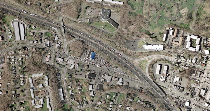
[edit]Traffic is slowed when it passes through the hamlet of Marlboro, but otherwise there is little change in US 9W until it widens to four lanes again just south of the Mid-Hudson Bridge approach overpass. At this point, US 44 and NY 55 join the highway from the east. The road becomes a busy commercial strip for the next mile to the concurrency's end, where NY 44 and NY 55 go down into Highland. The four lanes continue, however, for several more miles until well past the eastern terminus of NY 299, the road that carries traffic west toward the thruway and New Paltz.
About two miles (3.2 km) north of that intersection, the road returns to two lanes through West Park and Esopus, passing primarily through largely undeveloped, primarily wooded countryside. It becomes more built up at Port Ewen, just south of Kingston, which it enters by crossing Rondout Creek via the John T. Loughran Bridge and becoming a four-lane expressway known as Frank Koenig Boulevard.

It runs right through Kingston this way and meets NY 32 again at the city's northern boundary. Turning left, US 9W's second concurrency with NY 32 is only 500 feet (150 m) long as it almost immediately turns right onto East Chester Street. The road widens again, becoming a busy commercial strip. At the freeway interchange ahead for the Kingston–Rhinecliff Bridge, US 209 comes to its northern end and NY 199 its western.
In Lake Katrine, the road begins to narrow and traffic lightens. US 9W stays on a straight northward course, following alongside Esopus Creek but not crossing it, until it veers northeast to merge, once again, with NY 32.
This third concurrency finally brings the road over Esopus Creek and into the riverside village of Saugerties. Here, US 9W follows Partition Street and then Main Street when the routes part again, with NY 32 carrying NY 212 out of this junction. As Malden Avenue, the highway continues north alongside the river once again, passing through the hamlet of Malden-on-Hudson on its way up into Greene County.
Greene County and north
[edit]In Catskill, US 9W meets with NY 23A, then NY 385 at its southern terminus, and then, a mile (1.6 km) north, NY 23.
In Coxsackie, US 9W meets this time with the northern terminus of NY 385, as well as the eastern terminus of NY 81. In West Coxsackie, US 9W meets with the New York State Thruway (I-87). Further north, the route meets NY 144, and in the village of Ravena, it meets NY 143.
NY 396 meets US 9W in Selkirk. After briefly joining with NY 32 again, US 9W meets I-787 south of Albany. Immediately thereafter, NY 443 joins US 9W until Madison Avenue (US 20), where NY 443 ends. US 9W, however, continues on, meeting with NY 5 (junction not signed on NY 5) before ending at US 9 (Clinton Avenue).
History
[edit]Origins
[edit]In New York, much of what is now US 9W was designated as Route 3, an unsigned legislative route, by the New York State Legislature in 1908. The route extended from the New Jersey state line at Orangetown and went northward through the Hudson Valley to the city of Albany. Route 3 broke from modern US 9W in several locations, mostly in areas where the route has since been moved onto bypasses. In Clarkstown, Route 3 veered west to serve Congers via Lake and Old Haverstraw Roads. From Highland Falls to Cornwall-on-Hudson, Route 3 followed modern NY 218 around Storm King Mountain. Lastly, Route 3 utilized current NY 385 between Catskill and Coxsackie.[4][5] This route north of Route 3 was altered slightly on March 1, 1921, to bypass Congers on modern US 9W.[6] When the first set of posted routes in New York were assigned in 1924, all of legislative Route 3 south of Ravena was designated as part of NY 10. From Ravena to Albany, however, NY 10 followed a more easterly alignment along what is now NY 143, NY 144, and NY 32.[7][8][9] This route had previously been signed as part of the West Shore Route auto trail north of Newburgh.[10]
The New Jersey segment of modern US 9W was originally designated as part of Route 18N in 1923, a route that ran from Hoboken to the New York state line at Alpine via Fort Lee.[11] In the 1927 New Jersey state highway renumbering, Route 18N was truncated northward to Fort Lee. At the time, present-day County Route 501 (CR 501) north of Fort Lee was part of Route 1.[12] In 1929, Route 18N was supplanted by a realigned Route 1.[13] The Route 1 designation remained in place until the 1953 New Jersey state highway renumbering when it was removed to eliminate overlaps with several routes, including US 9W.[14][15]
Designation
[edit]_from_the_pedestrian_overpass_just_south_of_Orbach_Way_in_Alpine,_Bergen_County,_New_Jersey.jpg)
In the original 1925 plan for the U.S. Numbered Highway System, US 9 was designated along the west bank of the Hudson River from Fort Lee to Albany, utilizing Route 18N in New Jersey[16][17] and NY 10 in New York.[8][9] The alignment of US 9 in northern New Jersey and New York remained unchanged in the final system alignment approved on November 11, 1926.[18] However, when US 9 was commissioned in 1927, it was split into two branches between Bergen County, New Jersey, and Waterford, New York. The west branch began in Ridgefield and continued to the New York state line on modern Route 93 and CR 501, bypassing Fort Lee to the west. At the state line, the west branch of US 9 became US 9W and followed a short piece of what is now NY 340 to Sparkill.[19]
Past Sparkill, US 9W used what was originally planned as US 9 north to Waterford, utilizing modern NY 32 from Albany to Waterford.[3] The east branch of US 9 initially followed Route 5 east from Ridgefield to Edgewater, where it followed the Edgewater Ferry to the New York state line in the Hudson River.[20] The branch resumed at the northern New York City line as US 9E and continued to Waterford on what is now US 9 and US 4 along the eastern side of the river. At Waterford, the two branches converged and continued north toward the Canada–United States border as a unified US 9.[3]
Early changes
[edit]The two branches of US 9 in New Jersey were altered several times over the next decade. At some point between 1927 and 1929, the west branch of US 9 was reconfigured in Bergen County to enter Fort Lee from the south on Palisade Avenue (current Route 67) and proceed north from Fort Lee to New York on Route 18N (later Route 1). The portion of US 9W in New York south of Sparkill was altered accordingly to meet the realigned US 9.[19][20] In the early 1930s, the east branch of US 9 was shifted southward to reach New York via modern Route 139 and the Holland Tunnel while the west branch of the route was realigned to follow what is now US 1/9 between the Tonnele Circle and Fort Lee.[21][22] US 9W was extended southward into New Jersey c. 1932, replacing the west branch of US 9.[22][23] US 9 was rerouted c. 1934 to follow US 9W and the George Washington Bridge to New York; as a result, US 9W was cut back to its current southern terminus in Fort Lee.[24][25]
In the 1930 renumbering of state highways in New York, US 9W was truncated southward to end in Albany while US 9E was redesignated as just US 9 and reconfigured to bypass Waterford to the west in favor of a direct alignment between Albany and Round Lake.[26][27] At the same time, US 9W was realigned through New Baltimore and Coeymans to use modern NY 144 instead. The portion of what is now US 9W from New Baltimore to Albany was originally designated as NY 144 as part of the 1930 renumbering[20][21] while the segment from Catskill to Coxsackie was assigned NY 385 c. 1932.[22][23] The alignments of US 9W and NY 385 were swapped by the following year[24] while the routings of US 9W and NY 144 were flipped in April 1935.[28]
Bypasses
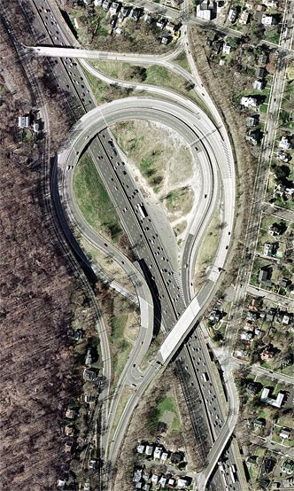
[edit]In the early 1930s, plans were made by the state of New York to construct a new highway between the Bear Mountain Bridge and Cornwall-on-Hudson that would bypass both Cornwall-on-Hudson and Highland Falls and bypass the narrow Storm King Highway, US 9W's original routing between the two. On April 8, 1934, three people were killed by a rockslide on the Storm King Highway, expediting plans for the new highway, known as the Storm King Cutoff.[29] The southernmost two miles (3.2 km) of the highway—from the bridge to just north of Fort Montgomery—utilized the existing right-of-way of US 9W,[30] which was widened from two to four lanes[29] and straightened through the construction of rock cuts. Construction on this segment was completed in 1937.[30]
The portion of the bypass from Fort Montgomery to Cornwall-on-Hudson, with the exception of a one-mile (1.6 km) stretch northwest of Highland Falls, was constructed on a new alignment. It was built with four lanes and constructed along the sides of Storm King Mountain and other, smaller hills in the area. The high elevation of the roadway gave rise to a bevy of scenic, panoramic views that stretched for several miles into the distance; as a result, a fifth lane was added in some areas to allow motorists to stop and view the scenery. Like the section south of Fort Montgomery, the one-mile (1.6 km) stretch that utilized the original US 9W was widened to four lanes as well. Several interchanges were built along the route, including with NY 293 and NY 307.[29] The cutoff was opened to traffic from Fort Montgomery to NY 293 sometime in 1939 or 1940 and to Angola Road (CR 9) on September 26, 1940.[29][31] The last section, from Angola Road north to Blooming Grove Turnpike north of Cornwall-on-Hudson, was opened to traffic on May 31, 1941. US 9W was realigned to follow the cutoff[32] while its old route via the Storm King Highway became NY 218.[33]
Bypasses have also been proposed or constructed in other locations. In Kingston, US 9W was originally routed on Wurts Street, McEntee Street, Broadway, and East Chester Street.[34] An easterly bypass of the city between Wurts Street and NY 32 was constructed in the late 1970s and completed as a realignment of US 9W by 1981.[35][36] The portion of US 9W's former alignment south of Abeel Street in Kingston became NY 984D, an unsigned reference route.[37] In Albany, the north end of US 9W and part of US 9 would have been rerouted onto a proposed limited-access highway called the Mid-Crosstown Arterial.[citation needed] The project was eventually canceled.[citation needed]
Major intersections
[edit]| State | County | Location | mi[1][2] | km | Destinations | Notes |
|---|---|---|---|---|---|---|
| New Jersey | Bergen | Fort Lee | 0.00 | 0.00 | Southern terminus; northern terminus of N.J. Turnpike; exits 72-74 on I-95 | |
| 0.17 | 0.27 | Interchange; eastern terminus of Route 4 | ||||
| 0.65 | 1.05 | Interchange; northbound exit and southbound entrance; access via Route 445S | ||||
| Interchange; southbound exit and northbound entrance; northern terminus of Route 67 | ||||||
| Englewood Cliffs | 2.19 | 3.52 | ||||
| Alpine | 7.19 | 11.57 | Eastern terminus of CR 502 | |||
| 7.77 | 12.50 | Exit 2 on Palisades Parkway | ||||
| 9.75 | 15.69 | Exit 3 on Palisades Parkway | ||||
| 10.46– 10.84 | 16.83– 17.45 | Exit 4 on Palisades Parkway | ||||
| 11.87 0.00 | 19.10 0.00 | New Jersey–New York state line | ||||
| New York | Rockland | Orangetown | Access via Highland Avenue; northbound exit and southbound entrance | |||
| Piermont | 2.63 | 4.23 | Access via Hickey Street/Highland Avenue | |||
| South Nyack | 5.99 | 9.64 | Exit 10 on I-87 / I-287 / Thruway | |||
| Nyack | 7.11 | 11.44 | Eastern terminus of NY 59 | |||
| 7.21 | 11.60 | Access via High Avenue; exit 11 on I-87 / I-287 / Thruway | ||||
| Clarkstown | 12.81 | 20.62 | Northern terminus of NY 303 | |||
| 13.42 | 21.60 | Northern terminus of NY 304 | ||||
| Village of Haverstraw | 15.87 | 25.54 | Westside Avenue (NY 981F north) | |||
| 16.27 | 26.18 | Southern end of US 202 concurrency | ||||
| Stony Point | Access via South Entrance Road | |||||
| Southbound exit and northbound entrance; northern terminus of Seven Lakes Drive | ||||||
| Orange | Highlands | 26.67 | 42.92 | Bear Mountain Circle; northern end of US 202 concurrency; eastern terminus of US 6 Truck; northern terminus of Palisades Parkway | ||
| 28.46 | 45.80 | Old State Road (NY 980U north) | ||||
| Southern end of limited-access section | ||||||
| Highland Falls | 29.36 | 47.25 | Southern terminus of NY 218 | |||
| Highlands | 31.31 | 50.39 | Southern end of NY 218 concurrency | |||
| 32.07 | 51.61 | Northern end of NY 218/US 6 Truck concurrency; northern terminus of NY 293 | ||||
| Cornwall | 37.62 | 60.54 | Angola Road (CR 9) | |||
| 38.06 | 61.25 | Former NY 307; hamlet of Firthcliffe; NY 32 not signed northbound | ||||
| Northern end of limited-access section | ||||||
| 38.66 | 62.22 | Willow Avenue (CR 32) | Interchange; hamlet of Firthcliffe | |||
| 39.51 | 63.59 | Interchange; northern terminus of NY 218 | ||||
| Town of New Windsor | River Road | Interchange; no southbound exit; hamlet of New Windsor | ||||
| 42.30 | 68.08 | Northern terminus of NY 94 | ||||
| City of Newburgh | 43.22 | 69.56 | Eastern terminus of NY 17K; southern end of NY 32 concurrency | |||
| South Street (NY 980P) | Former NY 52 | |||||
| Town of Newburgh | 44.52– 44.58 | 71.65– 71.74 | Exit 39 on I-84; northern end of NY 32 concurrency; hamlet of Balmville | |||
| Ulster | Lloyd | 58.47 | 94.10 | Interchange; southern end of US 44/NY 55 concurrency | ||
| 59.03 | 95.00 | Northern end of US 44/NY 55 concurrency; hamlet of Highland | ||||
| 60.91 | 98.03 | Eastern terminus of NY 299 | ||||
| Esopus | 72.92 | 117.35 | Old Route 9W (NY 984D north) | Former routing of US 9W; hamlet of Port Ewen | ||
| Southern end of limited-access section | ||||||
| City of Kingston | 74.12 | 119.28 | Delaware Avenue | |||
| Ulster | 75.37 | 121.30 | Northern end of limited-access section | |||
| Southern end of NY 32 concurrency | ||||||
| City of Kingston | 75.65 | 121.75 | Northern end of NY 32 concurrency | |||
| Ulster | 76.96 | 123.86 | Ulster Avenue (NY 981M south) | |||
| 78.04 | 125.59 | Interchange; northern terminus of US 209; western terminus of NY 199 | ||||
| Town of Saugerties | 83.70 | 134.70 | Southern end of NY 32 concurrency | |||
| Village of Saugerties | 85.92 | 138.27 | Northern end of NY 32 concurrency; eastern terminus of NY 212 | |||
| Greene | Village of Catskill | 96.33 | 155.03 | Eastern terminus of NY 23A | ||
| 96.88 | 155.91 | Southern terminus of NY 385 | ||||
| Town of Catskill | 98.13 | 157.92 | Interchange | |||
| Town of Coxsackie | 107.54 | 173.07 | Eastern terminus of NY 81; northern terminus of NY 385 | |||
| 107.74 | 173.39 | Mansion Street Extension (NY 910U south) | Former routing of US 9W | |||
| Town of New Baltimore | 109.73 | 176.59 | Exit 21B on I-87 / Thruway | |||
| 112.02 | 180.28 | Southern terminus of NY 144 | ||||
| Albany | Ravena | 115.03 | 185.12 | |||
| Bethlehem | 120.74 | 194.31 | Hamlet of Beckers Corners | |||
| 125.91 | 202.63 | Interchange; southern end of NY 32 concurrency | ||||
| 126.30 | 203.26 | Northern end of NY 32 concurrency | ||||
| Albany | 127.10 | 204.55 | Exit 23 on I-87 / Thruway; exit 1 on I-787 | |||
| 127.96 | 205.93 | Southern end of NY 443 concurrency | ||||
| 129.31 | 208.10 | Eastern terminus of NY 443 | ||||
| 129.68 | 208.70 | |||||
| 129.96 | 209.15 | Northern terminus | ||||
1.000 mi = 1.609 km; 1.000 km = 0.621 mi
| ||||||
See also
[edit]References
[edit]- ^ a b "US 9W Straight Line Diagram" (PDF). New Jersey Department of Transportation. May 2009. Retrieved March 17, 2020.
- ^ a b "2008 Traffic Volume Report for New York State" (PDF). New York State Department of Transportation. June 16, 2009. pp. 30–32. Retrieved May 26, 2010.
- ^ a b c Automobile Blue Book. Vol. 1 (1927 ed.). Chicago: Automobile Blue Book, Inc. 1927. This edition shows U.S. Routes as they were first officially signed in 1927.
- ^ State of New York Department of Highways (1909). The Highway Law. Albany, NY: J. B. Lyon Company. p. 54. Retrieved May 26, 2010.
- ^ New York State Department of Highways (1920). Report of the State Commissioner of Highways. Albany, NY: J. B. Lyon Company. pp. 499–500. Retrieved May 26, 2010.
- ^ New York State Legislature (1921). "Tables of Laws and Codes Amended or Repealed". Laws of the State of New York passed at the One Hundred and Forty-Fourth Session of the Legislature. Albany, NY: J. B. Lyon Company. pp. 42, 45–46. Retrieved May 26, 2010.
- ^ "New York's Main Highways Designated by Numbers". The New York Times. December 21, 1924. p. XX9.
- ^ a b Rand McNally Auto Road Atlas (western New York) (Map). Rand McNally and Company. 1926. Retrieved May 26, 2010.
- ^ a b Rand McNally Auto Road Atlas (eastern New York) (Map). Rand McNally and Company. 1926. Retrieved May 26, 2010.
- ^ "Rand McNally official 1920 auto trails map, New York City and vicinity". Library of Congress, Washington, D.C. 20540 USA. Retrieved July 3, 2022.
- ^ "Route No. 18-N From Hoboken to New York State line by way of Weehawken, West Hoboken, town of Union, North Bergen, Fairview, Ridgefield, Palisade Park, Fort Lee, Englewood-Cliffs, Tenafly and Alpine". New Jersey State Legislations. New Jersey State Legislature. 1923.
- ^ State of New Jersey, Laws of 1927, Chapter 319.
- ^ ROUTE NO. 1. Alpine to Bayonne. Beginning at the New York state line on state highway route heretofore designated as Route No. 18--north in Alpine and terminating in Bayonne, by way of Alpine, Tenafly, Fort Lee and Ridgefield, in Bergen county, North Bergen, Jersey City and Bayonne, in Hudson county. L. 1929, c. 126, p. 215, s. 1.
- ^ "1953 renumbering". New Jersey Department of Highways. Archived from the original on June 28, 2011. Retrieved July 31, 2009.
- ^ "New Road Signs Ready in New Jersey". The New York Times. December 16, 1952. Archived from the original on July 21, 2011. Retrieved July 20, 2009.
- ^ Report of Joint Board on Interstate Highways. Bureau of Public Roads. October 30, 1925. Retrieved February 24, 2018.
- ^ New York and Vicinity (Map). Rand McNally and Company. 1926. Retrieved May 26, 2010.[permanent dead link]
- ^ Bureau of Public Roads & American Association of State Highway Officials (November 11, 1926). United States System of Highways Adopted for Uniform Marking by the American Association of State Highway Officials (Map). 1:7,000,000. Washington, DC: United States Geological Survey. OCLC 32889555. Retrieved November 7, 2013 – via Wikimedia Commons.
- ^ a b 1927 Tydol Trails Map (north New Jersey) (Map). Tydol Oil Company. Retrieved May 26, 2010.
- ^ a b c New York in Soconyland (Map). Cartography by General Drafting. Standard Oil Company of New York. 1929.
- ^ a b Road Map of New York (Map). Cartography by General Drafting. Standard Oil Company of New York. 1930.
- ^ a b c Texaco Road Map – New York (Map). Cartography by Rand McNally and Company. Texas Oil Company. 1932.
- ^ a b New York (Map). Cartography by H.M. Gousha Company. Kendall Refining Company. 1931.
- ^ a b Texaco Road Map – New York (Map). Cartography by Rand McNally and Company. Texas Oil Company. 1933.
- ^ "Mark Ways in the City". The New York Times. December 16, 1934. p. XX12.
- ^ Automobile Legal Association (ALA) Automobile Green Book, 1930–31 and 1931–32 editions, (Scarborough Motor Guide Co., Boston, 1930 and 1931). The 1930–31 edition shows New York state routes prior to the 1930 renumbering
- ^ Dickinson, Leon A. (January 12, 1930). "New Signs for State Highways". The New York Times. p. 136.
- ^ "Route Changes in State Listed". New York Post. March 30, 1935. p. 18. Retrieved June 13, 2017.
- ^ a b c d Mathieu, George M. (August 6, 1939). "Storm King Cut-Off Pushed". The New York Times. pp. XX1, XX10.
- ^ a b "Route U.S. 9W Improved". The New York Times. November 21, 1937. p. 196.
- ^ Mathieu, George M. (September 22, 1940). "A New Route North". The New York Times. p. XX1.
- ^ Mathieu, George M. (May 25, 1941). "A Cut-Off With Views". The New York Times. p. XX2.
- ^ New York with Pictorial Guide (Map). Cartography by General Drafting. Esso. 1942.
- ^ Official Highway Map of New York State (Map) (1947–48 ed.). Cartography by General Drafting. State of New York Department of Public Works.
- ^ New York (Map). Cartography by General Drafting. Exxon. 1979.
- ^ I Love New York Tourism Map (Map). Cartography by Rand McNally and Company. State of New York. 1981.
- ^ New York State Department of Transportation (January 2012). Official Description of Highway Touring Routes, Bicycling Touring Routes, Scenic Byways, & Commemorative/Memorial Designations in New York State (PDF). Retrieved February 1, 2012.
External links
[edit]- U.S. Route 9W at Alps' Roads • New York Routes
- An enlarged view of road jurisdiction at the Fort Lee approaches to the George Washington Bridge (PDF)
- New Jersey Roads: US 9W
- US 9W @ NYS Thruway Exit 10 (Empire State Roads.com)
- US 9W @ NYS Thruway Exit 11 (Empire State Roads.com)
- Capital Highways -- Mid-Crosstown Arterial
- Police Scanner Frequencies for Route 9W
- Speed Limits for Route 9W in New Jersey
U.S. Route 9W
View on GrokipediaRoute description
New Jersey
U.S. Route 9W enters New Jersey at its southern terminus in Fort Lee, Bergen County, where it connects via a partial cloverleaf interchange with Interstate 95, U.S. Route 1, U.S. Route 9, and U.S. Route 46 at milepost 0.00.[5] This interchange facilitates access to the George Washington Bridge and provides ramps for northbound and southbound movements, serving as a critical link for local and interstate traffic.[4] As the route progresses north through urban areas, it encounters at-grade intersections with traffic signals and turning lanes to manage congestion. A notable example is the intersection with County Route 505 (Palisade Avenue) in Englewood Cliffs at approximately milepost 2.19, where dedicated turning lanes accommodate cross-traffic and access to nearby commercial areas.[5] The New Jersey segment concludes at the state line near Alpine, at milepost 11.17, where U.S. Route 9W continues directly into New York without a numbered junction or interchange, transitioning seamlessly into Rockland County.[5]| Milepost | Locations | Notes |
|---|---|---|
| 0.00 | Fort Lee; I-95 / US 1 / US 9 / US 46 | Southern terminus; partial cloverleaf interchange with ramps to/from eastbound/westbound I-95 and local routes; no concurrency.[5][4] |
| 2.19 | Englewood Cliffs; CR 505 (Palisade Avenue) | At-grade intersection with traffic signals and turning lanes; provides access to Palisades Parkway via local connections.[5] |
| 11.17 | Alpine; New York state line | Direct continuation into New York; no ramps or numbered exit; end of New Jersey maintenance.[5] |
Rockland County, New York
U.S. Route 9W enters Rockland County from New Jersey near the community of Alpine, transitioning into a two-lane undivided road that winds northward through the rugged terrain of the Palisades escarpment and the southern fringes of the Hudson Highlands.[6] The highway immediately passes through the hamlets of Palisades and Sparkill in the town of Orangetown, crossing Sparkill Creek via a small bridge and providing access to Tallman Mountain State Park before reaching the village of Piermont, where it follows Piermont Avenue amid historic waterfront settings along the Hudson River.[6] Continuing north, 9W traverses the village of Grand View-on-Hudson, offering occasional vistas of the river and the Palisades cliffs, before intersecting the Palisades Interstate Parkway (I-87/I-287) and entering the village of Nyack, where it meets the eastern terminus of New York State Route 59 (NY 59) at a signalized junction serving local commuter traffic.[6][7] In central Rockland County, the route shifts to more suburban surroundings as it proceeds through Valley Cottage and Congers in the town of Clarkstown, crossing county roads like Lake Road (CR 80) that lead to Rockland Lake State Park for recreational access.[6] Northward into the town of Haverstraw, 9W becomes Conger Avenue and begins a brief multiplex with U.S. Route 202 (US 202), passing through West Haverstraw and Stony Point with connections to NY 304 and county routes facilitating both residential commuting and park-bound visitors.[6][7] The highway totals 26.54 miles (42.72 km) within the county, emphasizing its role in linking urban edges to natural areas.[7] North of Stony Point, 9W enters more rural landscapes along the Hudson shoreline in Tomkins Cove, where it parallels the river closely with steep cliffs rising on the west and offers proximity to Harriman State Park via local roads.[6] Notable features include expansive views of Dunderberg Mountain across the Hudson and the western approach to the Bear Mountain Bridge, where the route intersects NY 210 and continues as a four-lane divided section briefly before US 202 diverges toward the bridge.[6][8] County roads such as Wayne Avenue (CR 112) and Buckberg Road (CR 53) branch off here, supporting recreational traffic to state parks and trails, before 9W exits northward into Orange County amid the Highland's forested hills.[6][9]Orange County, New York
U.S. Route 9W enters Orange County from Rockland County just north of the Bear Mountain Bridge, immediately beginning a steep climb into the Hudson Highlands as it traverses the county's mountainous interior for 23.23 miles (37.39 km).[10] The route passes through the hamlet of Fort Montgomery, skirts the eastern edge of the U.S. Military Academy at West Point in the village of Highland Falls, and continues through the village of Cornwall-on-Hudson, offering drivers glimpses of the academy's historic grounds and the Hudson River below.[11] Northward, it winds through the town of Cornwall before reaching the town of New Windsor. Key engineering features along the route include the Popolopen Bridge, a 600-foot (180 m) deck truss structure built in 1936 that spans Popolopen Creek near Fort Montgomery, rising 150 feet (46 m) above the water to accommodate the rugged terrain.[12] Further north, the Storm King Bypass, completed in sections starting in 1940, provides a four-lane cutoff west of Storm King Mountain to avoid the original route's steep 12 percent grades and sharp curves, improving safety and access through the highlands.[13] These features highlight the challenges of constructing a highway through the geologically complex Hudson Highlands. Beyond New Windsor, U.S. Route 9W enters more rural stretches, passing near industrial areas in the city of Newburgh while maintaining proximity to Interstate 84 and intersecting New York State Route 32 in Newburgh and New York State Route 17K south of the city. The route remains predominantly two lanes undivided, with occasional widening to four lanes, and features scenic overlooks providing panoramic views of the Hudson River and the prominent Storm King Mountain, designated as part of New York's scenic byways for its natural beauty.[14] These vistas, accessible from pullouts along the highway, emphasize the route's role as a gateway to the Hudson Valley's dramatic landscape before crossing into Ulster County.Ulster County, New York
Upon entering Ulster County from Orange County in the town of Lloyd, U.S. Route 9W descends from the highland terrain near the Storm King area into the flatter Hudson Valley floor, providing access to the vicinity of Newburgh with connections to New York State Route 300 and Interstate 84.[15] The route spans 40.54 miles (65.23 km) through the county, traversing a mix of rural and urban landscapes while paralleling the Hudson River's western bank.[10] In southern Ulster County, US 9W passes through the towns of Plattekill and Lloyd, characterized by two-lane undivided sections amid agricultural and residential areas, before reaching the village of Highland in the town of Lloyd. Here, it intersects New York State Route 55, offering a connection to the Mid-Hudson Bridge across the Hudson River to Poughkeepsie in Dutchess County.[16] The highway continues northward through the town of Esopus, maintaining its two-lane rural configuration and serving local freight traffic along with tourism to nearby attractions in the Shawangunk Mountains via intersecting routes like New York State Route 299. Proximity to the CSX rail line underscores its role in regional logistics.[17] Further north, US 9W enters the town of Ulster, where it transitions into denser commercial development, including major retail centers around the intersection with New York State Route 209. In this area, the route briefly expands to four or five lanes with partial division to accommodate higher urban traffic volumes. It then proceeds into the city of Kingston, New York's first capital and a key Hudson Valley hub with significant waterfront activity along the river. Through Kingston, US 9W features four-lane divided sections, facilitating both commuter and tourist flows to historic sites and the Walkway Over the Hudson, a pedestrian rail trail accessible nearby in Highland. The corridor supports substantial commercial and residential growth, with ongoing developments enhancing mixed-use connectivity.[18][19] Exiting Kingston northward via the town of Ulster and into Saugerties, US 9W reverts to two-lane rural alignment, passing through wooded and residential zones while linking to the northern county's commercial strips and intercounty routes toward Greene County. This segment emphasizes scenic views of the Catskill foothills and bolsters tourism to the Hudson Valley's cultural and natural resources.[20]Greene and Albany Counties, New York
U.S. Route 9W enters Greene County from Ulster County at milepost 90.31 and proceeds northward for 24.23 miles along the west bank of the Hudson River, primarily as a two-lane undivided roadway through rural landscapes featuring farmland and wooded areas with occasional views of the river and Catskill Mountains.[21][10] In the village of Catskill, the route intersects NY 23A at milepost 96.33, NY 385 (its southern terminus) at 96.88, and NY 23 at 98.13 near the Rip Van Winkle Bridge, which carries NY 23 across the Hudson; here, the road briefly follows local streets like West Bridge Street before continuing north.[10] North of Catskill, US 9W passes through the town of Athens, intersecting County Route 28 at milepost 102.27 west of the village, and then reaches the hamlet of Jeansville, where it meets NY 81 (east) and NY 385 (north) at milepost 107.54.[10] Further north in Greene County, the route crosses the New York State Thruway (I-87) at Exit 21B near milepost 109.73 and enters the town of New Baltimore, intersecting NY 144 at milepost 112.02 before reaching the Albany County line at milepost 114.54.[10] Throughout this segment, US 9W winds through scenic terrain designated as part of the Hudson River Valley National Heritage Area, offering drivers panoramic vistas of the Hudson River and surrounding hills, with the road serving as a key corridor for local traffic and tourism in the Catskills region.[19] The highway passes through small communities like Coxsackie, where it supports access to riverside parks and historic sites along the waterfront.[22] Crossing into Albany County at milepost 114.54, US 9W continues for 15.42 miles, transitioning from rural two-lane sections to more suburban and urban four-lane divided alignments as it approaches the capital city.[10] In southern Albany County, the route serves the villages of Ravena and Coeymans, intersecting NY 143 at milepost 115.03 and passing through industrial zones near the Hudson shoreline before entering the town of Bethlehem.[10] Here, it meets NY 396 at milepost 120.74 amid farmland and residential areas, then overlaps briefly with NY 32 starting at milepost 125.91 south of the city of Albany.[10] The highway gains a more urban character, intersecting I-787 at Exit 1 (also I-87 Exit 23) at milepost 127.10 and NY 443 westbound at 127.96, providing connections to the Albany Riverfront and downtown districts.[10] In downtown Albany, US 9W follows Delaware Avenue and Lark Street, crossing NY 443 (east) and NY 20 at milepost 129.31 and NY 5 at 129.68, before reaching its northern terminus at the intersection with US 9 (Clinton Avenue) at milepost 129.96, located approximately 0.5 miles south of the New York State Capitol building.[10] This final stretch incorporates mixed-use zones with commercial and governmental landmarks, marking the end of the route's journey parallel to the Hudson River through a blend of scenic rural byways, agricultural lands, and developing suburban-industrial corridors.[19]History
Origins
The origins of U.S. Route 9W trace back to a network of 19th-century turnpikes that facilitated stagecoach travel along the west bank of the Hudson River, serving as vital links between New York City and Albany before the advent of railroads and automobiles. These private toll roads, chartered under New York State laws beginning in the late 18th century, improved upon earlier colonial paths and Native American trails to provide more reliable overland transport amid the region's rugged terrain. Key examples include the Highland Turnpike, chartered in 1804 and operational by 1806, which extended from near King's Bridge in Manhattan northward through the Hudson Highlands to Poughkeepsie, offering a flatter alternative to river ferries and east-bank routes for passengers and freight. By 1807, New York had chartered 67 such turnpikes totaling over 3,000 miles statewide, with several hugging the Hudson's western shore to connect rural settlements in Rockland, Orange, and Ulster counties to urban markets, though many struggled financially due to competition from steamboats after 1807.[23][24][25] In the early 1900s, these turnpikes evolved into formalized state routes under New York's 1908 Highway Law, which established the Department of Highways and designated legislative routes for systematic improvement. Much of the future alignment of U.S. Route 9W in New York followed Legislative Route 3, an unsigned path from New York City northward along the Hudson's west bank through Rockland, Orange, Ulster, Greene, and Albany counties to Albany, spanning approximately 180 miles and incorporating upgraded sections of the old turnpikes. This route addressed the limitations of 19th-century infrastructure by prioritizing state-funded enhancements, such as macadam surfacing and bridge reinforcements, to accommodate growing bicycle and early automobile traffic amid the Good Roads Movement. By 1914, efforts included widening roads, reducing grades, and eliminating sharp curves in the Hudson Valley, particularly around Albany where concrete pavements appeared as early as 1910 to handle increased vehicular loads.[25][25] In New Jersey, the southern precursor to U.S. Route 9W drew from pre-1920s local roads originating in Fort Lee and extending north along the Palisades cliffs, building on colonial paths that followed Lenape trails for access to the Hudson River's west bank. These included the Old Palisade Road, a narrow, winding route used since the 18th century for local trade and travel between settlements like Edgewater and Alpine, often impassable in wet conditions until gradual improvements in the late 19th century. The 1917 New Jersey State Highway Act formalized parts of this corridor as Route 10, running from Paterson through Hackensack to Fort Lee at the Hudson, while early segments of what became Henry Hudson Drive—constructed starting in 1912—provided a scenic riverside path northward, enhancing connectivity to New York State routes. These paths, initially gravel-surfaced and aligned with the steep Palisades topography, supported cross-river ferries and local commerce before broader state intervention.[26][27][28] Initial paving efforts between 1910 and 1920 transformed these precursors from seasonal dirt tracks into reliable all-weather connections between rural Hudson Valley communities and urban centers like New York City and Albany. Influenced by the 1916 Federal Aid Road Act, which provided $75 million nationwide for highway improvements, New York prioritized bituminous macadam and concrete surfaces along the west bank, with over 2,800 miles of state highways enhanced by 1920, including key stretches in Orange and Ulster counties to bypass flood-prone lowlands. In New Jersey, similar initiatives under the 1891 State Aid Highway Act extended to Palisades-area roads, funding macadam upgrades near Fort Lee to link with New York ferries. These developments reduced travel times and maintenance costs, enabling year-round access for farmers and merchants while setting the stage for expanded use.[25][26] The route's alignment played a pivotal role in early automobile tourism along the Hudson, predating federal highway numbering by capitalizing on the river's scenic vistas to attract motorists seeking leisure drives in the 1910s. Promoted through auto trail associations, these roads drew urbanites from New York for day trips to spots like Bear Mountain, fostering a boom in roadside inns and viewpoints. By the mid-1910s, improved surfaces along what would become U.S. Route 9W supported the era's "gypsy tours" and emerging parkways, such as early sections of Henry Hudson Drive, which offered uncluttered views of the river and Palisades for early Model T owners exploring the valley's natural beauty.[29]Designation
U.S. Route 9W was created under the U.S. Numbered Highway System, which was approved by the American Association of State Highway Officials on November 11, 1926, and officially implemented with designations announced in 1927.[30][31] As a westerly alternate to U.S. Route 9, it provided a parallel path along the west bank of the Hudson River, facilitating north-south travel through New Jersey and New York while offering access to scenic western Hudson Valley areas and relieving congestion on the primary east-bank alignment of US 9.[31] The route's initial endpoints were established at Fort Lee, New Jersey—near the George Washington Bridge—and Albany, New York, spanning approximately 140 miles (225 km).[31] In New Jersey, the southern segment followed the alignment of State Highway Route 18N, which had been designated in 1923 to connect Hoboken northward to the New York state line, and this pre-existing path was directly incorporated into US 9W upon its federal designation.[31] The New York portion largely overlaid the former New York State Route 3, a key highway established under the 1909 Highway Law that traversed the west side of the Hudson from the New Jersey border to Albany.[31] Signage for US 9W began appearing along the route by 1928, marking the full rollout of the federal highway markings in the region as states coordinated with AASHO guidelines.[30]Early changes
Following its designation in 1927, U.S. Route 9W underwent several modifications in the late 1920s and early 1930s to improve connectivity in northern New Jersey. In 1931, planning advanced for an extension from the New York state line southward through Fort Lee to better integrate with the newly opened George Washington Bridge, which provided a direct Hudson River crossing and spurred regional access to Palisades Interstate Park. This extension, incorporating elements of the Regional Plan's proposed parkway along the Palisades cliffs, began construction in 1933 and established the route's southern terminus at the bridge approaches in Fort Lee, replacing prior local alignments and enhancing links between Bergen and Passaic Counties.[32] By 1934, the route experienced a significant rerouting in Rockland County, New York, to optimize alignment for increasing traffic flows following the George Washington Bridge's opening three years earlier; this adjustment shifted southern access northward, incorporating new roads west of the Palisades such as New York Route 3 and New Jersey Route 18, and extended the highway to Alpine while addressing local needs through 178 contracted bridge projects statewide. These changes reflected broader efforts by the New York State Department of Public Works to standardize infrastructure, including the introduction of I-beam bridge designs.[25] During the 1940s, wartime priorities prompted improvements along U.S. Route 9W near West Point for military transport, including enhanced road and bridge maintenance to support defense-related trucking despite material shortages that halted many non-essential projects—only 12 contracts in 1942 met urgent military requirements. In Ulster County, mid-1950s adjustments prepared the route for integration with the Newburgh-Beacon Bridge, with planning documented as early as 1948 and formalized in a 1955 joint report by the Triborough Bridge and Tunnel Authority and Port Authority, involving realignments to accommodate the new crossing's approaches.[25] These cumulative modifications lengthened U.S. Route 9W to approximately 142 miles (228 km) by 1958, incorporating four-lane segments in urban areas like Albany and Kingston to handle growing vehicular demand, as part of the state's highway system completion by 1960.[25]Bypasses and later improvements
The Storm King Cutoff, a 2-mile (3.2 km) four-lane bypass in Orange County, was constructed between 1935 and 1941 to replace the narrow and hazardous Storm King Highway section of US 9W.[33][34] This project eliminated sharp curves and steep grades on the original alignment, improving safety and accommodating increased traffic along the Hudson River corridor.[33] Upon completion, US 9W was realigned onto the cutoff, with the former route redesignated as NY 218.[33] In Greene County, the Rip Van Winkle Bridge, opened in 1935, provided a vital crossing over the Hudson River at Catskill, linking US 9W on the west bank to NY 9G on the east.[35] The 5,040-foot (1,540 m) cantilever truss structure was built to facilitate commerce and travel, rising 145 feet (44 m) above the water to allow passage of freighters bound for Albany.[35] Major rehabilitation efforts in the late 1980s and early 1990s addressed structural wear, ensuring continued service while preserving its historic design.[36] Further north in Ulster County, the Mid-Hudson Bridge underwent significant expansions during the mid-20th century to handle growing vehicular demand.[37] In 1949, the eastern approach in Poughkeepsie was widened from two to three lanes, with an additional tollbooth added.[37] By 1966–1967, new approaches opened on both sides, including trumpet interchanges connecting to US 9W on the west and US 9 on the east, enhancing access and traffic flow for the suspension bridge carrying US 44 and NY 55.[37] These upgrades transformed the crossing into a more efficient link between the Hudson's west and east banks. Safety enhancements along US 9W in Rockland and Albany Counties during the 1960s through 1980s focused on adding shoulders and repaving sections to reduce accidents on the two-lane highway.[38] In Rockland County, these improvements addressed high-traffic volumes near the Palisades Interstate Parkway, while in Albany County, similar work near the Hudson River aimed to mitigate risks from weather and curvature.[38] Late 20th-century initiatives emphasized preserving US 9W's scenic and historic qualities amid rising truck traffic. The designation of the Hudson River Valley National Heritage Area in 1996 promoted balanced development, integrating transportation needs with conservation of viewsheds and cultural sites along the route.[39] Efforts included zoning adjustments and byway management plans to limit heavy truck impacts on residential and scenic segments, ensuring the highway's role as a heritage corridor.[40]Recent developments
2020s construction projects
In 2023, the New York State Department of Transportation announced plans to replace the structurally deficient U.S. Route 9W bridge over the CSX Railroad in the Town of Bethlehem near Ravena, Albany County, with bidding on March 13, 2025, construction to follow, and completion scheduled for October 31, 2027.[41][42] The project includes temporary lane reductions from two lanes in each direction to one during structural work to enhance safety and capacity.[41] Construction related to the Champlain Hudson Power Express project commenced on August 1, 2024, along U.S. Route 9W in Haverstraw, Rockland County, involving underground cable installation that necessitated paving restorations and detours.[43] Work impacted southbound lanes between Long Clove Road and Tilcon, with full roadway restoration and curb-to-curb paving planned upon completion in mid-2026.[44][45] In March 2025, the New Jersey Department of Transportation advanced plans for replacement of the Route 9W (Fletcher Avenue) bridge over I-95, Routes 1&9, 46, and Route 4 in Fort Lee, Bergen County, to address its poor structural condition, with construction to follow issuance of a letter of intent in Spring 2026.[4] The upgrades feature new 8-foot-wide shoulders on Route 9W, continuous 6-foot sidewalks with pedestrian ramps for improved connectivity, and enhanced vertical and lateral clearances over Route 4 to boost safety and traffic flow.[4] A $2.2 million resurfacing and safety improvement project began in August 2025 on a 2.7-mile segment of U.S. Route 9W from Canal Street in Port Ewen, Esopus, to State Route 32 in the Town of Ulster, encompassing parts of Kingston.[46] Enhancements include upgraded traffic signals, improved drainage systems, and installation of ADA-compliant curb ramps, along with milling, warm-mix fiber-reinforced asphalt resurfacing, and reflective striping to enhance visibility and accessibility.[46] The southbound Palisades Interstate Parkway Exit 9W ramp to northbound I-87 (New York State Thruway) in Clarkstown, Rockland County, faced significant delays in 2025 due to ongoing construction, originally slated for completion by July but remaining closed through November 16, 2025, when it reopened.[47][48] The extended closure disrupted access for northbound Thruway travelers from U.S. Route 9W, prompting detours and increased congestion in the area.[47]Future plans
In New York, the New York State Department of Transportation (NYSDOT) has included several projects for U.S. Route 9W in its Statewide Transportation Improvement Program (STIP) for fiscal years beyond 2025, focusing on safety and capacity enhancements in Greene County. These include proposed shoulder widening along segments in the county to improve bicycle and pedestrian safety, as well as traffic calming measures in the village of Catskill, such as signal upgrades and intersection improvements at key points like Route 9W and Leeds Athens Road.[49][50] At the northern terminus in Albany, enhancements to U.S. Route 9W are linked to the ongoing Reimagining I-787 Corridor project, which aims to redevelop the highway's waterfront alignment for better multimodal connectivity. Proposed improvements include new bike and pedestrian links connecting U.S. Route 9W to the Hudson River waterfront, with preliminary designs targeting completion by 2028 to support economic revitalization and community access.[51][52] The 2023 Ulster County Route 9W Corridor Management Plan, developed by the Ulster County Transportation Council in collaboration with local towns and NYSDOT, outlines long-term strategies extending to 2030 for the corridor from Marlboro to Blue Point Road. Key recommendations include bus stop upgrades, such as adding level surfaces and seating at the Milton Turnpike intersection, and development controls like zoning restrictions in the Business Corridor Overlay District to limit retail competition and preserve farmland near growing areas adjacent to Newburgh. Medium- and long-term actions also encompass lane reconfigurations and shared-use path construction to enhance mobility and safety.[16][53] In New Jersey, where U.S. Route 9W runs briefly from Fort Lee northward along the Palisades cliffs to the state line, the New Jersey Department of Transportation's long-range transportation plan emphasizes resilience against coastal flooding, particularly for infrastructure in the Palisades region. This includes continued assessments and upgrades for flood-prone segments, with scheduled bridge inspections from 2027 to 2030 under the statewide bridge program to ensure structural integrity amid rising sea levels and storm risks.[54][55] Broader regional goals for U.S. Route 9W incorporate electrification readiness through Hudson Valley initiatives, such as expanding electric vehicle charging infrastructure along the corridor to support zero-emission travel. Preservation efforts under the Hudson River Valley Greenway prioritize maintaining the route's status as a scenic byway, with grants funding trail connections and environmental protections to balance development with the area's natural and historic resources.[56][57][58]Interchanges and intersections
New Jersey
U.S. Route 9W enters New Jersey at its southern terminus in Fort Lee, Bergen County, where it connects via a partial cloverleaf interchange with Interstate 95, U.S. Route 1, U.S. Route 9, and U.S. Route 46 at milepost 0.00.[5] This interchange facilitates access to the George Washington Bridge and provides ramps for northbound and southbound movements, serving as a critical link for local and interstate traffic.[4] As the route progresses north through urban areas, it encounters at-grade intersections with traffic signals and turning lanes to manage congestion. A notable example is the intersection with County Route 505 (Palisade Avenue) in Englewood Cliffs at approximately milepost 2.45, where dedicated turning lanes accommodate cross-traffic and access to nearby commercial areas.[5] The New Jersey segment concludes at the state line near Alpine, at milepost 11.17, where U.S. Route 9W continues directly into New York without a numbered junction or interchange, transitioning seamlessly into Rockland County.[5]| Milepost | Locations | Notes |
|---|---|---|
| 0.00 | Fort Lee; I-95 / US 1 / US 9 / US 46 | Southern terminus; partial cloverleaf interchange with ramps to/from eastbound/westbound I-95 and local routes; no concurrency.[5][4] |
| 2.45 | Englewood Cliffs; CR 505 (Palisade Avenue) | At-grade intersection with traffic signals and turning lanes; provides access to Palisades Parkway via local connections.[5] |
| 11.17 | Alpine; New York state line | Direct continuation into New York; no ramps or numbered exit; end of New Jersey maintenance.[5] |
New York
In Rockland County, U.S. Route 9W enters from New Jersey and features several key interchanges, primarily at-grade intersections in urban areas and grade-separated ones with the New York State Thruway (I-87/I-287). The route has a concurrency with none in this county, and average daily traffic (ADT) ranges from approximately 9,300 vehicles south of Sparkill to 16,000 north of it based on 2019 NYSDOT data.[59]| Milepost | Location | Junction | Type | ADT (approx., year) |
|---|---|---|---|---|
| 17.00 | Piermont | NY 340 (Piermont Avenue) | At-grade | 12,000 (2020) |
| 17.63–18.75 | South Nyack | I-87/I-287 (Thruway Exits 10–11) | Partial cloverleaf/diamond | 16,000 (2019)[60] |
| 20.50 | Nyack | NY 59 | At-grade | 18,500 (2020) |
| 22.00 | Congers | NY 303 | At-grade | 15,000 (2020) |
| 25.00 | Valley Cottage | NY 304 | At-grade | 14,200 (2020) |
| Milepost | Location | Junction | Type | ADT (approx., year) |
|---|---|---|---|---|
| 37.27 | Fort Montgomery | NY 202 (Bear Mountain Bridge approach) | Partial interchange | 10,500 (2020) |
| 45.50 | Highland Falls | NY 218 | Diamond | 11,000 (2020) |
| 55.00 | Cornwall | US 6/NY 17M | At-grade | 13,200 (2020) |
| 62.00 | New Windsor | I-84/US 6/NY 17K (Exit 17) | Trumpet | 22,000 (2020)[15] |
| 65.50 | Newburgh | NY 32/NY 98 | At-grade | 18,000 (2020) |
| Milepost | Location | Junction | Type | ADT (approx., year) |
|---|---|---|---|---|
| 72.00 | Lloyd | US 44/NY 55 (Mid-Hudson Bridge) | Full interchange | 20,500 (2020) |
| 78.00 | Kingston | US 209 | Diamond | 25,000 (2020)[62] |
| 80.50 | Kingston | NY 199 | Partial interchange | 22,000 (2020) |
| Milepost | Location | Junction | Type | ADT (approx., year) |
|---|---|---|---|---|
| 90.00 | Saugerties | NY 32 | At-grade | 10,000 (2022) |
| 106.55 | Catskill | NY 23 (Rip Van Winkle Bridge approach) | Partial interchange | 9,500 (2022) |
| 110.00 | Catskill | NY 385 | At-grade | 8,200 (2022) |
| 115.00 | Coxsackie | NY 81 | At-grade | 7,800 (2022)[21] |
| 120.00 | New Baltimore | I-87 (Thruway Exit 21B) | Diamond | 11,000 (2022) |
| Milepost | Location | Junction | Type | ADT (approx., year) |
|---|---|---|---|---|
| 125.00 | Stockport | NY 9H (start of concurrency) | At-grade | 7,000 (2020) |
| 130.50 | Hudson | NY 66 | At-grade | 8,500 (2020) |
| 132.00 | Claverack | NY 9H (end of concurrency) | At-grade | 6,500 (2020) |
| Milepost | Location | Junction | Type | ADT (approx., year) |
|---|---|---|---|---|
| 135.00 | Selkirk | NY 396 | At-grade | 12,000 (2022) |
| 136.50 | Bethlehem | NY 443 (start of concurrency) | At-grade | 16,000 (2022) |
| 138.00 | Albany | NY 443 (end of concurrency) | At-grade | 18,500 (2022) |
| 138.61 | Albany | US 9/I-787 (northern terminus) | Partial interchange | 20,000 (2022)[65] |