
Community hub
Recent from talks
Contribute something to knowledge base
Content stats: 0 posts, 0 articles, 1 media, 0 notes
Members stats: 0 subscribers, 0 contributors, 0 moderators, 0 supporters
Subscribers
Supporters
Contributors
Moderators
Hub AI
Xinjiang AI simulator
(@Xinjiang_simulator)
Hub AI
Xinjiang AI simulator
(@Xinjiang_simulator)
Xinjiang
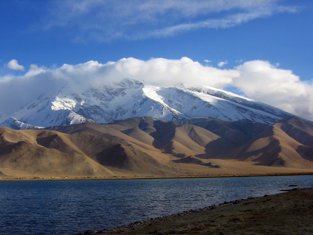
Xinjiang, officially the Xinjiang Uygur Autonomous Region (XUAR), is an autonomous region of the People's Republic of China (PRC), in the northwest of the country at the crossroads of Central Asia and East Asia. The largest province-level division of China by area and the 8th-largest country subdivision in the world, Xinjiang spans over 1.6 million square kilometres (620,000 sq mi) and has about 25 million inhabitants. Xinjiang borders the countries of Afghanistan, India, Kazakhstan, Kyrgyzstan, Mongolia, Pakistan, Russia, and Tajikistan. The rugged Karakoram, Kunlun, and Tian Shan mountain ranges occupy much of Xinjiang's borders, as well as its western and southern regions. The Aksai Chin and Trans-Karakoram Tract regions are claimed by India but administered by China. Xinjiang also borders the Tibet Autonomous Region and the provinces of Gansu and Qinghai. The best-known route of the historic Silk Road ran through the territory from the east to its northwestern border.
High mountain ranges divide Xinjiang into the Dzungarian Basin (Dzungaria) in the north and the Tarim Basin in the south. Only about 9.7% of Xinjiang's land area is fit for human habitation.[unreliable source?] It is home to a number of ethnic groups, including the Han Chinese, Hui, Kazakhs, Kyrgyz, Mongols, Russians, Sibe, Tajiks (Pamiris), Tibetans, and Uyghurs. There are more than a dozen autonomous prefectures and counties for minorities in Xinjiang. Many older English-language reference works call the area Chinese Turkestan, Chinese Turkistan, East Turkestan or East Turkistan.
With a documented history of at least 2,500 years, a succession of people and empires have vied for control over all or parts of this territory. In the 18th century it came under the rule of the Qing dynasty, which was later replaced by the Republic of China. Since 1949 and the Chinese Civil War, it has been part of the People's Republic of China. In 1954, the Chinese Communist Party (CCP) established the Xinjiang Production and Construction Corps (XPCC) to strengthen border defense against the Soviet Union and promote the local economy by settling soldiers into the region. In 1955, Xinjiang was administratively changed from a province into an autonomous region. In recent decades, abundant oil and mineral reserves have been found in Xinjiang and it has become China's largest natural-gas-producing region.
From the 1990s to the 2010s, the East Turkestan independence movement, separatist conflict and the influence of radical Islam have resulted in unrest in the region with occasional terrorist attacks and clashes between separatist and government forces. These conflicts prompted the Chinese government to commit a series of ongoing human rights abuses against Uyghurs and other ethnic and religious minorities in the region including, according to some, genocide.
The general region of Xinjiang has been known by many different names, including Altishahr—the historical Uyghur name for the southern half of the region referring to "the six cities" of the Tarim Basin—Khotan, Khotay, Chinese Tartary, High Tartary, East Chagatay (it was the eastern part of the Chagatai Khanate), Moghulistan ("land of the Mongols"), Kashgaria, Little Bokhara, Serindia (due to Indian cultural influence) and, in Chinese, Xiyu (西域), meaning "Western Regions".
Between the 2nd century BC and 2nd century AD, the Han Empire established the Protectorate of the Western Regions or Xiyu Protectorate (西域都護府) in an effort to secure the profitable routes of the Silk Road. The Western Regions during the Tang era were known as Qixi (磧西). Qi refers to the Gobi Desert and Xi refers to the west. The Tang Empire established the Protectorate General to Pacify the West or Anxi Protectorate (安西都護府) in 640 to control the region.
During the Qing dynasty, the northern part of Xinjiang, Dzungaria, was known as Zhunbu (準部, "Dzungar region") and the Southern Tarim Basin as Huijiang (回疆, "Muslim Frontier"). Both regions merged after the Qing dynasty suppressed the Revolt of the Altishahr Khojas in 1759, becoming "Xiyu Xinjiang" (西域新疆, literally "Western Regions' New Frontier"), later simplified as "Xinjiang" (新疆; formerly romanized as "Sinkiang"). The official name was given during the reign of the Guangxu Emperor in 1878. It can be translated as "new frontier" or "new territory". In fact, the term "Xinjiang" was used in many other places conquered but never ruled by Chinese empires directly until the gradual Gaitu Guiliu administrative reform, including regions in Southern China. For instance, present-day Jinchuan County in Sichuan was then known as "Jinchuan Xinjiang", Zhaotong in Yunnan was named "Xinjiang", Qiandongnan region, Anshun and Zhenning were named "Liangyou Xinjiang", etc.
In 1955, Xinjiang Province was renamed "Xinjiang Uygur Autonomous Region". The name originally proposed was simply "Xinjiang Autonomous Region" because that was the name of the imperial territory. This proposal was not well received by Uyghurs in the Communist Party, who found the name colonialist since it meant "new territory". Seypidin Azizi, the first chairman of Xinjiang, expressed his strong objection to the proposed name to Mao Zedong, arguing that "autonomy is not given to mountains and rivers. It is given to particular nationalities." Some Uyghur Communists proposed the name "Tian Shan Uyghur Autonomous Region" instead. The Han Communists in the central government denied the name Xinjiang was colonialist or that the central government could be colonialist, both because they were communists and because China was a victim of colonialism. But due to the Uyghur complaints, the administrative region was named "Xinjiang Uygur Autonomous Region".
Xinjiang
Xinjiang, officially the Xinjiang Uygur Autonomous Region (XUAR), is an autonomous region of the People's Republic of China (PRC), in the northwest of the country at the crossroads of Central Asia and East Asia. The largest province-level division of China by area and the 8th-largest country subdivision in the world, Xinjiang spans over 1.6 million square kilometres (620,000 sq mi) and has about 25 million inhabitants. Xinjiang borders the countries of Afghanistan, India, Kazakhstan, Kyrgyzstan, Mongolia, Pakistan, Russia, and Tajikistan. The rugged Karakoram, Kunlun, and Tian Shan mountain ranges occupy much of Xinjiang's borders, as well as its western and southern regions. The Aksai Chin and Trans-Karakoram Tract regions are claimed by India but administered by China. Xinjiang also borders the Tibet Autonomous Region and the provinces of Gansu and Qinghai. The best-known route of the historic Silk Road ran through the territory from the east to its northwestern border.
High mountain ranges divide Xinjiang into the Dzungarian Basin (Dzungaria) in the north and the Tarim Basin in the south. Only about 9.7% of Xinjiang's land area is fit for human habitation.[unreliable source?] It is home to a number of ethnic groups, including the Han Chinese, Hui, Kazakhs, Kyrgyz, Mongols, Russians, Sibe, Tajiks (Pamiris), Tibetans, and Uyghurs. There are more than a dozen autonomous prefectures and counties for minorities in Xinjiang. Many older English-language reference works call the area Chinese Turkestan, Chinese Turkistan, East Turkestan or East Turkistan.
With a documented history of at least 2,500 years, a succession of people and empires have vied for control over all or parts of this territory. In the 18th century it came under the rule of the Qing dynasty, which was later replaced by the Republic of China. Since 1949 and the Chinese Civil War, it has been part of the People's Republic of China. In 1954, the Chinese Communist Party (CCP) established the Xinjiang Production and Construction Corps (XPCC) to strengthen border defense against the Soviet Union and promote the local economy by settling soldiers into the region. In 1955, Xinjiang was administratively changed from a province into an autonomous region. In recent decades, abundant oil and mineral reserves have been found in Xinjiang and it has become China's largest natural-gas-producing region.
From the 1990s to the 2010s, the East Turkestan independence movement, separatist conflict and the influence of radical Islam have resulted in unrest in the region with occasional terrorist attacks and clashes between separatist and government forces. These conflicts prompted the Chinese government to commit a series of ongoing human rights abuses against Uyghurs and other ethnic and religious minorities in the region including, according to some, genocide.
The general region of Xinjiang has been known by many different names, including Altishahr—the historical Uyghur name for the southern half of the region referring to "the six cities" of the Tarim Basin—Khotan, Khotay, Chinese Tartary, High Tartary, East Chagatay (it was the eastern part of the Chagatai Khanate), Moghulistan ("land of the Mongols"), Kashgaria, Little Bokhara, Serindia (due to Indian cultural influence) and, in Chinese, Xiyu (西域), meaning "Western Regions".
Between the 2nd century BC and 2nd century AD, the Han Empire established the Protectorate of the Western Regions or Xiyu Protectorate (西域都護府) in an effort to secure the profitable routes of the Silk Road. The Western Regions during the Tang era were known as Qixi (磧西). Qi refers to the Gobi Desert and Xi refers to the west. The Tang Empire established the Protectorate General to Pacify the West or Anxi Protectorate (安西都護府) in 640 to control the region.
During the Qing dynasty, the northern part of Xinjiang, Dzungaria, was known as Zhunbu (準部, "Dzungar region") and the Southern Tarim Basin as Huijiang (回疆, "Muslim Frontier"). Both regions merged after the Qing dynasty suppressed the Revolt of the Altishahr Khojas in 1759, becoming "Xiyu Xinjiang" (西域新疆, literally "Western Regions' New Frontier"), later simplified as "Xinjiang" (新疆; formerly romanized as "Sinkiang"). The official name was given during the reign of the Guangxu Emperor in 1878. It can be translated as "new frontier" or "new territory". In fact, the term "Xinjiang" was used in many other places conquered but never ruled by Chinese empires directly until the gradual Gaitu Guiliu administrative reform, including regions in Southern China. For instance, present-day Jinchuan County in Sichuan was then known as "Jinchuan Xinjiang", Zhaotong in Yunnan was named "Xinjiang", Qiandongnan region, Anshun and Zhenning were named "Liangyou Xinjiang", etc.
In 1955, Xinjiang Province was renamed "Xinjiang Uygur Autonomous Region". The name originally proposed was simply "Xinjiang Autonomous Region" because that was the name of the imperial territory. This proposal was not well received by Uyghurs in the Communist Party, who found the name colonialist since it meant "new territory". Seypidin Azizi, the first chairman of Xinjiang, expressed his strong objection to the proposed name to Mao Zedong, arguing that "autonomy is not given to mountains and rivers. It is given to particular nationalities." Some Uyghur Communists proposed the name "Tian Shan Uyghur Autonomous Region" instead. The Han Communists in the central government denied the name Xinjiang was colonialist or that the central government could be colonialist, both because they were communists and because China was a victim of colonialism. But due to the Uyghur complaints, the administrative region was named "Xinjiang Uygur Autonomous Region".
Recent media
Recent media