
Community hub
Recent from talks
Contribute something
Nothing was collected or created yet.
Zhigulevsk
View on Wikipedia
Zhigulevsk (Russian: Жигулёвск, IPA: [ʐɨɡʊˈlʲɵfsk]) is a town in Samara Oblast, Russia, located on the right bank of the Volga River in the Samara Bend near the Zhiguli Mountains, 92 kilometers (57 mi) west of Samara. The population was 55,565 (2010 census);[2] 48,770 (2002 census);[6] 44,801 (1989 Soviet census).[7]
Key Information

.png)
.png)


Etymology
[edit]The name Zhigulevsk is taken from the Zhiguli Mountains, but they are named for an earlier settlement of Zhigulevka, itself probably named for an early inhabitant, Zhegul (Жегуль).[8]
History
[edit]The town occupies the territories of former villages of Otvazhnoye (Отва́жное, known since 1840) and Morkvashi (Моркваши, known since 1647). The work settlement of Otvazhny (Отва́жный) was built here to develop the oil deposits. In 1949, it was merged with the villages and renamed Zhigulevsk.[citation needed] It was granted town status in 1952.[citation needed]
Besides oil, the town also develops limestone deposits.
Administrative and municipal status
[edit]Within the framework of administrative divisions, it is, together with five rural localities, incorporated as the town of oblast significance of Zhigulevsk—an administrative unit with the status equal to that of the districts.[1] As a municipal division, the town of oblast significance of Zhigulevsk is incorporated as Zhigulevsk urban okrug.[3]
Notable people
[edit]- Alexei Semyonov, ice hockey goaltender
- Diana Shnaider, professional tennis player
References
[edit]- ^ a b c d Charter of Samara Oblast
- ^ a b Russian Federal State Statistics Service (2011). Всероссийская перепись населения 2010 года. Том 1 [2010 All-Russian Population Census, vol. 1]. Всероссийская перепись населения 2010 года [2010 All-Russia Population Census] (in Russian). Federal State Statistics Service.
- ^ a b c Law #189-GD
- ^ "Об исчислении времени". Официальный интернет-портал правовой информации (in Russian). June 3, 2011. Retrieved January 19, 2019.
- ^ Почта России. Информационно-вычислительный центр ОАСУ РПО. (Russian Post). Поиск объектов почтовой связи (Postal Objects Search) (in Russian)
- ^ Federal State Statistics Service (May 21, 2004). Численность населения России, субъектов Российской Федерации в составе федеральных округов, районов, городских поселений, сельских населённых пунктов – районных центров и сельских населённых пунктов с населением 3 тысячи и более человек [Population of Russia, Its Federal Districts, Federal Subjects, Districts, Urban Localities, Rural Localities—Administrative Centers, and Rural Localities with Population of Over 3,000] (XLS). Всероссийская перепись населения 2002 года [All-Russia Population Census of 2002] (in Russian).
- ^ Всесоюзная перепись населения 1989 г. Численность наличного населения союзных и автономных республик, автономных областей и округов, краёв, областей, районов, городских поселений и сёл-райцентров [All Union Population Census of 1989: Present Population of Union and Autonomous Republics, Autonomous Oblasts and Okrugs, Krais, Oblasts, Districts, Urban Settlements, and Villages Serving as District Administrative Centers]. Всесоюзная перепись населения 1989 года [All-Union Population Census of 1989] (in Russian). Институт демографии Национального исследовательского университета: Высшая школа экономики [Institute of Demography at the National Research University: Higher School of Economics]. 1989 – via Demoscope Weekly.
- ^ Е. М. Поспелов. "Географические названия мира" (Москва, 1998), p. 155.
Further reading
[edit]- Самарская Губернская Дума. №179-ГД 18 декабря 2006 г. «Устав Самарской области», в ред. Закона №6-ГД от 11 января 2016 г. «О внесении изменений в Устав Самарской области». Вступил в силу 1 января 2007 г. Опубликован: "Волжская коммуна", №237 (25790), 20 декабря 2006 г. (Samara Governorate Duma. #179-GD December 18, 2006 Charter of Samara Oblast, as amended by the Law #6-GD of January 11, 2016 On Amending the Charter of Samara Oblast. Effective as of January 1, 2007.).
- Самарская Губернская Дума. Закон №189-ГД от 28 декабря 2004 г. «О наделении статусом городского округа и муниципального района муниципальных образований в Самарской области», в ред. Закона №23-ГД от 30 марта 2015 г. «Об осуществлении местного самоуправления на территории городского округа Самара Самарской области». Вступил в силу по истечении десяти дней со дня официального опубликования. Опубликован: "Волжская коммуна", №247, 31 декабря 2004 г. (Samara Governorate Duma. Law #189-GD of December 28, 2004 On Granting the Status of Urban Okrug and Municipal District to the Municipal Formations in Samara Oblast, as amended by the Law #23-GD of March 30, 2015 On the Implementation of Local Self-Government on the Territory of Samara Urban Okrug of Samara Oblast. Effective as of after ten days from the day of the official publication.).
External links
[edit]![]() Media related to Zhigulyovsk at Wikimedia Commons
Media related to Zhigulyovsk at Wikimedia Commons
- Official website of Zhigulevsk (in Russian)
- Zhigulyovsk Business Directory (in Russian)
Zhigulevsk
View on GrokipediaGeography and Environment
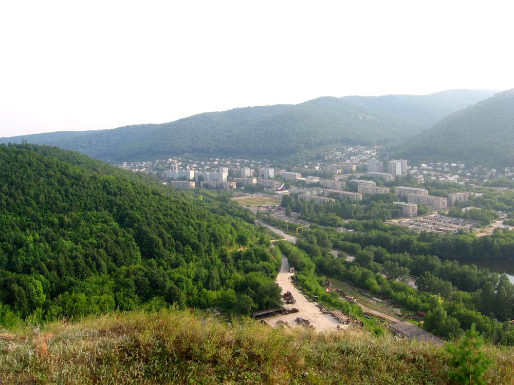
Location and Topography
Zhigulevsk is situated at geographic coordinates 53°23′59″N 49°29′43″E.[1] The city lies on the right bank of the Volga River within the Samara Bend, a prominent meander formed by the river's course around the Zhiguli Mountains, approximately 92 kilometers west of the regional center of Samara. This positioning places Zhigulevsk at the eastern edge of the Samarskaya Luka peninsula, where the Volga creates a natural boundary and scenic backdrop.[12] The city's elevation averages 70 meters above sea level, reflecting its low-lying position along the river floodplain while rising gradually toward the adjacent uplands.[13] Immediately to the west and south, the Zhiguli Mountains dominate the local topography, forming a rugged chain of hills with steep slopes and plateaus that extend parallel to the Volga. These mountains, reaching heights up to 375 meters, are characterized by exposed limestone and dolomite formations dating to the Permian period, which contribute to the area's karst features, cliffs, and distinctive relief.[12] The limestone deposits not only shape the dramatic skyline but also influence soil composition and vegetation patterns in the surrounding terrain. The urban layout of Zhigulevsk has developed in close adaptation to this riverine and mountainous setting, with residential and industrial zones primarily aligned along the Volga's shoreline for access to water transport and resources. Early settlement patterns followed the relatively flat riverbank terraces, while later expansions navigated the rising slopes toward the mountain foothills, incorporating the natural contours to minimize erosion and integrate with the landscape. This topography has constrained linear growth along the river, fostering a compact urban form that borders the Samarskaya Luka National Park to the west.[2]Climate
Zhigulevsk experiences a humid continental climate classified as Dfb under the Köppen system, characterized by cold, snowy winters and warm, relatively short summers.[1] This classification reflects the region's continental location, with significant temperature variations between seasons and no prolonged dry period. Winters are dominated by subfreezing temperatures, while summers bring mild to warm conditions conducive to outdoor activities. Average monthly temperatures illustrate the seasonal extremes: in January, the mean low reaches -14°C, with highs around -8°C, while July sees average highs of 26°C and lows of 16°C.[14] Annual precipitation totals approximately 500-600 mm, distributed fairly evenly but peaking in summer months like June, which contributes to lush vegetation along the riverbanks during warmer periods.[15] The proximity of the Volga River and the surrounding Zhiguli Mountains creates distinct microclimates in Zhigulevsk, moderating temperatures slightly compared to inland areas and fostering frequent fog in autumn and winter due to the river's influence, as well as variable wind patterns channeled through the mountainous terrain.[13] Recorded temperature extremes include lows rarely dropping below -26°C and highs seldom exceeding 32°C, underscoring the harsh winter potential.[13] Climate trends in the Volga Federal District from 1966 to 2021 indicate a warming pattern, with annual average air temperatures increasing by 0.27–0.53 °C per decade.[16]History
Early Settlement
The area encompassing modern Zhigulevsk, part of the Samara Bend region, has evidence of early human activity tied to indigenous and medieval cultures. Archaeological findings in the vicinity of Morkvashi reveal traces of Volga Bulgar culture dating to the 10th–13th centuries, indicating settlement and economic activity by this Turkic-speaking people who established a trading hub along the Volga River.[17] The Samara Bend served as a strategic location for ancient trade routes, where Arab and Persian merchants transported goods to the Bulgar Kingdom, including furs, honey, and slaves destined for the Caspian Sea markets. Additionally, the region's dense forests and rugged terrain provided refuge for indigenous Finno-Ugric groups and later for runaway serfs and rebels, such as those during the uprisings led by Stenka Razin in the 17th century and Yemelyan Pugachev in the 18th century.[18] The earliest documented settlements in the area were the villages of Morkvashi and Otvazhnoye, which formed the pre-industrial core of what became Zhigulevsk. Morkvashi was first recorded in the 1647 census as a small hamlet owned by landlord Vasily Poretsky, comprising just two households and likely originating from earlier Bulgar-era inhabitants who engaged in basic farming and river-based livelihoods.[17] By the late 17th century, it had passed to the Bronsky noble family and later to Count Vladimir Grigoryevich Orlov in the early 18th century, reflecting the feudal land allocations common in the Middle Volga region.[18] Otvazhnoye emerged later, established in 1840 when Count Vladimir Petrovich Orlov-Davydov resettled about 30 serf families from his estates to clear land at the foot of the Mogutovaya and Shishka mountains; initial dwellings were rudimentary, with settlers living in a single wooden barrack in what is now the nearby village of Zol'noye.[19] The name Otvazhnoye derives either from the surname of the first village elder, a Ukrainian named Otvazhnenko, or from the perceived bravery of these pioneers in taming the forested wilderness. The name Zhigulevsk itself stems from the surrounding Zhiguli Mountains, which were named after the earlier settlement of Zhigulevka (also known as Zhegulevka or Zhegulikha), founded around 1660 and possibly derived from a resident named Semyon Grigoryevich Zhegul, a settler from Veliky Ustyug.[20] Prior to the 20th century, the local economy revolved around subsistence agriculture, with villagers in Morkvashi and Otvazhnoye cultivating fields like the Alexandrovskoye for grains and vegetables, while the Volga facilitated seasonal trade in timber, fish, and agricultural surplus to nearby towns such as Syzran. Forests in the Zhiguli were exploited for logging under noble oversight, with wood floated down the river or transported via early narrow-gauge railways built by landowners like Orlov-Davydov to support regional commerce.[19] This agrarian focus persisted until industrial shifts, underscoring the area's role as a peripheral outpost in the Volga trade network.Industrial Development and Modern Era
Zhigulevsk was founded in 1949 through the merger of the villages of Otvazhnoye and Morkvashi with the workers' settlement of Otvazhny as part of the preparations for constructing the Kuybyshev Hydroelectric Power Station, incorporating ongoing oil exploration activities in the region that dated back to the early 1940s.[21][22] The integration aimed to centralize operations for the major engineering project while supporting resource extraction, transforming the area from rural settlements into an industrial hub.[23] In 1952, the workers' settlement achieved town status via a decree from the Presidium of the Supreme Soviet of the RSFSR on February 21, formalizing its role as an administrative center.[21] Concurrently, the development of limestone quarries accelerated to supply construction materials for the nearby Kuibyshev Hydroelectric Power Station; three key quarries were established for open-pit mining of high-purity Zhiguli limestone, supporting cement production and infrastructure builds.[24] During the Soviet era, these industries expanded significantly, with oil extraction scaling up through state investments and the construction materials sector growing to provide aggregates for regional hydropower and urban development, leading to population influx and foundational infrastructure like housing and factories by the 1970s.[25] Following the dissolution of the Soviet Union in 1991, Zhigulevsk underwent economic transitions from state-dominated oil and materials production to a more diversified model, incorporating private enterprises and tourism potential tied to the Samarskaya Luka National Park.[26] Challenges included privatization of quarries and oil assets, but by the 2000s, stabilization occurred with ongoing operations at the Zhigulevsky Limestone Plant and energy sector ties.[27] Developments in the mid-2010s emphasized infrastructure renewal, such as road repairs exceeding 200 million rubles since 2014, reconstruction of the Kristall Stadium in 2014, and the Atlant sports complex reopening in 2015, alongside strategic plans for socio-economic growth through 2030 focusing on tourism and small business support.[21][28]Government and Administration
Administrative Status
Zhigulevsk holds the status of a town of oblast significance in Samara Oblast, a federal subject of the Russian Federation within the Volga Federal District.[29] As a municipal division, the town is incorporated as the Zhigulevsk Urban Okrug, an administrative-territorial unit that includes the town itself and the subordinate rural localities of Shiryaevo, Bakhlova Polyana, Zolnoe, Bogatyr, and Solnechnaya Polyana. The boundaries of the urban okrug are defined by the Samara Oblast Law on Administrative-Territorial Structure, encompassing an area of 94.15 square kilometers along the right bank of the Volga River.[30] The postal code assigned to Zhigulevsk is 445350, and the town observes the UTC+4 time zone (MSK+1), consistent with Samara Oblast.[29][31] This administrative framework has remained stable as of 2025, with no reported reforms altering the town's oblast significance or urban okrug incorporation since the initial granting of town status in 1952.[29]Local Governance
Zhigulevsk operates as an urban okrug, with its local governance structured around a representative legislative body and an executive administration. The City Duma (Дума городского округа Жигулевск) serves as the primary representative organ, consisting of elected deputies who oversee legislative functions and approve key administrative decisions.[32] The Duma is elected by direct popular vote every five years, with the most recent election occurring in September 2025, resulting in a new convocation that retained 14 deputies from the previous term.[33] The executive branch is led by the Head of the Urban Okrug, who is appointed by the City Duma following a competitive selection process among finalists. As of November 2025, the Head is Alexey Nikolaevich Ivanov, elected unanimously by the Duma on October 15, 2025, succeeding Ilya Sukhikh.[34] Ivanov, who had served as interim head, was selected from a shortlist that included deputy head Alexander Katkov.[35] The Duma, chaired by Elena Rebrova in its current convocation, holds sessions to deliberate and vote on such appointments.[36] The administration, operating under the Head's leadership, holds primary responsibility for executive functions as outlined in the Urban Okrug Charter. Key duties include preparing, executing, and reporting on the local budget to ensure fiscal management and resource allocation for municipal needs.[37] It also oversees urban planning, coordinating land use, construction regulations, and infrastructure development to support sustainable growth. Additionally, the administration supervises public services, encompassing housing maintenance, utility provision, social welfare programs, and public order enforcement.[37] Residents and stakeholders can engage with local governance through the official website at zhigulevsk.org, which provides access to documents, news, and online services. Contact mechanisms include the administration's central office at 445350, Zhigulevsk, Pushkina Street 17; telephone 8 (84862) 2-45-43; fax 8 (84862) 7-91-80; and email [email protected].[29]Demographics
Population Trends
The population of Zhigulevsk experienced steady growth from the late Soviet era through the early 2000s, peaking in the 2010 census before entering a period of decline amid broader post-Soviet economic shifts. According to official census data from Rosstat, the town recorded 44,801 residents in 1989, rising to 48,770 by 2002—a roughly 9% increase over 13 years driven by industrial expansion. This upward trend continued, with the 2010 census showing 55,565 inhabitants, marking the highest recorded figure and reflecting influxes tied to local employment opportunities.[38] Subsequent years saw a reversal, with the 2021 census reporting 50,466 residents, a 9.1% drop from 2010. Recent estimates indicate further reduction, projecting 48,070 by January 1, 2025, at an annual decline rate of about 1.5%. This contraction aligns with national patterns in mono-industrial towns, where out-migration exceeds natural growth due to limited diversification.[39][38]| Year | Population | Change from Previous (%) | Source |
|---|---|---|---|
| 1989 | 44,801 | - | Rosstat (Soviet Census)[38] |
| 2002 | 48,770 | +8.9 | Rosstat Census[38] |
| 2010 | 55,565 | +13.9 | Rosstat Census[38] |
| 2021 | 50,466 | -9.1 | Rosstat Census[38] |
| 2025 (est.) | 48,070 | -4.8 (from 2021) | Rosstat via City Population[39] |