Recent from talks
Canadian Shield
Knowledge base stats:
Talk channels stats:
Members stats:
Canadian Shield
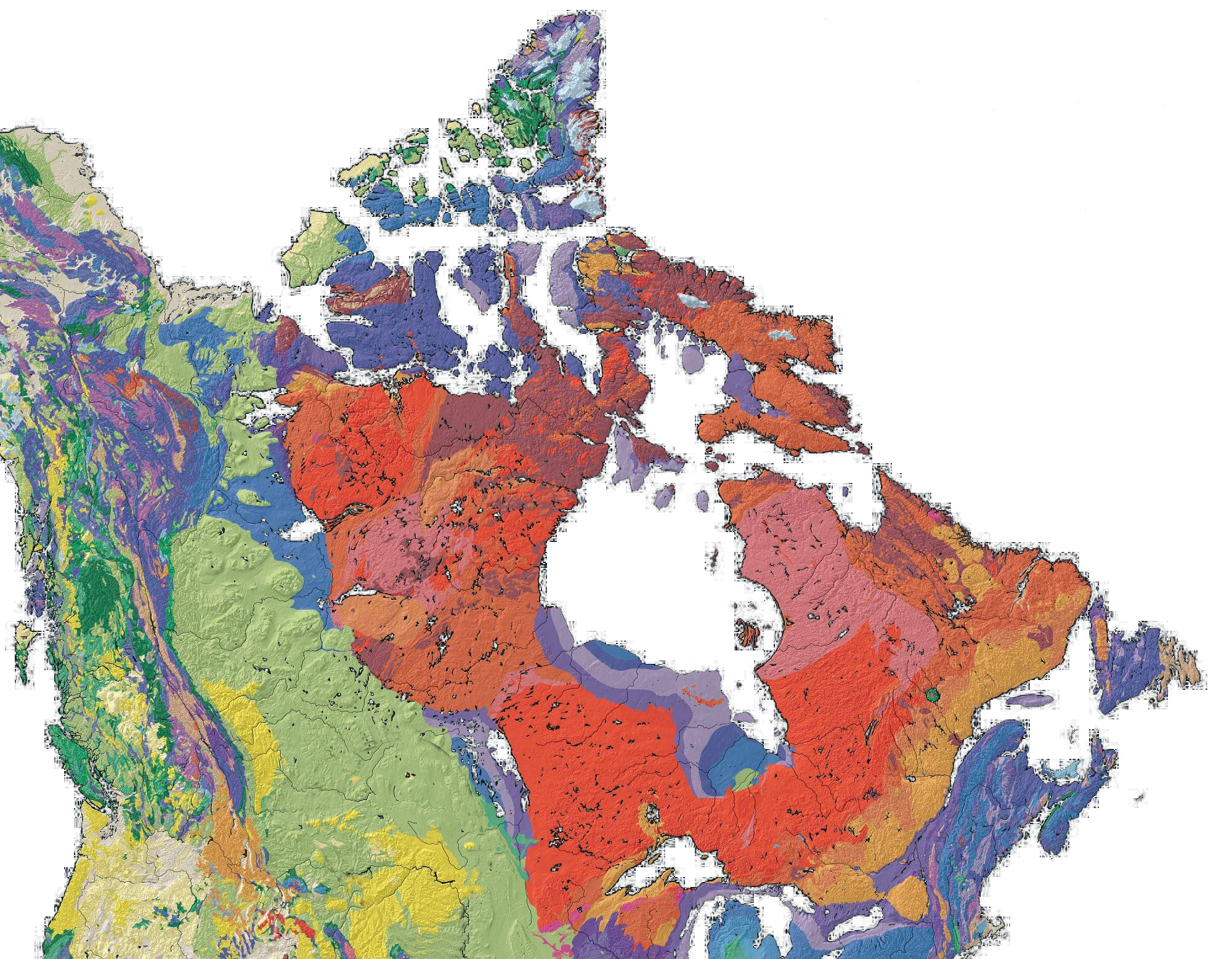
The Canadian Shield (French: Bouclier canadien [buklje kanadjɛ̃]), also called the Laurentian Shield or the Laurentian Plateau, is a geologic shield, a large area of exposed Precambrian igneous and high-grade metamorphic rocks. It forms the North American Craton (or Laurentia), the ancient geologic core of the North American continent. Glaciation has left the area with only a thin layer of soil, through which exposures of igneous bedrock resulting from its long volcanic history are frequently visible. As a deep, common, joined bedrock region in eastern and central Canada, the shield stretches north from the Great Lakes to the Arctic Ocean, covering over half of Canada and most of Greenland; it also extends south into the northern reaches of the continental United States.
The Canadian Shield is a physiographic division comprising four smaller physiographic provinces: the Laurentian Upland, Kazan Region, Davis and James. The shield extends into the United States as the Adirondack Mountains (connected by the Frontenac Axis) and the Superior Upland. The Canadian Shield is a U-shaped subsection of the Laurentia craton signifying the area of greatest glacial impact (scraping down to bare rock) creating the thin soils. The age of the Canadian Shield is estimated to be 4.28 Ga (4.28 billion years). The Canadian Shield once had jagged peaks, higher than any of today's mountains, but millions of years of erosion have transformed these mountains to rolling hills.
The Canadian Shield is a collage of Archean plates and accreted juvenile arc terranes and sedimentary basins of the Proterozoic Eon that were progressively amalgamated during the interval 2.45–1.24 Ga, with the most substantial growth period occurring during the Trans-Hudson orogeny, between c. 1.90–1.80 Ga. The Canadian Shield was the first part of North America to be permanently elevated above sea level and has remained almost wholly untouched by successive encroachments of the sea upon the continent. It is the Earth's greatest area of exposed Archean rock. The metamorphic base rocks are mostly from the Precambrian (between 4.5 Ga and 540 Ma) and have been repeatedly uplifted and eroded. Today it consists largely of an area of low relief 300–610 m (980–2,000 ft) above sea level with a few monadnocks and low mountain ranges (including the Laurentian Mountains) probably eroded from the plateau during the Cenozoic Era. During the Pleistocene Epoch, continental ice sheets depressed the land surface (creating Hudson Bay) but also tilted up its northeastern "rim" (the Torngat), scooped out thousands of lake basins, and carried away much of the region's soil. The northeastern portion, however, became tilted up so that, in northern Labrador and Baffin Island, the land rises to more than 1,500 metres (5,000 feet) above sea level.
When the Greenland section is included, the Canadian Shield is approximately circular, bounded on the northeast by the northeast edge of Greenland, with Hudson Bay in the middle. It covers much of Greenland, all of Labrador and the Great Northern Peninsula of Newfoundland, most of Quebec north of the St. Lawrence River, much of Ontario including northern sections of the Ontario Peninsula, the Adirondack Mountains of New York, the northernmost part of Lower Michigan and all of Upper Michigan, northern Wisconsin, northeastern Minnesota, the central and northern portions of Manitoba, northern Saskatchewan, a small portion of northeastern Alberta, mainland Northwest Territories to the east of a line extended north from the Saskatchewan-Alberta border, most of Nunavut's mainland and, of its Arctic Archipelago, Baffin Island and significant bands through Somerset, Southampton, Devon and Ellesmere islands. In total, the exposed area of the shield covers approximately 8,000,000 km2 (3,100,000 sq mi). The true extent of the shield is greater still and stretches from the Western Cordillera in the west to the Appalachians in the east and as far south as Texas, but these regions are overlaid with much younger rocks and sediment.
The Canadian Shield is among the oldest geologic areas on Earth, with regions dating from 2.5 to 4.2 billion years. The multitude of rivers and lakes in the region is classical example of a deranged drainage system, caused by the watersheds of the area being disturbed by glaciation and the effect of post-glacial rebound. The shield was originally an area of very large, very tall mountains (about 12,000 m or 39,000 ft) with much volcanic activity, but the area was eroded to nearly its current topographic appearance of relatively low relief over 500 Ma. Erosion has exposed the roots of the mountains, which take the form of greenstone belts in which belts of volcanic rock that have been altered by metamorphism are surrounded by granitic rock. These belts range in age from 3.6 to 2.7 Ga. Much of the granitic rock belongs to the distinctive tonalite–trondhjemite–granodiorite family of rocks, which are characteristic of Archean continental crust. Many of Canada's major ore deposits are associated with greenstone belts.
The Sturgeon Lake Caldera in Kenora District, Ontario, is one of the world's best preserved mineralized Neoarchean caldera complexes, which is 2.7 Ga. The Canadian Shield also contains the Mackenzie dike swarm, which is the largest dike swarm known on Earth. The North American craton is the bedrock forming the heart of the North American continent, and the Canadian Shield is the largest exposed part of the craton's bedrock. The Canadian Shield is part of an ancient continent called Arctica, which was formed about 2.5 Ga during the Neoarchean era.
Mountains have deep roots and float on the denser mantle much like an iceberg at sea. As mountains erode, their roots rise and are eroded in turn. The rocks that now form the surface of the shield were once far below the Earth's surface. The high pressures and temperatures at those depths provided ideal conditions for mineralization. Although these mountains are now heavily eroded, many large mountains still exist in Canada's far north called the Arctic Cordillera. This is a vast, deeply dissected mountain range, stretching from northernmost Ellesmere Island to the northernmost tip of Labrador. The range's highest peak is Nunavut's Barbeau Peak at 2,616 metres (8,583 ft) above sea level. Precambrian rock is the major component of the bedrock.
The current surface expression of the shield is one of very thin soil lying on top of the bedrock, with many bare outcrops. This arrangement was caused by severe glaciation during the ice ages that covered the shield and scraped the rock clean. The lowlands of the Canadian Shield have a very dense soil that is not suitable for forestation; it also contains many marshes and bogs (muskegs). The rest of the region has coarse soil that does not retain moisture well and is frozen with permafrost throughout the year. Forests are not as dense in the north.
Hub AI
Canadian Shield AI simulator
(@Canadian Shield_simulator)
Canadian Shield
The Canadian Shield (French: Bouclier canadien [buklje kanadjɛ̃]), also called the Laurentian Shield or the Laurentian Plateau, is a geologic shield, a large area of exposed Precambrian igneous and high-grade metamorphic rocks. It forms the North American Craton (or Laurentia), the ancient geologic core of the North American continent. Glaciation has left the area with only a thin layer of soil, through which exposures of igneous bedrock resulting from its long volcanic history are frequently visible. As a deep, common, joined bedrock region in eastern and central Canada, the shield stretches north from the Great Lakes to the Arctic Ocean, covering over half of Canada and most of Greenland; it also extends south into the northern reaches of the continental United States.
The Canadian Shield is a physiographic division comprising four smaller physiographic provinces: the Laurentian Upland, Kazan Region, Davis and James. The shield extends into the United States as the Adirondack Mountains (connected by the Frontenac Axis) and the Superior Upland. The Canadian Shield is a U-shaped subsection of the Laurentia craton signifying the area of greatest glacial impact (scraping down to bare rock) creating the thin soils. The age of the Canadian Shield is estimated to be 4.28 Ga (4.28 billion years). The Canadian Shield once had jagged peaks, higher than any of today's mountains, but millions of years of erosion have transformed these mountains to rolling hills.
The Canadian Shield is a collage of Archean plates and accreted juvenile arc terranes and sedimentary basins of the Proterozoic Eon that were progressively amalgamated during the interval 2.45–1.24 Ga, with the most substantial growth period occurring during the Trans-Hudson orogeny, between c. 1.90–1.80 Ga. The Canadian Shield was the first part of North America to be permanently elevated above sea level and has remained almost wholly untouched by successive encroachments of the sea upon the continent. It is the Earth's greatest area of exposed Archean rock. The metamorphic base rocks are mostly from the Precambrian (between 4.5 Ga and 540 Ma) and have been repeatedly uplifted and eroded. Today it consists largely of an area of low relief 300–610 m (980–2,000 ft) above sea level with a few monadnocks and low mountain ranges (including the Laurentian Mountains) probably eroded from the plateau during the Cenozoic Era. During the Pleistocene Epoch, continental ice sheets depressed the land surface (creating Hudson Bay) but also tilted up its northeastern "rim" (the Torngat), scooped out thousands of lake basins, and carried away much of the region's soil. The northeastern portion, however, became tilted up so that, in northern Labrador and Baffin Island, the land rises to more than 1,500 metres (5,000 feet) above sea level.
When the Greenland section is included, the Canadian Shield is approximately circular, bounded on the northeast by the northeast edge of Greenland, with Hudson Bay in the middle. It covers much of Greenland, all of Labrador and the Great Northern Peninsula of Newfoundland, most of Quebec north of the St. Lawrence River, much of Ontario including northern sections of the Ontario Peninsula, the Adirondack Mountains of New York, the northernmost part of Lower Michigan and all of Upper Michigan, northern Wisconsin, northeastern Minnesota, the central and northern portions of Manitoba, northern Saskatchewan, a small portion of northeastern Alberta, mainland Northwest Territories to the east of a line extended north from the Saskatchewan-Alberta border, most of Nunavut's mainland and, of its Arctic Archipelago, Baffin Island and significant bands through Somerset, Southampton, Devon and Ellesmere islands. In total, the exposed area of the shield covers approximately 8,000,000 km2 (3,100,000 sq mi). The true extent of the shield is greater still and stretches from the Western Cordillera in the west to the Appalachians in the east and as far south as Texas, but these regions are overlaid with much younger rocks and sediment.
The Canadian Shield is among the oldest geologic areas on Earth, with regions dating from 2.5 to 4.2 billion years. The multitude of rivers and lakes in the region is classical example of a deranged drainage system, caused by the watersheds of the area being disturbed by glaciation and the effect of post-glacial rebound. The shield was originally an area of very large, very tall mountains (about 12,000 m or 39,000 ft) with much volcanic activity, but the area was eroded to nearly its current topographic appearance of relatively low relief over 500 Ma. Erosion has exposed the roots of the mountains, which take the form of greenstone belts in which belts of volcanic rock that have been altered by metamorphism are surrounded by granitic rock. These belts range in age from 3.6 to 2.7 Ga. Much of the granitic rock belongs to the distinctive tonalite–trondhjemite–granodiorite family of rocks, which are characteristic of Archean continental crust. Many of Canada's major ore deposits are associated with greenstone belts.
The Sturgeon Lake Caldera in Kenora District, Ontario, is one of the world's best preserved mineralized Neoarchean caldera complexes, which is 2.7 Ga. The Canadian Shield also contains the Mackenzie dike swarm, which is the largest dike swarm known on Earth. The North American craton is the bedrock forming the heart of the North American continent, and the Canadian Shield is the largest exposed part of the craton's bedrock. The Canadian Shield is part of an ancient continent called Arctica, which was formed about 2.5 Ga during the Neoarchean era.
Mountains have deep roots and float on the denser mantle much like an iceberg at sea. As mountains erode, their roots rise and are eroded in turn. The rocks that now form the surface of the shield were once far below the Earth's surface. The high pressures and temperatures at those depths provided ideal conditions for mineralization. Although these mountains are now heavily eroded, many large mountains still exist in Canada's far north called the Arctic Cordillera. This is a vast, deeply dissected mountain range, stretching from northernmost Ellesmere Island to the northernmost tip of Labrador. The range's highest peak is Nunavut's Barbeau Peak at 2,616 metres (8,583 ft) above sea level. Precambrian rock is the major component of the bedrock.
The current surface expression of the shield is one of very thin soil lying on top of the bedrock, with many bare outcrops. This arrangement was caused by severe glaciation during the ice ages that covered the shield and scraped the rock clean. The lowlands of the Canadian Shield have a very dense soil that is not suitable for forestation; it also contains many marshes and bogs (muskegs). The rest of the region has coarse soil that does not retain moisture well and is frozen with permafrost throughout the year. Forests are not as dense in the north.
Recent media