
Community hub
Recent from talks
Contribute something
Nothing was collected or created yet.
Citadella
View on WikipediaYou can help expand this article with text translated from the corresponding article in Hungarian. (December 2015) Click [show] for important translation instructions.
|


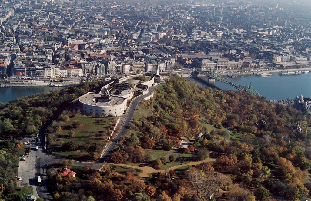
The Citadella (Hungarian pronunciation: [ˈt͡sitɒdɛlːa]) is the fortification located upon the top of Gellért Hill in Budapest, Hungary. Citadella is the Hungarian word for citadel, a kind of fortress. The word is exclusively used by other languages to refer to the Gellért Hill citadel which occupies a place which held strategic importance in Budapest's military history.
History
[edit]The fortress was built in 1851 by Julius Jacob von Haynau, a commander of the Austrian Empire, and was designed by Emmanuel Zitta and Ferenc Kasselik, after the Hungarian Revolution of 1848. It occupies almost the entire 235 metres high plateau. The fortress is a U-shaped structure built about a central courtyard, being 220 metres long, 60 metres wide, and 4 metres tall. It had a complement of sixty cannons.[1]
Actually built by Hungarian forced labourers, it was finished in 1854. In June 1854 Austrian troops settled in the citadel. After the Austro-Hungarian Compromise of 1867 and the establishment of Austria-Hungary, the Hungarians demanded the destruction of the Citadel, but the garrison troops left only in 1897, when the main gate was symbolically damaged. It was not until late 1899 when the city took possession of the Citadel. A few months later, in 1900, the walls were demolished.
In the Hungarian Revolution of 1956, Soviet troops occupied the Citadella and fired down into the city during the assault that overthrew the Nagy-led Hungarian government.
Sights
[edit]
Next to the Danube-facing longitudinal wall of the Citadella, there is an open-air display of a small collection of Red Army weaponry, most of them from the Second World War. The pieces are the following (going left to right on the picture):
- a 76 mm M1942 divisional gun (ZiS-3), a design from 1942
- a 57 mm M1943 anti-tank gun (ZiS-2), a design from 1943
- an 82 mm BM-37 infantry mortar, a design from 1937
- an 85 mm D-44 divisional gun, a design from 1944
- a 57 mm AZP S-60 anti-aircraft autocannon, a design from 1950
From the top of the Citadel, a panoramic view is available of the city, the Danube and its eight bridges. At the east end of the complex is the Liberty Statue.
References
[edit]- ^ "Citadella, Budapest". Archived from the original on 2 October 2011.
| Cultural |
|  |
|---|---|---|
| Natural | ||
| Geographic | |
|---|---|
| Other | |
47°29′13″N 19°02′47″E / 47.48694°N 19.04639°E
This Budapest location article is a stub. You can help Wikipedia by adding missing information. |
This article about a Hungarian building or structure is a stub. You can help Wikipedia by adding missing information. |
Citadella
View on GrokipediaGeography
Location and Physical Features
The Citadella is positioned on the summit of Gellért Hill in Budapest's 11th district, Hungary, on the Buda side of the Danube River, at an elevation of 235 meters above sea level.[8][9] This location affords expansive panoramic views across the city, including both Buda and Pest districts.[10] The fortress features a U-shaped design, extending approximately 220 meters in length and 45-60 meters in width, with limestone walls varying in height from 12 to 16 meters.[11] Its structure includes bastions and defensive elements typical of 19th-century military architecture, originally intended to house artillery and troops.[2] The surrounding terrain consists of wooded slopes and parkland, integrating the site into Gellért Hill's natural landscape.[11]Climate and Environment
Gellért Hill, the site of Citadella in Budapest, Hungary, lies within a humid continental climate zone featuring distinct seasonal variations, with warm to hot summers and cold winters. The average annual temperature is approximately 11.1 °C (52.0 °F), with monthly averages ranging from about -0.5 °C (31.1 °F) in January to 21.5 °C (70.7 °F) in July.[12] Extreme temperatures occasionally drop below -10 °C (14 °F) in winter or exceed 30 °C (86 °F) in summer, though rarely surpassing 33 °C (91.4 °F). Annual precipitation totals around 550-660 mm (21.7-26.0 inches), distributed relatively evenly but with peaks in early summer (May-June) and late autumn, often in the form of thunderstorms; snowfall occurs from December to March, averaging 20-30 cm (8-12 inches) depth during peak winter periods.[13] [14] [12] The hill's elevated position at 235 meters (771 feet) above sea level creates a slightly cooler microclimate compared to the surrounding plains, with increased exposure to winds from the Danube Valley. Relative humidity averages 70-80% year-round, higher in winter, contributing to foggy conditions in the cooler months.[13] These patterns align with broader Central European trends, influenced by continental air masses and proximity to the Carpathian Basin, though urban heat island effects in Budapest moderately elevate local temperatures by 1-2 °C. Environmentally, Gellért Hill functions as a semi-natural urban oasis amid Budapest's built landscape, characterized by dolomite rock outcrops, mixed deciduous forests, and grasslands supporting diverse flora adapted to calcareous soils. Rare wildflower species thrive due to the hill's geology and milder microclimate, including endemics like certain orchids and steppe plants, alongside common trees such as oaks, beeches, and hornbeams.[15] Fauna encompasses urban-adapted species like squirrels, birds (e.g., kestrels, woodpeckers), and small mammals, with the area contributing to Budapest's overall biodiversity of over 900 vascular plant taxa and numerous vertebrates.[16] Designated a protected natural area since 1997 under the management of Duna-Ipoly National Park, the hill preserves these habitats despite urban pressures, including trail erosion and invasive species, while offering panoramic views over the Danube and serving as a key green lung for the city.[9] Archaeological layers beneath the vegetation reveal prehistoric human impacts, but current conservation focuses on maintaining ecological balance without formal UNESCO natural designation, though integrated into Budapest's cultural heritage landscape.[17]History
Foundation and Early Medieval Development
The site of the Citadella on Gellért Hill witnessed early medieval activity tied to the consolidation of Magyar settlement in the Carpathian Basin following their conquest around 895 AD, when the region transitioned from Avar and Slavic influences to Hungarian dominance. The hill, offering elevated oversight of the Danube River and nascent settlements on the Buda and Pest plains, bore early recorded names such as Kelen-hegy (Kelen Hill) and Pesti-hegy (Pest Hill), indicating its role in the emerging landscape of the Kelen district south of Buda.[9][18] Sparse habitation occurred around the hill, with archaeological indications of continuity from prehistoric and Roman eras into this period, though no substantial fortifications existed; the nearby Kelenföld area began forming as a rudimentary village amid broader medieval rural development in the Tabán region.[19] A pivotal event shaping the hill's historical identity was the martyrdom of Bishop Gellért (Gerard of Csanád), an Italian-born cleric and educator to Prince Emeric, son of King Stephen I. On September 24, 1046, during the Vata pagan uprising against Christian king Peter Orseolo—sparked by resistance to forced conversions and royal policies—Gellért and companions Bystrik and Buldus were seized near Pest. Pagans exacted vengeance by enclosing the bishop in a barrel studded with nails and rolling it down the hill's slope, an execution method symbolizing rejection of Christianity.[20][21] This incident, drawn from hagiographical legends compiled near the time of his canonization in the 11th-12th centuries, underscored tensions in Hungary's early Christianization, though accounts blend factual revolt details with pious embellishments; the uprising ultimately failed, reinforcing royal authority.[22] The martyrdom cemented the hill's association with Gellért, evolving into its modern name by the 15th century, despite earlier designations persisting. No evidence indicates organized defensive structures atop the hill in this era, distinguishing it from later fortifications; instead, its prominence lay in symbolic and topographical value amid Hungary's feudal consolidation under the Árpád dynasty. Thermal springs at the hill's base, known since antiquity, likely supported limited monastic or hermit activity, foreshadowing medieval religious uses, though primary development remained agrarian and peripheral to Buda's core.[20][9]Conflicts and Rule Under Local Powers
Cittadella was established in 1220 by the Paduan commune as a fortified outpost in the central Venetian plain, strategically positioned to counter expansionist threats from the rival cities of Vicenza and Treviso amid ongoing territorial disputes in the Veneto region. The site's selection reflected Padua's broader policy of controlling local lords and securing the countryside during the 12th and 13th centuries' interurban conflicts, where city-states vied for dominance through military outposts and alliances.[23][24] From 1237 to 1256, control shifted to Ezzelino III da Romano, a Ghibelline podestà and imperial ally who conquered the town and imposed a harsh tyranny characterized by imprisonment and suppression of local resistance. In 1251, Ezzelino constructed the Torre di Malta within the walls as a prison for political enemies, underscoring his repressive governance, which extended over parts of Padua, Vicenza, and Verona until his broader defeat in 1259. Following his downfall, Cittadella reverted to Paduan authority, though the town remained a flashpoint in regional power struggles.[23][24][25] In the early 14th century, the town experienced further transitions under local dynasties, passing briefly in 1318 to Cangrande I della Scala of Verona before returning to Paduan rule under the Da Carrara family, who fortified it as a key stronghold against neighboring aggressions. The Da Carrara lords maintained control through much of the 1300s, leveraging Cittadella's defenses in the persistent rivalries among Veneto's signorie, including skirmishes tied to imperial and papal factions. This era of fragmented lordship ended with the consolidation of Venetian influence, as the town's strategic value drew it into the Republic's orbit by 1406.[25][26]Venetian Republic and Later Periods
In 1405, following the conquest of Padua, Cittadella voluntarily submitted to the Republic of Venice, transitioning from Carraresi rule to Venetian dominion alongside much of the Veneto mainland.[27] This integration marked the start of approximately 392 years of stable governance under Venice, during which the town served as a fortified outpost in the terraferma territories, benefiting from the Republic's emphasis on defensive infrastructure and agricultural prosperity in the Po Valley plain.[28] Venetian administrators, often appointed as podestà, oversaw local affairs, with symbolic additions like the Lion of Saint Mark emblem reinforcing loyalty to the Serenissima.[27] The period under Venetian rule saw limited major conflicts within the town itself, though it contributed to broader Republican efforts, such as during the War of the League of Cambrai (1508–1516), where Veneto strongholds like Cittadella helped repel French and imperial incursions.[29] Economically, the town's chessboard street layout and encircling walls—originally Paduan constructions from 1220—were maintained and adapted for Venetian military needs, supporting trade in grain, wine, and textiles while fostering modest population growth amid the Republic's mercantile policies.[30] Temporary feudal grants occurred, notably in 1483 when Venice enfeoffed the fief to condottiero Roberto Sanseverino, whose family held it until 1499 before reverting to direct control, illustrating Venice's pragmatic use of loyal proxies without undermining central authority.[25] The decline of Venetian power culminated in 1797 with Napoleon's invasion, leading to the Treaty of Campo Formio, which ceded Veneto—including Cittadella—to Austria, ending the Republic's rule.[31] Under brief French Cisalpine Republic administration (1797–1798), the town experienced administrative reforms and secularization of church properties, though these were disrupted by subsequent conflicts.[32] Following the 1815 Congress of Vienna, Cittadella fell under the Austrian Kingdom of Lombardy-Venetia, where Habsburg policies prioritized stability and infrastructure, such as road improvements linking it to Padua, but imposed heavy taxation and conscription that strained local resources until Veneto's annexation to the Kingdom of Italy in 1866 after the Third Italian War of Independence.[31]19th and 20th Centuries
The Citadella's construction commenced in the early 1850s as part of an empire-wide Habsburg fortification program following the suppression of the 1848–1849 Hungarian Revolution, with initial plans developed by Ignaz Weisz, head of the Buda Fortification and Engineering Directorate, and general designs overseen by Emanuel Zitta.[2] The fortress, intended primarily for the defense of Buda Castle Hill against potential western threats rather than direct suppression of Pest's populace—a common historical misconception—included a cannon tower, glacis, and barracks capable of housing 250 soldiers in peacetime.[2] Earthworks and stone removal totaling approximately 2,500 cubic meters were executed by contractor Mátyás Zitterbarth's firm, using limestone sourced from Sóskút and red limestone from Tardos; the structure was completed by 1854, with Austrian troops occupying it that June.[2] Despite its military design, the Citadella saw no combat engagements, with its cannons fired only once, in celebration of Emperor Franz Joseph's birthday.[2] Following the Austro-Hungarian Compromise of 1867, which granted Hungary greater autonomy, the fortress's strategic role diminished, though it persisted as a resented emblem of prior Habsburg oversight, evoking fears of bombardment due to its elevated position and artillery capabilities.[5] Public sentiment viewed it as an instrument of oppression, exacerbated by garrisons of non-Hungarian troops from regions like Bohemia and Galicia, which barred local access and reinforced perceptions of foreign domination.[5] Efforts to demolish it gained traction post-compromise, but military utility delayed action until 1894 legislation (Article 20) authorized the sale of surplus state properties; on 30 October 1897, Colonel Rudolf Khittel formally transferred control to Budapest authorities, enabling the city's acquisition amid widespread local animosity.[5] In the early 20th century, the Citadella transitioned from active military use to partial civilian adaptation, though plans for spa-city development in the 1930s under the Horthy regime remained unrealized.[6] During World War II, German and Hungarian forces repurposed it as an anti-aircraft battery and bunker, with Waffen-SS units mounting a desperate defense against advancing Soviet and Romanian troops during the Siege of Budapest from December 1944 to February 1945.[33][3] Postwar Soviet occupation saw the installation of a radio transmitter for communications control, alongside the 1947 erection of the Liberty Statue—originally designated the Liberation Monument—by sculptor Zsigmond Kisfaludi Strobl to commemorate the Red Army's role in expelling Nazi forces, though it symbolized the ensuing communist regime's imposition.[9][34] During the 1956 Hungarian Revolution, Soviet forces reoccupied the site, positioning tanks atop Gellért Hill to shell rebel positions in Budapest, contributing to the uprising's suppression.[35] By the late 1950s, under continued communist rule, the fortress shifted toward tourism, with public access granted on 1 May 1961, including restaurants, lodging, and observation points to capitalize on its panoramic views.[6] Throughout the late 20th century, it endured as a historical landmark, with minimal structural alterations until post-1989 democratic transitions prompted preservation efforts amid debates over its symbolic associations.[36]Demographics
Population Trends
The Citadella fortress, situated on Gellért Hill, accommodates no permanent residents, functioning instead as a non-residential historical and cultural landmark within Budapest's Újbuda district (District XI). Population dynamics relevant to the site are therefore those of the encompassing district, which includes upscale residential neighborhoods around the hill alongside former industrial zones. According to census data from Hungary's Central Statistical Office (KSH), Újbuda recorded 141,090 inhabitants in the 2022 census, down from peaks in the late 20th century driven by socialist-era expansion.[37][38] Historical growth in Újbuda accelerated from minimal levels in the 1880s—under 2,000 residents amid rural character—to over 178,000 by 1980, fueled by state-led industrialization, housing projects, and infrastructure like the Danube bridges linking Buda and Pest. Post-communist transition after 1990 introduced deindustrialization, suburban outflows, and national fertility declines (1.59 births per woman in 2022), contributing to a roughly 20% drop in district population by the 2020s. These trends align with broader Budapest patterns of inner-city depopulation offset partially by urban renewal near landmarks like Citadella.[39] Recent estimates indicate stabilization around 140,000-145,000, with density at 4,213 persons per km² across 33.49 km², supported by influxes of young professionals into revitalized areas proximate to Gellért Hill, though aging demographics (median age exceeding 40) and emigration pressures persist. Unlike Hungary's national contraction of 0.54% annually in recent years, Újbuda benefits from proximity to central Budapest's economic hubs, mitigating sharper losses seen in peripheral districts.[37][40]Composition and Migration
The ethnic composition of the population in the Újbuda district, home to the Citadella on Gellért Hill, mirrors broader trends in Budapest, where Hungarian citizens predominate and foreign nationals account for approximately 5.8% of residents as of the 2022 census.[41] Among foreign nationals, the largest groups include those from China and Ukraine, though they represent only about 15% of the non-Hungarian population in the capital.[42] Roma and other longstanding minorities form smaller shares, consistent with national figures where ethnic Hungarians exceed 85% overall.[43] Migration patterns to the Budapest area, including Újbuda, have been characterized by modest net inflows, driven more by internal rural-to-urban movement within Hungary than large-scale international settlement.[44] The total number of foreign residents in Budapest reached nearly 100,000 by 2023, with notable increases in Ukrainians following the 2022 Russian invasion of Ukraine, alongside steady arrivals from Asian countries like Vietnam and China for work and study.[45] Hungary's restrictive immigration policies have kept overall migrant proportions low at around 2% of the national population historically, prioritizing family reunification and labor needs over broader inflows.[46] This contrasts with higher migration rates in Western Europe, reflecting governmental emphasis on cultural and demographic continuity amid declining native birth rates.[47]Economy
Traditional Sectors
The area encompassing Gellért Hill and the Citadella supported traditional economic activities centered on agriculture and resource extraction before the fortress's construction in the 1850s disrupted much of the landscape. Viticulture dominated the slopes, with vineyards extensively cultivated on Gellért Hill during the 18th century, positioning it as a vital hub for Buda's wine production amid favorable terrain and microclimates.[48][49] Remnants of this era persist in local street names referencing grape cultivation, though systematic grape growing waned by the mid-19th century due to urban expansion and the phylloxera epidemic that ravaged Hungarian vineyards starting in the 1870s.[50] Quarrying emerged as another cornerstone sector, leveraging the hill's abundant limestone and dolomite deposits to supply building stone for Budapest's architectural growth from the medieval period onward. Historical quarries on Gellért Hill furnished materials for fortifications and civilian structures, sustaining local stone-cutting and masonry trades that employed generations of workers in the Buda hills.[51] These extractive operations continued intermittently into the 20th century, including for military bunkers carved into the rock during the interwar era.[52] Subsidiary agrarian pursuits, such as small-scale fruit orchards and pastoral farming on the terraced hillsides, complemented these primary sectors, fostering self-sufficient rural communities in what was then the outskirts of Buda prior to the 1873 unification of Budapest.[49] The Citadella's development, involving large-scale earthworks and material sourcing, temporarily boosted demand for local labor and stone but ultimately shifted the site from productive land to a defensive outpost, curtailing traditional uses.[2]Modern Developments and Tourism
The Citadella underwent extensive renovations beginning in the early 2020s, with reconstruction efforts focusing on the fortress walls, interior spaces, and surrounding landscape. By mid-2025, works had advanced to the final phases, including the restoration of exterior and interior fortifications alongside the planting of new vegetation. The project, overseen by Hungarian authorities, replaces much of the original military structure with a more open public park, increasing green spaces by 50 percent through over 20,000 square meters of landscaping and a new 6,000-square-meter inner park. Completion is projected for spring 2026, introducing amenities such as a café to enhance visitor accessibility and usability. These changes aim to preserve historical elements while adapting the site for contemporary public enjoyment, though the Liberty Statue's restoration has drawn criticism for potential alterations to its original form amid broader political debates over heritage management. Tourism at the Citadella centers on its elevated position atop Gellért Hill, providing unobstructed panoramic views of Budapest, which sustain its appeal despite partial closures during renovations. Visitors can still access overlooks for photography and sightseeing, contributing to the site's role as a key attraction in the Buda district. The ongoing upgrades are expected to boost foot traffic post-2026 by improving pathways, greenery, and interpretive features, thereby amplifying economic benefits from entrance fees, guided tours, and ancillary services like nearby hospitality. Budapest's broader tourism recovery, with 6.03 million visitors and 14.7 million overnight stays in 2024—a 24 percent increase in arrivals from the prior year—underscores the Citadella's indirect role in sustaining revenue from cultural heritage sites, though specific visitor metrics for the fortress remain integrated into city-wide data without isolated reporting.Government and Infrastructure
Administrative Structure
Citadella functions as a comune, the fundamental unit of local government in Italy, situated within the Province of Padua in the Veneto region.[53] The comune handles essential public services, including civil registry, waste management, local roads, and urban planning, operating under the framework of Italy's Title V of the Constitution, which delegates such responsibilities to municipalities.[54] It encompasses the historic walled center and surrounding hamlets (frazioni), such as Ca' Onorai, Facca, Laghi, Pozzetto, Santa Croce Bigolina, San Donato, and Santa Maria, which integrate into the municipal administration without separate governing bodies.[54] The municipal government consists of three primary organs: the mayor (sindaco), the municipal council (consiglio comunale), and the executive board (giunta comunale). The mayor, Luca Pierobon, has held office since October 5, 2021, following elections on October 3, 2021, where he secured victory with a center-right coalition including Forza Italia, Lega, and civic lists like Civica San Marco and Forza Cittadella.[55][56] Pierobon's administration, set for a five-year term until 2026, oversees executive functions and appoints the giunta, which currently includes assessors such as Vicesindaco Marina Beltrame, Andrea Bertollo, Filippo De Rossi, Diego Galli, and Paola Geremia, each delegated specific portfolios like social services, public works, and culture.[57][56] The consiglio comunale, comprising 24 elected councilors for a comune of Citadella's size (population approximately 20,000), serves as the legislative body, approving budgets, land-use plans, and major policies.[57] Notable members include President Luca Pavan and councilors such as Giulio Meneghetti and Laura Frigo.[58] The council meets publicly and operates through commissions and committees for specialized oversight, including youth council (consiglio comunale dei ragazzi) for civic education.[59] Administratively, the comune is organized into functional sectors (aree amministrative) that support operations, though specific departmental delineations emphasize service delivery over rigid bureaucracy, aligning with Veneto's regional efficiency standards.[60] Oversight falls under the Prefecture of Padua for legal compliance, with the comune's statute (statuto) outlining internal rules, rooted in its medieval origins but updated per Legislative Decree 267/2000 (TUEL).[61]Transportation and Urban Planning
The Citadella on Gellért Hill is primarily accessed via Budapest's public tram network, with Tram Line 19 providing direct service from central locations such as Deák Ferenc tér, taking approximately 15 minutes and costing 450 Hungarian forints for a single ticket. This tram stops at the base of the hill near Gellért tér, from where visitors ascend via pedestrian paths, stairs, or slopes to the fortress summit, a climb of about 150 meters in elevation. Taxis or ride-hailing services like Bolt are alternative options for those avoiding the walk, particularly for the uphill portion. The surrounding Újbuda district (District XI) integrates with the city's broader transport infrastructure, including Metro Line 4 (M4), which connects to key hubs like Kelenföldi pályaudvar and facilitates transfers to trams 18, 19, 41, 47, and 49, as well as bus lines such as 7.[62][63] Urban planning efforts in the Gellért Hill area emphasize preservation of the historical site alongside improved accessibility and environmental enhancement. A major renovation project, initiated in the early 2020s, focuses on reconstructing fortress walls, creating new pedestrian entrances by reusing demolished stone for paving, and expanding green spaces to foster a more open, park-like environment. This includes planting initiatives to increase greenery and developing an inner public park with amenities like a café, aiming for completion by spring 2026. The works seek to balance the Citadella's military heritage with modern recreational use, addressing previous limitations in public access while mitigating erosion and overuse of paths.[64][65][66] Broader infrastructure in Újbuda supports sustainable urban development, with greenway plans linking semi-natural areas like Kamaraerdő to Gellért Hill via pedestrian and bicycle paths, promoting recreation amid the district's mix of residential estates and boulevards. Metro Line 4's extension has enhanced connectivity since its 2014 opening, reducing reliance on road traffic and integrating with tram corridors along avenues like Bartók Béla út. These initiatives reflect Budapest's Integrated Urban Development Strategy, prioritizing resilient transport and green corridors without compromising the hill's topographic constraints.[67][68]Culture and Heritage
Architectural Sights
The Citadella fortress crowns Gellért Hill and represents mid-19th-century Habsburg military engineering, built from 1851 to 1854 to oversee Budapest after suppressing the 1848–1849 Hungarian Revolution. General plans were prepared by Emanuel Zitta, director of Hungary's fortification district, with detailed designs by Ignaz Weisz of the Buda Fortification and Engineering Directorate; construction was executed by Mátyás Zitterbarth's firm using limestone from Sóskút and Tardos in mixed brick-and-stone masonry.[2]
The fortress spans a gently arched east-west alignment roughly 220 meters long and 60 meters wide, with walls several meters thick and up to nine meters high on key elements like the porthole-equipped solid facade of the western four-storey D-shaped cannon tower (rondella). Its eastern terminus features a semicircular bastion, enclosing two half-rings that house ground-level dungeons, upper officer quarters, and a narrow central courtyard surmounted by a cannon terrace; a subsurface cistern supported water needs for 250 personnel, while a perimeter moat with caponiers and drawbridge access enhanced defensibility.[2] [3]
At the eastern entrance looms the Liberty Statue, a 14-meter bronze female figure wielding a palm frond, crafted by Zsigmond Kisfaludi Strobl and dedicated in 1947 to honor the Soviet liberation from Nazi forces—though repurposed since 1989 as a symbol of Hungarian sovereignty.[69] [70]
Ongoing restoration since 2024 under the National Hauszmann Programme targets wall reconstruction, courtyard revival, and public enhancements like a 6,000-square-foot park and Bastion of Freedom exhibition in the cannon tower, with full completion projected for 2026.[69] [2]