

Community hub
Recent from talks
Contribute something
Nothing was collected or created yet.
Cranbury, New Jersey
View on Wikipedia
Cranbury is a township in southern Middlesex County, within the U.S. state of New Jersey. As of the 2020 United States census, the township's population was 3,842,[8] a decrease of 15 (−0.4%) from the 2010 census count of 3,857,[17][18] which in turn reflected an increase of 630 (+19.5%) from the 3,227 counted in the 2000 census.[19]
Key Information


Located within the Raritan Valley region, Cranbury is roughly equidistant between New York City and Philadelphia, contributing to it being a regional historical, cultural, and commercial hub of Central New Jersey (the township is known for its logistics industry) and as an outer-ring commuter suburb of New York City within the New York metropolitan area.[20][21] The municipal taxes generated by warehouse and industrial properties have helped to keep residential property taxes steady over time.[22]
History
[edit]A deed for a sale of land and improvements dated March 1, 1698, is the earliest evidence of buildings constructed in present-day Cranbury. A home in Cranbury was used by Alexander Hamilton and the Marquis de Lafayette as a headquarters during the American Revolutionary War, and they were visited by General George Washington on June 26, 1778. It was during this visit, when George Washington hedged out plans to intercept the British's retreat from Philadelphia to New York City, during the tail end of Britain's Philadelphia campaign.[23] This continued pursuit led to the fated events of the Battle of Monmouth (which took place nearby in modern-day Freehold Township and Manalapan Township, preserved currently as Monmouth Battlefield State Park), a major turning point for the Revolutionary War.[24][25] As part of orders issued during the presidency of George Washington, maps of Cranbury were made showing the presence of a church, a mill and 25 other buildings. Fleeing after he killed Alexander Hamilton in their 1804 duel, Aaron Burr stopped in Cranbury to exchange horses and eat a local inn.[26]
During its earliest years, the location was usually spelled as "Cranberry". Rev. Joseph G. Symmes argued in 1857 that the name was spelled improperly and that the suffix "bury" was more appropriate, leading the name of the community and brook to be changed to "Cranbury" in 1869.[27] The name has been attributed to wild cranberries that grew in the area.[28] The so-called Hightstown rail accident occurred in or near Cranbury, in 1833. According to John Quincy Adams, who was aboard the train and who wrote in his diary about it, the train was 3 miles (4.8 km) from Hightstown when the disaster struck, putting the accident near what is now Cranbury Station.[29][30] Among the passengers aboard were Tyrone Power and Cornelius Vanderbilt.
Cranbury was incorporated as a township by an act of the New Jersey Legislature on March 7, 1872, from portions of both Monroe Township and South Brunswick Township. Portions of the township were taken on April 1, 1919, to form Plainsboro Township.[31] The township celebrated its tricentennial in 1998. Updike Parsonage Barn, originally constructed c. 1759, was disassembled, relocated and reconstructed in 2010 at its current location in Barn Park.[32]
Cranbury, along with the municipalities of Bellmawr, Egg Harbor Township, Montclair, and Woodbridge Township, were the original five municipalities that had authorized dispensaries for the sale of medical cannabis in their municipality in 2017, years before the legal sale of recreational cannabis began in 2022.[33] In July 2021 the township unanimously passed a new ordinance that banned all types of recreational cannabis licenses within the municipality.[34]
The Cranbury Historical and Preservation Society saved the 1713 East Jersey Cottage from demolition and had the building relocated across Old Trenton Road, onto its original 1693 Fullerton tract, the 1752 Philipse property and the 1760 Bodine farm in 2019. The building retained its intact hand-hewn post and beam structure with pegged mortise and tenon joints and rubble nogging.[35]
The Town Committee voted unanimously on May 12, 2025 to use eminent domain to seize a 175-year-old family farm in order to allow the construction of affordable housing. The Mount Laurel doctrine established by the Supreme Court of New Jersey in 1975 requires municipalities in New Jersey to change their zoning laws to enable the construction of low and middle income housing. The family is fighting the decision and the legal battle is ongoing.[36][37] The town has been working with the state of New Jersey to alleviate the affordable housing restrictions that led to this property being necessary for affordable housing, and on October 23, 2025, Governor Murphy announced that an agreement was reached. [38]
Geography
[edit]
_at_U.S._Route_130_in_Cranbury_Township,_Middlesex_County,_New_Jersey.jpg)

According to the United States Census Bureau, the township had a total area of 13.43 square miles (34.79 km2), including 13.28 square miles (34.40 km2) of land and 0.15 square miles (0.39 km2) of water (1.12%).[1][2]
Cranbury CDP (2020 Census population of 2,200) is an unincorporated community and census-designated place (CDP) located within Cranbury Township.[39][40][41] Despite the match between the name of the Township and the CDP, the two are not one and the same, as was the case for most paired Township / CDP combinations (i.e., a CDP with the same as its parent township) before the 2010 Census, when most such paired CDPs were coextensive with a township of the same name.[39]
Other unincorporated communities, localities and place names located partially or completely within the township include Brain Grove Lake, Cranbury Station, Wescott, and Wyckoffs Mills.[42]
The township borders Monroe Township, Plainsboro Township and South Brunswick Township in Middlesex County; and East Windsor Township in Mercer County.[43][44][45]
Demographics
[edit]| Census | Pop. | Note | %± |
|---|---|---|---|
| 1880 | 1,509 | — | |
| 1890 | 1,422 | −5.8% | |
| 1900 | 1,428 | 0.4% | |
| 1910 | 1,424 | −0.3% | |
| 1920 | 1,083 | * | −23.9% |
| 1930 | 1,278 | 18.0% | |
| 1940 | 1,342 | 5.0% | |
| 1950 | 1,797 | 33.9% | |
| 1960 | 2,001 | 11.4% | |
| 1970 | 2,253 | 12.6% | |
| 1980 | 1,927 | −14.5% | |
| 1990 | 2,500 | 29.7% | |
| 2000 | 3,227 | 29.1% | |
| 2010 | 3,857 | 19.5% | |
| 2020 | 3,842 | −0.4% | |
| 2023 (est.) | 3,960 | [9] | 3.1% |
| Population sources: 1880–1920[46] 1880–1890[47] 1890–1910[48] 1910–1930[49] 1940–2000[50] 2000[51][52] 2010[17][18] 2020[8] * = Lost territory in previous decade.[31] | |||
2010 census
[edit]The 2010 United States census counted 3,857 people, 1,320 households, and 1,060 families in the township. The population density was 291.2 per square mile (112.4/km2). There were 1,371 housing units at an average density of 103.5 per square mile (40.0/km2). The racial makeup was 80.53% (3,106) White, 3.45% (133) Black or African American, 0.10% (4) Native American, 13.74% (530) Asian, 0.03% (1) Pacific Islander, 0.36% (14) from other races, and 1.79% (69) from two or more races. Hispanic or Latino people of any race were 2.57% (99) of the population.[17]
Of the 1,320 households, 41.4% had children under the age of 18; 71.3% were married couples living together; 7.0% had a female householder with no husband present and 19.7% were non-families. Of all households, 17.5% were made up of individuals and 7.8% had someone living alone who was 65 years of age or older. The average household size was 2.82 and the average family size was 3.21.[17]
27.2% of the population were under the age of 18, 5.4% from 18 to 24, 15.1% from 25 to 44, 35.5% from 45 to 64, and 16.6% who were 65 years of age or older. The median age was 46.2 years. For every 100 females, the population had 94.2 males. For every 100 females ages 18 and older there were 88.2 males.[17]
The Census Bureau's 2006–2010 American Community Survey showed that (in 2010 inflation-adjusted dollars) median household income was $131,667 (with a margin of error of +/− $21,076) and the median family income was $146,250 (+/− $24,045). Males had a median income of $122,566 (+/− $25,917) versus $60,781 (+/− $22,066) for females. The per capita income for the borough was $55,236 (+/− $5,718). About 3.1% of families and 4.1% of the population were below the poverty line, including 8.2% of those under age 18 and none of those age 65 or over.[53]
2000 census
[edit]As of the 2000 United States census[14] there were 3,227 people, 1,091 households, and 877 families residing in the township. The population density was 240.6 inhabitants per square mile (92.9/km2). There were 1,121 housing units at an average density of 83.6 per square mile (32.3/km2). The racial makeup of the township was 88.78% White, 2.26% African American, 7.41% Asian, 0.22% from other races, and 1.33% from two or more races. Hispanic or Latino people of any race were 1.70% of the population.[51][52]
There were 1,091 households, out of which 46.3% had children under the age of 18 living with them, 74.6% were married couples living together, 4.3% had a female householder with no husband present, and 19.6% were non-families. 16.3% of all households were made up of individuals, and 7.9% had someone living alone who was 65 years of age or older. The average household size was 2.92 and the average family size was 3.31.[51][52]
In the township the population was spread out, with 30.4% under the age of 18, 3.4% from 18 to 24, 27.6% from 25 to 44, 27.3% from 45 to 64, and 11.2% who were 65 years of age or older. The median age was 40 years. For every 100 females, there were 93.3 males. For every 100 females age 18 and over, there were 90.4 males.[51][52]
The median income for a household in the township was $111,680, and the median income for a family was $128,410. Males had a median income of $94,683 versus $44,167 for females. The per capita income for the township was $50,698. About 0.7% of families and 1.6% of the population were below the poverty line, including 2.7% of those under age 18 and 0.9% of those age 65 or over.[51][52]
Economy
[edit]Cranbury is host to many warehouses along Route 130 and the roads leading to the NJ Turnpike. A company making the Boy Scout Pinewood Derby cars is also here. Cranbury was noted for a used Rolls-Royce dealership located in the center of township, but it has gone out of business. The alternative energy business Brilliant Light Power, which occupies a building formerly occupied by Creative Playthings, is in fact located in East Windsor, in an area served by the Cranbury Post Office.
The Associated University Presses is an academic publishing company supplying textbooks to colleges and universities.[54]
Government
[edit]Local government
[edit]
Cranbury Township is governed under the township form of government, one of 141 municipalities (of the 564) statewide governed under this form.[55] The Township Committee is comprised of five members, who are elected directly by the voters at-large in partisan elections to serve three-year terms of office on a staggered basis, with either one or two seats coming up for election each year as part of the November general election in a three-year cycle; all terms of office end on December 31.[6][56] At an annual reorganization meeting, the Township Committee selects one of its members to serve as mayor. In 1990, the Cranbury Township Committee was expanded from three to five members and the position of Township Administrator was established by ordinance.[3]
As of 2025[update], members of the Cranbury Township Committee are Mayor Lisa Knierim (D, term on committee and as mayor ends December 31, 2025), Deputy Mayor Eman El-Badawi (D, term on committee ends 2027; term as deputy mayor ends 2025), Robert Christopher (D, 2027), Barbara F. Rogers (D, 2025) and Matthew A. Scott (D, 2026).[3][57][58][59][60]
In 2023, the township had the lowest effective property tax rate in Middlesex County at 1.621%.[61] In 2018, the township had an average property tax bill of $11,960, the highest in the county, compared to an average bill of $8,767 statewide.[62]
Federal, state and county representation
[edit]Cranbury Township is located in the 12th Congressional District[63] and is part of New Jersey's 14th state legislative district.[64][65][66]
For the 119th United States Congress, New Jersey's 12th congressional district is represented by Bonnie Watson Coleman (D, Ewing Township).[67][68] New Jersey is represented in the United States Senate by Democrats Cory Booker (Newark, term ends 2027) and Andy Kim (Moorestown, term ends 2031).[69]
For the 2024-2025 session, the 14th legislative district of the New Jersey Legislature is represented in the State Senate by Linda R. Greenstein (D, Plainsboro Township) and in the General Assembly by Wayne DeAngelo (D, Hamilton Township) and Tennille McCoy (D, Hamilton Township).[70]
Middlesex County is governed by a Board of County Commissioners, whose seven members are elected at-large on a partisan basis to serve three-year terms of office on a staggered basis, with either two or three seats coming up for election each year as part of the November general election. At an annual reorganization meeting held in January, the board selects from among its members a commissioner director and deputy director.[71] As of 2025[update], Middlesex County's Commissioners (with party affiliation, term-end year, and residence listed in parentheses) are:
Director Ronald G. Rios (D, Carteret, 2027),[72] Deputy Director Shanti Narra (D, North Brunswick, 2027),[73] Claribel A. "Clary" Azcona-Barber (D, New Brunswick, 2025),[74] Charles Kenny (D, Woodbridge Township, 2025),[75] Leslie Koppel (D, Monroe Township, 2026),[76] Chanelle Scott McCullum (D, Piscataway, 2025)[77] and Charles E. Tomaro (D, Edison, 2026).[78][79]
Constitutional officers are: Clerk Nancy Pinkin (D, 2025, East Brunswick),[80][81] Sheriff Mildred S. Scott (D, 2025, Piscataway)[82][83] and Surrogate Claribel Cortes (D, 2026; North Brunswick).[84][85][86]
Politics
[edit]As of March 2011, there were a total of 2,768 registered voters in Cranbury Township, of which 836 (30.2%) were registered as Democrats, 684 (24.7%) were registered as Republicans and 1,246 (45.0%) were registered as Unaffiliated. There were 2 voters registered as either Libertarians or Greens.[87]
| Year | Republican | Democratic | Third party(ies) | |||
|---|---|---|---|---|---|---|
| No. | % | No. | % | No. | % | |
| 2024 | 892 | 36.41% | 1,497 | 61.10% | 61 | 2.49% |
| 2020 | 872 | 34.56% | 1,596 | 63.26% | 55 | 2.18% |
| 2016 | 794 | 37.10% | 1,196 | 55.89% | 150 | 7.01% |
| 2012 | 971 | 46.93% | 1,076 | 52.01% | 22 | 1.06% |
| 2008 | 986 | 45.48% | 1,153 | 53.18% | 29 | 1.34% |
| 2004 | 1,044 | 50.83% | 987 | 48.05% | 23 | 1.12% |
| 2000 | 848 | 51.49% | 740 | 44.93% | 59 | 3.58% |
In the 2012 presidential election, Democrat Barack Obama received 52.0% of the vote (1,076 cast), ahead of Republican Mitt Romney with 46.9% (971 votes), and other candidates with 1.1% (22 votes), among the 2,082 ballots cast by the township's 2,839 registered voters (13 ballots were spoiled), for a turnout of 73.3%.[90][91] In the 2008 presidential election, Democrat Barack Obama received 53.0% of the vote (1,153 cast), ahead of Republican John McCain with 45.3% (986 votes) and other candidates with 1.3% (29 votes), among the 2,176 ballots cast by the township's 2,777 registered voters, for a turnout of 78.4%.[92] In the 2004 presidential election, Republican George W. Bush received 50.8% of the vote (1,044 ballots cast), outpolling Democrat John Kerry with 48.0% (987 votes) and other candidates with 0.9% (23 votes), among the 2,055 ballots cast by the township's 2,510 registered voters, for a turnout percentage of 81.9.[93]
| Year | Republican | Democratic | Third party(ies) | |||
|---|---|---|---|---|---|---|
| No. | % | No. | % | No. | % | |
| 2021 | 727 | 41.69% | 999 | 57.28% | 18 | 1.03% |
| 2017 | 655 | 47.19% | 716 | 51.59% | 17 | 1.22% |
| 2013 | 941 | 67.12% | 439 | 31.31% | 22 | 1.57% |
| 2009 | 901 | 54.91% | 585 | 35.65% | 155 | 9.45% |
| 2005 | 787 | 51.54% | 691 | 45.25% | 49 | 3.21% |
In the 2013 gubernatorial election, Republican Chris Christie received 67.1% of the vote (941 cast), ahead of Democrat Barbara Buono with 31.3% (439 votes), and other candidates with 1.6% (22 votes), among the 1,421 ballots cast by the township's 2,850 registered voters (19 ballots were spoiled), for a turnout of 49.9%.[95][96] In the 2009 gubernatorial election, Republican Chris Christie received 54.6% of the vote (901 ballots cast), ahead of Democrat Jon Corzine with 35.5% (585 votes), Independent Chris Daggett with 8.7% (144 votes) and other candidates with 0.7% (11 votes), among the 1,649 ballots cast by the township's 2,711 registered voters, yielding a 60.8% turnout.[97]
| Year | Republican | Democratic | Third party(ies) | |||
|---|---|---|---|---|---|---|
| No. | % | No. | % | No. | % | |
| 2024 | 897 | 37.24% | 1,469 | 60.98% | 43 | 1.78% |
| 2018 | 904 | 46.34% | 987 | 50.59% | 60 | 3.08% |
| 2012 | 948 | 47.93% | 1,002 | 50.66% | 28 | 1.42% |
| 2006 | 770 | 49.11% | 760 | 48.47% | 38 | 2.42% |
| Year | Republican | Democratic | Third party(ies) | |||
|---|---|---|---|---|---|---|
| No. | % | No. | % | No. | % | |
| 2020 | 951 | 38.10% | 1,502 | 60.18% | 43 | 1.72% |
| 2014 | 571 | 47.31% | 616 | 51.04% | 20 | 1.66% |
| 2013 | 481 | 49.28% | 487 | 49.90% | 8 | 0.82% |
| 2008 | 1,091 | 52.76% | 945 | 45.70% | 32 | 1.55% |
Education
[edit]
The Cranbury School District serves children in public school for pre-kindergarten through eighth grade at Cranbury School.[100][101][102] As of the 2022–23 school year, the district, comprised of one school, had an enrollment of 453 students and 59.1 classroom teachers (on an FTE basis), for a student–teacher ratio of 7.7:1.[103] For the 2016–17 school year, Cranbury School was formally designated as a National Blue Ribbon School, the highest honor that an American public school can achieve. This was also earned during the 1996–97 and 2009-10 school years.[104][105][106]
For ninth through twelfth grades, students move on to Princeton High School in Princeton, as part of a sending/receiving relationship with the Princeton Public Schools.[24][107][108][109] Cranbury Township is granted a seat on the Princeton Regional Schools Board of Education, with the designated representative only voting on issues pertaining to Princeton High School and district-wide issues.[110] As of the 2022–23 school year, the high school had an enrollment of 1,532 students and 130.2 classroom teachers (on an FTE basis), for a student–teacher ratio of 11.8:1.[111] Cranbury students had attended Hightstown High School and then Lawrence High School before the relationship was established with Princeton.[112]
Eighth grade students from all of Middlesex County are eligible to apply to attend the high school programs offered by the Middlesex County Magnet Schools, a county-wide vocational school district that offers full-time career and technical education at its schools in East Brunswick, Edison, Perth Amboy, Piscataway and Woodbridge Township, with no tuition charged to students for attendance.[113][114]
Public libraries
[edit]The Cranbury Public Library serves Cranbury residents and opened in a brand-new building in November 2022 at 30 Park Place West. Prior to the free-standing building, the library shared a facility with the Cranbury School from 1968 until summer 2020 when the school evicted the library to provide additional learning space during the COVID-19 pandemic. From early 2021 to November 2022, the library operated out of a pocket library on North Main Street. The free-standing library was built with funds donated through a capital campaign by the Cranbury Public Library Foundation from 2010 through 2022, as well as funds from surplus operating revenue saved from prior to 2008 when the Cranbury School started charging rent. In 2020, the library applied for and was awarded a $2.39 million grant from the New Jersey Library Construction Bond Act.[115][24][116]
Historic district
[edit]Cranbury Historic District | |
 Historic houses on North Main Street | |
| Location | Main and Prospect streets; Maplewood and Scott avenues; Bunker Hill Road; Symmes Court; Westminster, Park and Wesley places |
|---|---|
| Area | 175 acres (71 ha) |
| Architectural style | Bungalow/craftsman, Greek Revival, Vernacular Italianate |
| NRHP reference No. | 80002502[117] |
| NJRHP No. | 1830[118] |
| Significant dates | |
| Added to NRHP | September 18, 1980 |
| Designated NJRHP | August 9, 1979 |
The Cranbury Historic District is a 175-acre (71 ha) historic district encompassing the village of Cranbury along Main and Prospect streets; Maplewood and Scott avenues; Bunker Hill Road; Symmes Court; Westminster, Park and Wesley places. It was added to the National Register of Historic Places on September 18, 1980, for its significance in architecture and commerce. The district includes 177 contributing buildings, including the Old Cranbury School, which was added individually to the NRHP in 1971.[119] Many buildings on Cranbury's Main Street and in the surrounding area date to the 18th or 19th century.
-
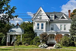 The John S. Silvers Mansion, built in 1886
 -
 The Cranbury Inn


Cranberry Mills
[edit]The nomination form describes how "Cranbury is the best preserved 19th century village in Middlesex County" and states that "While there are many small mill towns in New Jersey, few are in such an undisturbed environment as that of Cranbury."[27][119] The John S. Silvers Mansion, built 1886, features Queen Anne style architecture.[119] The Elizabeth M. Wagner History Center of the Cranbury Historical and Preservation Society is located in a former gristmiller's house and has a display on Cranberry Mills.[120] Cranberry Mills is an exemplary historic showcase of Cranbury's importance as a bustling mill town during the 18th/19th centuries. It was located along Cranbury Brook, a tributary of the Millstone River (which in turn is a major tributary of the Raritan River).
-
 Elizabeth M. Wagner History Center
 -
 Information on Cranberry Mills


Places of worship
[edit]The First Presbyterian Church was founded c. 1740 and the current church was built in 1839. The United Methodist Church was built in 1848. Both are contributing properties of the historic district.[119]
-
 First Presbyterian Church
 -
 United Methodist Church


Infrastructure
[edit]Transportation
[edit]Roads and highways
[edit]_from_the_overpass_for_Middlesex_County_Route_615_(Cranbury_Station_Road)_in_Cranbury_Township,_Middlesex_County,_New_Jersey.jpg)
As of May 2010[update], the township had a total of 51.25 miles (82.48 km) of roadways, of which 31.08 miles (50.02 km) were maintained by the municipality, 12.85 miles (20.68 km) by Middlesex County and 3.16 miles (5.09 km) by the New Jersey Department of Transportation and 4.16 miles (6.69 km) by the New Jersey Turnpike Authority.[121]
Several major roads and highways pass through the township[122] Cranbury hosts a 4-mile (6.4 km) section of Interstate 95 (the New Jersey Turnpike).[123] While there are no exits in Cranbury, the township is accessible by the Turnpike in neighboring East Windsor Township (Exit 8) and Monroe Township (Exit 8A). The Molly Pitcher Service Area is located at mile marker 71.7 on the southbound side.[124]
Other significant roads passing through Cranbury include U.S. Route 130,[125] County Route 535,[126] County Route 539,[127] County Route 615[128] and County Route 614.[129]
Public transportation
[edit]Middlesex County offers the M6 MCAT shuttle route providing service to Jamesburg and Plainsboro Township.[130]
Healthcare
[edit]
Penn Medicine Princeton Medical Center is a 355-bed regional non-profit, tertiary and academic medical center located in neighboring Plainsboro Township. The hospital services the greater Princeton region in central New Jersey. It is owned by the Penn Medicine Health System and is the only such hospital in the state of New Jersey.[131]
Other nearby regional hospitals and healthcare networks that are accessible to the township include CentraState Medical Center in Freehold Township, the Old Bridge Township division of Raritan Bay Medical Center, and Saint Peter's University Hospital and Robert Wood Johnson University Hospital in nearby New Brunswick.
Notable people
[edit]People who were born in, residents of, or otherwise closely associated with Cranbury include:
- Jessica Lee Ware (born 1977), Canadian-American evolutionary biologist and entomologist[132]
- Todd Beamer (1968–2001), passenger aboard United Airlines Flight 93, who said "Let's roll" to fellow passengers with whom he was planning an attack on terrorists who had taken over the cockpit[133]* Melanie Balcomb (born 1962), head coach of the Vanderbilt Commodores women's basketball team[134]
- Scott Brunner (born 1957), quarterback who played in the NFL from 1981 to 1986, most notably for the New York Giants[135]
- Ronald C. Davidson (1941–2016), physicist, professor and scientific administrator who served as the first director of the MIT Plasma Science and Fusion Center and as director of the Princeton Plasma Physics Laboratory[136]
- Wendy Gooditis (born Gwendolyn Wallace in 1960), politician who represents Virginia's 10th House of Delegates district in the Virginia House of Delegates[137]
- Noah Harlan, independent filmmaker[138]
- Hughie Lee-Smith (1915–1999), artist[139]
- Cicero Hunt Lewis (1826–1897), merchant[140]
- Robert Lougy, judge on the New Jersey Superior Court who served as acting New Jersey Attorney General in 1996[141]
- Charles McKnight (1750–1791), physician during and after the American Revolutionary War[142]
- Jan Morris (1926–2020), Welsh travel writer and historian, lived in Cranbury for several months in the 1950s whose impressions of the town are recorded in the book Coast to Coast: A Journey Across 1950s America[143]
- Henry Perrine (1797–1840), physician, horticulturist and enthusiast for introducing tropical plants into cultivation in the US[144]
In popular culture
[edit]Cranbury is referenced in the 2014 movie Edge of Tomorrow, as the hometown of Major William Cage (played by Tom Cruise). When asked if people of Cranbury plant cranberries, Cage answered: "Tomatoes, best I've ever had."[145]
See also
[edit]References
[edit]- ^ a b c d e f 2019 Census Gazetteer Files: New Jersey Places, United States Census Bureau. Accessed July 1, 2020.
- ^ a b US Gazetteer files: 2010, 2000, and 1990, United States Census Bureau. Accessed September 4, 2014.
- ^ a b c Township Committee, Cranbury Township. Accessed January 5, 2025. "The Township Committee is the governing body established by State law for the Township form of government. The membership of the Cranbury Township Committee was expanded from three to five in January 1990. The terms of the members are for three years, staggered, so that at least one member is up for election every year. The membership annually chooses one of the members as Mayor."
- ^ Administration, Cranbury Township. Accessed January 5, 2025.
- ^ Clerk / Registrar, Cranbury Township. Accessed January 5, 2025.
- ^ a b 2012 New Jersey Legislative District Data Book, Rutgers University Edward J. Bloustein School of Planning and Public Policy, March 2013, p. 70.
- ^ U.S. Geological Survey Geographic Names Information System: Township of Cranbury, Geographic Names Information System. Accessed March 5, 2013.
- ^ a b c Total Population: Census 2010 - Census 2020 New Jersey Municipalities, New Jersey Department of Labor and Workforce Development. Accessed December 1, 2022.
- ^ a b Annual Estimates of the Resident Population for Minor Civil Divisions in New Jersey: April 1, 2020 to July 1, 2023, United States Census Bureau, released May 2024. Accessed May 16, 2024.
- ^ a b Population Density by County and Municipality: New Jersey, 2020 and 2021, New Jersey Department of Labor and Workforce Development. Accessed March 1, 2023.
- ^ Look Up a ZIP Code for Cranbury, NJ, United States Postal Service. Accessed July 5, 2012.
- ^ Zip Codes, State of New Jersey. Accessed September 2, 2013.
- ^ Area Code Lookup - NPA NXX for Cranbury, NJ, Area-Codes.com. Accessed June 27, 2025.
- ^ a b U.S. Census website, United States Census Bureau. Accessed September 4, 2014.
- ^ Geographic Codes Lookup for New Jersey, Missouri Census Data Center. Accessed April 30, 2022.
- ^ US Board on Geographic Names, United States Geological Survey. Accessed September 4, 2014.
- ^ a b c d e DP-1 - Profile of General Population and Housing Characteristics: 2010 for Cranbury township, Middlesex County, New Jersey Archived February 12, 2020, at archive.today, United States Census Bureau. Accessed July 5, 2012.
- ^ a b Profile of General Demographic Characteristics: 2010 for Cranbury township Archived 2011-10-06 at the Wayback Machine, New Jersey Department of Labor and Workforce Development. Accessed July 5, 2012.
- ^ Table 7. Population for the Counties and Municipalities in New Jersey: 1990, 2000 and 2010, New Jersey Department of Labor and Workforce Development, February 2011. Accessed May 1, 2023.
- ^ Capuzzo, Jill P. "Living in Cranbury, N.J.; One Town, Many Personalities", The New York Times, February 25, 2014. Accessed October 2, 2023.
- ^ New York-Newark, NY-NJ-CT-PA Combined Statistical Area, United States Census Bureau. Accessed October 2, 2023.
- ^ a b Rizzo, Olivia; and D'Elia, Gianluca. "These towns have some of the steadiest tax rates in the state. What’s their secret?", NJ Advance Media for NJ.com, March 9, 2019. Accessed June 27, 2025. "The average homeowner’s municipal tax payment in Cranbury Township is set to reach a historic low in 2019 with a reduction of about $650 on average, and the rate could stay flat for the next two years, according to Mayor Jay Taylor. The municipal tax rate already stayed flat in 2017 and 2018.... Cranbury’s low municipal tax rate is partially the result of the township establishing a robust warehouse district that, in the past decade, welcomed Wayfair, Amazon and Home Depot. Both Route 130 and the New Jersey Turnpike run through the small Middlesex County township, making it an ideal location."
- ^ From George Washington to Major General Lafayette, 26 June 1778, Founders Online at National Archives and Records Administration. Accessed December 3, 2019.
- ^ a b c Cheslow, Jerry. "Historic, Sparsely Settled -- and Loving It", The New York Times, March 16, 1997. Accessed July 14, 2011. "The Middlesex County community is celebrating the 300th anniversary of the first documented European settlement in the area.... Cranbury pays tuition to send 106 high school students to nearby Princeton High School. According to Cranbury's Chief School Administrator, Robert J. Bartoletti, 87 percent of the town's youngsters go on to higher education.... As part of the addition, the 28,000-volume Cranbury Public Library, which shares space with the school library, is also being expanded to 6,000 square feet from 4,000 and the school's computers are to be enhanced through the networking of all of the classrooms into the library."
- ^ To George Washington from Major General Lafayette, 25 June 1778, Founders Online at National Archives and Records Administration. Accessed December 3, 2019.
- ^ Cheslow, Jerry. "If You're Thinking of Living in: Cranbury", The New York Times, December 29, 1991. Accessed February 20, 2024. "Aaron Burr, fleeing to Philadelphia after killing Alexander Hamilton in a duel in Weehawken in 1804, stopped at what is now the Cranbury Inn at the southern end of Main Street to eat and change horses."
- ^ a b History, Cranbury Township. Accessed December 3, 2019. "The marshy land near the mill site might have grown cranberries, hence the name. On 18th Century maps, the name appears as Cranberry and Cranberry Town. In 1857, Reverend Joseph G. Symmes felt the name was incorrectly spelled and suggested it be changed to Cranbury. In Old English 'bury' (connoting 'burgh') could be spelled bury, bery, or berry. In 1869, the town and the brook were renamed Cranbury."
- ^ Hutchinson, Viola L. The Origin of New Jersey Place Names, New Jersey Public Library Commission, May 1945. Accessed August 28, 2015.
- ^ John Quincy Adams diary 39, 1 December 1832 - 31 May 1835, page 179, Massachusetts Historical Society. Accessed September 2, 2013.
- ^ A history book on Cranbury says the accident happened 4 miles from Hightstown, putting the accident near today's retirement communities in Monroe Township. However, the book refers to John Quincy Adams' diary. See Chambers, John Whiteclay. Cranbury: A New Jersey Town from the Colonial Era to the Present, p. 50. Rutgers University Press, 2012. ISBN 9780813553580. Accessed November 10, 2015.
- ^ a b Snyder, John P. The Story of New Jersey's Civil Boundaries: 1606-1968, Bureau of Geology and Topography; Trenton, New Jersey; 1969. p. 169-170. Accessed July 5, 2012.
- ^ Barn Park, Cranbury Township. Accessed December 3, 2019. "The Parsonage barn originally belonged to the Parsonage Plantation, c. 1759, of the First Presbyterian Church of Cranbury. It was dismantled in 2004 and stored for five years. In 2010, a foundation was laid and the repaired timbers were re-erected with funding from the Cranbury Historical and Preservation Society, Cranbury Landmarks, Inc., and the Township of Cranbury."
- ^ Guion, Payton. "Marijuana legalization would force tough choice for N.J. towns", NJ Advance Media for NJ.com, November 15, 2017. Accessed November 15, 2017. "NJ Advance Media reached out to mayors in all five towns that have medical dispensaries: Bellmawr, Cranbury, Egg Harbor, Montclair and Woodbridge."
- ^ Duggan, Julia. "Cranbury joins long list of NJ towns to ban weed businesses", Courier News, July 15, 2021. Accessed November 17, 2022. "The Cranbury Township Council unanimously passed an ordinance Monday that bans all types of marijuana businesses from operating here."
- ^ "1713 East Jersey Cottage - A Rediscovered Connection to 18th Century Cranbury", Cranbury Historical and Preservation Society, August 31, 2022. Accessed May 10, 2023. "The Cranbury Museum is once again open, and features an exhibit telling the story of the 1713 East Jersey Cottage. Rediscovered and saved by the Cranbury Historical and Preservation Society, the 1700s House was relocated to Millstone Park in late 2019."
- ^ Marshall, Nyah (June 12, 2025). "'Once it's gone, it's gone forever.' Family and neighbors make last plea to save N.J. farm from seizure". NJ.com. Retrieved June 13, 2025.
- ^ Johnson, Anthony (May 28, 2025). "NJ family fights to keep farm from being seized by town for affordable housing". WABC-TV. Retrieved June 13, 2025.
- ^ "The Official Website of Governor Phil Murphy".
- ^ a b New Jersey: 2010 - Population and Housing Unit Counts - 2010 Census of Population and Housing (CPH-2-32), United States Census Bureau, August 2012. Accessed November 28, 2012.
- ^ GCT-PH1 - Population, Housing Units, Area, and Density: 2010 - County -- County Subdivision and Place from the 2010 Census Summary File 1 for Middlesex County, New Jersey Archived February 12, 2020, at archive.today, United States Census Bureau. Accessed November 28, 2012.
- ^ "Explore Census Data". data.census.gov. Retrieved July 6, 2025.
- ^ Locality Search, State of New Jersey. Accessed May 21, 2015.
- ^ Areas touching Cranbury Township, MapIt. Accessed July 13, 2016.
- ^ Municipalities Archived February 1, 2020, at the Wayback Machine, Middlesex County, New Jersey. Accessed December 1, 2019.
- ^ New Jersey Municipal Boundaries, New Jersey Department of Transportation. Accessed November 15, 2019.
- ^ Compendium of censuses 1726-1905: together with the tabulated returns of 1905, New Jersey Department of State, 1906. Accessed September 2, 2013.
- ^ Porter, Robert Percival. Preliminary Results as Contained in the Eleventh Census Bulletins: Volume III - 51 to 75, p. 98. United States Census Bureau, 1890. Accessed November 22, 2012.
- ^ Thirteenth Census of the United States, 1910: Population by Counties and Minor Civil Divisions, 1910, 1900, 1890, United States Census Bureau, p. 337. Accessed July 5, 2012.
- ^ Fifteenth Census of the United States : 1930 - Population Volume I, United States Census Bureau, p. 717. Accessed July 5, 2012.
- ^ Table 6: New Jersey Resident Population by Municipality: 1940 - 2000, Workforce New Jersey Public Information Network, August 2001. Accessed May 1, 2023.
- ^ a b c d e Census 2000 Profiles of Demographic / Social / Economic / Housing Characteristics for Pompton Lake borough, New Jersey Archived 2012-08-01 at the Wayback Machine, United States Census Bureau. Accessed July 5, 2012.
- ^ a b c d e DP-1: Profile of General Demographic Characteristics: 2000 - Census 2000 Summary File 1 (SF 1) 100-Percent Data for Cranbury township, Middlesex County, New Jersey Archived February 12, 2020, at archive.today, United States Census Bureau. Accessed November 22, 2012.
- ^ DP03: Selected Economic Characteristics from the 2006-2010 American Community Survey 5-Year Estimates for Cranbury township, Middlesex County, New Jersey Archived February 12, 2020, at archive.today, United States Census Bureau. Accessed July 5, 2012.
- ^ "Associated University Presses". Associated University Presses. Retrieved February 2, 2018.
- ^ Inventory of Municipal Forms of Government in New Jersey, Rutgers University Center for Government Studies, July 1, 2011. Accessed June 1, 2023.
- ^ "Forms of Municipal Government in New Jersey", p. 7. Rutgers University Center for Government Studies. Accessed June 1, 2023.
- ^ 2024 Municipal Data Sheet, Cranbury Township. Accessed April 21, 2024.
- ^ Tuesday, November 5 General Election Official Results, Middlesex County, New Jersey, updated November 27, 2024. Accessed January 1, 2025.
- ^ November 7, 2023 General Election Official Results, Middlesex County, New Jersey, December 7, 2023. Accessed January 1, 2024.
- ^ November 8, 2022 General Election Official Results, Middlesex County, New Jersey, updated November 22, 2022. Accessed January 1, 2023.
- ^ 2023 General Tax Rates, New Jersey Department of Treasury. Accessed January 5, 2025
- ^ Marcus, Samantha. "These are the towns with the highest property taxes in each of N.J.’s 21 counties", NJ Advance Media for NJ.com, April 22, 2019. Accessed November 5, 2019. "The average property tax bill in New Jersey was $8,767 last year. But there can be big swings from town to town and county to county.... The average property tax bill in Cranbury Township was $11,960 in 2018, the highest in Middlesex County."
- ^ Plan Components Report, New Jersey Redistricting Commission, December 23, 2011. Accessed February 1, 2020.
- ^ Municipalities Sorted by 2011-2020 Legislative District, New Jersey Department of State. Accessed February 1, 2020.
- ^ 2019 New Jersey Citizen's Guide to Government, New Jersey League of Women Voters. Accessed October 30, 2019.
- ^ Districts by Number for 2011-2020, New Jersey Legislature. Accessed January 6, 2013.
- ^ Directory of Representatives: New Jersey, United States House of Representatives. Accessed January 3, 2019.
- ^ Biography, Congresswoman Bonnie Watson Coleman. Accessed January 3, 2019. "Watson Coleman and her husband William reside in Ewing Township and are blessed to have three sons; William, Troy, and Jared and three grandchildren; William, Kamryn and Ashanee."
- ^ States in the Senate: New Jersey, United States Senate. Accessed January 23, 2025. "Cory A. Booker (D) Hometown: Newark; Andy Kim (D) Hometown: Moorestown"
- ^ Legislative Roster for District 14, New Jersey Legislature. Accessed January 18, 2024.
- ^ Board of County Commissioners, Middlesex County, New Jersey. Accessed May 1, 2022. "The residents of Middlesex County's 25 municipalities elect seven persons to serve as members of the Board of County Commissioners. The Commissioners are elected at large to staggered three-year terms in the November general election. In January of each year, the Board reorganizes, selecting one Commissioner to be County Commissioner Director and another to be County Commissioner Deputy Director."
- ^ Ronald G. Rios, Middlesex County, New Jersey. Accessed May 1, 2022.
- ^ Shanti Narra, Middlesex County, New Jersey. Accessed May 1, 2022.
- ^ Claribel A. Azcona-Barber, Middlesex County, New Jersey. Accessed May 1, 2022.
- ^ Charles Kenny, Middlesex County, New Jersey. Accessed May 1, 2022.
- ^ Leslie Koppel, Middlesex County, New Jersey. Accessed May 1, 2022.
- ^ Chanelle Scott McCullum, Middlesex County, New Jersey. Accessed May 1, 2022.
- ^ Charles E. Tomaro, Middlesex County, New Jersey. Accessed May 1, 2022.
- ^ 2022 County Data Sheet, Middlesex County, New Jersey. Accessed May 1, 2022.
- ^ Nancy J. Pinkin, Middlesex County, New Jersey. Accessed May 1, 2022.
- ^ Clerks, Constitutional Officers Association of New Jersey. Accessed June 19, 2022.
- ^ Mildred S. Scott, Middlesex County, New Jersey. Accessed May 1, 2022.
- ^ Sheriffs, Constitutional Officers Association of New Jersey. Accessed June 19, 2022.
- ^ Claribel Cortes, Middlesex County, New Jersey. Accessed May 1, 2022.
- ^ Constitutional Officers, Middlesex County, New Jersey. Accessed May 1, 2022.
- ^ Surrogates, Constitutional Officers Association of New Jersey. Accessed June 19, 2022.
- ^ Voter Registration Summary - Middlesex, New Jersey Department of State Division of Elections, March 23, 2011. Accessed November 22, 2012.
- ^ "NJ DOS - Division of Elections - Election Results Archive". nj.gov. Retrieved January 16, 2025.
- ^ "Nov 7, 2000 General Election". Middlesex County NJ. Retrieved November 9, 2025.
- ^ "Presidential General Election Results - November 6, 2012 - Middlesex County" (PDF). New Jersey Department of Elections. March 15, 2013. Retrieved December 24, 2014.
- ^ "Number of Registered Voters and Ballots Cast - November 6, 2012 - General Election Results - Middlesex County" (PDF). New Jersey Department of Elections. March 15, 2013. Retrieved December 24, 2014.
- ^ 2008 Presidential General Election Results: Middlesex County, New Jersey Department of State Division of Elections, December 23, 2008. Accessed November 22, 2012.
- ^ 2004 Presidential Election: Middlesex County, New Jersey Department of State Division of Elections, December 13, 2004. Accessed November 22, 2012.
- ^ "NJ DOS - Division of Elections - Election Results Archive". nj.gov. Retrieved January 16, 2025.
- ^ "Governor - Middlesex County" (PDF). New Jersey Department of Elections. January 29, 2014. Archived from the original (PDF) on September 10, 2015. Retrieved December 24, 2014.
- ^ "Number of Registered Voters and Ballots Cast - November 5, 2013 - General Election Results - Middlesex County" (PDF). New Jersey Department of Elections. January 29, 2014. Retrieved December 24, 2014.
- ^ 2009 Governor: Middlesex County Archived 2012-10-17 at the Wayback Machine, New Jersey Department of State Division of Elections, December 31, 2009. Accessed November 22, 2012.
- ^ "NJ DOS - Division of Elections - Election Results Archive". nj.gov. Retrieved January 16, 2025.
- ^ "NJ DOS - Division of Elections - Election Results Archive". nj.gov. Retrieved January 16, 2025.
- ^ Cranbury Township Board of Education District Policy 0110 - Identification, Cranbury School District. Accessed September 23, 2024. "Purpose: The Board of Education exists for the purpose of providing a thorough and efficient system of free public education in grades K through 8 in the Cranbury School District. Composition: The Cranbury School District is comprised of all the area within the municipal boundaries of Cranbury Township."
- ^ School Performance Reports for the Cranbury Township School District, New Jersey Department of Education. Accessed April 3, 2024.
- ^ New Jersey School Directory for the Cranbury School District, New Jersey Department of Education. Accessed February 1, 2024.
- ^ District information for Cranbury Township School District, National Center for Education Statistics. Accessed February 1, 2024.
- ^ National Blue Ribbon Schools Program: Schools Recognized 1982 Through 2019 (PDF), United States Department of Education. Accessed September 1, 2024.
- ^ 2009 Blue Ribbon Schools: All Public and Private Schools, United States Department of Education, p. 13. Accessed July 15, 2011.
- ^ 2016 National Blue Ribbon Schools All Public and Non-Public, National Blue Ribbon Schools Program. Accessed November 13, 2016.
- ^ Princeton Public Schools 2015 Report Card Narrative, New Jersey Department of Education. Accessed June 1, 2016. "As we strive to serve the more than 3500 students from the Princeton and Cranbury communities, we do so knowing that our work with them in the classroom, on the athletic field, and on the stage matters deeply to each one and to the larger society into which they will graduate."
- ^ Capuzzo, Jill P. "Cranbury, N.J.: One Town, Many Personalities", The New York Times, February 25, 2014. Accessed November 2, 2014. "About 545 students in prekindergarten through Grade 8 attend Cranbury School, which has twice been recognized as a National Blue Ribbon School of Excellence. For grades 9 to 12, they move on to Princeton High School, where there are 1,445 students."
- ^ Staff. "Cranbury trims 23 jobs in wake of aid reduction", The Times, March 25, 2010. Accessed November 2, 2014. "Cranbury public schools serve about 600 students in pre-kindergarten through eighth grade. The district's high school students attend Princeton High School."
- ^ Board of Education Members Archived 2014-11-03 at the Wayback Machine, Princeton Public Schools. Accessed November 2, 2014.
- ^ School data for Princeton High School, National Center for Education Statistics. Accessed February 1, 2024.
- ^ Kilby, David. "Cranbury: HHS alumni recalls how school used to be", CentralJersey.com, June 24, 2011. Accessed October 3, 2017. "Cranbury stopped sending its students to HHS in 1965, then it began sending its students to Hightstown-East Windsor High School. Cranbury students soon would go to Lawrence High School, then to Princeton High School, which is where they go today."
- ^ Heyboer, Kelly. "How to get your kid a seat in one of N.J.'s hardest-to-get-into high schools", NJ Advance Media for NJ.com, February 23, 2019. Accessed February 8, 2025. "Middlesex County has two stand-alone career academies for high-achieving students: the Academy for Science, Math and Engineering Technology, located on the campus of Middlesex County College in Edison, and the Academy for Allied Health and Biomedical Sciences in Woodbridge. How to apply: Students must attend a mandatory information session and submit an application by November of their 8th grade year."
- ^ About Our Schools, Middlesex County Magnet Schools. Accessed February 8, 2025. "These high schools are free public schools that offer hands-on, integrated learning opportunities for students in grades 9-12 interested in all types of careers as well as higher education. Any student who resides anywhere in Middlesex County's 25 municipalities student may apply to the school district. If accepted, the home school district will permit the student to attend and will organize daily transportation at no cost to the student's family."
- ^ "New Jersey Library Construction Bond Act". New Jersey State Library. Retrieved May 9, 2023.
- ^ Home page, Cranbury Public Library. Accessed June 30, 2021.
- ^ "National Register Information System – (#80002502)". National Register of Historic Places. National Park Service. November 2, 2013.
- ^ "New Jersey and National Registers of Historic Places - Middlesex County" (PDF). New Jersey Department of Environmental Protection - Historic Preservation Office. September 28, 2021. p. 1.
- ^ a b c d Karschner, Terry; Walsh, Ruth (January 1979). "National Register of Historic Places Inventory/Nomination: Cranbury Historic District". National Park Service. With accompanying 77 photos
- ^ "Elizabeth M. Wagner History Center". Cranbury Historical and Preservation Society.
- ^ Middlesex County Mileage by Municipality and Jurisdiction, New Jersey Department of Transportation, May 2010. Accessed July 18, 2014.
- ^ Middlesex County Road Map, New Jersey Department of Transportation. Accessed December 1, 2019.
- ^ Interstate 95 Straight Line Diagram, New Jersey Department of Transportation, updated August 2014. Accessed December 3, 2019.
- ^ Travel Resources: Interchanges, Service Areas & Commuter Lots, New Jersey Turnpike. Accessed July 14, 2011.
- ^ U.S. Route 130 Straight Line Diagram, New Jersey Department of Transportation, updated March 2018. Accessed December 3, 2019.
- ^ County Route 535 Straight Line Diagram, New Jersey Department of Transportation, updated October 2012. Accessed December 3, 2019.
- ^ County Route 539 Straight Line Diagram, New Jersey Department of Transportation, updated October 2012. Accessed December 3, 2019.
- ^ Middlesex County Route 615 Straight Line Diagram, New Jersey Department of Transportation, updated May 2011. Accessed December 3, 2019.
- ^ Middlesex County Route 615 Straight Line Diagram, New Jersey Department of Transportation, updated May 2011. Accessed December 3, 2019.
- ^ Mass Transit, Keep Middlesex Moving. Accessed October 2, 2014.
- ^ [1], Penn Medicine: Princeton Medical Center, Our locations. Accessed July 4, 2023.
- ^ "Jessica L. Ware | Entomological Society of America". www.entsoc.org. Retrieved May 9, 2023.
- ^ 13-minute call bonds her forever with hero, Pittsburgh Post-Gazette, September 22, 2001. "Beamer, 32, of Cranbury, N.J., was the only passenger who dialed zero for the Airfone operator."
- ^ Konick, Emery Jr. "Women's sports at center court", Home News Tribune, August 17, 2004. Accessed July 14, 2011. "Melanie Balcomb of Cranbury is the head women's basketball coach at Vanderbilt and one of the most successful young women's coaches in the nation."
- ^ "UD Hall of Fame names nine new members", University of Delaware, October 5, 2004. Accessed February 19, 2020. "Scott Brunner... He currently resides in Cranbury, N.J., and has three children, daughters Ashley (20) and Whitney (16) and son Adam (16)."
- ^ Chang, Kenneth. "Ronald C. Davidson, Pioneer of Fusion Power, Dies at 74", The New York Times, May 29, 2016. Accessed May 30, 2016. "Ronald C. Davidson, who oversaw one of the biggest advances in fusion energy research, attempting to replicate the power of the sun, died on May 19 at his home in Cranbury, N.J. He was 74."
- ^ About, Wendy Gooditis. Accessed February 19, 2020. "Wendy was raised to work hard and serve others. She grew up in Cranbury, New Jersey with two older brothers."
- ^ Rubin, Debra. "Day school and punk rock collide in teen novel", New Jersey Jewish News, December 6, 2010. Accessed February 19, 2020. "The South Orange native author spoke to NJJN by phone from her Manhattan home, where she lives with her Emmy Award-winning filmmaker husband Noah Harlan, a Cranbury native who grew up attending Congregation Beth Chaim in Princeton Junction."
- ^ Raynor, Vivien. "Art Review; A Painter's Evolution, Visual and Political", The New York Times, November 12, 1995. Accessed July 5, 2012. "Hughie Lee-Smith was born in Florida and schooled in Ohio and Michigan, notably at the Cleveland Institute of Art and Wayne State University in Detroit. He is nonetheless a New Jersey artist, and not just because of the many years he has lived in Cranbury."
- ^ Gaston, Joseph. Portland, Oregon, its history and builders:in connection with the antecedent explorations, discoveries, and movements of the pioneers that selected the site for the great city of the Pacific, Volume 2, S. J. Clarke Publishing Company, 1911. Accessed July 5, 2012. "The width of the continent separated Mr. Lewis from his birthplace after he came to the northwest for he was a native of Cranbury, Middlesex county, New Jersey, his birth having there occurred on the 22d of November, 1826."
- ^ "Governor Christie Names Robert Lougy as Acting State Attorney General", Attorney General of New Jersey, press release dated February 29, 2016. Accessed February 19, 2020. "A resident of Cranbury, Lougy graduated from Pennsylvania State University in 1994 and received his law degree from Columbia Law School in 2002."
- ^ Charles McKnight's Surgical Kit, Smithsonian Institution. Accessed May 30, 2016. "Charles McKnight was born in Cranbury, New Jersey, 10 October 1750."
- ^ Morris, Jan. "Once upon a time in America"[permanent dead link], Financial Times, May 9, 2008. Accessed August 27, 2008. "When I was resident in Cranbury more than half a century ago, it was a rustic haven in flat farmland country, with the remains of slave shacks, an 18th century inn, proud memories of the revolutionary war and a firehouse where firemen chewed the cud on kitchen chairs on the sidewalk outside, exchanging bucolic prejudices."
- ^ Wilkinson, Jerry. "Dr. Henry Perrine of Indian Key", Florida Keys History Museum. Accessed November 13, 2016. "Henry Edward Perrine was a descendant of a French Huguenot family who settled in New Jersey around 1665. He was born April 5, 1797 at Cranbury, New Jersey and taught school in Rockyhill, N.J. as a youth."
- ^ Whitty, Stephen. "Edge of Tomorrow review: Tom Cruise saves the world, maybe", Inside Jersey, May 28, 2014. Accessed August 25, 2022. "Tom Cruise is the hero (from Cranbury, N.J. no less) and he does the usual heroic Tom Cruise things — running hard, riding a motorcycle and acting cocky."
Further reading
[edit]- Chambers, John Whiteclay. Cranbury: A New Jersey Town From the Colonial Era to the Present. (Rivergate Books / Rutgers University Press; 2012)
External links
[edit]- Cranbury Township official website
- Cranbury Public Library website
- Cranbury Township School District
- School Performance Reports for the Cranbury School, New Jersey Department of Education
- Data for Cranbury Township School, National Center for Education Statistics
- Princeton High School
- Cranbury Historical and Preservation Society
- "Cranberry Mills". The Historical Marker Database.
Places adjacent to Cranbury, New Jersey | ||||||||||||||||
|---|---|---|---|---|---|---|---|---|---|---|---|---|---|---|---|---|
| ||||||||||||||||

| International | |
|---|---|
| Geographic | |
Cranbury, New Jersey
View on GrokipediaHistory
Colonial Origins and Early Settlement
Prior to European colonization, the region encompassing present-day Cranbury was inhabited by the Lenape, a subtribe of the Delaware Indians, who utilized trails that later formed the basis of early European roads.[6][2] The area fell within the proprietary colony of East New Jersey, granted by King Charles II to Sir George Carteret and others in 1664 following the English conquest of Dutch New Netherland.[6] Land was subdivided and sold by proprietors to encourage settlement on the fertile inner coastal plain suitable for agriculture.[6] European settlement likely began as early as 1680, with immigrants from England, Scotland, Holland, Germany, France, and Norway drawn to the area's rich soil and proximity to trade routes.[6] The earliest documented European structure was a tavern established by George Rescarrick in 1686 along the Great Post Road, accompanied by a 300-acre survey, positioning the site as an early waypoint between New York and Philadelphia.[2] The first recorded evidence of buildings in Cranbury dates to March 1, 1698, via a deed transferring property from Josiah Prickett, a butcher from Burlington, to John Harrison, explicitly including "all buildings" on the land, which Harrison had acquired from the Lenape around that time.[6][2] This transaction indicates pre-existing improvements, suggesting settlement predated the record slightly.[7] Initially known as Cranberry or Cranberry Town due to abundant local cranberry bogs, the community developed as a sparse agricultural outpost centered on farming and milling, with roads tracing Lenape paths to facilitate overland travel.[2] By the early 18th century, additional land purchases, such as Philip French's acquisition north of Cranbury Brook in 1703, supported gradual expansion.[6] The site's strategic location evolved it into a stagecoach stop by the mid-1700s, fostering inns and services amid primarily Quaker and Presbyterian settlers enduring harsh conditions to cultivate grains and livestock.[2] Religious institutions emerged, including the First Presbyterian Church in 1740 and a Baptist church in 1745, reflecting community consolidation before the American Revolution.[6]19th-Century Incorporation and Industrial Growth
Cranbury's economy in the early 19th century remained centered on agriculture, with gristmills processing grain from surrounding farms. The Cranberry Mills, originally established as a gristmill by Thomas Grubbs in 1737 on the south side of Cranbury Brook, continued operations into the 19th century, exemplifying the township's role as a milling hub supporting local farmers. By the mid-1800s, additional milling and small-scale manufacturing emerged, including a second mill constructed around 1840.[8] Improved transportation infrastructure drove economic expansion during the second and third quarters of the century. As a midway stop on stagecoach routes between New York City and Philadelphia, Cranbury benefited from increased commerce, with roadways, turnpikes, and emerging railroads facilitating the transport of agricultural goods and fostering trade.[6] This connectivity spurred population and business growth around the village core, transitioning from purely agrarian activities to include light industries such as furniture manufacturing and processing.[9] Notable establishments included A.S. Cole Son & Co., founded in 1858 for furniture and undertaking services, and the American Steam Coffee and Spice Mills, established in 1865 by John S. Davison, which processed goods for wider markets.[6] Agricultural support businesses, like Chamberlin & Barclay, Inc. and Simmons & Mount, Inc., dealt in fertilizers, seed potatoes, and farm machinery, reinforcing the linkage between farming and local industry. The First National Bank, organized in 1884, further indicated maturing commercial activity.[6] This period of steady growth culminated in formal political independence. On March 7, 1872, Cranbury Township was incorporated by an act of the New Jersey Legislature, carved from portions of South Brunswick and Monroe Townships in Middlesex County, reflecting the village's expanded influence and the need for self-governance amid rising economic vitality.[2] Unlike larger industrial centers in New Jersey, Cranbury's development emphasized preservation of its village character, avoiding transformative heavy manufacturing while leveraging mills and trade for prosperity.[10]20th-Century Suburbanization and Preservation Efforts
Cranbury's 20th-century development contrasted with the rapid suburban expansion seen in much of Middlesex County, where proximity to New York City and Philadelphia fueled population booms post-World War II. The township's population increased modestly from 1,342 in 1940 to 1,797 in 1950, 2,001 in 1960, 2,253 in 1970, 2,500 in 1990, and 3,227 in 2000, reflecting deliberate constraints on growth to preserve its rural-agricultural base amid regional highway construction and industrial shifts.[11] Unlike neighboring towns transformed into bedroom communities, Cranbury retained its historic village core and farmland through zoning ordinances that limited high-density housing and commercial sprawl.[9] Preservation efforts intensified in the late 20th century to counter suburban pressures. The township participated in New Jersey's Farmland Preservation Program, permanently protecting over 2,000 acres of agricultural land by 2000 to sustain farming and prevent urban encroachment.[2] In 1988, the Historic Preservation Advisory Committee was established to safeguard architectural and cultural resources, implementing master plan elements via ordinances that guide property rehabilitation and review development applications for compatibility with historic districts.[12] [13] The Cranbury Historic District, encompassing the central village with structures dating to the Revolutionary era, achieved National Register of Historic Places designation, covering approximately 200 buildings and reinforcing zoning restrictions against incompatible alterations.[14] These measures, supported by local advocacy from groups like the Cranbury Historical and Preservation Society, prioritized causal retention of the town's pre-industrial layout over unchecked development, enabling sustained low-density land use into the century's end.[12]Post-2000 Developments and Challenges
The township's population grew modestly in the early 2000s, increasing from 3,100 residents in the 2000 census to 3,857 by 2010, before stabilizing at 3,842 in the 2020 census, reflecting controlled suburban expansion amid preservation priorities.[15] Economic developments included the influx of logistics and warehousing facilities leveraging Cranbury's proximity to the New Jersey Turnpike and major highways; notably, Amazon announced a fulfillment center in 2017 as part of a statewide expansion, creating hundreds of full-time jobs and bolstering the local tax base.[16] Senior-oriented housing projects, such as the Four Seasons at Historic Cranbury active adult community, emerged to address demographic shifts toward an aging population, with the over-55 cohort expanding by nearly 40% since the early 2010s.[17][18] A core challenge has been reconciling state-mandated affordable housing obligations—stemming from New Jersey's Mount Laurel doctrine—with commitments to farmland preservation. Cranbury has preserved over 2,000 acres of farmland through the New Jersey Farmland Preservation Program since joining in the late 20th century, with significant post-2000 acquisitions emphasizing agricultural continuity in a region under development pressure.[2] This tension peaked in 2025 when the township, required to deliver 265 affordable units over the ensuing decade, pursued eminent domain against a 175-year-old Henry family farm on nearly 12 acres to site about half the units, prompting lawsuits, opposition from the property owners, the Sierra Club, and U.S. Department of Agriculture involvement under the Trump administration.[19][20] The plan drew criticism for prioritizing court-driven housing quotas over voluntary preservation incentives, despite the township's prior farmland successes.[21] Resolution came in October 2025 via a settlement agreement, exempting the farm from seizure and allowing it to remain in family hands, though the township must still meet its obligations through alternative sites.[22] Warehouse proliferation has introduced additional strains, including traffic congestion along routes like County Road 535 and potential environmental impacts from industrial expansion, as noted in regional reports on New Jersey's "warehouse sprawl" affecting rural-suburban fringes.[23] Ongoing infrastructure projects, such as the Southern Middlesex County North-South Truck Corridor, aim to mitigate these by improving freight movement, but residents have voiced concerns over quality-of-life erosion from unchecked logistics growth.[24]Geography
Location and Physical Features
Cranbury Township is situated in southern Middlesex County, central New Jersey, encompassing a total area of 13.43 square miles (34.79 km²), of which land comprises the majority with minimal water coverage.[1] [25] The township lies at geographic coordinates approximately 40°18′31″N 74°30′54″W, positioning it roughly 10 miles southeast of Trenton and 40 miles northeast of Philadelphia.[26] It borders South Brunswick Township to the north, Monroe Township to the east, Plainsboro Township to the northwest, and extends influences toward East Windsor Township in adjacent Mercer County to the west.[27] The physical terrain consists of level, low-relief landscapes typical of New Jersey's Inner Coastal Plain, with elevations averaging 92 to 105 feet (28 to 32 meters) above sea level and minimal variation across the area.[28] [29] Sandy, porous soils predominate, contributing to the region's agricultural suitability while influencing local hydrology through higher permeability.[30] Key hydrological features include Cranbury Brook, a stream that drains the township and feeds into the Millstone River watershed, along with Brainerd Lake, a central reservoir formed along the brook that supports recreational and ecological functions.[31] [32] Land use reflects this flat, arable physiography, with approximately 33% urban or developed areas, substantial agricultural fields, and preserved open spaces that maintain rural character amid suburban pressures.[25] Impervious surfaces cover about 13.8% of the land, exceeding thresholds that can impact stormwater runoff in this low-gradient setting.[25]Climate and Environmental Factors
Cranbury experiences a humid subtropical climate typical of central New Jersey, with hot, humid summers and cold winters moderated by proximity to the Atlantic Ocean and Delaware River watershed. Average annual precipitation totals approximately 48 inches, distributed relatively evenly throughout the year, while snowfall averages 23 inches annually. Summer highs often reach the mid-80s°F (29°C), with July averaging 86°F (30°C) daytime highs and nighttime lows around 68°F (20°C), accompanied by high humidity that can elevate heat index values. Winters feature average highs near 40°F (4°C) in January and lows dipping to 23°F (-5°C), with occasional nor'easters bringing heavy snow or rain.[33][34] The following table summarizes monthly climate averages derived from historical data for Cranbury:| Month | Average Low (°F) | Average High (°F) | Average Precipitation (in) |
|---|---|---|---|
| January | 23.4 | 40.2 | 3.52 |
| February | 24.9 | 42.8 | 2.64 |
| March | 31.8 | 50.5 | 4.34 |
| April | 41.7 | 62.1 | 3.98 |
| May | 51.8 | 71.6 | 3.94 |
| June | 61.7 | 80.1 | 4.02 |
| July | 66.9 | 84.6 | 4.72 |
| August | 65.5 | 82.6 | 4.25 |
| September | 58.6 | 76.1 | 3.70 |
| October | 47.5 | 64.9 | 3.86 |
| November | 37.6 | 53.8 | 3.54 |
| December | 28.4 | 43.5 | 3.78 |
Demographics
2020 Census Overview
As of the 2020 United States Census, the population of Cranbury Township, Middlesex County, New Jersey, was 3,844.[39][40] The township spans 13.28 square miles of land, yielding a population density of 289.4 people per square mile.[40] The census enumerated 1,388 housing units, with 1,323 occupied and 65 vacant, corresponding to an average household size of 2.88 persons.[41] Housing density stood at 104.5 units per square mile.[40] Racial and ethnic composition showed White residents comprising approximately 63.5% of the non-Hispanic population, Asian 23.1%, and Black or African American 7.2%, with Hispanic or Latino individuals of any race making up about 5.4%.[4][42] The median age was around 50.5 years, reflecting an older demographic profile.[3]Comparative Census Data (2010 and 2000)
The population of Cranbury Township increased from 3,227 in the 2000 United States Census to 3,857 in the 2010 United States Census, reflecting a growth of 630 residents or 19.5%.[43] The number of housing units rose from 1,121 in 2000 to 1,371 in 2010.[44][45] Racial and ethnic composition shifted modestly over the decade, with a decrease in the share of White residents and increases in Asian and Black shares.[44][45] The table below summarizes key categories:| Category | 2000 (n=3,227) | % | 2010 (n=3,857) | % |
|---|---|---|---|---|
| White alone | 2,865 | 88.8 | 3,106 | 80.5 |
| Black or African American alone | 73 | 2.3 | 133 | 3.4 |
| Asian alone | 239 | 7.4 | 530 | 13.7 |
| American Indian/Alaska Native alone | 0 | 0.0 | 4 | 0.1 |
| Native Hawaiian/Pacific Islander alone | 0 | 0.0 | 1 | 0.0 |
| Some other race alone | 7 | 0.2 | 14 | 0.4 |
| Two or more races | 43 | 1.3 | 69 | 1.8 |
| Hispanic or Latino (any race) | 55 | 1.7 | 99 | 2.6 |
Socioeconomic and Racial Composition
As of the 2020 United States Census, the racial composition of Cranbury Township reflected a majority White non-Hispanic population at 63.5%, followed by Asian non-Hispanic at 23.1% and Black or African American non-Hispanic at 7.16%, with remaining residents identifying as two or more races, other races, or Hispanic or Latino of any race in smaller proportions.[4] [42] This distribution indicates a relatively diverse community for a small suburban township, driven in part by proximity to professional employment centers like Princeton and proximity to major transportation routes attracting educated professionals.[15] Socioeconomically, Cranbury Township demonstrates affluence, with a median household income of $212,250 based on 2018-2022 American Community Survey estimates, more than double the statewide median of $101,050.[15] Per capita income reached $95,629, and the poverty rate was 4%, less than half the Middlesex County rate of 8.5% and well below the national average.[15] [4] These figures align with the township's profile as a high-income residential area, where homeownership rates exceed 90% and housing values support upper-middle-class stability.[15] Educational attainment further underscores socioeconomic strength, with approximately 78% of adults aged 25 and older holding a bachelor's degree or higher, surpassing both county and state averages of 45.1% and 42.9%, respectively.[15] This high level of postsecondary education correlates with professional occupations in sectors like pharmaceuticals, finance, and technology, common among commuters to nearby urban hubs.[4]| Demographic Indicator | Value | Comparison |
|---|---|---|
| Median Household Income | $212,250 | >2x NJ median ($101,050)[15] |
| Poverty Rate | 4% | <0.5x county rate (8.5%)[15] |
| Bachelor's Degree or Higher (25+) | ~78% | >1.7x state average (42.9%)[15] |