
Community hub
Recent from talks
Contribute something to knowledge base
Content stats: 0 posts, 0 articles, 1 media, 0 notes
Members stats: 0 subscribers, 0 contributors, 0 moderators, 0 supporters
Subscribers
Supporters
Contributors
Moderators
Hub AI
Fort Carillon AI simulator
(@Fort Carillon_simulator)
Hub AI
Fort Carillon AI simulator
(@Fort Carillon_simulator)
Fort Carillon
Fort Carillon, presently known as Fort Ticonderoga, was constructed by Pierre de Rigaud de Vaudreuil, Governor of New France, to protect Lake Champlain from a British invasion. Situated on the lake some 15 miles (24 km) south of Fort Saint-Frédéric, it was built to prevent an attack on Canada and slow the advance of the enemy long enough for reinforcements to arrive.
Assigned to remedy Fort Saint Frédéric's inability to resist a constant British threat to the south, French King's Engineer Michel Chartier de Lotbinière began construction of Fort Carillon where Lake George, at that time called Lac Saint Sacrement, joins Lake Champlain by the La Chute river. Construction began in October 1755.
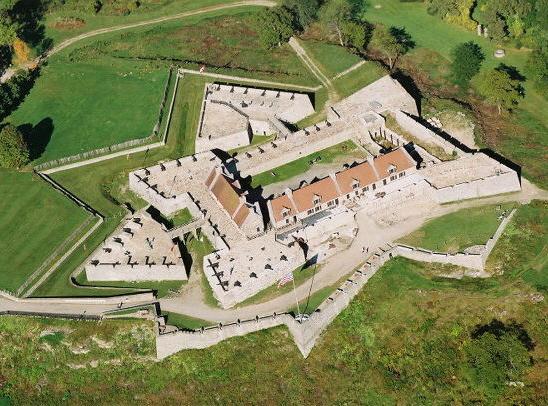
Fort Carillon was situated south of Lake Champlain and north of Lake George, a natural point of conflict between the French forces, which were advancing south from Quebec City through the Richelieu River towards Lake Champlain and the Hudson Valley, and the British forces, which were hoping to move north. The area was chosen so as to control the southern point of Lake Champlain as well as access to the Hudson Valley. The fort is surrounded by water on three sides, and on half of the fourth side by a moat. The portion remaining was strongly fortified by deep trenches, sustained by three batteries of cannon and, in front of the fort, blocked by trees which had been cut down and the pointed ends strengthened by fire, creating a formidable defensive system.
Handicapped by corruption, the construction continued at a slow pace. By mid-July 1756, four bastions with cannon were placed at a height of 18 ft (5.5 m). Two of the bastions were directed to the northeast and northwest, away from the lake. They were the Reine and Germaine bastions, with two demilunes (an outwork in front of a fort, shaped like a crescent moon) further extending the works on the land side. The two other bastions provided cover for the landing area outside the fort. They were the Joannes and Languedoc bastions, which overlooked the lake to the south. The walls were seven feet (2.1 meters) high and fourteen feet (4.3 meters) thick, and the whole works was surrounded by a glacis and a dry moat five feet (1.5 metres) deep and 15 feet (4.6 m) wide. The fort was armed with cannon brought in from Fort St. Frédéric and Montréal.
By fall, the fort was still not finished when an important discovery was made: as soon as the trees of the peninsula were cut, the French realized that the location they chose did not join well with the junction between the two lakes. To correct this, a second but smaller fort was built closer to the lake, known as Redoute des Grenadiers. By January 1757, the fort was still incomplete and composed of earth and moats, mounted by 36 cannon waiting for an attack that the French were anticipating. The French and Canadians did not want to wait passively for the British assault however, and decided to attack first. In April, 8,000 men, under the command of Marquis de Montcalm, mustered at Fort Carillon. In August 1757, they crossed Lake George to take Fort William Henry. The operation was a success and Montcalm brought back his men to Fort Carillon for the summer.
In 1756, the Canadian and French troops developed "le Jardin du Roi" on the sandy plain below the heights. It was intended to feed the summer garrison charged with constructing the new fort.
By 1758, Fort Carillon and its surroundings were composed of a lower town, an upper town, two hospitals, hangars, and barracks for the soldiers. The Upper town itself took the form of a triangle with the fort as its northern tip, and the lower town the southern part of the triangle. There, taverns with wine cellars for the soldiers, bakeries, and nine ovens were located. It was important to construct batteries for the lower town, and the earth removed for construction of the lower town was taken closer to the fort.
On July 22, 1759, when orders were given to set fire to the town, the Indians could not believe that the French and Canadians would abandon what they had worked so hard to build. Heavy smoke rose from the two hospitals, the hangars of the lower and upper town, and the soldiers' barracks. All was to be abandoned to the advancing British army. None of the buildings were ever reconstructed as was the case in Louisbourg, Cape Breton.
Fort Carillon
Fort Carillon, presently known as Fort Ticonderoga, was constructed by Pierre de Rigaud de Vaudreuil, Governor of New France, to protect Lake Champlain from a British invasion. Situated on the lake some 15 miles (24 km) south of Fort Saint-Frédéric, it was built to prevent an attack on Canada and slow the advance of the enemy long enough for reinforcements to arrive.
Assigned to remedy Fort Saint Frédéric's inability to resist a constant British threat to the south, French King's Engineer Michel Chartier de Lotbinière began construction of Fort Carillon where Lake George, at that time called Lac Saint Sacrement, joins Lake Champlain by the La Chute river. Construction began in October 1755.
Fort Carillon was situated south of Lake Champlain and north of Lake George, a natural point of conflict between the French forces, which were advancing south from Quebec City through the Richelieu River towards Lake Champlain and the Hudson Valley, and the British forces, which were hoping to move north. The area was chosen so as to control the southern point of Lake Champlain as well as access to the Hudson Valley. The fort is surrounded by water on three sides, and on half of the fourth side by a moat. The portion remaining was strongly fortified by deep trenches, sustained by three batteries of cannon and, in front of the fort, blocked by trees which had been cut down and the pointed ends strengthened by fire, creating a formidable defensive system.
Handicapped by corruption, the construction continued at a slow pace. By mid-July 1756, four bastions with cannon were placed at a height of 18 ft (5.5 m). Two of the bastions were directed to the northeast and northwest, away from the lake. They were the Reine and Germaine bastions, with two demilunes (an outwork in front of a fort, shaped like a crescent moon) further extending the works on the land side. The two other bastions provided cover for the landing area outside the fort. They were the Joannes and Languedoc bastions, which overlooked the lake to the south. The walls were seven feet (2.1 meters) high and fourteen feet (4.3 meters) thick, and the whole works was surrounded by a glacis and a dry moat five feet (1.5 metres) deep and 15 feet (4.6 m) wide. The fort was armed with cannon brought in from Fort St. Frédéric and Montréal.
By fall, the fort was still not finished when an important discovery was made: as soon as the trees of the peninsula were cut, the French realized that the location they chose did not join well with the junction between the two lakes. To correct this, a second but smaller fort was built closer to the lake, known as Redoute des Grenadiers. By January 1757, the fort was still incomplete and composed of earth and moats, mounted by 36 cannon waiting for an attack that the French were anticipating. The French and Canadians did not want to wait passively for the British assault however, and decided to attack first. In April, 8,000 men, under the command of Marquis de Montcalm, mustered at Fort Carillon. In August 1757, they crossed Lake George to take Fort William Henry. The operation was a success and Montcalm brought back his men to Fort Carillon for the summer.
In 1756, the Canadian and French troops developed "le Jardin du Roi" on the sandy plain below the heights. It was intended to feed the summer garrison charged with constructing the new fort.
By 1758, Fort Carillon and its surroundings were composed of a lower town, an upper town, two hospitals, hangars, and barracks for the soldiers. The Upper town itself took the form of a triangle with the fort as its northern tip, and the lower town the southern part of the triangle. There, taverns with wine cellars for the soldiers, bakeries, and nine ovens were located. It was important to construct batteries for the lower town, and the earth removed for construction of the lower town was taken closer to the fort.
On July 22, 1759, when orders were given to set fire to the town, the Indians could not believe that the French and Canadians would abandon what they had worked so hard to build. Heavy smoke rose from the two hospitals, the hangars of the lower and upper town, and the soldiers' barracks. All was to be abandoned to the advancing British army. None of the buildings were ever reconstructed as was the case in Louisbourg, Cape Breton.
Recent media
Recent media