
Community hub
Recent from talks
Contribute something
Nothing was collected or created yet.
Hamoaze
View on Wikipedia
| Hamoaze | |
|---|---|
 | |
 | |
| Physical characteristics | |
| Mouth | Plymouth Sound |
• coordinates | 50°23′44″N 4°12′28″W / 50.39556°N 4.20778°W |
| Basin features | |
| Tributaries | |
| • left |
|
| Inland ports | HMNB Devonport |
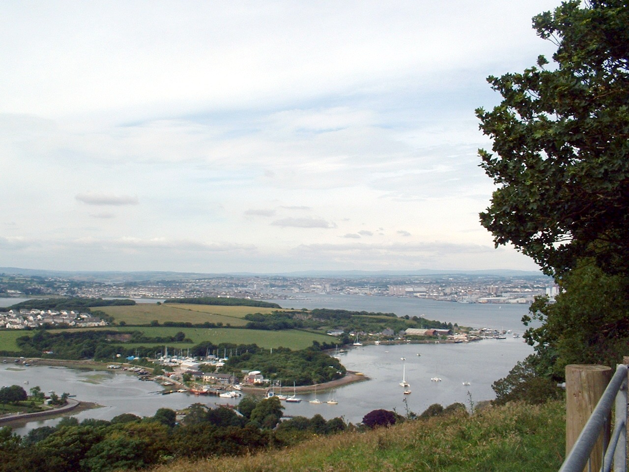
The Hamoaze (/hæmˈoʊz/; Cornish pronunciation: [ˈhɒmøz]) is an estuarine stretch of the English tidal River Tamar, between its confluence with the River Lynher and Plymouth Sound.
Etymology
[edit]The name first appears as ryver of Hamose in 1588. The first element is thought to refer to specifically to Ham in the parish of Weston Peverel, now a suburb of Plymouth (whose name in turn came from the Old English word hamm, meaning "water-meadow, land in the bend of a river"). The second element is thought to derive from Old English wāse meaning "mud" (as in "ooze"). Thus the name once meant "mud-banks at Ham". The name originally probably applied only to a creek running past Ham, which perhaps consisted of mud-banks at low tide, north of the present-day Devonport Dockyard. The name later came to be used for the main channel of the estuary into which the creek drained.[1]
Geography
[edit]The Hamoaze flows past Devonport Dockyard, which is one of three major bases of the Royal Navy today. The presence of large numbers of small watercraft is a challenge and hazard to the warships using the naval base and dockyard. Navigation on the waterway is controlled by the King's Harbour Master for Plymouth.[2][3]
Settlements on the banks of the Hamoaze are Saltash, Wilcove, Torpoint and Cremyll in Cornwall, as well as Devonport and Plymouth in Devon.
Two regular ferry services crossing the Hamoaze exist: the Torpoint Ferry (a chain ferry that takes vehicles) and the Cremyll Ferry (passengers and cyclists only).
A street in Torpoint bears the name Hamoaze Road, named after the stretch of river.
_laid_up_at_Plymouth,_13_January_1973.jpg)
See also
[edit]References
[edit]- ^ Gover, J. E. B.; Mawer, A.; Stenton, F. M. (1931–32). The Place-names of Devon. English Place-Name Society, 8-9. Vol. 1. Cambridge: Cambridge University Press. pp. 20, 246.
- ^ Queen's Harbour Master Plymouth
- ^ The Dockyard Port of Plymouth Order 1999
External links
[edit] Media related to Hamoaze at Wikimedia Commons
This Devon location article is a stub. You can help Wikipedia by expanding it. |
This Cornwall location article is a stub. You can help Wikipedia by expanding it. |
Hamoaze
View on GrokipediaEtymology
Origin of the Name
The name Hamoaze is derived from Old English elements, with "ham" referring to a water-meadow, enclosed land, or settlement, and "wāse" (also spelled wase) denoting mud or ooze, collectively translating to "the muddy place at Ham" or "mud-banks at the settlement." This etymology reflects the geographical features of the area, originally applying to a small, muddy creek rather than the broader estuary it now describes. The term "Ham" specifically alludes to the historic manor of Ham in the parish of Weston Peverel, Devon, near the site's location.[1] An alternative interpretation posits a Celtic origin, combining "ham" or "hem" (meaning settlement or border) with "oaze" or "uisg" (suggesting the end of a tidal river or water border), implying "the settlement at the river's tidal end." However, this view, proposed in 19th-century analyses, receives less scholarly support compared to the Old English derivation, as it lacks strong linguistic evidence from early records.[2] The earliest recorded usage of the name appears as "ryver of Hamose" in 1588 documents, indicating its application to a localized creek within the Tamar estuary at that time.[1]Historical References
The earliest documented references to the Hamoaze appear in late 16th-century maps and records near Plymouth, where the name is linked to the mudflats known as "Ham ooze" formed at the confluence of Ham Brook with the River Tamar estuary.[3] These nautical depictions highlight its role as a sheltered extension of the Tamar's lower reaches, providing anchorage amid the developing maritime activities around Plymouth.[3] In the 17th century, the name evolved in naval and legal records, often describing the Hamoaze as a strategic anchorage for vessels. For instance, a 1601 entry in Serjeant Hele’s Precedent Book records the ship Speedwell of Milbrooke "lying in the Ryver of Hamose" prior to a voyage to Ireland, using the spelling "Hamose."[4] Similarly, a 1637 Letters Patent concerning Cattewater harbor rights refers to it as "Hamoase," granting ballasting privileges to Saltash authorities within its bounds under the Duke of Cornwall's claim.[4] By the 18th century, naval logs routinely noted the Hamoaze for ship moorings and repairs; James Cook's 1756 log, for example, documents his return aboard HMS Eagle to Hamoaze on July 8 after travel from London.[5] Spelling variations such as "Hamose," "Hamoase," and the emerging "Hamoaze" persisted in British Admiralty and municipal documents through the 19th century, reflecting inconsistencies in official cartography and correspondence.[4] A 1804 letter from Lord Cochrane aboard HMS Pallas in the Hamoaze exemplifies the standardized form in naval contexts by this period.[4]Geography
Location and Boundaries
The Hamoaze is an estuarine stretch of the tidal River Tamar in southwest England, extending from the confluence with the River Lynher in the north to the entrance of Plymouth Sound in the south.[6] This reach forms part of the broader Tamar estuary, which serves as the historic county boundary between Devon to the east and Cornwall to the west.[7] The northern boundary is marked by the junction with the River Lynher near Saltash in Cornwall, while the southern limit aligns with the narrows leading into Plymouth Sound, near the historic site of the Plymouth Breakwater.[8] On the western (Cornish) side, the Hamoaze borders areas including Torpoint, and on the eastern (Devon) side, it adjoins Plymouth and Devonport.[7] The waterway is centered approximately at coordinates 50°23′44″N 4°12′28″W.[9] Adjacent to the Hamoaze are several creeks and lakes that function as tributaries, including Weston Mill Lake to the northeast and St John's Lake to the southwest, both draining into the main channel.[10] These features contribute to the estuarine complex without altering the primary north-south extent of the Hamoaze itself.[11]Physical Characteristics
The Hamoaze is a broad, deep estuarine stretch of the tidal River Tamar, formed at its confluence with the River Lynher, extending approximately 5.5 kilometers southward to Plymouth Sound. It averages about 1.2 kilometers in width along its navigable deep-water channel, providing sheltered access for maritime vessels. The estuary's seabed features central channels that reach depths of 15 to 20 meters, facilitating large-scale navigation while supporting adjacent shallower areas.[12][13] Characterized by extensive muddy banks and tidal flats, the Hamoaze's name derives from the Saxon "Ham-ooze," referring to the prominent mudflats that historically dominated the area due to sediment deposition. The sediment composition is predominantly silt and mud, with finer particles accumulating in subtidal and intertidal zones, influenced by inflows from the Tamar and Lynher rivers that transport suspended sediments into the lower estuary. These muddy substrates form the basis for intertidal mud communities, though some areas exhibit mixed muddy sands. Reclaimed land, such as the infilled Stonehouse Creek, has altered portions of these original tidal flats through historical development.[7][14] Key natural landmarks include Bull Point on the Devonport side, marking the transition where the Tamar widens into the Hamoaze and historically serving as a site for naval facilities. Nearby, Drake's Island lies at the entrance to Plymouth Sound, influencing the estuary's sheltered character. Artificial structures, such as the Plymouth Breakwater extending into the Sound, further define the outer boundaries and enhance protection for the Hamoaze's inner waters. These features collectively shape the estuary's terrain, balancing natural sedimentation with human modifications for navigational purposes.[15]Tidal and Hydrological Features
The Hamoaze experiences semi-diurnal tides, characterized by two high and two low waters each lunar day, typical of the region's coastal dynamics.[16] These tides have a typical range of 4 to 6 meters, varying between neap tides of approximately 3 meters and spring tides up to 6 meters, influenced by the Hamoaze's connection to Plymouth Sound and its exposure to the broader tidal regime of the English Channel.[16] Freshwater inflow into the Hamoaze primarily originates from the River Tamar, which drains a catchment area of approximately 917 square kilometers, delivering an average annual discharge that mixes with incoming seawater to form brackish conditions throughout much of the estuary.[17] This mixing creates a dynamic estuarine environment where freshwater dilutes the saline waters from Plymouth Sound, resulting in variable salinity profiles that shift with tidal cycles and seasonal river flow.[18] Tidal currents in the Hamoaze channels can reach speeds of 2 to 3 knots, particularly during spring ebb tides through narrower sections like the Narrows between Devil's Point and Wilderness Point, and are further modulated by prevailing winds and vessel movements such as ferry operations. These currents facilitate the transport of sediments and nutrients while contributing to the overall hydrological circulation.[7] A distinct salinity gradient exists along the Hamoaze, decreasing northward from 30-35 parts per thousand (ppt) at the mouth near Plymouth Sound to 20-25 ppt near the confluence with the River Lynher, reflecting the intensifying influence of freshwater inputs upstream.[18] This gradient influences local ecological patterns, such as the distribution of brackish flora on buoys.[19]History
Pre-Modern Period
The Hamoaze, as part of the Tamar estuary, shows evidence of early human activity dating back to the late Bronze Age and Iron Age, with settlements focused on resource extraction and trade. Archaeological excavations at Mount Batten, a promontory in Plymouth Sound adjacent to the estuary, reveal a fortified Iron Age hillfort and trading post established around 250 BCE, serving as a key hub for exporting tin from Cornish mines via maritime routes.[20] This site facilitated the long-distance tin trade that connected southwest Britain to Mediterranean Bronze Age civilizations, with isotopic analysis of artifacts confirming Cornish and Devonian tin sources were transported across Europe starting around 1300 BCE.[21] During the Roman period, the area retained its commercial importance, with Mount Batten functioning as a port for tin shipments.[20] In the medieval era, the Hamoaze supported local economies through fishing and small-scale trade, leveraging its sheltered inlet for coastal vessels. The Domesday Book of 1086 records nearby settlements such as Sudtone (modern Plymouth) and Tamertone (Tamerton), indicating Saxon-era hamlets or "hams" (homesteads) along the estuary used for agrarian and maritime pursuits, including fisheries for herring and pilchards. These communities engaged in regional trade, with quays like those at Cotehele facilitating the exchange of fish, wool, and minerals up the Tamar Valley. The estuary's role as a fishing ground is evidenced by medieval records of tidal weirs and nets in Plymouth Sound, sustaining populations in adjacent villages.[22] Navigation in the pre-modern Hamoaze was hindered by extensive mudflats and shifting sands, restricting access to shallow-draft boats and posing risks to larger vessels until later improvements. Early charts depict the area as "ham ooze," highlighting the muddy creeks that limited deep-water passage and required local knowledge for safe transit. These challenges confined maritime activity to inshore fishing and trade, with no significant dredging until the post-medieval period.Naval Expansion in the 16th-19th Centuries
The Hamoaze emerged as a vital naval anchorage in the 16th century, particularly during the Spanish Armada crisis of 1588, when it formed part of the secure sheltered waters of Plymouth Sound and the Tamar Estuary alongside the Cattewater. English naval forces under Sir Francis Drake and Lord Howard of Effingham utilized these waters to assemble and refit over 60 vessels in preparation for confronting the invading Spanish fleet, highlighting the area's strategic value as a safe harbor protected from westerly winds and enemy approach. Although formal dockyard plans were proposed during this era to bolster England's maritime defenses, they were not implemented until the following century due to fiscal constraints and shifting priorities.[23] The 17th and 18th centuries marked significant infrastructural growth, beginning with the establishment of Plymouth Dock (later renamed Devonport) on the eastern bank of the Hamoaze. In December 1690, the Admiralty awarded a contract to builder Robert Waters of Portsmouth to construct a stone wet dock and associated facilities at Point Frowd, with work commencing in 1691 and the initial dock operational by 1698; this development addressed the need for a western naval base to support operations against French threats during the Nine Years' War. By the mid-18th century, the yard had expanded with additional slips, storehouses, and barracks, employing hundreds in shipbuilding and maintenance. The Hamoaze also served as a primary location for laying up ships in ordinary after major conflicts, such as the War of the Austrian Succession (1748) and the Seven Years' War (1763), where decommissioned vessels were moored for preservation and crew dispersal, freeing resources for peacetime economies.[24][25] During the Napoleonic Wars (1793–1815), the Hamoaze functioned as a critical logistics hub, with its dockyard handling repairs, provisioning, and assembly for the Channel Fleet blockading French ports; ships frequently moored there for resupply, contributing to Britain's sustained naval superiority through efficient support of over 100 vessels at peak mobilization. The 19th century brought further expansions to adapt to industrial advancements, including the construction of the Keyham Steam Yard from the 1840s to service iron-hulled steam warships, featuring specialized basins and engineering workshops linked to the main dockyard via tunnel. Reclamation efforts transformed adjacent tidal areas, notably the development of the Royal William Victualling Yard on infilled land along Stonehouse Creek between 1826 and 1835, which included massive storehouses and bakeries to supply the fleet with bread, meat, and rum on an unprecedented scale. Notable events included the 1863 visit of HMS Warrior, the Royal Navy's pioneering ironclad launched in 1860, which moored in the Hamoaze for three months of modifications to enhance its armored hull and propulsion systems amid the shift to steam power.[26][27][28]20th and 21st Centuries
During the First World War, Devonport Dockyard on the Hamoaze played a crucial role in supporting the Royal Navy's convoy system by conducting repairs and refits on escort vessels and merchant ships, as well as launching new warships to counter German submarine threats in the Atlantic.[29] The dockyard's strategic location facilitated the assembly and departure of convoys from Plymouth Sound, which extended into the Hamoaze, ensuring vital supply lines remained operational amid the U-boat campaign that sank thousands of Allied vessels. In the Second World War, the Hamoaze continued as a vital hub for convoy operations, with merchant ships anchoring in adjacent Plymouth Sound to join escorted formations bound for distant theaters, while facing heightened U-boat dangers in the Battle of the Atlantic.[30] Devonport's facilities were heavily utilized for emergency repairs on damaged escorts and submarines, contributing to the Allied effort that ultimately neutralized the submarine menace through technological advances like improved radar and convoy tactics.[29] The 1973 laying up of the decommissioned aircraft carrier HMS Eagle in the Hamoaze marked a poignant milestone in the Royal Navy's post-war contraction, reflecting the end of large-scale carrier operations amid economic pressures and the shift away from imperial-era naval dominance.[31] Following the war, the training establishment HMS Impregnable at Devonport, which had prepared thousands of recruits on the Hamoaze since the 19th century, was progressively decommissioned through the 1940s and 1950s as the Royal Navy modernized its personnel programs. By the late 20th century, the Hamoaze's significance evolved with the basing and refit of Trident nuclear-armed submarines at Devonport starting in the 1990s, following the 1993 government decision to designate the dockyard as the primary facility for Vanguard-class overhauls, including reactor refueling.[32] Into the 2020s, maintenance activities intensified, exemplified by the 2025 deep maintenance period for HMS Victorious, a £560 million project to sustain the UK's nuclear deterrent fleet amid ongoing upgrades to nuclear support infrastructure.[33][34] The naval activities in the Hamoaze have profoundly shaped local communities in Plymouth and surrounding areas, particularly through environmental concerns over dockyard operations. Concerns over the storage of decommissioned nuclear submarines at Devonport arose in the late 1980s, with campaigners highlighting risks of radioactive pollution entering the Tamar estuary and Hamoaze; protests intensified in the 1990s and 2000s, contributing to government studies on dismantling and defueling. In June 2025, the Ministry of Defence awarded Babcock a £114 million contract to begin defueling the stored submarines, marking progress toward resolving these long-standing issues.[35] These efforts underscored the tension between national defense priorities and community health, fostering ongoing advocacy for stricter environmental safeguards around the waterway.Naval and Maritime Significance
Devonport Dockyard
HM Naval Base (HMNB) Devonport, located on the Hamoaze, serves as the Royal Navy's primary facility for submarine refits and surface fleet maintenance. Established in 1691 as a Royal Navy dockyard, it has evolved into Western Europe's largest naval base, covering more than 650 acres with 15 dry docks, four miles of waterfront, 25 tidal berths, and five basins.[36][37] The base supports key operational roles, including deep maintenance for nuclear-powered submarines and routine servicing for frigates and other surface vessels, contributing significantly to the UK's maritime defense capabilities.[36] A core function of HMNB Devonport is the servicing of nuclear propulsion systems for the Vanguard-class ballistic missile submarines, which form the UK's strategic nuclear deterrent. The facility is the sole UK site for such refits, handling complex tasks like reactor core maintenance and defueling in specialized docks adapted in the late 20th century. For instance, extensive refits have been conducted on vessels including HMS Vanguard (2015–2023) and HMS Victorious (ongoing since 2023, with dry-docking phase beginning in May 2025), ensuring operational readiness amid stringent safety regulations overseen by the Office for Nuclear Regulation.[38][33] The base employs over 2,500 military and civilian personnel, with additional support from contractors, sustaining around 400 local firms and bolstering the regional economy.[36][39] Infrastructure at HMNB Devonport integrates historic expansions, including the Keyham Dockyard area, which was incorporated into the main complex during 19th-century developments and further unified under private management post-1987. Following the formation of Devonport Management Limited in 1987, the site transitioned to government-owned, contractor-operated status until full privatization in 1997, with Babcock International acquiring operations in 2007; this structure enhanced efficiency for nuclear and surface ship work across the North Yard basins.[38] Security is maintained through the King's Harbour Master (KHM) Plymouth, who regulates navigation and ensures safe passage for all vessels in the Dockyard Port, including oversight of military assets against unauthorized access.[36][40] Operational challenges include managing small craft interference with warships, prompting vigilant navigation advisories for recreational users to maintain a safe distance—typically 150 meters from military vessels—and avoid impeding port activities.[41] In the 2020s, the base is undergoing upgrades to accommodate the incoming Type 26 frigates, with Babcock investing in surface warship maintenance facilities to support their basing at Devonport from the mid-decade onward, addressing needs for anti-submarine warfare assets replacing the Type 23 class.[39][42] These enhancements build on historical expansions from the 16th to 19th centuries, adapting the dockyard for modern fleet requirements.[37]Transportation and Ferries
The Torpoint Ferry provides a vital chain ferry service across the Hamoaze, connecting Torpoint in Cornwall to Devonport in Plymouth, and has operated continuously since its establishment in 1791.[43] The service utilizes three vessels—Lynher, Plym, and Tamar—each capable of carrying up to 73 cars along with pedestrians and cyclists, with crossings occurring every 5 to 15 minutes during peak periods and operating 24 hours a day, 365 days a year.[44][43] This route handles approximately 2 million vehicles annually, serving as a key link for commuters and commercial traffic between Devon and Cornwall.[45] The Cremyll Ferry offers a passenger and cyclist-only service from Admirals Hard in Stonehouse, Plymouth, to Cremyll Quay, providing access to Mount Edgcumbe Country Park on the Rame Peninsula, with operations dating back to 1889 under its current form.[46] The 8-minute crossing runs every 30 minutes, accommodating up to 150 passengers per vessel, and features fares of £3 for adults and £2 for children, with bicycles at £1.50 extra (as of July 2025).[46] This service emphasizes scenic views of the River Tamar and supports tourism to the historic estate, operating year-round with seasonal timetable adjustments.[46] Navigation within the Hamoaze is governed by the Dockyard Port of Plymouth Order 2020, enforced by the King's Harbour Master (KHM), who directs all vessel movements to ensure safety and security.[47] Vessels of 20 meters or longer must operate under KHM direction for entry, departure, and navigation, while smaller recreational craft, including sailing vessels under 20 meters, are required not to impede ferry passages or approach within 50 meters of naval establishments, prohibited areas, or His Majesty's vessels.[47][48] Speed limits of 4 knots apply in designated zones, and activities such as diving, fishing, or anchoring near the dockyard are restricted without permission to prevent interference with port operations.[47][49] In the 2020s, both ferry services have pursued sustainability through electric propulsion trials. The Cremyll Ferry began conversion to a fully electric vessel in 2021, funded by Innovate UK, enabling up to 14 hours of operation on a single charge and aligning with the UK's Clean Maritime Plan, under which all new vessels ordered for use in UK waters are to be designed with zero-emission propulsion capability by 2025.[50][51] Similarly, the Torpoint Ferry is set to trial electric power starting in early 2026, with £300,000 in government funding to study battery storage and shore-charging options, aiming to cut emissions by up to 1,000 tonnes annually across its fleet (as of October 2025).[52] These initiatives incorporate tidal patterns to optimize schedules and energy efficiency.[53]Ecology and Environment
Habitats and Wildlife
The Hamoaze, formed by the confluence of the Rivers Tamar and Lynher, supports diverse estuarine habitats including saltmarshes, extensive mudflats, and seagrass beds that provide critical foraging and breeding grounds for avian species. Saltmarshes and mudflats, particularly in the Lynher Estuary arm and St John's Lake, host wading birds such as avocets (Recurvirostra avosetta), dunlin (Calidris alpina), curlews (Numenius arquata), grey plovers (Pluvialis squatarola), and little egrets (Egretta garzetta), with avocets utilizing these areas for nesting and feeding on intertidal invertebrates. Seagrass beds, dominated by Zostera marina, occur in sheltered shallow waters like those near Misery Point on the Lynher, offering shelter and nursery habitat for juvenile fish and associated epifauna.[54][55] Marine life in the Hamoaze includes a variety of fish species adapted to brackish conditions, such as European bass (Dicentrarchus labrax) and thick-lipped grey mullet (Chelon labrosus), which migrate seasonally into the estuary for spawning and feeding. Invertebrate communities are prominent on artificial structures like navigation buoys, where surveys have documented barnacles (Balanus balanoides and B. improvisus), mussels (Mytilus edulis), amphipods (Corophium acherusicum, Jassa falcata), and ascidians, alongside algae such as Ulva spp., Enteromorpha, and red algae like Polysiphonia elongata. Native oysters (Ostrea edulis) and blue mussels (Mytilus edulis) form subtidal reefs, while smelt (Osmerus eperlanus) and allis shad (Alosa alosa) represent protected migratory fish utilizing the estuary.[56][57][58] Distribution patterns of species in the Hamoaze are strongly influenced by salinity gradients, which decrease from near-marine levels (around 34‰) at the mouth to brackish conditions (as low as 20‰) upstream, supporting phytoplankton communities including dinoflagellates that thrive in these transitional zones. Suspension-feeding invertebrates and algae exhibit zonation along this gradient, with diverse assemblages near the Plymouth Sound entrance giving way to fewer, more tolerant species further inland, such as B. improvisus barnacles at Neal Point. Seasonal migrations are evident in wading birds, which peak in winter on mudflats, and fish like bass, which enter during summer for feeding before offshore movements in autumn.[58][59][54] The Hamoaze lies adjacent to the Plymouth Sound and Estuaries Special Area of Conservation (SAC), designated under the EU Habitats Directive for its qualifying features including mudflats, saltmarshes, eelgrass (Zostera) meadows, and supporting species like allis shad. This protected status encompasses six seagrass beds across the broader Tamar Estuaries, with eelgrass meadows in the Plymouth Sound and Estuaries SAC providing essential habitat for rare species such as short-snouted seahorses (Hippocampus hippocampus) and pink sea fans (Eunicella verrucosa). The area also overlaps with the Tamar Estuaries Complex Special Protection Area (SPA), safeguarding overwintering waders and migratory birds that rely on the intertidal habitats.[55][60][54]Conservation and Pollution Issues
The Hamoaze, as part of the Tamar Estuary, has been subject to historical pollution from the Devonport Dockyard, including discharges of heavy metals, tributyltin (TBT), and polychlorinated biphenyls (PCBs), primarily stemming from naval activities and industrial effluents since the 19th century.[61] Monitoring by the Centre for Environment, Fisheries and Aquaculture Science (CEFAS) has tracked these contaminants since the 1980s, revealing elevated levels in sediments and water; for instance, median dissolved copper concentrations in Tamar waters were 1.30 μg/L (1999-2005).[61] Polynuclear aromatic hydrocarbons (PAHs) reached 376 ng/L in Hamoaze waters in 1994, exceeding maximum allowable concentrations in some samples, while TBT has induced imposex in local dogwhelk populations, indicating ongoing bioaccumulation risks from antifouling paints on vessels.[61] Sediment PCB concentrations in the Tamar have averaged 7.52 μg/kg dry weight (1999-2005), classified as slightly contaminated, with broader Tamar sediments showing elevated PCBs linked to dockyard legacies.[61] Conservation efforts designate the Hamoaze within the Tamar Estuaries Complex Special Protection Area (SPA) and Site of Special Scientific Interest (SSSI), covering 1,944.85 ha with 85.1% marine components, aimed at maintaining favorable conservation status for habitats like intertidal mudflats and saltmarshes that support overwintering birds such as little egrets (160 individuals, 9.3% of GB population) and avocets (201 individuals, 15.8% of GB population).[62] This site, managed by Natural England, integrates with the Plymouth Sound and Tamar Estuaries Special Area of Conservation (SAC) and Marine Conservation Zone (MCZ), which protect key species including native oysters, blue mussels, and smelt through restrictions on anchoring, fishing, and invasive species control via campaigns like Check/Clean/Dry.[63] Post-2007 Strategic Environmental Assessment 8 (SEA8) review, remediation has focused on baseline contaminant monitoring under the Water Framework Directive, alongside targeted actions to mitigate mine drainage and agricultural runoff polluting the estuary.[61] The Tamar Estuaries Management Plan (2013-2018) coordinates these through the Tamar Estuaries Consultative Forum, emphasizing pollution reduction from point sources like dockyards.[64] Current challenges include the legacy of land reclamation, with approximately 800 hectares lost in Plymouth Sound and its estuaries since the medieval period, including 155 ha in the Devonport area through infilling of creeks like Keyham and Weston Mill, altering tidal flows, sediment dynamics, and intertidal habitats in the Hamoaze.[3] A 2025 study highlighted an additional 150 ha of previously unquantified reclamation, contributing to "Shifting Baseline Syndrome" where public awareness of lost landscapes remains low (75% of surveyed residents unaware), exacerbating habitat fragmentation and biodiversity decline.[3] Climate change amplifies these issues, with projected sea-level rise of up to 900 mm by 2100 increasing flood risks, saltwater intrusion, and estuarine stratification in the Tamar, potentially shifting tidal energy and geomorphic processes while squeezing coastal habitats.[65] Initiatives like the Calstock flood defense scheme incorporate adaptive measures to trap sediments, enhance biodiversity, and buffer against sea-level rise impacts on the estuary.[66] Ongoing initiatives include proposals to expand Marine Protected Area coverage and biodiversity action plans under the Tamar Valley Nature Recovery Plan (2023-2030), which prioritize habitat restoration through green infrastructure, managed realignment of defenses, and invasive species eradication to reverse declines in priority species.[67] Restoration efforts focus on seagrass bed protection (six sites in the area) via volunteer monitoring through the Community Seagrass Initiative and restrictions on bass angling to aid fish recovery, while the updated Plymouth Sound and Estuaries Management Plan (2024-2030) integrates ecosystem service quantification to support estuary-wide rehabilitation.[54] These measures aim to achieve favorable conservation status by addressing cumulative pressures from pollution and climate change.[64]References
- https://commons.wikimedia.org/wiki/Category:Hamoaze