
Community hub
Recent from talks
Contribute something
Nothing was collected or created yet.
Denham, Buckinghamshire
View on Wikipedia
Denham is a village and civil parish in the unitary authority of Buckinghamshire, England, approximately 17 mi from central London, 2 mi northwest of Uxbridge and just north of junction 1 of the M40 motorway. The name is derived from the Old English for "homestead in a valley". It was listed in the Domesday Book of 1086 as Deneham.[2] Denham contains the Buckinghamshire Golf Club.
Key Information


Buildings
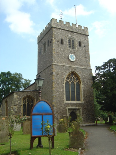
[edit]The Church of England parish church of Saint Mary has a flint and stone Norman tower and Tudor monuments. The tree-lined Village Road includes several old red brick houses with mature Wisteria on them, and has been used as a location in British films and television.
Southlands Manor is a Grade II listed building. Its entry on the English Heritage website states that it was built in the 16th century, with a variety of later changes including the addition of four chimney stacks in the early 17th-century.[3] Analysis of a sample of timbers from the main building and its associated barn have found that they were felled in the winters of 1472/3 and 1473/4, indicating that the relevant parts of the building were erected in 1474 or soon after.[4]
The Old Bakery, built in about C14, it is one of the earliest surviving buildings along the village High Street. It is located along what would have been medieval burgage plots. The plots were for laying out a town. Built for the Abbot of Westminster, probably on instructions by Nicholas de Littlington, for his reeve. One survey suggests a very precise date of building of 1367–68, although no dendrochronology has been undertaken. The building phases and outlay are complex, with much alteration. Prior to the 1950s demolition of the former E wing the building formed three cottages/shops.
Denham Film Studios were near the village and where famous films, including Brief Encounter and In Which We Serve were produced. The buildings were demolished in 1980 and the site re-landscaped as a business park and later as a site for luxury homes.[5]
Bosch has its UK head office in Denham.
The "Denham Massacre"
[edit]In 1870 Denham received national attention in what became known as the "Denham Massacre". A local blacksmith, Emmanuel Marshall and six of his family, were found bludgeoned to death with a sledgehammer in their cottage in the village. A homeless man named John Owen, who claimed Marshall owned him money, was convicted of the murders and hanged at Aylesbury Gaol.[6]
Development
[edit]- Denham Village, the original settlement
- Denham Garden Village, north of Denham Green Lane – built in the 1950s, renovated in 2006
- Denham Green grew up around the shops beside the railway station. Alexander Korda's Denham Film Studios (now demolished) used the Broadwater (Business) Park land between the junction of the road to Rickmansworth (A412) and Moor Hall Road towards Harefield
- New Denham is a linear part on the old Oxford Road north-west of Uxbridge, west of the Grand Union Canal
- Higher Denham is a locality on the site of a World War I army training and transit camp, placed to take advantage of the adjacent Denham Golf Club station. After the war, the camp land was sold off piecemeal for housing, following a similar trend all over Metro-land. Martin-Baker, manufacturers of aircraft ejector seats, have a small factory in Higher Denham.
- Tatling End is on the Oxford Road, west of the junction with the A412, at the top of the hill leading out of the Misbourne valley
- Tilehouse Lane forms the western boundary of the old Tile House and grounds, which were constructed in 1800 and fell into dereliction in the mid 20th Century. The site was purchased by BP who built the Durdent Court residential training and conference centre there in 1983. BP subsequently sold the facility and it is now the Denham Grove Hotel.
Transport
[edit]Denham railway station has direct services to London Marylebone and High Wycombe and limited services to Princes Risborough, Aylesbury and Banbury. Connecting services link to Birmingham Snow Hill, Stratford-upon-Avon and Kidderminster.
The 724 Green Line bus service links Harlow and Heathrow Airport—passing through St Albans, Watford, Rickmansworth, Denham and Uxbridge—and terminating at Heathrow Central bus station.
The 331 bus service between Uxbridge and Ruislip stations (operated by Metroline West for London Buses) calls at the Station Parade shops in Denham Green. The 581 circular bus service provides a link between the various areas of Denham and Uxbridge bus station. The Saturdays-only 582 service links the various Denhams with Iver, Slough and Windsor. The 101, 102 and 104 run through the outskirts of Denham.
Denham Aerodrome (ICAO: EGLD) is an operational general aviation aerodrome established in the early 1900s.[7] Sited on higher land to the north of the village, it is the base of many private and executive aircraft and helicopters with several hangars and a hard runway. In 1915, during the First World War, RAF Denham was established as a flying training school for flight cadets.
Schools
[edit]Denham Village School (formerly Denham Village Infant School, which originally had classes for Reception and Years 1 and 2), in Cheapside Lane, is the original school for Denham, and now has classes from Reception to Year 6.[8] The school building dates from 1832 and is Grade II listed.[9]
Denham Green E-ACT Primary Academy is located on Nightingale Way and opened in September 2013. Replacing the former Tilehouse Combined School, it is for children ages 4–11, and offers pre-school services. The school's current leadership team completed an Ofsted inspection shortly before converting to an academy. Ofsted noted that the school was a Good school with Outstanding features. The academy accepts all children from the Denham area (including Denham Village, Denham Green, Maple Cross, Harefield and North Uxbridge) who wish to attend the school.
Sports
[edit]- Denham contains the Buckinghamshire Golf Club and the Denham Golf Club.
- Denham Cricket Club, on Cheapside Lane, currently play in Morrant's Chiltern Cricket League.
- Denham United Football Club, on Tilehouse Lane, play in the High Wycombe Sunday Football Combination Division 1.
Demography
[edit]| Output area | Homes owned outright | Owned with a loan | Socially rented | Privately rented | Other | km2 roads | km2 water | km2 domestic gardens | km2 domestic buildings | km2 non-domestic buildings | Usual residents | km2 |
|---|---|---|---|---|---|---|---|---|---|---|---|---|
| Civil parish | 1125 | 1039 | 463 | 357 | 37 | 0.761 | 0.391 | 1.416 | 0.250 | 0.175 | 7139 | 16.02 |
Notable residents
[edit]- Raymond Baxter, BBC Television presenter, lived in Denham until 1978.[11]
- Mary Hayley Bell, English actress and writer, married to Sir John Mills, lived in Denham from 1975 until her death in 2005.
- Cilla Black, singer, entertainer and television personality had her main residence in Denham Green, bought with her late husband Bobby in the 1970s. In a burglary in 2002 £1 million worth of gems were stolen.[12]
- Sir George Bowyer, 5th Baronet, was born at Denham Court.[13]
- Brian Connolly, lead singer with 1970s glam rock band Sweet, lived at Denham until his death in 1997.[14]
- Jess Conrad, actor and singer, lived in Denham.[15]
- Edward Cooke, British politician and pamphleteer, was born in Denham.
- Dame Isobel Cripps, overseas aid organiser, was born in Denham.
- Paul Daniels, magician, lived in Denham.[16]
- Lt-Gen. Gerald Goodlake VC, British soldier and recipient of the Victoria Cross, lived and died at Savay Farm, close to Denham.
- Sir John Mills, film actor, was a resident of the village for many years, and is commemorated by a blue plaque on Hills House, his former residence by the church.[17]
- Sir Roger Moore, actor, lived in Sherwood House, Tilehouse Road, Denham.[18]
- Oswald Mosley, British politician and founder of the British Union of Fascists, lived at nearby Savay Farm with his wife, Diana Mosley.[19]
- Mike Oldfield, musician, lived in Tilehouse Lane, Denham, 1979–86.[20]
- Harry Saltzman, Canadian-born Hollywood producer who produced the James Bond films in the 1960s, lived most of his life in Denham.
- Norman Spencer, film producer, lived in Denham in his later life.[21]
- Robert Vansittart, 1st Baron Vansittart, senior British diplomat and Chief Diplomatic Adviser to the British Government in the 1920s and 1930s, lived in Denham Place until his death in 1957.
- Dennis Wise, former Wimbledon, Chelsea and England football player and manager, lives in Denham.[22]
Twinning
[edit]Twinned with Denham, Shark Bay, Western Australia
References
[edit]- ^ ONS, Census 2021 Parish Profiles
- ^ (Mawer & Stenton, 1925).
- ^ Historic England. "Southlands Manor (1332678)". National Heritage List for England. Retrieved 2 October 2015.
- ^ Muir, Andy (2012). Dendrochronological analysis of oak timbers from Southlands Manor and Barn, Denham, Buckinghamshire, England. Hungerford, Berkshire: Tree-Ring Services.
- ^ First homes go on sale at Denham Film Studios:£120m conversion of iconic site brings hundreds of new homes within a 20-minute commute of central London
- ^ "True crime in Bucks: The blacksmith family massacre". Bucks Free Press. 30 October 2020. Retrieved 2 February 2026.
- ^ "About Denham Aerodrome". Archived from the original on 24 May 2012.
- ^ "Denham Village School: About Us". Archived from the original on 5 September 2023. Retrieved 5 September 2023.
- ^ Historic England (23 July 1992). "Denham First School and Attahed Walls (1332453)". National Heritage List for England. Retrieved 21 August 2025.
- ^ "Local statistics – Office for National Statistics". ons.gov.uk.
- ^ "Obituary: Raymond Baxter". The Daily Telegraph. 16 September 2006. Retrieved 31 January 2012.
- ^ "Cilla Black £1m insurance blow". Evening Standard. 25 October 2003. Archived from the original on 18 September 2012. Retrieved 31 January 2012.
- ^ Burke, John; Burke, Sir John Bernard (1838). A genealogical and heraldic history of the extinct and dormant baronetcies of England. London: Scott, Webster, and Geary. p. 77. Retrieved 31 January 2012.
- ^ "The Sweet". British Music Experience. Retrieved 31 January 2012.
- ^ "Queen's Birthday Honours 2011: list in full". The Daily Telegraph. 11 June 2011. Retrieved 31 January 2012.
- ^ Russell, Rosalind (2 August 1997). "Bathing beauties". The Independent. Archived from the original on 2 August 2012. Retrieved 31 January 2012.
- ^ "Obituary: Sir John Mills". The Independent. 25 April 2005. Archived from the original on 30 November 2011. Retrieved 31 January 2012.
- ^ "Our story of the month: October 2006". roger-moore.com. Sir Roger Moore Official Site. Retrieved 1 February 2012.
- ^ Pugh, Martin. (2006). 'Hurrah for the Blackshirts': Fascists and Fascism in Britain between the wars (London: Pimlico), p. 302.
- ^ "Mike Oldfield posed in a field at his home in Denham, Buckinghamshire, England in January 1982". gettyimages.co.uk. Getty Images. 1 January 1982. Retrieved 1 February 2012.
- ^ Dunhill, Lawrence (26 August 2009). "Hollywood film producer takes French lessons in Iver Heath". Bucks Free Press. Retrieved 14 August 2024.
- ^ "WISED UP DENNIS IS MARRIED..." Daily Mirror. 19 June 2004.
External links
[edit]South Bucks (former district) | ||
|---|---|---|
| Towns (component areas and hamlets) |  | |
| Other civil parishes (component villages and hamlets) | ||
| Former districts and boroughs | ||
| Former constituencies | ||
| International | |
|---|---|
| National | |
| Geographic | |
| Other | |
Denham, Buckinghamshire
View on GrokipediaThe parish, which recorded a population of 8,180 in the 2021 census, encompasses the original village core along with modern developments and scattered hamlets, set amid wooded countryside traversed by the Colne and Misbourne rivers.[2][3] Its name derives from Old English "denu-hām," denoting a homestead in a valley, with the settlement documented as Deneham in the Domesday Book of 1086.[4] Key features include the 15th-century St Mary's Church with its surviving Norman tower and the Grand Union Canal's Denham Deep Lock, the deepest on the waterway at nearly 11 feet, which supports boating, walking, and local biodiversity in Denham Country Park.[3][5] The area retains a semi-rural character with golf clubs, marinas, and historic estates amid commuter accessibility via rail and road links.[1]
History
Origins and Medieval Period
Archaeological evidence indicates sparse prehistoric occupation in Denham, with flint artefacts dating from the Lower Palaeolithic (hand axes at Normer Hill) to the Bronze Age (field systems and ring ditches at Lea Quarry) found along the Misbourne and Colne valleys.[6] Roman activity remains limited, comprising isolated metalwork near St Mary's Church and potential field systems, suggesting peripheral use rather than dense settlement.[6] The place-name "Deneham," deriving from Old English for "homestead in a valley," points to Saxon-era establishment as a small agrarian community, though direct archaeological confirmation is absent.[6] Denham appears in the Domesday Book of 1086 as a manor held by Westminster Abbey, encompassing 10 hides with 18 households—15 villagers and 3 smallholders—supporting an estimated population of around 90.[7] [6] Resources included 12 ploughlands (2 lord's teams, 7 men's), meadows sufficient for 12 ploughs, woodland for 300 pigs, 2 mills valued at 7 shillings, and 3 fisheries, underscoring a self-sufficient economy centered on arable farming, milling, and woodland exploitation; the manor's value had declined to £7 from £10 in 1066.[7] Feudal obligations tied tenants to the abbey, with pre-Conquest ownership possibly granted via a charter attributed to Edward the Confessor, though its authenticity is questioned.[8] During the medieval period, Denham's structure coalesced around St Mary's Church—featuring a 12th-century precursor with later 14th- and 15th-century expansions—and a triangular village green along Village Road, flanked by long tenement plots indicative of nucleated settlement.[6] The manor split circa 1150–1160 into superior Denham (retained by the abbey) and sub-manor Denham Durdent, fostering localized agrarian pursuits including water mills on the Misbourne and pottery production from 12th–14th-century kilns.[6] [8] A market and fair were granted in 1227, though their viability remains uncertain, reflecting attempts to bolster the feudal economy amid serfdom and customary rents documented in 14th–15th-century court rolls.[6] [8]Industrial and Cinematic Era
In the early 1930s, Hungarian-born producer Alexander Korda, through his London Film Productions company founded in 1932, sought to elevate British cinema by constructing a state-of-the-art facility to compete with Hollywood's dominance. Construction of Denham Film Studios began in late 1935 on a 165-acre site near Denham village in Buckinghamshire, designed by American architect Jack Okey to include multiple sound stages, laboratories, and backlots. The studios officially opened in May 1936 as Britain's largest and most advanced production complex, financed in part by the Prudential Assurance Company, with Korda envisioning it as "Hollywood U.K." to foster prestige British films.[9][10][11] Denham quickly became a hub for pre-World War II British filmmaking, producing key titles such as Rembrandt (1936), directed by Korda himself, A Yank at Oxford (1937), and The Four Feathers (1939), which showcased technical innovations like large-scale sets and early color processes. These efforts contributed to a surge in domestic output, with the studios hosting multiple simultaneous productions and attracting international talent, though yields were limited by the era's quota system favoring British content over imports. Despite ambitions, operational challenges emerged early, including an inefficient layout that hindered workflow efficiency compared to streamlined Hollywood facilities, exacerbating costs in a market where American competition dominated global distribution.[10][11][12] During World War II, Denham maintained partial production continuity, unlike rival Pinewood Studios, which was requisitioned by the military for storage and training; filmmakers reportedly preferred Denham's setup, allowing films like The Prime Minister (1941) and some Allied propaganda efforts to proceed amid blackouts and resource shortages. Government emergency powers redirected studio spaces nationwide for wartime needs, but Denham's operations adapted, supporting both British and limited American projects through 1943. This resilience stemmed from Korda's connections, including ties to Winston Churchill, yet underscored broader inefficiencies, as production volumes lagged behind peacetime peaks due to material rationing and labor diversions.[13][11][14] The studios provided a significant economic impetus to Denham's rural economy, employing hundreds in technical, craft, and support roles that drew workers from surrounding villages and London, transforming the area from agrarian isolation to a cinematic outpost with ancillary businesses like prop suppliers and housing for crew. This influx boosted local commerce and infrastructure demands, evident in expanded transport links, though the benefits were unevenly distributed and vulnerable to Hollywood's superior financing and marketing, which siphoned talent and audiences. Korda's vision yielded prestige but highlighted causal limits: without integrated vertical control akin to major U.S. studios, Denham's scale amplified overheads without commensurate market share gains.[15][12][11]Post-War Expansion and Modern Era
Following the end of the Second World War, Denham Film Studios, which had been requisitioned for military use during the conflict, ceased operations as a production facility in 1952 amid post-war economic challenges in the British film industry.[13] The site's infrastructure, including sound stages and backlots, stood largely unused for decades until 1981, when the remaining buildings were demolished to facilitate redevelopment into Broadwater Park, a business park that attracted corporate tenants such as the UK headquarters of Robert Bosch Ltd.[4] Denham Aerodrome, surplus to Ministry of Defence requirements after the war, transitioned into a hub for general aviation activities, supporting private flying clubs and training operations rather than military expansion.[16] In 1975, the Medminster Group, which managed several UK airfields, undertook rationalizations at Denham to streamline operations, shifting focus toward larger sites like Biggin Hill while retaining Denham's role in civil aviation.[17] Constrained by its location within the Metropolitan Green Belt and proximity to the M25 motorway, Denham has experienced limited infrastructural growth in recent decades, with development policies emphasizing preservation of open spaces amid regional housing pressures.[18] The Denham Parish Neighbourhood Plan, adopted for the period 2020–2036, prioritizes sustainable infill housing on consented sites like the former Smiths nursery, rejecting broader Green Belt releases due to incompatibility with national planning frameworks that restrict inappropriate development in protected areas.[19] This approach reflects empirical assessments finding no additional suitable sites outside the Green Belt, balancing local needs against environmental safeguards.Geography and Environment
Location and Topography
Denham civil parish lies approximately 17 miles (27 km) northwest of central London in the Colne Valley, at the southeastern edge of Buckinghamshire's unitary authority area.[20] The parish occupies a position within the M25 orbital motorway and borders Gerrards Cross to the west, with its eastern boundary delineated by the River Colne.[18][21] The parish boundaries encompass distinct settlements such as Denham Village, Denham Green, Higher Denham, New Denham, and Tatling End.[22] It maintains proximity to the Chiltern Hills Area of Outstanding Natural Beauty, situated at the eastern fringe of the Chilterns.[22] Topographically, Denham features a shallow, flat-bottomed valley formed by the Colne and Misbourne rivers, with lower elevations in the village core along the River Misbourne.[23] Higher terrain rises to the north, including the site of Denham Aerodrome at 249 feet (76 meters) above mean sea level.[24] Geologically, the area overlies mudstone bedrock, with chalk in the Misbourne Valley and around Denham, capped by superficial deposits of sands, silts, and gravels; soils comprise seasonally wet deep loams south of the Misbourne, conducive to historical agriculture.[23][6] Southward, elevation decreases amid a transition to London Clay mudstone, yielding low-lying floodplain characteristics.[25]Green Spaces and Aerodrome Influence
Denham lies within the Colne Valley Regional Park, a 43-square-mile area characterized by a mosaic of farmland, woodland, watercourses exceeding 200 kilometers in length, and over 70 lakes that support varied ecological functions.[26] Denham Country Park, situated along the River Colne, Misbourne, and Frays rivers, exemplifies these features with its riverine habitats fostering a mix of resident and migratory wildlife, including bird species adapted to wetland edges.[27] The Grand Union Canal, traversing the vicinity, contributes to linear corridors for aquatic and riparian biodiversity, with empirical surveys noting enhanced connectivity for species such as otters and water voles in restored sections.[26] Local meadows and semi-improved grasslands around Denham provide foraging grounds for invertebrates and pollinators, as observed in countryside walks that traverse these open areas adjacent to arable fields.[28] These green spaces function as buffers in the landscape, mitigating flood risks through natural drainage via the Colne Valley's floodplain meadows, which retain water during high flows based on hydrological data from the regional park's monitoring.[29] Denham Aerodrome originated as a World War I training site in 1915, when the Royal Flying Corps established it for flight cadet instruction on former agricultural land, marking an early shift from pastoral use to aviation-related infrastructure.[30] By the interwar period, this evolved into a licensed private airfield, embedding aviation within the Green Belt where development is restricted to preserve landscape openness and prevent urban sprawl.[31] The aerodrome's 50-hectare footprint influences adjacent land use by designating safeguarded zones that limit incompatible constructions, allowing grassland and scrub to persist alongside runways and supporting ground-nesting birds amid operational constraints.[18] Planning documents note its role in maintaining Green Belt integrity, with flight path corridors overhead imposing height restrictions on nearby vegetation and buildings to ensure safe aviation envelopes without altering core ecological parcels.[32]Governance and Community
Local Administration
Denham functions as a civil parish within Buckinghamshire, governed at the upper tier by Buckinghamshire Council, which assumed unitary authority responsibilities on 1 April 2020, replacing the former Buckinghamshire County Council and the district councils including South Bucks.[33] The parish council maintains autonomy over localized decision-making, including community services, maintenance of public spaces, and input on planning applications, while aligning with the unitary council's broader policies on waste, highways, and education.[1] Denham Parish Council, based at the Village Hall on Village Road, comprises elected councillors who serve four-year terms and represent resident interests in areas such as allotments, playgrounds, and footpath upkeep.[34] [35] The council's operations emphasize resident engagement, evidenced by the preparation and adoption of the Denham Parish Neighbourhood Plan (2020–2036), which was designated by the former South Bucks District Council and focuses on sustainable development controls driven by local priorities like preserving green spaces amid housing pressures.[19] [36] This plan, submitted following public consultations, allocates sites for limited housing growth while prioritizing infrastructure safeguards, reflecting a community-led approach to balancing expansion with existing amenities. Fiscal management at the parish level prioritizes essential services, with council meetings addressing budget allocations for maintenance and events, though detailed public budget figures and election turnout data for parish polls remain limited in accessible records beyond unitary ward by-elections, such as the 2023 Denham ward contest.[37] [38] Integration with Buckinghamshire Council ensures coordinated planning enforcement, where parish recommendations influence decisions on major developments without overriding unitary oversight.[39]International Twinning and Partnerships
Denham is twinned with the town of Denham in the Shire of Shark Bay, Western Australia, a relationship formalized on 1 January 1994.[40] The initiative originated from a local resident seeking a counterpart sharing the village's name, leading to celebrations at Blacksmiths Pond in Denham, Buckinghamshire.[41][40] This arrangement emphasizes symbolic ties rather than operational partnerships, with no documented evidence of formal exchange programs, cultural events, or joint initiatives beyond the initial establishment.[41] Assessments of town twinning generally highlight limited tangible outcomes, such as negligible economic collaboration across vast distances—over 17,000 kilometers separating the locations—and primarily nominal community goodwill. In Denham's case, the partnership appears dormant in practice, with no public records of reciprocal visits or sustained activities reported by local authorities. Any associated costs to taxpayers remain undocumented and likely minimal, as such links are typically managed by volunteers without significant council expenditure.[41][42]Economy and Development
Historical Economic Foundations
The medieval economy of Denham centered on agriculture and related activities, as recorded in the Domesday Book of 1086, which documented the manor holding 13 hides of land, supporting 15 villagers and 3 smallholders engaged in mixed farming, with capacity for additional ploughs indicating arable potential.[22] Woodland sustained 300 pigs annually, while fisheries generated 3 shillings in value, underscoring a diversified rural base that included grazing pastures, meadows, woods, and milling.[22] Two mills, powered by the Rivers Colne and Misbourne, processed corn and were integral to manorial operations by 1086, later known as Town Mill and Denham Mill.[43] Manorial records from the principal estates of Denham and Denham Durdent, granted to Westminster Abbey in 1065 and sub-infeudated in the 12th century, reveal tenant farming as the dominant structure, with burgage plots allocating narrow strips for vegetable cultivation to support local households.[22] Court rolls dating to 1333 detail tenant obligations, reflecting a system where lords like the Bowyers at Denham Court controlled significant holdings, including moated sites like The Savay.[6] Enclosure processes by the early 16th century privatized common lands, shifting from open-field systems to consolidated farms; by 1749, 97% of land was held by just 1.6% of the population across 13 major landowners.[43] This agrarian framework persisted into the 19th century, with 19 tenant-operated farms documented by 1801, such as Savay Farm (445 acres) and Denham Court Farm (300 acres), providing livelihoods through crop yields and labor for estate maintenance.[43] The early 20th century marked a pivot from agriculture toward light industry, exemplified by the establishment of Denham Film Studios in 1936 on a 193-acre former estate site, which capitalized on underutilized farmland amid broader agrarian declines.[44] Founded by Alexander Korda under London Film Productions, the facility became Britain's largest and most advanced studio at the time, employing approximately 2,000 workers across specialized departments including 14 cutting rooms, machine shops, foundries, and woodworking mills. This influx supported local trades and services, transitioning Denham's economic base from seasonal farming to steady studio operations, though the site's selection reflected national trends in repurposing rural land rather than inherent village prosperity.[12]Contemporary Growth and Challenges
Since the mid-20th century, Denham has evolved into a commuter-oriented economy, with strong rail connections via the Chiltern Main Line to London Marylebone enabling residents to access white-collar employment in the capital.[36] Local growth has been supported by the redevelopment of the former Denham Film Studios site—operational from 1936 to 1952—into Broadwater Business Park, which now hosts companies such as the UK headquarters of Robert Bosch and provides diverse employment opportunities.[9] Key strategic employers include Martin-Baker, a manufacturer of aircraft ejection seats, contributing to aviation support sectors bolstered by the adjacent Denham Aerodrome.[36] The Denham Parish Neighbourhood Plan (2020–2036) outlines controlled expansion, proposing up to 16,000 square metres of office space, a hotel, and 500 square metres of retail north of Denham Roundabout to foster job growth while protecting existing economic sites like Broadwater Park and Martin-Baker from non-employment uses.[36] Housing development is targeted at 491 dwellings by 2036, comprising 372 already built or committed, 59 from identified sites, and 60 from anticipated windfalls, emphasizing brownfield reuse to meet needs without encroaching on green spaces.[36] This aligns with Buckinghamshire's broader affluence, where the county ranks as England's least deprived local enterprise partnership area with an Index of Multiple Deprivation score of 10.1, alongside high employment rates of 81.2% for working-age residents.[45][46] Growth faces constraints from Denham's green belt designation, with policies insetting villages like Denham Village and Higher Denham while retaining current boundaries to preserve openness and prevent urban sprawl.[36] Infrastructure limitations, including congestion on the M25 and local routes like Oxford Road exacerbated by heavy goods vehicles and proximity to HS2 construction, hinder further expansion and accessibility.[36] These factors contribute to housing affordability pressures in an otherwise prosperous area, where high out-commuting and development caps limit local job absorption despite sectors like aviation and logistics benefiting from Heathrow's influence.[47]Infrastructure and Transport
Road and Rail Connectivity
Denham benefits from strategic road links via the A412, a primary route shadowing the northwestern section of the M25 motorway between Slough and Watford, enabling efficient access to central London and Heathrow Airport.[48] The A412 connects directly to M25 Junction 17 at Maple Cross via the A405 North Orbital Road, where traffic flows are monitored for congestion, as evidenced by frequent reports of heavier-than-normal volumes approaching from the A412 Denham Way.[49][50] Rail connectivity is provided by two stations on the Chiltern Main Line: Denham railway station, constructed in 1905 as part of the Great Western Railway's extension, and Denham Golf Club station nearby.[51][6] Chiltern Railways operates hourly services from these stations to London Marylebone, with journey times averaging 25-30 minutes and fastest services as quick as 19 minutes.[52][53] Gerrards Cross station, approximately 6 minutes by train from Denham, offers additional peak-hour options on the same line.[54] Historical improvements to road infrastructure include the establishment of the A412 North Orbital Road in 1930, which initially bypassed sections around Denham to manage early motor traffic growth.[55] Post-war developments, such as the M40 motorway's Gerrards Cross bypass completed in 1973 linking to Denham at Junction 1, diverted heavy through-traffic from village routes, alleviating congestion at Denham Roundabout, which was enlarged to accommodate the motorway's integration.[16] Further upgrades at Denham Interchange, planned from 1964 and refined in 1966, enhanced junction capacity for intersecting A40 and A413 traffic.[56]Aviation Facilities
Denham Aerodrome, designated with the ICAO code EGLD, serves as a general aviation facility primarily supporting flight training, private operations, aircraft maintenance, and aerial work such as filming.[57][58] The aerodrome features two runways: the main paved runway 06/24 measuring 775 meters (2,543 feet) in length, aligned with prevailing southwest winds, and a secondary grass runway 12/30.[59][60] Its elevation above mean sea level stands at 249 feet (76 meters), with operations adhering to UK Civil Aviation Authority (CAA) licensing standards established for private use on 19 May 1938.[61][62] Initial flying activities at the site, originally known as Hawksridge, trace to military surveys and early aviation experiments from the late 19th century, with confirmed airfield operations commencing around December 1916 for Royal Flying Corps training during the First World War.[57][30] Post-World War II, the aerodrome transitioned to civilian control under private operators, expanding facilities including hangars for aircraft storage and maintenance by the 1970s, when applications were filed to retain key structures like Hangar M amid development pressures.[63] Further growth included the establishment of flying schools, such as the 1962 launch of a British Executive Air Services offshoot offering aeroplane and helicopter training.[64] By 1985, infrastructure enhancements continued with the opening of a new Air Training Corps building on 19 September, supporting squadron activities.[65] Operational constraints emphasize safety and noise mitigation, given the aerodrome's location near controlled airspace including RAF Northolt (4 nautical miles southeast) and London Heathrow.[66] Circuit heights are limited to a maximum of 750 feet above ground level to avoid Northolt's airspace, with pilots required to maintain visual contact and adhere to a comparatively small circuit pattern designed to bypass noise-sensitive areas below.[67] Departures and arrivals must comply with CAA regulations prohibiting low flying near persons or structures, alongside broader prohibitions on operations within specified proximities to active military or major commercial airfields like Heathrow. The CAA oversees aerodrome safety through mandatory assessments of mitigations for capacity, noise, and operational risks, ensuring no exceedance of licensed parameters.[68]Demographics
Population Trends
The population of Denham civil parish has exhibited long-term growth, particularly accelerating in the 20th century amid suburban expansion linked to its proximity to London. The 1801 census recorded 796 inhabitants living in 164 families across 150 houses.[69] Subsequent 19th-century censuses showed modest fluctuations, with figures rising to a peak of 1,264 in 1841 before stabilizing around 1,100–1,200 by 1901.[69]| Census Year | Population |
|---|---|
| 1801 | 796 |
| 1811 | 1,000 |
| 1821 | 1,189 |
| 1831 | 1,169 |
| 1841 | 1,264 |
| 1851 | 1,062 |
| 1861 | 1,068 |
| 1871 | 1,234 |
| 1881 | 1,254 |
| 1891 | 1,242 |
| 1901 | 1,146 |