

Community hub
Recent from talks
Contribute something
Nothing was collected or created yet.
Inman Park
View on Wikipedia
Inman Park Historic District[1] | |
 Welcome Sign in Inman Park | |
   | |
| Location | Roughly bounded by Freedom Parkway, DeKalb and Lake Aves. (original) and Roughly bounded by Lake, Hurt, and DeKalb Aves., and Krog St. (increase), Atlanta, Georgia |
|---|---|
| Coordinates | 33°45′20″N 84°21′34″W / 33.75556°N 84.35944°W |
| Built | 1889 |
| Architect | Multiple |
| Architectural style | Queen Anne, Shingle Style (original); Queen Anne, Stick/Eastlake, Colonial Revival, Shotgun, Bungalow, Arts & Crafts, Romanesque Revival, Prairie Style, Arts & Crafts Revival, et al. (increase) |
| NRHP reference No. | 73000621 and 01000973[2] |
| Added to NRHP | July 23, 1973 (original) September 16, 2001 (increase) |
Inman Park is an intown neighborhood on the east side of Atlanta, Georgia, and its first planned suburb. It was named for Samuel M. Inman.
History
[edit]Today's neighborhood of Inman Park includes areas that were originally designated:
- Inman Park proper (today the Inman Park Historic District)
- Moreland Park (today the Inman Park-Moreland Historic District)
- part of Copenhill Park (properties on Atlantis, the south side of Highland, and the north sides of Sinclair and a block of Austin)
- former industrial areas on the western side, now mixed-use developments including Inman Park Village and North Highland Steel
The area was part of the battlefield in the Battle of Atlanta in 1864.
Atlanta's first streetcar suburb
[edit]Inman Park (proper) was planned in the late 1880s by Joel Hurt, a civil engineer and real-estate developer who intended to create a rural oasis connected to the city by the first of Atlanta's electric streetcar lines, along Edgewood Avenue. The East Atlanta Land Company acquired and developed more than 130 acres east of the city and Hurt named the new suburb for his friend and business associate, Samuel M. Inman. Joseph Forsyth Johnson was hired as landscape designer for Inman Park who included curvilinear street designs and liberal usage of open spaces in his planning.[3][4][5]


The Atlanta Constitution in 1896 grandly described Inman Park:
High up above the city, where the purest breezes and the brightest sunshine drove away the germs of disease, and where nature had lavished her best gifts, the gentlemen who conceived the thought of Inman Park found the locality above all others which they desired. It was to be a place of homes, of pretty homes, green lawns, and desirable inhabitants. And all save those who would make desirable residents have been excluded. ... It's the prettiest, highest, healthiest and most desirable locality I ever saw. Everybody is friendly and neighborly. ... And as far as accessibility it ranks second to no residence portion of the city. We have three car lines and frequent schedules.[6]
Like new developments throughout the United States at the time, but in stark contrast to the attitudes prevalent in the neighborhood today, Inman Park was conceived of and promoted as a segregated community.
Moreland Park was by contrast developed as a more traditional, incremental building of sub-divisions as opposed to the grand plan for Inman Park proper.
Decline
[edit]
The arrival of the automobile allowed upper class Atlantans to live in suburbs farther north from downtown workplaces, such as Morningside and what is now considered Buckhead. Inman Park became less fashionable and the exuberant Victorian architecture came to seem dated. The mansions came to be subdivided into apartments.
Similar to other intown neighborhoods such as Virginia Highland, Inman Park fell to blight during the white middle and upper class exodus to the northern suburbs in the 1950s and 1960s, and was:
an economically depressed neighborhood of mostly blue-collar white folks, elderly couples who could not afford to move out and families on disability and welfare. They lived in rented bungalows or big houses chopped up into tiny roach-infested apartments.[7]
Atlanta's first intown neighborhood to gentrify
[edit]Driving through the neighborhood on his way to appraise stained glass windows in the doomed home of Judge Durwood T. Pye on Poplar Circle, Robert Griggs was smitten by the extraordinary architecture of the Beath-Dickey House, then a dilapidated multi-unit rental property. He and his partner, Robert Aiken, bought the house[when?] and restored it to a single-family dwelling. They were followed by others who restored homes; founded[when?] Inman Park Restoration, the neighborhood association; and created[when?] a neighborhood newsletter, a garden club to rehabilitate public spaces, and a pre-school.[8] To publicize the progress they were making, they began[when?] a Tour of Homes with a small festival, which has grown into the hugely popular Inman Park Festival, held each spring.
Freeway revolt against I-485
[edit]During this same period, there was an intense fight against the I-485 freeway which was to be built through the neighborhood, although many properties in Inman Park, as well as the entire neighboring neighborhood of Copenhill, were torn down in preparation for freeway construction.
Inman Park today
[edit]After decades of restoration and renewal, Inman Park is now regarded as a highly desirable intown neighborhood with a mixture of rental and owner-occupied houses and condominiums. Built up as it was over decades, the neighborhood housing now ranges from tiny mill town shotguns to the Victorian mansions of the original development, intermixed with bungalows of all sizes built during the first three decades of the 20th century. Like its housing, the makeup of Inman Park has changed since its inception, with a population that is 25% non-white and of varying economic levels—although increasing housing prices are beginning to force more economic homogeneity.[9] Since the beginning of its renewal, inclusivity and a strong sense of community have distinguished Inman Park. The neighborhood association has always welcomed renters and homeowners alike, with nominal annual dues, while the Inman Park Festival, which attracts tens of thousands of visitors every spring, brings residents together to produce the largest all-volunteer festival in Georgia. The Festival's centerpiece is the Tour of Homes, which showcases the wide variety of sizes and types of residences in the neighborhood.
Former industrial areas on the west side of the neighborhood have been redeveloped into mixed-use complexes. The former General Pipe and Foundry site is now North Highland Steel and the Mead paper plant site is now Inman Park Village. In the early 1990s the former Atlanta Stove Works was transformed by swapping out two letters of its name and became the Atlanta Stage Works, a film and media production center that eventually housed the early Tyler Perry film studios and the National AIDS Quilt. In 2015 it was converted into a mixed-use office and restaurant space, to be added to the space across Krog Street to form the Krog Street Market.
Geography
[edit]Inman Park is bordered by:[10]
- the BeltLine Eastside Trail on the west, across which lies the Old Fourth Ward
- Freedom Parkway on the north, across which lies Poncey-Highland
- Moreland Avenue on the east, across which lies Candler Park
- DeKalb Avenue on the south, across which lie Cabbagetown and Reynoldstown
Little Five Points district is located where Inman Park and Candler Park meet at Moreland Avenue and Euclid/McClendon.[10]
Architecture
[edit]-

-
 Victorian House with late 20th Century adornments added before historic zoning
 -
 Four-Square with Greek Revival columns added in 1970s (before historic zoning)
 -
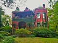 "The Castle" Romanesque Revival house
 -

-

-
 Late 20th Century Arts & Crafts Revival houses
 -
 Trolley Barn
 -
 Springvale Park
 -


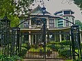
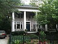
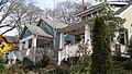
Inman Park contains Atlanta's best collection of residential architecture from the late 19th and early 20th centuries. Styles include Queen Anne, high-style Italianate and Romanesque mansion as well as smaller bungalows, shotguns, and foursquares. Inman Park was Atlanta's first example of a garden suburb, with great attention paid to street layout, parks and other public space, and would inspire other Atlanta garden suburbs such as the Frederick Law Olmsted-designed Druid Hills.
There are two historic districts within the Inman Park neighborhoods: the Inman Park historic district, and the Inman Park-Moreland Historic District, originally the separate suburb of Moreland Park.[11]
Notable houses include:
Other points of interest
[edit]- The Krog Street Tunnel under the CSX Railroad connects Inman Park with Cabbagetown and is famous for street art.
- Krog Street Market is a gourmet food hall
- Edgewood Avenue in both Inman Park and Old Fourth Ward is a restaurant street that has been gaining acclaim especially since 2013.
- Highland Avenue connects Inman Park to the Poncey Highland and Virginia Highland neighborhoods. The Highland Avenue corridor offers dozens of local restaurants and shops.
- St. Hilda's was built in 1939 as a Baptist church, and since 1978 has been a parish of the Anglican Catholic Church.
Parks
[edit]Parks in Inman Park include Springvale Park, a pet project of Joel Hurt and designed by the Olmsted Brothers.[12] Part of Freedom Park lies in the neighborhood, which the BeltLine trail also borders. There are also smaller parks: Delta Park, Inman Park, the park in Inman Park Village, and the Bass Recreation Center.
Government
[edit]Inman Park is in NPU N. Neighbors participate in the Inman Park Neighborhood Association (IPNA).[13]
Education
[edit]Inman Park residents are served by Atlanta Public Schools.
Zoned schools include:
Transportation
[edit]MARTA runs bus service and rail service. The Inman Park / Reynoldstown MARTA station is located at the south end of the neighborhood.
References
[edit]- ^ The original NRHP listing was as "Inman Park" but the boundary increase renamed it to "Inman Park Historic District" in the NRHP.
- ^ "National Register Information System". National Register of Historic Places. National Park Service. March 13, 2009.
- ^ Bazemore, Ted (September 12, 2007). "Inman Park". The New Georgia Encyclopedia. Archived from the original on February 1, 2013. Retrieved December 27, 2010.
- ^ "Bruce Forsyth". Who do you think you are?. BBC. Retrieved December 28, 2010.
- ^ Joseph Forsyth Johnson was the author of The Natural Principles of Landscape Gardening; or, The adornment of land for perpetual beauty. Belfast: Archer, 1874
- ^ "Homes at the Park: Beautiful residences that make Inman Park an ideal home place", Atlanta Constitution, 1896-03-26
- ^ Communications, Emmis (October 1, 2005). "Atlanta Magazine". Emmis Communications. Retrieved April 16, 2018 – via Google Books.
- ^ Marr, Christine V.; Jones, Sharon Foster (2008). Inman Park. Charleston, S.C.: Arcadia Pub. p. 101. ISBN 978-0-7385-6731-0.
- ^ "Race and Ethnicity in Atlanta-Inman Park, Atlanta, Georgia (Neighborhood)". Statisticalatlas.com. Retrieved August 26, 2015.
- ^ a b Google Maps
- ^ "Inman Park--Moreland Historic District--Atlanta: A National Register of Historic Places Travel Itinerary". Nps.gov. Archived from the original on October 13, 2008. Retrieved April 16, 2018.
- ^ "Parks", Inman Park association website Archived 2014-08-21 at the Wayback Machine
- ^ Inman Park Neighbors Association site Archived 2014-08-21 at the Wayback Machine
External links
[edit]- Inman Park Neighborhood Association
- Atlanta City Council resolution (2002) to expand the historic district, contains detailed information about Inman Park history and architecture
- New Georgia Encyclopedia Archived 2013-02-01 at the Wayback Machine
- Sketches of prominent Inman Park homes, 1895
- Atlanta, Georgia, a National Park Service Discover Our Shared Heritage Travel Itinerary

Inman Park
View on GrokipediaHistory
Origins as Atlanta's First Planned Suburb
Inman Park originated in the late 1880s as Atlanta's first planned garden suburb, developed by civil engineer and real-estate developer Joel Hurt through his East Atlanta Land Company, which he established in 1886 to acquire over 130 acres of land east of the city center.[4] Hurt named the suburb Inman Park after his business associate and friend Samuel M. Inman, a prominent cotton merchant, reflecting the collaborative financial and planning efforts that underpinned the project.[1] The development emphasized a rural oasis for affluent residents, featuring curvilinear street designs, liberal greenspaces, wide tree-lined boulevards like Edgewood Avenue (opened in September 1888 and privately funded), and a 10-acre centerpiece park with a lake known as Springvale Park.[1] To facilitate access from downtown Atlanta, Hurt formed the Atlanta and Edgewood Street Railway Company in 1886, introducing the city's first electric streetcar line along Edgewood Avenue in August 1889 with a 5-cent fare, making Inman Park Atlanta's inaugural electric trolley suburb and enabling efficient commuting for prospective homeowners.[4] The planning drew inspiration from emerging garden suburb models, prioritizing integration of natural elements such as ponds and topography-following streets to blend residential living with landscape aesthetics, as evidenced by the hiring of landscape designer James Forsyth Johnson.[1] Public lot sales commenced in 1889 and continued through 1896, spurring a construction boom of primarily Queen Anne-style homes from 1889 into the early 1900s, which attracted wealthy buyers seeking an escape from urban density while remaining connected via modern transit.[1]Economic Decline and Urban Blight
Following World War II, Inman Park experienced accelerated economic stagnation as Atlanta's residents increasingly favored automobile-dependent suburbs offering larger lots and modern amenities over the neighborhood's older, streetcar-era housing stock. This shift mirrored broader patterns in Atlanta, where the white population declined by over 60,000 between 1960 and 1970 amid suburban migration, contributing to intown vacancy and disinvestment.[5] Competition from emerging areas like Buckhead and Druid Hills, facilitated by expanded road networks, reduced demand for Inman Park properties, leading to stagnant lot sales that had already slowed by the early 1900s.[1] By the 1950s, many of Inman Park's grand Victorian homes were acquired by absentee landlords and subdivided into rooming houses or multi-family rentals, signaling falling property values and physical deterioration as maintenance lagged. The neighborhood's population exodus intensified in the 1960s, with middle- and upper-class flight to northern suburbs exacerbating urban blight, including vacant lots and crumbling structures amid rising crime and poverty.[6] [7] These market-driven dynamics, rather than isolated policy failures, transitioned Inman Park toward low-income occupancy, setting conditions for later private-led revival without reliance on federal urban renewal programs that displaced residents elsewhere in Atlanta.[8]Initial Gentrification and Urban Pioneer Efforts
In the late 1960s, interior designer Robert Griggs purchased a dilapidated Queen Anne-style Victorian house on Euclid Avenue in Inman Park for restoration, marking the inception of the neighborhood's revival through individual initiative.[1] This act attracted "urban pioneers"—primarily young professionals seeking affordable, historic urban housing—who began acquiring and rehabilitating blighted properties amid widespread neglect and subdivision into multi-family units.[9] Unlike government-subsidized urban renewal projects that often displaced communities elsewhere, Inman Park's early gentrification was propelled by private entrepreneurship, with buyers leveraging low acquisition costs to restore architectural integrity and capitalize on proximity to downtown Atlanta.[1] By 1970, these efforts coalesced with the formation of Inman Park Restoration Incorporated (IPR), a nonprofit community organization that coordinated cleanups, advocated for zoning reforms, and fostered resident buy-in to stabilize the area.[9] IPR successfully lobbied for a shift to low-density residential zoning by 1972, enabling dozens of houses to be restored from rooming-house conditions back to single-family use, which reduced the total number of housing units by approximately 400 between 1970 and 1980 as illegal divisions were eliminated.[1][9] The neighborhood's inclusion on the National Register of Historic Places in 1973 further incentivized preservation, signaling market demand for authentic Victorian-era living over suburban sprawl.[1] Early purchases exemplified the low entry barriers driving this wave: homes sold for as little as $5,000 to $23,000 in the early 1970s, with examples including a $20,000 acquisition in 1971 requiring only an $800 down payment.[10] These investments yielded substantial appreciation by the late 1970s and 1980s, as restored properties commanded premium prices reflective of rising demand, though exact figures varied; the trend stabilized the neighborhood by attracting committed owners rather than transient renters.[9] Crime and poverty, prevalent amid prior blight, declined as community-led watches and physical improvements enhanced security and cohesion, demonstrating causal links between private restoration and measurable urban recovery.[1][9] This bottom-up approach contrasted sharply with top-down failures in other cities, where bureaucratic interventions often exacerbated decline, underscoring the efficacy of market-driven signals in reviving decaying inner-city fabric.[1]Freeway Revolt Against I-485
In the mid-1960s, the Georgia Department of Transportation announced plans for Interstate 485 (I-485), a proposed east-west highway designed to cut through Atlanta's intown eastern neighborhoods, including Inman Park, Morningside, and Virginia-Highland, as part of a broader effort to expand the interstate system amid post-World War II urban growth pressures.[11][12] The route would have traversed densely settled residential areas, necessitating widespread eminent domain actions to acquire private properties and effectively bisecting established communities, with projections indicating demolition of hundreds of homes and businesses in the path.[13][14] Local residents, facing direct threats to their property rights and the cohesion of their neighborhoods, organized grassroots coalitions such as CAUTION, Inc. (Citizens Against the Unnecessary Interstate Near Town), which linked activists from Inman Park with those in adjacent areas like Candler Park and Poncey-Highland to mount a multifaceted resistance campaign.[15][16] Drawing on principles of individual liberty and skepticism toward top-down urban planning that prioritized vehicular throughput over lived community structures, opponents pursued legal injunctions, public demonstrations, and legislative advocacy, highlighting how the project echoed earlier urban renewal displacements that had already eroded Atlanta's social fabric without commensurate traffic benefits.[17][10] The opposition endured for over three decades, outlasting initial halts under Governor Jimmy Carter in the 1970s and later revivals pitched as the narrower "Presidential Parkway" with his post-presidential endorsement, which critics viewed as influenced by personal interests tied to the nearby Carter Presidential Library.[18][17] Atlanta City Council voted 10-4 in February 1985 to block further advancement, though Mayor Andrew Young's veto prolonged the fight until a 1991 compromise agreement definitively canceled the full interstate.[17][15] This victory redirected the preserved corridor toward the limited-access Freedom Parkway—a scenic, low-impact boulevard integrated with green space—rather than a disruptive elevated or depressed highway, thereby safeguarding Inman Park's Victorian-era housing stock and street grid from fragmentation that comparable projects inflicted on other U.S. cities.[13][11] The outcome underscored the causal efficacy of localized, persistent civic action in countering bureaucratic momentum, as evidenced by the sustained residential stability and avoidance of blight in the affected zones post-1991, contrasting with the socioeconomic disruptions from built interstates elsewhere in Atlanta.[8][10]Post-Revitalization Developments
Following the successful opposition to Interstate 485 in the 1970s, Inman Park experienced sustained private-led restoration efforts into the 1990s and beyond, with homeowners investing in the rehabilitation of Victorian-era structures and the introduction of compatible infill housing. These market-driven initiatives, including the adaptive reuse of industrial sites such as the former Atlanta Stove Works repurposed for residential lofts, contributed to the neighborhood's integration into Atlanta's intown economy through enhanced walkability and proximity to the BeltLine trail system. Property values reflected this appreciation, with median home prices surpassing $500,000 by the early 2000s and reaching approximately $725,000 by 2024, driven by demand for preserved historic charm and urban amenities rather than government subsidies.[8] The annual Inman Park Festival and Tour of Homes, originating in the 1970s to support community revitalization, has persisted as a key event fostering resident engagement and attracting visitors, with the 2025 edition scheduled for the last full weekend in April featuring music, parades, and home tours. Restaurant expansions have bolstered the neighborhood's vibrancy, exemplified by establishments like Bread & Butterfly and nearby Krog District venues, which have drawn on private investment to offer diverse dining options amid Atlanta's culinary growth. This evolution has maintained a stable community fabric, supported by low citywide rental vacancy rates of around 5.2% in early 2024, indicative of strong demand and retention in desirable intown areas like Inman Park without reliance on policy-driven interventions.[19][20][21] Recent developments from 2023 to 2025 underscore resilience against broader urban challenges, with ongoing private renovations ensuring high property turnover values—median sales at $701,500 over the prior year—and minimal disruptions to established residents through organic economic integration. The neighborhood's emphasis on historic preservation zoning has channeled growth into harmonious additions, such as Arts & Crafts Revival-style homes, preserving causal links between original planning principles and contemporary appeal.[22][23]Geography
Location and Boundaries
Inman Park is situated approximately two miles east of downtown Atlanta within the Intown Atlanta region.[3][24][25]
The neighborhood is bounded by Freedom Parkway to the north, the Atlanta BeltLine to the east and south, and North Avenue to the west and southwest.[26][27] It encompasses an area of 0.547 square miles.[28]
Inman Park adjoins Reynoldstown to the southeast and the Old Fourth Ward to the northwest.[29]