

Community hub
Recent from talks
Contribute something
Nothing was collected or created yet.
Katakolo
View on WikipediaKatakolo (Greek: Κατάκολο) is a seaside village in the municipality of Pyrgos in western Elis, Greece. It is situated on a headland overlooking the Ionian Sea and separating the Gulf of Kyparissia from the rest of the Ionian. It is 11 km (6.8 mi) west of Pyrgos. The small village of Agios Andreas, which in ancient times was the natural harbour for Ancient Olympia, lies northwest of Katakolo.
Key Information


History
[edit]In the Middle Ages, Katakolo was the site of the fortress of Pontikon or Pontikokastro (Ποντικόν, Ποντικόκαστρο), which the Frankish rulers of the Principality of Achaea called Beauvoir or Belveder.[2] The fortress was built by the Byzantines and taken over by the Franks ca. 1205.[3]
Climate
[edit]Katakolo has a hot-summer Mediterranean climate (Köppen climate classification: Csa), with hot, dry summers and mild winters with significant rainfall.
| Climate data for Katakolo | |||||||||||||
|---|---|---|---|---|---|---|---|---|---|---|---|---|---|
| Month | Jan | Feb | Mar | Apr | May | Jun | Jul | Aug | Sep | Oct | Nov | Dec | Year |
| Mean daily maximum °C (°F) | 14.16 (57.49) |
14.24 (57.63) |
15.49 (59.88) |
17.81 (64.06) |
21.97 (71.55) |
25.85 (78.53) |
28.71 (83.68) |
29.03 (84.25) |
26.60 (79.88) |
22.76 (72.97) |
18.73 (65.71) |
16.06 (60.91) |
20.95 (69.71) |
| Daily mean °C (°F) | 11.15 (52.07) |
11.12 (52.02) |
12.47 (54.45) |
15.00 (59.00) |
18.88 (65.98) |
22.62 (72.72) |
25.42 (77.76) |
25.63 (78.13) |
23.12 (73.62) |
19.4 (66.9) |
15.83 (60.49) |
13.08 (55.54) |
17.81 (64.06) |
| Mean daily minimum °C (°F) | 8.00 (46.40) |
7.93 (46.27) |
8.88 (47.98) |
11.05 (51.89) |
14.31 (57.76) |
17.49 (63.48) |
19.69 (67.44) |
20.48 (68.86) |
18.33 (64.99) |
15.44 (59.79) |
12.4 (54.3) |
9.69 (49.44) |
13.64 (56.55) |
| Average rainfall mm (inches) | 124.95 (4.92) |
109.12 (4.30) |
82.01 (3.23) |
41.01 (1.61) |
12.27 (0.48) |
2.49 (0.10) |
2.36 (0.09) |
5.38 (0.21) |
17.08 (0.67) |
73.93 (2.91) |
140.53 (5.53) |
146.33 (5.76) |
757.46 (29.81) |
| Mean monthly sunshine hours | 137.87 | 145.47 | 192.92 | 229.81 | 293.62 | 339.19 | 376.36 | 336.82 | 265.03 | 214.05 | 151.74 | 125.47 | 2,808.35 |
| Source: Hellenic National Meteorological Service[4] | |||||||||||||
Visitor attractions
[edit]The port of Katakolo is a popular stop for cruise ships, offering an opportunity for passengers to visit the site of Olympia. Low hills with forests surround Katakolo. Visitors here have the opportunity to visit the ancient port of Olympia, the sunken ancient city of Pheia.[5] Ancient Pheia was on the other side of the mountain of Ichthys, now Agios Andreas, within walking distance of Katakolo port. The lighthouse of Katakolo was built in 1865. One of the most important sites of Katakolo is the Museum of Ancient Greek Technology.
Katakolo has a big market. It consists of more than sixty shops. Cafeterias, restaurants, clothing and traditional Greek products.
The remains of the medieval Pontikokastro/Belvedere/Beauvoir castle still stand on a hilltop northeast of the modern port, but the castle is mostly ruined and its original appearance can only be surmised.[6]
Historical population
[edit]| Year | Population of Katakolo |
|---|---|
| 1991 | 594 |
| 2001 | 601 |
| 2011 | 513 |
| 2021 | 511 |
Transport
[edit]Notable people
[edit]- Carolos Cantounis aka. Magic Mizrahi (1983-) Jewish music producer of electronic music, well-known in Latin America & Israel.
- Pavlos Haikalis (1959–) actor and member of parliament
- Yiannis Latsis (1910–2003) shipping tycoon
Gallery
[edit]-
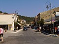 The main street
 -
 View of harbour
 -
 Cruise ships at the harbour
 -
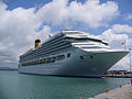 Cruise ship Costa Fortuna in Katakolo, April 2009
 -
 Ioannis Latsis house in Katakolo[8]
 -
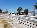 Train station in Katakolo


See also
[edit]Notes
[edit]- ^ "Αποτελέσματα Απογραφής Πληθυσμού - Κατοικιών 2021, Μόνιμος Πληθυσμός κατά οικισμό" [Results of the 2021 Population - Housing Census, Permanent population by settlement] (in Greek). Hellenic Statistical Authority. 29 March 2024.
- ^ Bon 1969, pp. 328–330.
- ^ Bon 1969, pp. 66, 663.
- ^ "Archived copy". Archived from the original on 2020-08-01. Retrieved 2021-03-14.
{{cite web}}: CS1 maint: archived copy as title (link) - ^ "Destruction of Olympia's Ancient Harbour Site by a Tsunami Impact" (PDF). CIESM Congress. 2010. Retrieved 27 December 2018.
- ^ Bon 1969, pp. 663–665.
- ^ TrainOSE, accessed 10 October 2016
- ^ "Katakolon, Greece". KUKUVAYA Ideas. Retrieved 2020-12-23.
References
[edit]- Bon, Antoine (1969). La Morée franque. Recherches historiques, topographiques et archéologiques sur la principauté d'Achaïe (in French). Paris: De Boccard.
External links
[edit]Katakolo
View on GrokipediaGeography and Environment
Location and Topography
Katakolo is a seaside village situated at approximately 37°39′N 21°19′E in the municipality of Pyrgos, within the Elis regional unit of the Peloponnese region, Greece.[5][6] It lies 11 km west of Pyrgos city center, serving as the primary port for the area.[7] The village occupies a headland projecting into the Ionian Sea, where it forms a natural boundary separating the Gulf of Kyparissia to the south from the main expanse of the Ionian Sea.[7] This coastal position features expansive sandy beaches along the shoreline and gentle low hills rising inland, with elevations ranging from sea level to about 80 meters (262 feet).[5][8] The topography also places Katakolo in close proximity to the delta of the Alfeios River, whose mouth opens into the northern part of the Gulf of Kyparissia.[9] The broader surrounding landscape encompasses a flat coastal plain that gradually ascends into the more rugged, mountainous interior of the Peloponnese, with the ancient site of Olympia located roughly 30 km inland to the east.[10]Climate
Katakolo features a hot-summer Mediterranean climate (Köppen classification: Csa), marked by hot, dry summers and mild, rainy winters.[11] This classification reflects the region's typical western Greek coastal patterns, where sea breezes from the Ionian Sea moderate daytime highs.[12] Summer temperatures, from June to August, frequently reach highs of 30–35°C (86–95°F), with August averaging 32°C (90°F), while winter lows in January dip to around 5°C (41°F).[13] The annual mean temperature hovers at approximately 17°C (63°F), supporting a comfortable year-round environment despite seasonal extremes that rarely exceed 38°C (100°F) or fall below 0°C (32°F).[12] Annual precipitation totals about 800 mm, concentrated primarily in the winter months from October to March, when monthly rainfall can exceed 100 mm, such as November's average of 140 mm. Summers remain arid, with July and August receiving less than 10 mm, fostering conditions ideal for coastal activities but highlighting the region's seasonal water variability.[11] The area experiences occasional strong northerly winds, particularly during summer, which can influence local weather and maritime conditions.[14] Katakolo's coastal position renders it vulnerable to erosion, as evidenced by cliff changes detected through monitoring studies showing annual sediment shifts due to storms and wave action.[15] Broader climate change effects, including projected sea-level rise of 20–30 cm by 2050, exacerbate this risk across Greek coastlines, potentially accelerating shoreline retreat in low-lying areas like Katakolo.[16]History
Ancient and Medieval Periods
The area encompassing modern Katakolo was associated with ancient Pheia, a key port town in the region of Pisatis within Elis, dating back to at least the Archaic period.[17] Pheia served as an essential harbor for the city-state of Elis, facilitating trade and the transport of visitors, athletes, and officials to the nearby sanctuary of Olympia, where the ancient Olympic Games were first held in 776 BCE and continued every four years thereafter.[18][19] While archaeological evidence indicates continuous habitation from the Neolithic era through classical antiquity, including harbor installations, fortifications, and residential structures, there are no major ancient Greek ruins directly within the boundaries of present-day Katakolo itself; instead, the site's significance lies in its regional role in the broader Peloponnesian and Eleian historical context, particularly during the Peloponnesian War when it was raided by an Athenian fleet in 431 BCE.[18][17] Pheia was largely destroyed and partially submerged by a tsunami, probably in the 6th century CE following an earthquake, ending its prominence as a port until medieval reutilization.[20][21] During the Byzantine era, the strategic hilltop location overlooking the Bay of Agios Andreas prompted the construction of Pontikokastro fortress, utilizing materials from the ancient acropolis of Pheia for its walls.[17] First documented in 1111 CE, the castle—named Pontikokastro, possibly deriving from "pontos" meaning sea or evoking a mouse-like hill shape—functioned primarily as a defensive structure against invasions, guarding the coastal approaches to Elis.[17][22] It also hosted notable events, such as the marriage agreement between Geoffrey II of Villehardouin and Agnes of Courtenay, as recorded in the Chronicle of the Morea.[17] In the early 13th century, following the Fourth Crusade's sack of Constantinople in 1204, Pontikokastro was captured by Frankish Crusaders around 1205 and integrated into the Principality of Achaea as a vital coastal stronghold.[23][17] The Franks, under the Villehardouin dynasty, repaired and reinforced the fortress, renaming it Beauvoir (beautiful view) in French or Belvedere in Italian, enhancing its role in controlling maritime routes and defending against Byzantine reconquests.[23][22] One of the twelve principal fortresses of the principality, it exemplified Frankish military architecture adapted to Byzantine foundations.[23] The surviving ruins of Pontikokastro, though in poor condition and partially obscured by vegetation, include sections of defensive walls incorporating ancient polygonal masonry and a prominent square tower measuring approximately 8.4 by 8.5 meters at the northwest corner, likely of Byzantine origin.[23][17] These remnants highlight the site's layered history, from ancient port fortifications to medieval defensive works, underscoring Katakolo's enduring strategic value in the Elis region.[17]Modern Developments
Katakolo remained under Ottoman control from the mid-15th century until the Greek War of Independence began in 1821, during which the Peloponnese region, including areas near Katakolo, saw significant revolutionary activity leading to the expulsion of Ottoman forces.[24] Following the war's conclusion with the Treaty of Constantinople in 1832, Katakolo was integrated into the newly established Kingdom of Greece in the early 1830s, though the village experienced limited development as a small coastal settlement until the late 19th century.[25] In the late 19th century, Katakolo began to grow as a fishing village and port, bolstered by the construction of its lighthouse in 1865, which facilitated safer navigation and supported expanding maritime activities, including the export of local raisins.[26] The village's population rose from 301 in 1879 to 612 in 1889, reflecting this economic upturn tied to regional agriculture and trade.[3] During World War II, Katakolo, like much of Greece, endured Axis occupation from 1941 to 1944, which disrupted local fishing and trade; post-war recovery in the mid-20th century saw gradual infrastructure improvements and a return to its role as a modest port community.[27] In the 2000s, the port underwent modernization efforts to accommodate growing cruise tourism, including upgrades to docking facilities that positioned Katakolo as a key gateway to ancient Olympia, attracting increasing ship calls by the mid-decade.[28] The region experienced minor effects from the 6.5-magnitude earthquake that struck northwestern Peloponnese on June 8, 2008, near Patras, with no major damage reported in Katakolo but contributing to broader seismic awareness in the area.[29] The post-2010 Greek financial crisis brought regional economic shifts, including reduced public investment and tourism fluctuations, though Katakolo avoided major local controversies.[30] Into the 21st century, EU-funded infrastructure projects have supported port enhancements and connectivity improvements in Katakolo, aiding its role in tourism recovery.[28] The village's population has stabilized around 500-600 residents amid Greece's broader rural depopulation trends, sustained partly by seasonal tourism and proximity to cultural sites.[2]Economy and Tourism
Local Economy
Katakolo's local economy is anchored in traditional primary sectors, particularly small-scale fishing and limited agriculture, which sustain the community's daily livelihoods. Fishing remains a core industry, with operations primarily targeting species from the Ionian Sea such as sardines and anchovies through family-based vessels operating from the village's harbor. These activities, typical of coastal communities in the Western Greece region, employ a significant portion of residents and contribute to local food security, though production scales are modest compared to larger regional hubs.[31][32] Agriculture complements this, focusing on olives and citrus fruits cultivated on the surrounding plains of Ilia, where such farming accounted for about 27.3% of local employment as of 2011 and supports basic processing for domestic use.[33][34] Trade and commerce in Katakolo involve minor port activities handling local goods like agricultural produce and fish, fostering small-scale exchanges within the Ilia prefecture. The village's historical ties to shipping are exemplified by the legacy of Yiannis Latsis, a prominent Greek shipping magnate born in Katakolo in 1910, whose early family business in the area laid foundational roots for broader maritime commerce, though his empire later expanded globally. These elements provide essential economic circulation but remain limited in scope, serving primarily intra-regional needs rather than large exports.[35][36] Economic challenges have intensified dependence on seasonal work in fishing and agriculture, exacerbated by the Greek economic crisis of the 2010s, which led to increased outmigration, particularly among youth, and heightened unemployment in Western Greece reaching 24.6% by 2018. The crisis contributed to a GDP contraction in Western Greece of 3.9% over the decade from 2008 to 2016, underscoring Katakolo's vulnerability as a small settlement with minimal overall contribution to the regional economy. Support industries, including small retail outlets, basic manufacturing for local goods, and resident-oriented services like tavernas, help buffer these pressures by maintaining community-level commerce.[34] Tourism spillover provides marginal growth to these services, enhancing stability without dominating the non-tourist base.[34]Tourism Industry
Katakolo has emerged as a key gateway for cruise tourism, serving primarily as the port of entry for visitors heading to the nearby Ancient Olympia archaeological site. The port's strategic location on the western Peloponnese coast attracts large cruise vessels, with annual passenger arrivals exceeding 400,000 in recent years, largely driven by scheduled port calls.[37] This influx positions Katakolo as one of Greece's top cruise destinations, transforming its historical role as a modest trading port into a modern tourism hub.[38] The tourism sector in Katakolo has shown robust growth, particularly in cruise traffic, with a record 265 ship arrivals scheduled for 2025, marking an increase from 217 in 2024 and continuing an upward trend post-pandemic.[39] Passenger numbers reached approximately 400,000 in 2024, up from 390,000 in 2023, reflecting strong recovery and expansion in the sector.[37][38] Cruise passengers typically spend an average of approximately €107 per port visit on local services as of 2024, generating substantial revenue estimated in the tens of millions of euros annually for the area through expenditures on excursions, dining, and souvenirs.[40] Economically, tourism dominates Katakolo's modern landscape, employing a significant share of the local workforce in hospitality, tour operations, and ancillary services, while stimulating broader economic activity in retail and transportation.[38] This aligns with Greece's national tourism boom, where the sector contributed 13% to GDP in 2024, underscoring its role in regional development.[41] The year 2024 marked historic highs in arrivals and receipts nationwide, with full recovery from global travel disruptions continuing into 2025.[42] Despite these gains, the industry faces challenges from its seasonal nature, concentrated between April and October, which strains local infrastructure during peaks.[43] Sustainability efforts are underway, including eco-tourism initiatives that promote ethical practices, local sourcing, and community involvement to mitigate overtourism concerns and preserve the region's natural and cultural assets.[44]Visitor Attractions
Cultural and Historical Sites
Katakolo boasts several cultural and historical sites that highlight its layered past, from medieval fortifications to modern maritime landmarks, offering visitors insights into the region's heritage through accessible ruins, museums, and architecture. These attractions emphasize the village's role as a historical port and its connections to broader Greek history, with many sites featuring interpretive elements for enhanced visitor experience. The Pontikokastro ruins, a medieval Frankish castle constructed in the 13th century on the acropolis of ancient Pheia and an older Byzantine fortress site, also known historically as Beauvoir (French) or Belvedere (Italian), stand as prominent remnants overlooking the port of Katakolo.[23] The site includes preserved walls and towers that provide panoramic views of the Ionian Sea and surrounding bay, with accessible trails leading to the fortress for exploration.[45] Interpretive signage along the paths details its history of reconstruction and destruction during conflicts, making it a key spot for understanding medieval defensive architecture in the Peloponnese.[46] Nearby, the Museum of Ancient Greek Technology, a branch of Kostas Kotsanas' collection located just 150 meters from the port, showcases around 300 functional models of innovations from 2000 BC to 100 AD, drawing from ancient texts and artifacts.[47] Exhibits include replicas of water mills, gears from the Antikythera mechanism, Plato's alarm clock, and Heron's automated devices, presented with interactive displays, audio-visual aids in Greek and English, and diagrams to illustrate their engineering principles.[47] This small yet engaging museum highlights Olympia's technological legacy, serving as an educational hub for visitors interested in ancient ingenuity.[48] The Katakolo Lighthouse, built in 1865 as a French-designed structure, features a 9-meter stone tower with a focal height of 45 meters, originally powered by oil lamps and now automated.[49] Positioned on the southwest entrance to the port, it offers striking sea views and photo opportunities from its elevated location, with the site declared a protected historical monument by Greece's Ministry of Culture.[49] Its rotating mechanism, once operated by a pendulum clock-like system producing four flashes every 16 seconds, underscores 19th-century maritime advancements.[26] Other notable sites include the Agios Nikolaos Church, a picturesque white-and-blue structure in the central square dating to the early 20th century, dedicated to the patron saint of sailors and featuring ornate marble interiors.[50] The surrounding traditional architecture, characterized by pastel-colored neoclassical buildings from the 19th century lining the harborfront, reflects the village's evolution as a trading port with elements of Cycladic island influences.[51] Katakolo's proximity to Ancient Olympia positions it as a convenient base for excursions to that UNESCO-listed site.[7]Natural and Recreational Features
Katakolo's coastline features a sandy beach approximately 0.5 km long, with the broader area along the Kyparissian Gulf stretching about 30 kilometers, offering clear, shallow waters ideal for swimming and sunbathing.[52] Nearby beaches such as Kourouta and Arkoudi have earned Blue Flag status for their environmental cleanliness and safety standards during peak tourist seasons, ensuring high-quality facilities and water purity.[53][54] Recreational opportunities abound along the headland, where walking paths offer scenic views of the Ionian Sea and surrounding landscapes, suitable for leisurely strolls or light hiking.[51] Water sports enthusiasts can engage in snorkeling, kayaking, paddleboarding, and windsurfing, with rentals available directly from the beachfront.[55] The nearby Alfeios River delta provides a tranquil wetland area for birdwatching, hosting migratory species such as herons and egrets amid salt marshes and reed beds.[56] The region's coastal ecosystem includes protective dunes that stabilize the shoreline and lush olive groves that contribute to biodiversity, with parts of the area designated under the European Union's Natura 2000 network to preserve marine habitats and species like sea turtles.[57] Visitors can participate in fishing tours or rent boats for coastal exploration, while seasonal beach volleyball games and organized water activities enhance the leisure experience during summer months.[58][59] The mild Mediterranean climate supports year-round outdoor access, though peak activities align with warmer seasons.[8]Transport
Road and Rail Connections
Katakolo is connected to the regional road network primarily through Greek National Road 9 (EO-9), also designated as European route E65, which runs along the western Peloponnese coast. This highway links Katakolo directly to the nearby city of Pyrgos, approximately 12 km to the east, providing a quick 14-minute drive for local access.[60] Further north, the road extends about 94 km to Patras, facilitating broader regional connectivity with a typical travel time of around 1 hour by car.[61] Local secondary roads branch off from EO-9, offering easy access to nearby beaches and archaeological sites along the Ionian coast. Bus services operated by KTEL Ilia connect Katakolo to Pyrgos with frequent departures, running every four hours daily and taking about 20 minutes, with tickets costing €1–2.[62][60] The rail infrastructure in Katakolo includes a regional line integrated into the Hellenic Train network, linking the port to Pyrgos in roughly 20–22 minutes via the line 1382 train, with two daily departures and fares of €1–2.[60] This historic branch, originally opened in 1882 as the Pyrgos–Katakolo Railway to serve the port, was extended approximately 33 km eastward to Ancient Olympia, with the Olympia station inaugurating operations in 1891 to support exports like raisins and enhance pilgrimage access.[62] Today, seasonal tourist trains operate on this route from Katakolo to Olympia, running Monday through Saturday with a journey time of about 45 minutes and round-trip tickets priced at €10, passing through scenic Peloponnesian landscapes.[63] Accessibility enhancements include free public parking lots available near the port area, accommodating vehicles for short-term visits without charge.[64] Along the coastline, informal bike paths and cycling routes allow for leisurely exploration, with e-bike rentals supporting eco-friendly travel over the flat terrain. These road and rail options integrate seamlessly with regional transport hubs in Pyrgos and Patras, enabling efficient day trips to key sites like Ancient Olympia and thereby supporting tourism arrivals in the area.[65][62]Port Facilities
The port of Katakolo features a modern cruise terminal that underwent significant upgrades in the early 2010s, including infrastructure enhancements funded through EU state aid to increase capacity for larger vessels.[28] The terminal includes three piers designed to serve cruise ships, with two accommodating vessels up to 300 meters in length and one up to 200 meters, alongside an average water depth ranging from 7.5 to 10.5 meters, enabling berthing for large cruise ships.[66] This setup allows the port to handle substantial passenger volumes, supporting ships with capacities reaching several thousand passengers, such as those common in Mediterranean itineraries.[67] Operations at Katakolo primarily focus on passenger services, with the majority of activity centered on cruise ship calls and limited ferry routes for regional travel, while cargo handling is restricted to small-scale local goods like agricultural products.[68] The port is managed by the Pyrgos Municipal Port Fund, a public entity under Greek local authority, which oversees daily functions including security under the International Ship and Port Facility Security (ISPS) Code and has benefited from EU funding for maintenance and development.[66] Berthing is available on both sides of the piers, with pilotage compulsory and VHF Channel 12 used for communications, ensuring efficient turnaround for passenger vessels.[69] Key facilities include a two-story terminal building equipped with security checkpoints, administrative offices, passenger lounges, and excursion booking desks for organized tours to nearby sites like ancient Olympia.[70] Additional amenities comprise duty-free shops, currency exchange services, free Wi-Fi, and adjacent cafes, all located within a short walk from the berths to the town center.[71] An adjacent smaller harbor supports local fishing operations, accommodating small boats for commercial and recreational use, contributing to the port's mixed maritime role.[72] In terms of capacity, Katakolo is scheduled to host 265 cruise ship calls in 2025, marking a record for the facility and underscoring its growing prominence in the Greek cruise sector.[39] Future expansion plans involve an international tender launched by the Hellenic Republic Asset Development Fund to upgrade infrastructure, aiming to further boost cruise traffic and integrate with broader Mediterranean routes through enhanced sub-concessions.[38] The port's location facilitates brief connections to nearby road and rail networks for seamless onward passenger travel.[73]Demographics and Society
Population Trends
Katakolo maintains a small resident population, recorded at 502 in the 2021 census, reflecting a stable but modestly declining community typical of rural coastal settlements in Greece.[2] This figure represents a slight decrease from previous decades, indicative of broader demographic shifts in the region. The settlement's population is predominantly of Greek ethnicity, with low levels of immigration contributing to a homogeneous composition; census data shows over 95% Greek nationals in similar small communities within the Elis regional unit.[74] Average household sizes stand at approximately 2.5 persons, aligning with national trends of shrinking family units due to low birth rates and aging.[75] Historical census data illustrates a pattern of gradual decline over the past three decades, driven primarily by urbanization and economic migration toward larger centers like Pyrgos and Athens. The table below summarizes key census figures for permanent residents:| Year | Population |
|---|---|
| 1991 | 570 |
| 2001 | 600 |
| 2011 | 509 |
| 2021 | 502 |