



Community hub


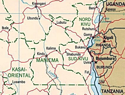
Kivu is the name for a large region in the eastern Democratic Republic of the Congo that borders Lake Kivu. It was a Région (read 'province') of the country under the rule of Mobutu Sese Seko from 1966 to 1988. As an official Région in 1986 it was divided into the three "Sub-Regions" (Sous-Régions in French) of: Nord-Kivu, Sud-Kivu and Maniema,[1][2] Those three became the current provinces in the reorganization of 1988.[3] The capital of the Kivu Region was in Bukavu, and the capitals of the three Sub-Regions were in Goma, Uvira and Kindu.
History
[edit]Kivu has been repeatedly subjected to major conflicts since the early 20th century. Under Belgian colonial rule, it was the site of several religious revolts such as the 1944 Kivu uprising.[4] Following independence, it was a battleground of the Simba rebellion, First Congo War, and Second Congo War, and has been the site of an ongoing military conflict since the early 2000s. In 2025 substantial parts of the area came under the control of the March 23 Movement.
From August 2018 to June 2020, an Ebola epidemic affected the region.
Geography
[edit]Kivu is also the name for the entire region surrounding Lake Kivu, including the portions in Rwanda which contain the vast majority of the lake area's population (the contiguous towns of Goma in the Democratic Republic of Congo and Gisenyi in Rwanda, with a combined population approaching 1,000,000, form the largest urbanised area in the Lake Kivu area).[5] The area is characterized by lush vegetation and an extended growing season due in part to its high elevation (1500 m or 4900 ft at the lakeshore) and the volcanic nature of its soil. The Kivu region represents the high point of the East African Rift Valley.
The lake itself contains a massive amount of carbon dioxide in its depths, and there is some concern that tectonic activity (rifting) and/or volcanic activity might cause a limnic eruption, a sudden release of this captured carbon dioxide. If this were to happen it would devastate the population around the lake; however, the likelihood of this occurring is in dispute.
Approximate correspondence between historical and current provinces
[edit]| Belgian Congo | Republic of the Congo | Zaire | Democratic Republic of the Congo | ||||||
|---|---|---|---|---|---|---|---|---|---|
| 1908 | 1919 | 1932 | 1947 | 1963 | 1966 | 1971 | 1988 | 1997 | 2015 |
| 22 districts | 4 provinces | 6 provinces | 6 provinces | 21 provinces + capital | 8 provinces + capital | 8 provinces + capital | 11 provinces | 11 provinces | 26 provinces |
| Bas-Uele | Orientale | Stanleyville | Orientale | Uele | Orientale | Haut-Zaïre | Orientale | Bas-Uele | |
| Haut-Uele | Haut-Uele | ||||||||
| Ituri | Kibali-Ituri | Ituri | |||||||
| Stanleyville | Haut-Congo | Tshopo | |||||||
| Aruwimi | |||||||||
| Maniema | Costermansville | Kivu | Maniema | Kivu | Maniema | ||||
| Lowa | |||||||||
| Kivu | Nord-Kivu | Nord-Kivu | |||||||
| Kivu-Central | Sud-Kivu | ||||||||
References
[edit]- ^ International Crisis Group (9 July 2009). Congo: A Comprehensive Strategy to Disarm the FDLR (PDF). Africa Report No. 151. p. 1, note 1.
- ^ "Democratic Republic of Congo: Mobility and Methods of Transportation between Grand Kivu and Kinshasa" (PDF). Justice.gov. Immigration and Refugee Board of Canada. 18 April 2012. p. 1. Retrieved 8 October 2025.
- ^ Bruneau, Jean-Claude (30 June 2009). "Les nouvelles provinces de la République Démocratique du Congo : construction territoriale et ethnicités". L'Espace Politique (in French). 7 (2009–1). doi:10.4000/espacepolitique.1296. Retrieved 7 March 2025.
- ^ Stearns, Jason (2012). "North Kivu: The background to conflict in north Kivu province in eastern Congo" (PDF). refworld.org. pp. 14–15.
- ^ "Lake Kivu Home Page". Archived from the original on 2008-05-28. Retrieved 2008-06-16.
2°30′S 28°00′E / 2.500°S 28.000°E
| International | |
|---|---|
| National | |
| Other | |

History
Pre-Colonial Era
The Kivu region, located in the eastern highlands of the Congo Basin around Lake Kivu, featured human occupation traceable to the Paleolithic era through archaeological evidence of tools and settlements in associated areas like the Virunga region. Bantu migrations, beginning around 2000 BCE and continuing into the early centuries CE, introduced ironworking, agriculture, and more complex social structures, displacing or assimilating earlier hunter-gatherer populations such as Pygmies. By the Iron Age (ca. 400 BCE–650 CE in the broader Congo Basin), subsistence economies emphasized plant cultivation, including cereals and later crops suited to highland environments.[14][15] Pre-colonial societies in Kivu were organized into a heterogeneous array of chiefdoms and small kingdoms, often with decentralized authority where rulers exerted loose control through kinship networks, ritual leadership, and patrimonial obligations rather than centralized bureaucracies. In South Kivu, the Shi people established the Kingdom of Bushi, a hierarchical polity spanning highlands from Kabare to Walungu, governed by a mwami (king) who oversaw tribute, dispute resolution, and alliances via marriage and trade. The Lega, migrating southward from present-day Uganda in the 16th century, formed segmentary lineages in southwestern Kivu (including parts of modern Maniema), emphasizing initiation societies (bwami) for social cohesion and warfare prowess over formal kingship. North Kivu hosted groups like the Hunde and Nande in chiefdoms such as Bamate and Bashu, focused on clan-based land tenure and inter-group raids.[16][17][18][19] Economic life centered on slash-and-burn farming of staples like sorghum, yams, and bananas, supplemented by hunting, fishing in Lake Kivu, and foraging; livestock such as goats and cattle were limited by tsetse fly prevalence but valued for status. Regional trade networks linked Kivu polities to interlacustrine neighbors (e.g., Rwanda, Burundi), exchanging iron tools, salt, ivory, and slaves for cloth, cattle, and ceramics, fostering cultural exchanges but also conflicts over resources. Social structures prioritized lineage solidarity and age-grade systems, with chiefs deriving legitimacy from spiritual mediation and customary law rather than coercive taxation, though warfare between chiefdoms was common for captives and territory.[20][21]Colonial Administration
The Kivu region, encompassing the eastern highlands around Lake Kivu, fell under the nominal sovereignty of the Congo Free State upon its international recognition at the Berlin Conference on 26 February 1885, though direct Belgian control was sparse and primarily extractive in remote areas until the early 20th century. German explorer Gustav Adolf von Götzen circumnavigated Lake Kivu in October 1894, prompting territorial assertions by agents of King Leopold II, who established military posts and trading stations amid resistance from local kingdoms such as those of the Shi and Lega peoples. Administration during this period relied on the Force Publique for enforcement, with quotas for ivory, rubber, and labor extraction driving coercive policies that depopulated parts of the region through violence and disease, though systematic documentation specific to Kivu remains limited compared to the rubber heartlands in the northwest.[22] Following international scrutiny and Belgium's annexation of the territory as the Belgian Congo on 18 October 1908, the colonial administration restructured eastern Congo to consolidate governance, creating the Ruzizi-Kivu District in 1902 as a military-administered zone spanning from Beni to Kalembelembe, focused on border security against German East Africa. A royal decree (arrêté royal) of 28 March 1912 further divided the Belgian Congo into 22 districts, formalizing Kivu District to oversee territories around Lake Kivu, including present-day North and South Kivu areas, under a district commissioner reporting to the Governor-General in Boma (later Léopoldville). This structure emphasized indirect rule through appointed chiefs (chefs de terre), who collected taxes and mobilized labor for infrastructure like the Kivu-Goma road completed in the 1920s, while European concession companies dominated mining (cassiterite) and agriculture.[23][24] Administrative reforms in the 1930s elevated the region's status amid economic expansion; on 1 October 1933, Kivu and adjacent Maniema districts were merged to form Costermansville Province (named after explorer Fernand Costermans), with Bukavu (formerly Costermansville, founded 1901) as capital, to streamline oversight of growing coffee plantations yielding over 10,000 tons annually by 1940 and tin production exceeding 2,000 metric tons yearly from Maniema mines. The province was renamed Kivu in 1947, reflecting geographic focus, and subdivided into territories led by administrators enforcing compulsory cultivation (travail forcé) for export crops under the 1920s Native Labour Code, which mandated 120-180 days of annual labor per adult male, though enforcement varied and drew criticism for inefficiencies rather than the Free State's outright brutality. Provincial governors, appointed from Brussels, coordinated with the central Ministry of Colonies, prioritizing European settler farms on fertile volcanic soils while restricting indigenous land ownership, a policy that entrenched ethnic hierarchies by favoring Tutsi and Hutu migrants for labor transplantation programs initiated in the 1930s.[24][25][26] Post-World War II adjustments included limited political concessions, such as advisory councils with African representatives from 1948, but real power remained with Belgian officials until independence; Kivu's administration facilitated over 50,000 Rwandan immigrants' settlement by 1959 for agricultural labor, altering demographics and sowing seeds for post-colonial tensions without fostering local autonomy. Economic data from colonial reports indicate the province contributed 15% of Congo's coffee exports by 1955, underscoring its role in Belgium's paternalistic development model, which invested in missions and health posts but suppressed unions and education beyond primary levels for most Africans.[27][28]Post-Independence Reorganization
Upon achieving independence from Belgium on June 30, 1960, the Republic of the Congo retained Kivu as one of its six initial provinces, encompassing a vast eastern territory including present-day North Kivu, South Kivu, and Maniema.[24] This structure inherited colonial boundaries established in 1933, with Kivu (formerly Costermansville Province) administering diverse ethnic groups amid the chaotic Congo Crisis, which saw regional secessions and rebellions.[24] Early post-independence instability led to temporary fragmentation; by February 1961, rebel influences formed the short-lived Kivu-Maniema entity, which central authorities dismantled by January 1962.[24] On May 10, 1962, the central government reorganized Kivu by detaching Maniema as a separate province and establishing Nord-Kivu (North Kivu) on August 14, 1962, from northern districts, reflecting efforts to quell unrest and assert control during the crisis.[24] [19] The remaining southern and central areas of original Kivu were reconstituted as Kivu Central Province on May 18, 1963, further subdividing administration to address local governance challenges.[24] These changes occurred against a backdrop of national fragmentation, with over 20 provinces briefly existing by 1963 due to provincial autonomy laws.[29] Following Joseph Mobutu's consolidation of power via military coup in November 1965, administrative centralization intensified. A presidential decree on April 6, 1966, reduced provinces nationwide to 12, followed by further consolidation; on April 25, 1966, Kivu Central merged with Maniema to form Sud-Kivu (South Kivu), but by December 28, 1966, the unified Kivu Province was restored, absorbing Nord-Kivu and Sud-Kivu to streamline control under eight provinces total.[24] [29] This reunification aligned with Mobutu's strategy to weaken regional power bases, though it masked underlying ethnic tensions in Kivu's multi-ethnic landscape.[29] Kivu persisted as a single province through much of Mobutu's Zaire era (1971–1997), but administrative pressures prompted its division on July 20, 1988, into three provinces: Nord-Kivu, Sud-Kivu, and Maniema, ostensibly for better management but reportedly exacerbating communal strains among indigenous and immigrant groups like Banyarwanda.[24] [28] This split, formalized by decree, reflected Mobutu's tactic of fostering ethnic rivalries to maintain national dominance, contributing to localized conflicts that intensified in the 1990s.[29] [28] The 1988 boundaries largely endure today, despite subsequent national reforms under the 2006 constitution expanding provinces to 26 without altering Kivu's core divisions.[30]Late 20th-Century Changes
During the Mobutu Sese Seko era, the Kivu region underwent significant administrative reconfiguration as part of broader efforts to centralize power and mitigate ethnic-based opposition. In 1988, the unified Kivu province was subdivided into three entities—North Kivu, South Kivu, and Maniema—to fragment regional power structures and foster rivalries among local elites, aligning with Mobutu's strategy of divide-and-rule governance.[29] This reorganization intensified competitions over land and resources in the fertile highlands, particularly in North Kivu's Masisi and Rutshuru territories, where colonial-era migrations of Rwandan-origin populations had already strained relations with indigenous groups.[28] Economic policies implemented nationally, such as the 1973-1974 Zairianization campaign, which expropriated foreign-owned enterprises and redistributed them to Zairian citizens, disrupted agricultural productivity and mining operations in Kivu, contributing to regional decline amid widespread corruption and mismanagement under Mobutu's kleptocratic rule.[31] The policy favored Mobutu's allies, often exacerbating ethnic inequalities, as Tutsi and other minority entrepreneurs in Kivu faced discrimination and loss of assets, fueling grievances that persisted into the 1990s.[32] The most transformative event occurred in mid-1994, when the Rwandan genocide prompted an exodus of over 1 million Hutu refugees, including elements of the defeated Rwandan government army and Interahamwe militias, into North Kivu's border areas around Goma.[33] These refugees overwhelmed local infrastructure, with camps housing 500,000 to 850,000 people in July 1994 alone, leading to humanitarian crises including cholera outbreaks that killed tens of thousands.[34] Mobutu's regime, weakened and complicit in some attacks, failed to disarm the ex-militants, who used camps as bases for raids into Rwanda and assaults on Congolese Tutsi communities, resulting in thousands of deaths and mass displacements of Banyamulenge and other groups.[33] This volatility eroded state authority, inciting local self-defense militias and setting the stage for the 1996 rebellion led by Laurent-Désiré Kabila's Alliance of Democratic Forces for the Liberation of Congo, which mobilized in Kivu and ultimately toppled Mobutu in 1997.[31]Geography
Physical Features
The Kivu region, encompassing North and South Kivu provinces in the eastern Democratic Republic of the Congo, features a topography dominated by the western branch of the East African Rift system, where tectonic extension has produced fault-bounded basins, volcanic highlands, and rift lakes.[35] This rifting, ongoing since the Cenozoic era, has facilitated magma ascent, leading to widespread volcanism and the formation of elevated massifs amid surrounding plateaus and lowlands.[35] Lake Kivu occupies a central rift depression shared with Rwanda, spanning 2,370 square kilometers with a shoreline of 860 kilometers, a north-south length of 97 kilometers, an average depth of 240 meters, and a maximum depth of 485 meters at an elevation of approximately 1,460 meters above sea level.[36] The lake is meromictic, with deep anoxic layers accumulating dissolved methane and carbon dioxide from volcanic degassing and bacterial decomposition, posing risks of limnic eruptions if stratification disrupts.[37] Its basin formed through combined tectonic subsidence and volcanic damming, integrating with the regional hydrology via inflows from the Ruzizi River and outflows toward Lake Tanganyika.[38] Northward from the lake, the Virunga Mountains rise as a volcanic chain extending about 80 kilometers along the rift, comprising eight stratovolcanoes born from rift-related magmatism, with summits exceeding 3,000 meters amid equatorial montane forests and lava fields.[39] Mount Nyiragongo, reaching 3,470 meters, stands as a highly active stratovolcano 12 kilometers north of Goma, hosting a semi-permanent lava lake in its summit crater since at least 2002 and prone to flank eruptions, as in January 2002 and May 2021, which produced fast-moving lava flows threatening lakeside populations.[40][41] Adjacent Nyamuragira, at 3,058 meters, frequently erupts with effusive basaltic flows covering extensive areas of the rift floor.[42] South Kivu's landscape integrates high plateaus, deeply incised valleys, cascading waterfalls, and broad fertile plains derived from weathered volcanic materials, interspersed with dense rainforests and montane ecosystems up to 2,500 meters elevation.[43] Across both provinces, rift fault scarps define steep escarpments dropping toward the central Congo Basin, while seismic activity underscores the dynamic crustal thinning driving these features.[44]Climate and Environment
The Kivu region, encompassing North Kivu and South Kivu provinces in the eastern Democratic Republic of the Congo, features an equatorial highland climate with bimodal rainfall patterns typical of Zone 3 in northeastern DRC. Two rainy seasons occur from March to May and September to November, interspersed with drier periods from December to February and June to August, supporting agriculture but also contributing to seasonal flooding and landslides in hilly terrain. Annual precipitation varies by elevation, generally ranging from 1,200 to 2,000 mm, with higher amounts in montane areas like the Virunga Mountains.[45] Temperatures are relatively stable due to altitude, with average highs of 25°C and lows around 15°C in South Kivu, though cooler conditions prevail at elevations above 2,000 meters.[46] Geologically, the region lies within the Western Branch of the East African Rift System, characterized by active volcanism that influences local climate and soil fertility. Mount Nyiragongo, located near Goma in North Kivu, hosts a persistent summit lava lake and erupted destructively on May 22, 2021, producing lava flows that reached the city outskirts, displacing over 400,000 people and destroying infrastructure across approximately 13 km². Nearby Nyamuragira volcano has shown elevated thermal activity and seismic unrest through 2023, with its 2018 eruption covering 32 km² in ash. Volcanic soils enhance agricultural productivity but also heighten risks of seismic-induced gas releases from Lake Kivu, which contains approximately 300 million cubic meters of dissolved methane and 60 billion cubic meters of CO₂ at depths below 250 meters, posing potential limnic eruption hazards akin to those at Lakes Monoun and Nyos.[40][47][42][48] Biodiversity in the Kivu area is concentrated in aquatic and terrestrial habitats, though constrained by the lake's meromictic stratification limiting oxygen below 100 meters. Lake Kivu supports about 29 fish species, primarily from families Cichlidae, Clariidae, Cyprinidae, and Clupeidae, with roughly half being endemic cichlids adapted to its unique chemistry; surrounding wetlands and forests host diverse avifauna, invertebrates, and mammals, including critically endangered eastern mountain gorillas in adjacent Virunga and Kahuzi-Biega National Parks. However, ongoing armed conflicts, such as the M23 insurgency since late 2021, have accelerated habitat degradation, with tree cover loss in these parks surging by factors of 2–5 times pre-conflict rates due to illegal logging, displacement-driven farming, and resource extraction by militias.[49][50] Key environmental pressures include deforestation and soil erosion from slash-and-burn agriculture, exacerbated by population pressures and conflict, leading to annual losses of over 100,000 hectares of forest in the broader Kivu provinces. Lake Kivu faces pollution from untreated effluents, plastic waste clogging inflows like the Ruzizi River, and invasive species introductions, undermining fisheries that yield around 20,000 tons annually. Weak governance and enforcement amid insecurity further compound these issues, with studies attributing much degradation to human activities rather than solely climatic factors.[51][52][53][54]Natural Resources Overview
The Kivu provinces in the Democratic Republic of the Congo possess substantial mineral deposits, including coltan (a source of tantalum), cassiterite (tin ore), wolframite (tungsten ore), and gold, which are predominantly mined through artisanal and small-scale operations.[55] [6] These resources, often categorized as the "3T+G" minerals (tin, tantalum, tungsten, and gold), account for a significant portion of eastern DRC's export value, with coltan production in the region supporting global electronics supply chains.[56] However, extraction is hampered by insecurity, with armed groups controlling many sites and complicating traceability efforts under international certification schemes.[12] Lake Kivu, straddling the border with Rwanda, contains dissolved methane gas reserves estimated at 55 to 60 billion cubic meters, alongside carbon dioxide, presenting opportunities for clean energy generation.[57] [58] Pilot extraction facilities, primarily on the Rwandan side, pump gas-saturated deep waters to the surface for separation and power production, yielding up to 100 megawatts as of 2024, though Congolese-side development lags due to regulatory and technical hurdles.[59] [60] The lake's volcanic origins also contribute geothermal potential, while its waters support fisheries yielding thousands of tons of tilapia and sardines annually.[61] Extensive tropical forests cover much of Kivu, part of the Congo Basin's 3.7 million square kilometers of intact rainforest, harboring high biodiversity with over 300 bird species and endangered primates in areas like Kahuzi-Biega National Park.[62] [63] These ecosystems yield timber and non-timber products such as medicinal plants, but face degradation from charcoal production and agricultural expansion on fertile volcanic soils, which sustain crops including coffee, bananas, and cassava.[64] [65] Hydroelectric resources from rivers like the Ruzizi further enhance the region's renewable energy prospects, with installed capacities exceeding 700 megawatts at shared dams.[66]Administrative Divisions
Historical Province Structure
The province of Kivu originated in the Belgian Congo on 1 October 1933, when the territories of Kivu and Maniema were organized into the Province of Costermansville.[19] This structure centralized administration over eastern territories including present-day North Kivu, South Kivu, and Maniema, under a provincial governor responsible for districts subdivided into territories and chiefdoms.[19] In 1947, the province was renamed Kivu, reflecting its geographic focus around Lake Kivu and the surrounding highlands, while retaining the hierarchical divisions of districts (e.g., Sud-Kivu and Nord-Kivu districts) under territorial commissioners and indigenous chiefs.[19] Following independence on 1 July 1960, Kivu Province persisted as one of six provinces in the Republic of the Congo (later Democratic Republic of the Congo and Zaire), encompassing approximately 256,700 square kilometers and administered from Bukavu as capital.[19] Decentralization efforts in the early post-independence period led to its subdivision on 14 August 1962 into three provinces: North Kivu (capital Goma), South Kivu (capital Bukavu), and Maniema (capital Kindu), each with governors and assemblies to address ethnic and regional tensions.[25] This tripartite structure aimed to devolve power but faced instability, resulting in reunification on 28 December 1966 under a single Kivu Province governorate.[24] Under Mobutu Sese Seko's Zaire regime, administrative reforms culminated in the 20 July 1988 division of Kivu Province into three permanent provinces: Maniema, Nord-Kivu (North Kivu), and Sud-Kivu (South Kivu), via Law No. 88-002, which redefined boundaries to align with ethnic clusters and resource zones while establishing provincial assemblies and commissioners.[24] North Kivu covered the northern rift areas up to the Uganda border, South Kivu the lake district southward, and Maniema the transitional forests eastward, with capitals at Goma, Bukavu, and Kindu respectively; this framework emphasized centralized oversight from Kinshasa despite local autonomy provisions.[24] The 1988 reconfiguration, motivated by governance efficiency claims amid economic decline, endured through the First Congo War and into the Democratic Republic of the Congo's 1997 renaming, forming the basis for subsequent territorial administrations.[24]Current Provincial Breakdown
The Kivu region, historically a single province, has been administratively divided since 1988 into three provinces under the Democratic Republic of the Congo's structure: North Kivu, South Kivu, and Maniema.[67] This subdivision reflects post-colonial reorganizations aimed at decentralizing governance, though central control remains contested amid ongoing conflicts. North Kivu and South Kivu form the core of the Kivu region bordering Rwanda and Burundi, while Maniema lies to the west, sharing cultural and economic ties but often treated separately in security analyses.[68][69] North Kivu Province, with its capital at Goma, spans approximately 59,483 square kilometers and borders Uganda, Rwanda, and Ituri Province.[70] Its estimated population reached 12,024,400 as of January 2025, driven by high birth rates and displacement from armed groups.[71] The province is subdivided into eight territories, including Beni, Lubero, and Rutshuru, which encompass volcanic highlands, Lake Kivu's northern shores, and Virunga National Park. Governance is headquartered in Goma, a city of over 1 million residents strained by refugee influxes and M23 rebel activities as of 2025.[69][72] South Kivu Province, centered in Bukavu, covers about 64,343 square kilometers and adjoins Rwanda, Burundi, and Maniema.[70] Its population was estimated at 8,147,400 in 2024, concentrated in highland plateaus and the Ruzizi Plain along Lake Kivu's southern extent.[73] Administratively, it includes six territories such as Fizi, Kalehe, and Walungu, with Bukavu serving as the economic hub despite infrastructure deficits and militia presence.[74] Recent conflicts, including M23 advances, have exacerbated internal displacements, with over 700,000 people fleeing toward Goma by early 2025.[75] Maniema Province, with Kindu as capital, extends 134,315 square kilometers westward from the Kivus, bordering Tanganyika and Lualaba provinces. Its population estimates hover around 2.5 million, primarily rural and reliant on the Congo River basin.[76] Though linked historically to Kivu through pre-1960s administrative units, Maniema operates as a distinct entity focused on forestry and modest mining, with less direct involvement in cross-border insurgencies compared to its eastern neighbors.[67]| Province | Capital | Area (km²) | Population (est.) | Key Territories |
|---|---|---|---|---|
| North Kivu | Goma | 59,483 | 12,024,400 (2025) | Beni, Masisi, Rutshuru |
| South Kivu | Bukavu | 64,343 | 8,147,400 (2024) | Fizi, Mwenga, Uvira |
| Maniema | Kindu | 134,315 | ~2.5 million | Kibua, Kabambare |
Border and Territorial Disputes
The boundary between the Democratic Republic of the Congo (DRC) and Rwanda, which forms the eastern edge of the Kivu provinces, spans approximately 135 miles, with about 71 miles traversing Lake Kivu. This demarcation was established through colonial-era agreements, including the 1910 Anglo-German-Belgian conference and the Belgium-Germany convention, which defined the line across the lake starting from the Ruzizi River outlet. Islands in Lake Kivu were allocated accordingly, with larger ones such as Idjwi assigned to the Belgian Congo (now DRC), while smaller islands like Gombo, Kumenie, and Wau went to German East Africa (now Rwanda).[77] No formal territorial disputes exist between the DRC and Rwanda over the Kivu border, as the boundaries are internationally recognized under postcolonial inheritance. However, unofficial Congolese claims have arisen regarding small islands in Lake Kivu, including Ile Gombo, Ile Wa, and Ile Kihaya, though these lack official endorsement and have not escalated to diplomatic contention. Historical precolonial expansions by the Rwandan kingdom under Mwami Rwabugiri into areas now part of North Kivu have fueled narratives in Rwanda of a "greater Rwanda," invoking ethnic Tutsi ties and past entanglements to question colonial border legitimacy, yet these do not translate to contemporary sovereignty demands.[77][78][79] Ongoing armed conflicts in the Kivus, particularly involving the M23 rebel group in North and South Kivu, have intensified border tensions without altering formal territorial claims. Rwanda faces accusations from the DRC and United Nations reports of supporting M23 to secure influence over border areas for security against Democratic Forces for the Liberation of Rwanda (FDLR) militias and access to minerals, claims Rwanda attributes to defensive necessities rather than expansionism. In March 2025, M23 forces captured parts of Idjwi Island, a DRC-administered territory in Lake Kivu, consolidating control over lake access near the Rwandan maritime border, but this represents rebel territorial gains amid instability rather than a state-level dispute. Comments by Rwandan President Paul Kagame in 2023 on the historical border's origins were interpreted by some Congolese as irredentist, though he affirmed no intent to redraw lines, underscoring the fixed nature of postcolonial frontiers under international law.[80][81][82]Demographics
Ethnic Composition
The ethnic composition of North Kivu province is dominated by Bantu-speaking groups, with the Nande forming the largest indigenous population, primarily inhabiting areas around Lake Kivu and the Ruwenzori Mountains, where they engage in agriculture and trade. Other significant autochthonous groups include the Hunde, concentrated in the highlands north of Lake Kivu, and the Nyanga, residing in the mountainous regions to the west. Kinyarwanda-speaking communities, collectively known as Banyarwanda, constitute a notable minority, encompassing both Hutu and Tutsi subgroups descended from historical migrations and later refugee influxes from Rwanda, particularly after 1959 and 1994; these groups are interspersed across the province, often in urban centers like Goma and along the Rwandan border, amid ongoing disputes over indigeneity and citizenship.[83][84] In South Kivu, the Shi represent the predominant ethnic group, mainly settled in the western plateaus and around Bukavu, comprising a substantial portion of the rural population through farming communities. Complementary indigenous groups include the Fuliru (or Bafuliiru) along the northern shores of Lake Kivu, the Bembe in the southern border areas with Burundi, and smaller clusters such as the Vira, Nyindu, and Lega (Balega) in peripheral zones. The Banyamulenge, a Tutsi subgroup tracing origins to 16th-18th century pastoralist migrations from regions now encompassing Rwanda and Burundi, form a distinct minority primarily in the highland Itombwe and Mulenge areas, with historical estimates placing their numbers at around 400,000 by the late 1990s, though exact figures remain uncertain due to conflict-driven displacements and lack of comprehensive censuses since 1984.[83][84][85] Across both provinces, smaller populations of Batwa (Pygmy) hunter-gatherers persist in forested margins, often marginalized and facing land pressures from expanding Bantu groups, while inter-ethnic tensions, exacerbated by armed conflicts since the 1990s, have led to fluid demographics through internal displacements affecting millions; reliable quantitative breakdowns are scarce, as the Democratic Republic of Congo has not conducted a national census incorporating ethnicity since the colonial era, relying instead on estimates from humanitarian organizations that highlight the provinces' multi-ethnic volatility without precise proportions.[83][69]Population Dynamics
The population of South Kivu province was estimated at 8,147,400 in 2024, reflecting substantial growth from prior decades despite persistent conflict.[73] North Kivu, the more populous of the two, hosts an estimated 10-12 million residents based on displacement-adjusted projections, contributing to one of Africa's highest regional densities outside urban centers.[86] National fertility rates of around 6 children per woman drive baseline annual growth of approximately 3.2% across the Democratic Republic of the Congo, with similar patterns in Kivu where rural agrarian societies sustain high birth rates amid limited access to family planning.[87] However, verifiable provincial growth metrics remain imprecise due to underreporting in conflict zones and reliance on extrapolations from the 1984 and 2000-2019 national censuses by the DRC's Institut National de Statistique. This natural increase is counterbalanced by elevated mortality from violence, malnutrition, and epidemics like measles and cholera, which have claimed hundreds of thousands since the 1990s wars. Conflict-induced displacement dominates population dynamics, overriding organic trends and creating cycles of forced migration. As of late 2024, the International Organization for Migration's Displacement Tracking Matrix recorded nearly 6.9 million internally displaced persons (IDPs) nationwide, with over 5 million concentrated in North and South Kivu due to clashes involving groups like M23, ADF, and CODECO.[88] [86] In 2024 alone, more than 3 million new displacements occurred in these provinces, including 1.1 million from M23 advances in North Kivu, leading to overcrowded camps, secondary flights, and urban influxes that strain resources in cities like Goma and Bukavu.[89] [90] Such movements, tracked via IOM's mobility assessments and UNHCR verifications, disproportionately affect women and children, exacerbating gender-specific vulnerabilities like sexual violence and child recruitment.[91] External refugee flows further reshape demographics, with over 1 million Congolese from Kivu fleeing to Rwanda, Uganda, and Burundi since 2022, peaking during 2024 offensives.[92] These outflows, documented by UNHCR's operational data, reflect causal links to territorial control battles rather than generalized poverty, as displacements cluster around mineral-rich axes and ethnic enclaves. Returnee patterns are volatile, with 2.4 million IDPs having returned nationwide by 2024, though reintegration fails in 40-50% of cases due to ongoing hostilities, perpetuating a net population redistribution toward insecure peripheries.[91] IOM and UNHCR data, derived from joint Population Movement Commissions, offer the most robust evidence despite verification gaps in rebel-held areas, underscoring how armed competition for land and resources—rather than exogenous factors alone—sustains these shifts.[93]Languages and Culture
The Kivu provinces exhibit linguistic diversity driven by ethnic distributions, with Swahili functioning as the dominant lingua franca in both North and South Kivu, spoken by approximately 10 million people in a variant known as Kivu Swahili.[94] This Bantu language, adapted locally with influences from indigenous tongues, facilitates inter-ethnic communication and trade, covering over 80% of households in surveyed North Kivu areas.[95] French, the national official language, prevails in government, education, and urban settings, though its proficiency varies, with rural populations often relying more on Swahili.[69] Indigenous languages reflect core ethnic groups: in North Kivu, Nande predominates among the Nande people (up to 90% in certain zones), alongside Hunde and Kinyarwanda spoken by Rwandophone communities comprising Hutu and Tutsi descendants, the latter covering 60-70% in specific highland areas.[95] South Kivu features Bantu languages tied to groups like the Shi (Kishi) and Bembe, with Swahili overlaying these as a vehicular tongue in markets and administration.[96] Multilingualism is normative, enabling adaptation amid migrations and conflicts, though Kinyarwanda's prevalence has fueled debates over speaker origins and citizenship rights.[84] Cultural practices in Kivu emphasize communal ties rooted in ethnic lineages, with traditional authority structured through chieftaincies (collectivités) that oversee land allocation, dispute resolution, and rituals in both provinces.[43] Subsistence agriculture, fishing on Lake Kivu, and artisanal crafts form daily life, supplemented by syncretic beliefs blending ancestral veneration—such as offerings to spirits for harvests—with widespread Christianity (over 90% adherence) and residual animism.[97] Social events feature rhythmic dances and drumming, often tied to initiation rites or harvests among Bantu groups like the Nande and Shi, though protracted insecurity has disrupted transmission of oral histories and festivals since the 1990s.[98] Pygmy communities in peripheral forests maintain hunter-gatherer traditions, including polyphonic singing and forest-based medicine, distinct from dominant Bantu agrarian norms.[99]Economy
Mineral Exploitation
The Kivu region, encompassing North and South Kivu provinces in the Democratic Republic of the Congo, holds substantial deposits of coltan (a source of tantalum), cassiterite (tin), wolframite (tungsten), and gold, which are predominantly extracted via artisanal and small-scale mining (ASM). ASM accounts for the vast majority of production, involving an estimated hundreds of thousands of miners operating in informal, labor-intensive sites often lacking safety standards or formal oversight. These minerals, dubbed "3T + gold," constitute critical inputs for electronics, aerospace, and jewelry industries globally, yet their exploitation in Kivu is characterized by low yields, hazardous conditions, and minimal state revenue capture due to widespread evasion of traceability systems.[100][101] Annual production volumes remain opaque owing to illicit trade, but official data indicate North Kivu yielded 1,171 metric tons of tantalum concentrate in 2020, up from 881 tons in 2018, primarily from sites like Rubaya. Gold output is largely undeclared, with artisanal sources in Kivu provinces estimated to contribute significantly to the DRC's total of over 30 tons annually, much of it smuggled without taxation. Economically, ASM provides essential income for rural households amid agricultural limitations, yet it sustains a cycle where miners receive fractions of market value while intermediaries and controllers profit disproportionately.[102][103] Armed groups exert control over key mining areas, imposing taxes and fees that finance ongoing insurgencies; for instance, the M23 rebel alliance has dominated the high-value Rubaya coltan mine in North Kivu since 2022, generating millions in revenue through direct extraction and levies. This dynamic perpetuates violence, as groups like M23 and others compete for sites, displacing communities and undermining formal regulation efforts by the Congolese government. UN Group of Experts reports document how such control enables armed factions to sustain operations, with taxation rates on minerals reaching 10-30% of output value in contested zones.[104][105][106] Cross-border smuggling exacerbates revenue losses, with Rwanda implicated in laundering Congolese minerals; UN investigations estimate at least 120 metric tons of coltan per month trafficked from Rubaya to Rwanda between May and October 2024, often via Lake Kivu routes from South Kivu sites like Kalehe and Idjwi. Rwandan firms, such as Boss Mining Solution, have been linked to purchasing these smuggled goods, which are then exported as Rwandan-origin despite Rwanda's negligible domestic deposits. In response, the United States imposed sanctions in August 2025 on traffickers tied to eastern DRC armed groups, aiming to disrupt conflict financing, though enforcement challenges persist due to opaque supply chains.[107][108][109]Agriculture and Trade
Agriculture in the Kivu provinces of the Democratic Republic of the Congo primarily consists of smallholder farming, with subsistence production dominating due to limited mechanization and ongoing insecurity. Key staple crops include maize, cassava, beans, bananas, and rice, which support local food security but face recurrent disruptions from conflict-induced displacement and poor seed access. Cash crops such as Arabica coffee and potatoes are cultivated in higher-altitude areas, particularly in North Kivu, where they contribute to limited commercial output.[110][111][112] Maize production in North Kivu accounts for approximately 6% of the DRC's total corn output, with harvests typically occurring between October and May, though yields remain below potential due to insecure planting zones and inadequate inputs. In South Kivu, vegetable value chains, including potatoes and beans, are characterized by numerous small producers supplying urban markets like Bukavu, but protracted crises limit scale and efficiency. Coffee, grown on slopes suitable for its cultivation, represents a traditional export commodity, yet production volumes have stagnated amid militia control over rural areas.[113][114][110] Trade in agricultural products is largely informal and localized, with markets in Goma, Bukavu, and Beni serving as hubs for staples exchanged via cross-border routes to Rwanda and Uganda, often evading formal tariffs. While the DRC holds export potential for coffee and potatoes, actual volumes are constrained by conflict-related transport risks and reliance on imported foodstuffs like wheat and rice to supplement deficits. Initiatives such as the North Kivu Agriculture Sector Support Project aim to enhance commercialization of maize, rice, potatoes, and coffee through improved market linkages, but persistent violence hampers broader integration into national and regional supply chains.[111][115][110]| Crop | Primary Production Area | Key Trade Role |
|---|---|---|
| Maize | North Kivu highlands | Local staple exchange; limited surplus for regional markets[113] |
| Coffee (Arabica) | North Kivu slopes | Cash export via informal channels to East Africa[110] |
| Potatoes | Eastern highlands | Urban supply in South Kivu; potential for cross-border trade[114][116] |
| Cassava/Beans | Widespread lowlands | Subsistence with informal local barter[111] |