
Community hub
Recent from talks
Contribute something
Nothing was collected or created yet.
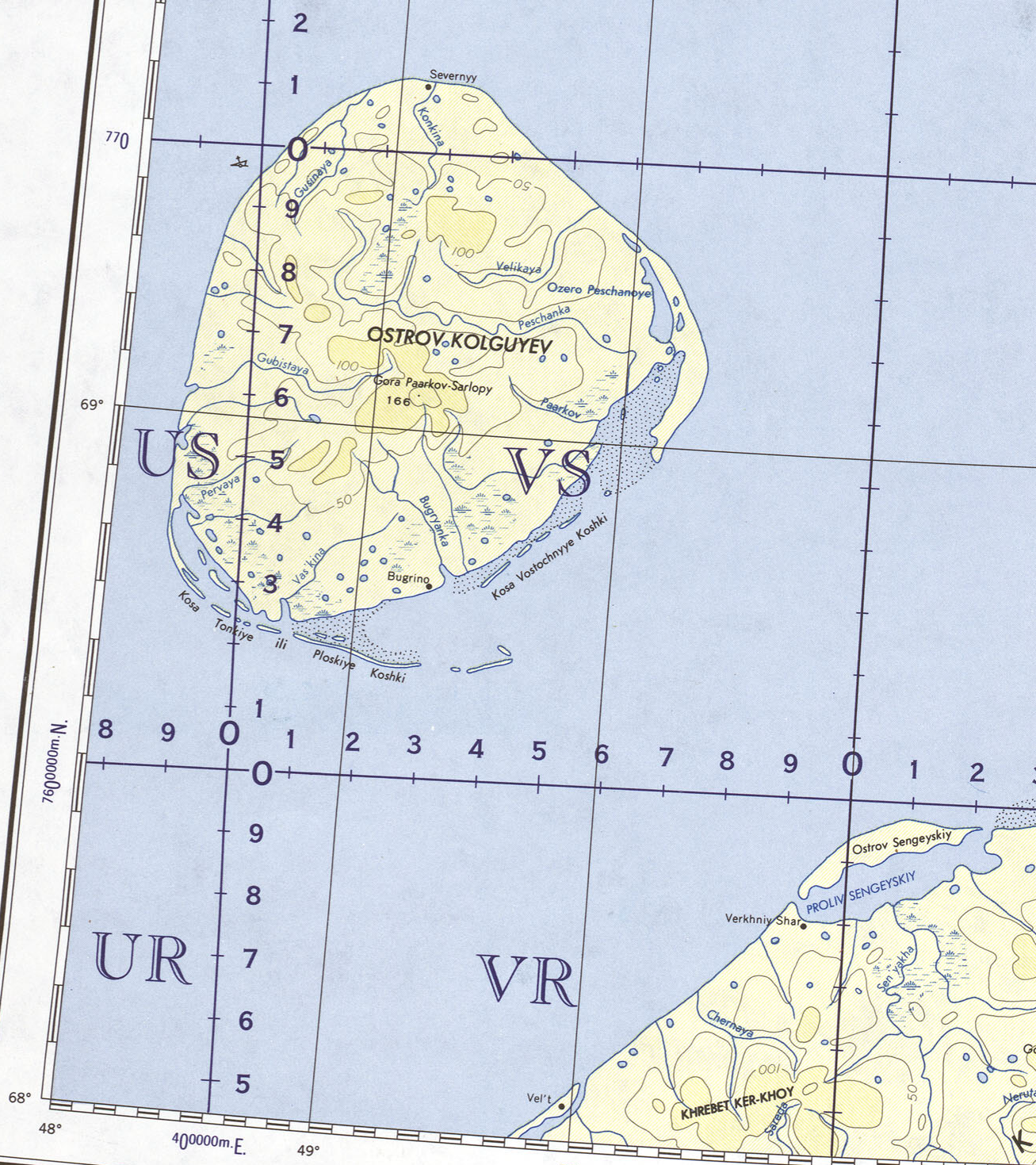
Kolguyev Island
View on WikipediaKolguyev Island (Russian: о́стров Колгу́ев) is an island in Nenets Autonomous Okrug of Russia, located in the south-eastern Barents Sea (west of the Pechora Sea) to the north-east of the Kanin Peninsula.[1]
Key Information


Etymology
[edit]There are different versions about the origin of the insulonym "Kolguev". According to one of them, the name of the island was given by the Pomors in honor of the fisherman Ivan Kalgov, who disappeared without a trace in the waters washing the island. According to another version, the name of the island comes from the ancient Finnic word "kollague", which translates as "triangle" or "triangular".[2]
History
[edit]Kolguyev has been settled for several centuries by Nenets people, who used the island as a base for seal and reindeer hunting, as well as fishing.
The waters around the island was briefly explored by the navigator Willem Barentsz in August 1594.[3]
In 1841, an expedition by the Russian Academy of Sciences under Franz Josef Ruprecht and Professor Saweljaw visited the island in July and August.[3] They circumnavigated the island and briefly explored its interior, reporting on the island.[3]
Report by Trevor-Battye
[edit]The island was explored in 1894 by the British naturalist Aubyn B. R. Trevor-Battye. He landed in June with an assistant, intending to spend about one month studying the wildlife, especially the birds. Due to mechanical problems with the vessel and a misunderstanding, they were left stranded on the island for 12 weeks. He published his study of the natural history and topography of Kolguyev as Ice-Bound on Kolguev (Trevor-Battye 1895). The book includes observations on the Nenets (whom he called Samoyed) who brought their reindeer to the island for summer grazing and to trap geese for trade in Russia.[3] Trevor-Battye eventually left the island with these reindeer herders in September 1894, and had to travel 1,000 miles (1,600 km) overland from the Pechora River to Archangel. He described this journey in A Northern Highway of the Tsar (Trevor-Battye 1898).[4]
Geography and environment
[edit]
The approximately circular-shaped island has a diameter of 80 kilometres (50 mi) and is 3,497 square kilometres (1,350 sq mi) in area. The highest point on the island is at 166 m (545 feet).
There is only one inhabited settlement on the island, Bugrino, located on the southeast coast. Nenets form the majority of the population, with fishing, reindeer farming and trapping being their main economic activities. Oil and gas are also present.[5]
Climate
[edit]Kolguyev Island has a tundra climate (Köppen ET) with an August mean of only 8.3 °C (46.9 °F). February is the coldest month, with a mean of −11.5 °C (11.3 °F). Because of its maritime location, Kolguyev Island experiences seasonal lag. Precipitation is higher in summer and autumn than in winter and spring, with the island receiving 331 millimetres (13.0 in) of precipitation in total.
- Highest temperature: 30.0 °C (86.0 °F) on July 10, 1990
- Lowest temperature: −40.1 °C (−40.2 °F) on February 16, 1951
- Warmest month: 13.0 °C (55.4 °F) in July 2016
- Coldest month: −25.3 °C (−13.5 °F) in February 1998
- Wettest year: 506 millimetres (19.9 in) in 1962
- Driest year: 101 millimetres (4.0 in) in 2017
| Climate data for Kolguyev Island (1991–2020 normals, extremes 1933–present) | |||||||||||||
|---|---|---|---|---|---|---|---|---|---|---|---|---|---|
| Month | Jan | Feb | Mar | Apr | May | Jun | Jul | Aug | Sep | Oct | Nov | Dec | Year |
| Record high °C (°F) | 2.3 (36.1) |
2.2 (36.0) |
2.3 (36.1) |
8.7 (47.7) |
22.1 (71.8) |
27.4 (81.3) |
30.0 (86.0) |
29.2 (84.6) |
22.1 (71.8) |
12.0 (53.6) |
5.8 (42.4) |
4.4 (39.9) |
30.0 (86.0) |
| Mean daily maximum °C (°F) | −7.7 (18.1) |
−8.7 (16.3) |
−6.7 (19.9) |
−3.1 (26.4) |
1.1 (34.0) |
6.7 (44.1) |
11.6 (52.9) |
10.8 (51.4) |
8.0 (46.4) |
2.6 (36.7) |
−1.7 (28.9) |
−4.1 (24.6) |
0.7 (33.3) |
| Daily mean °C (°F) | −10.5 (13.1) |
−11.5 (11.3) |
−9.5 (14.9) |
−5.5 (22.1) |
−1.1 (30.0) |
3.8 (38.8) |
8.3 (46.9) |
8.3 (46.9) |
5.8 (42.4) |
0.9 (33.6) |
−3.8 (25.2) |
−6.5 (20.3) |
−1.8 (28.8) |
| Mean daily minimum °C (°F) | −13.7 (7.3) |
−14.9 (5.2) |
−12.6 (9.3) |
−8.3 (17.1) |
−3.0 (26.6) |
1.8 (35.2) |
5.8 (42.4) |
6.0 (42.8) |
3.7 (38.7) |
−1.3 (29.7) |
−6.5 (20.3) |
−9.4 (15.1) |
−4.4 (24.1) |
| Record low °C (°F) | −37.6 (−35.7) |
−40.1 (−40.2) |
−36.0 (−32.8) |
−31.6 (−24.9) |
−22.5 (−8.5) |
−6.2 (20.8) |
−2.4 (27.7) |
−2.9 (26.8) |
−6.3 (20.7) |
−21.2 (−6.2) |
−27.5 (−17.5) |
−35.5 (−31.9) |
−40.1 (−40.2) |
| Average precipitation mm (inches) | 22 (0.9) |
18 (0.7) |
17 (0.7) |
16 (0.6) |
16 (0.6) |
32 (1.3) |
31 (1.2) |
38 (1.5) |
41 (1.6) |
45 (1.8) |
26 (1.0) |
29 (1.1) |
331 (13) |
| Source: Погода и Климат[6] | |||||||||||||
Flora and fauna
[edit]The island contains many bogs and morainic hills, covered by tundra vegetation. A proposed subspecies of candle larkspur, Delphinium elatum ssp. cryophilum, is found only on this island, but its distinctness from the mainland population is disputed.
The island regularly supports significant populations of barnacle and greater white-fronted geese. It has been recognised as an Important Bird Area (IBA) by BirdLife International.[7]
Fossils of temnospondyl amphibian Wetlugasaurus malachovi were found in the Lower Triassic (Lower Olenekian) deposits near borehole Peschanoozerskaya 35 on this island.[8]
Economy
[edit]The main occupations of the population of the village of Bugrino are reindeer husbandry and fishing. Bugrino is the base of the Kolguevsky industrial complex. In 2013 - 2014, due to the lack of sufficient food on Kolguyev Island, there was a massive death of deer. The livestock decreased from 12,000 to 200-400 heads (according to other sources, up to 50 heads). Four workers remained in the reindeer herding state farm. There are interruptions in the supply of the population.
ArktikNeft is, along with OAO Arktikmorneftegazrazvedka, which specializes in oil exploration, the only continental company that has received a license to operate on the island. Exploration of the island began in 1980. In 1983, the Peschanoozerskoye oil field was discovered.
To date, only oil fields are being exploited. Gas extraction requires the construction of new infrastructures. ArcticNeft conducts all exploration, drilling, extraction, storage and transportation of crude oil. The deposits on the island are of excellent quality, with a very low sulfur content. There are 52 wells in operation (as of November 2002), which extract about 100,000 tons of oil per year.
The transportation of crude oil on the island between different extraction, processing and storage sites is carried out via an oil pipeline. Exports are carried out by sea in summer and autumn: tankers with an average capacity of 30,000 tons are loaded directly into the sea, 5,000 meters from the coast using a floating oil pipeline (siphon). All oil is exported to Rotterdam.
The workforce consists of oil and driller teams, two well service teams, transport personnel and administrative staff. The operation is carried out by two teams of 150 people each, which change every 52 days. The transportation of people and equipment from the island to the continent and back was carried out until the end of 2002 in winter by a helicopter connecting Arkhangelsk, Murmansk or Naryan-Mar with Kolguyev, and in summer and autumn by a steamer plying between Murmansk and the island. Since November 2002, ArcticNeft has had a runway capable of receiving medium-sized aircraft (Yak-40, An-24 and An-26), which the company uses mainly for its own needs, but also for the needs of the rest of the island's population, in particular, residents of the village of Bugrino.
Images
[edit] |
_(14595270719).jpg) |
References
[edit]- ^ GoogleEarth - Location
- ^ "Остров Колгуев | Острова мира". ostrov-mira.ru. Retrieved 2021-12-16.
- ^ a b c d Trevor-Battye, Aubyn. (1895). Ice-bound on Kolguev, Constable, London, 1895.
- ^ Trevor-Battye, Aubyn. (1898). A Northern Highway of The Tsar, Constable, London, 1898.
- ^ "Kolguyev oil changes hands". The Independent Barents Observer. Retrieved 30 March 2021.
- ^ "平年値(年・月ごとの値) 主な要素". Погода и Климат. Retrieved 16 February 2022.
- ^ "Kolguev Island". BirdLife Data Zone. BirdLife International. 2024. Retrieved 2024-08-23.
- ^ Novikov A.V. (2018). Early Triassic amphibians of Eastern Europe: evolution of dominant groups and peculiarities of changing communities (PDF) (in Russian). Moscow: RAS. p. 290. ISBN 978-5-906906-71-7. Archived from the original on 2023-12-08. Retrieved 2024-02-03.
{{cite book}}: CS1 maint: bot: original URL status unknown (link) CS1 maint: publisher location (link)
External links
[edit]Kolguyev Island
View on GrokipediaName and administration
Etymology
The name of Kolguyev Island, known in Russian as остров Колгуев (Ostrov Kolguyev), is believed to derive from one of two primary theories rooted in historical linguistic traditions. According to local Pomor folklore, the island was named in honor of Ivan Kalgov, a prominent 18th-century fisherman from the Pomor community who reportedly disappeared without trace in the surrounding waters of the Barents Sea, with his fellow seafarers commemorating him by applying his name to the landmass.[6] An alternative explanation traces the name to an ancient Finnic term, "kollague" (or "kollagwe"), which translates to "triangle" or "triangular," a reference to the island's roughly triangular shape when viewed from above.[6] This etymology aligns with broader Finnic influences in the naming of Arctic features, given historical migrations and interactions in the region. In English transliterations, the name has varied historically as "Kolguyev," "Kolguev," or "Kalguyev," reflecting differences in phonetic rendering from the Russian Cyrillic.[7] The form "Kolguyev" became standardized on official maps and in geographical literature following the 19th century, particularly after Russian cartographic surveys solidified its usage in imperial and Soviet-era documentation.[7]Administrative status
Kolguyev Island is administratively part of the Nenets Autonomous Okrug, a federal subject within Arkhangelsk Oblast in northwestern Russia. This status dates to the Soviet reorganization of July 15, 1929, when the Nenets National Okrug was established to consolidate territories inhabited by the Nenets people, including the island.[8][9] The island's administration is conducted remotely from Naryan-Mar, the capital of the Nenets Autonomous Okrug, approximately 200 kilometers to the southwest on the mainland. Local governance is centered in Bugrino, the island's sole inhabited settlement and administrative hub, managed through the Kolguyev rural council, which handles basic community affairs under the oversight of the okrug authorities.[10][11] As a territory traditionally used by the Nenets people, Kolguyev falls under special protections for indigenous lands outlined in Russian federal legislation, notably Federal Law No. 82-FZ of April 30, 1999, "On Guarantees of the Rights of the Indigenous Small-Numbered Peoples of the Russian Federation." This law establishes rights to territories of traditional nature use, enabling indigenous communities in the okrug to maintain cultural and economic practices on the island amid post-Soviet reforms.[12][13]Geography
Location and physical features
Kolguyev Island lies in the southeastern portion of the Barents Sea, part of the Nenets Autonomous Okrug in northwestern Russia, approximately 70 km north of the Kanin Peninsula along the Eurasian mainland coast. Its approximate central coordinates are 69°05′N 49°15′E. The island is separated from the continent by a shallow strait and is positioned west of the Pechora Sea, contributing to its remote Arctic setting on the continental shelf.[1] With a total area of 5,130 km², the island exhibits a roughly circular shape and a diameter of about 80 km. This compact form encloses a low-relief terrain dominated by an accumulative plain, where elevations generally range from 20 to 30 m above sea level on average. The highest elevation reaches 166 m at a prominent morainic hill, underscoring the subdued topography typical of post-glacial Arctic landmasses.[1] The physical landscape features extensive flat tundra interspersed with peat bogs, swamps, and low hills, shaped primarily by Pleistocene glaciation during the Last Glacial Maximum when the island was covered by massive ice sheets from the Scandinavian and Barents-Kara systems. These glacial processes deposited Quaternary sediments, including till that forms the morainic features and fosters the development of wetland complexes. Numerous small lakes and river valleys punctuate the surface, resulting from glacial erosion and post-glacial drainage patterns.[1]Hydrology and geology
Kolguyev Island features a well-developed hydrological system characterized by numerous shallow thermokarst lakes that predominate across the landscape, many of which freeze to the bottom during winter.[14] Deeper glacial lakes with sandy shores occur in higher elevations, while rivers such as the 150 km-long Peschanka River traverse the island from northwest to southeast, forming wide deltas near the coast.[14] These water bodies are primarily fed by snowmelt and precipitation, with no significant groundwater contributions due to the permafrost layer.[14] Peat bogs cover approximately 38% of the island's interior, particularly sedge and cotton grass types in river valleys and the southern coastal lowlands, contributing to the region's wetland-dominated hydrology.[14] Geologically, the island is underlain by unconsolidated Quaternary sediments of Pleistocene and Holocene age, which mantle older Mesozoic strata exposed in limited outcrops and accessed via boreholes.[15] Beneath these, Triassic paralic clastic rocks, including sandstones deposited in coastal plain, deltaic, and nearshore marine environments, form the primary subsurface structure.[15] Evidence of oil-bearing strata within these Triassic layers was first discovered in the early 1980s through exploratory drilling at the Peschanoozerskoye field.[16] Oil extraction from these strata has been ongoing since the mid-1980s.[16] The island's sedimentary layers preserve notable fossil records from the Early Triassic period, including remains of marine reptiles such as the prolacertiform Boreopricea funerea, recovered from borehole samples at depths around 1,112 meters.[17] These fossils, alongside other Early Triassic vertebrates like Orenburgia and additional prolacertids, are unique to Kolguyev's subsurface exposures and provide insights into post-Permian recovery in high-latitude marine ecosystems.[18]Climate
General characteristics
Kolguyev Island features a tundra climate, classified as ET under the Köppen-Geiger system, characteristic of the broader Barents Sea region where polar conditions prevail due to the influence of Arctic air masses and oceanic moderation.[19] Historical meteorological records from the Bugrino station indicate average temperatures of 8.3°C in August, the warmest month, and -11.5°C in February, the coldest, based on data spanning 1961-1990.[20] Annual precipitation averages 331 mm, predominantly occurring as rain during the summer months when warmer temperatures facilitate convective activity.[20] The island's short growing season, typically lasting 2-3 months, is constrained by persistent low temperatures and widespread permafrost coverage, which underlies much of the terrain and restricts soil thawing.[19] Proximity to the Barents Sea contributes to frequent fog formation from sea ice contrasts and strong winds driven by westerly storm tracks, enhancing maritime influences on local weather patterns.[19] These climatic conditions shape the island's sparse tundra vegetation, limiting plant growth to hardy species adapted to brief summers (detailed in Environment > Flora).[19]Recent changes and impacts
Since the 1990s, the annual mean temperature on Kolguyev Island and the surrounding Russian Arctic has risen by approximately 1.5°C, with monitoring data from 2020 to 2024 indicating accelerated warming rates exceeding 0.4°C per decade in the Barents Sea region.[21] This trend aligns with broader Arctic amplification, where recent years have shown temperature anomalies up to 1.2°C above the 1991–2020 baseline.[21] Concurrently, the frequency of intense storms has increased due to reduced sea ice extent, exacerbating weather extremes in the southeastern Barents Sea.[22] These warming trends have driven significant permafrost thaw and coastal erosion on Kolguyev Island, with mega retrogressive thaw slumps retreating at rates of several meters per year along the western coast.[23] A 2024 biota monitoring study emphasizes accelerated environmental changes in the western Russian Arctic sector, including hydrological shifts from thawing permafrost that alter tundra ecosystems and amplify abrasion processes, leading to annual coastal losses of up to 2 meters on the island.[23][24] Such degradation contributes to broader ecological disruptions, including a noted decline in local reindeer populations linked to habitat alterations.[23] Projections from Arctic climate models indicate continued increases in annual precipitation in the region by 2050, potentially intensifying thaw cycles and erosion while shifting seasonal patterns.[25] These forecasts underscore the need for enhanced monitoring to mitigate impacts on island infrastructure and biota.[26]Environment
Flora
The flora of Kolguyev Island exemplifies Arctic tundra ecosystems, where low-growing vegetation is adapted to harsh conditions of permafrost, short growing seasons, and nutrient-poor soils. Dominant plant communities consist primarily of mosses, lichens, sedges, and dwarf shrubs, forming a mosaic of open tundra landscapes. Key species include black crowberry (Empetrum nigrum), dwarf birch (Betula nana), and various mosses such as Dicranum spp., which contribute to the characteristic dwarf shrub-moss-lichen tundra prevalent across the island's plateau at elevations of 50–80 m.[27] These plants form dense mats that stabilize the soil and support limited biodiversity in this subarctic environment. Extensive peat bogs are a prominent feature, especially in the southern lowlands, where waterlogged conditions foster wet tundra with sedge-dominated mires and polygonal wetlands. These bogs cover significant portions of the island, accumulate organic matter slowly due to cold temperatures, creating thick layers of peat that influence local hydrology and carbon storage.[28] The presence of such mires enhances habitat heterogeneity, allowing for slight variations in sedge and grass communities amid the otherwise uniform tundra cover. A notable aspect of the island's flora is the proposed subspecies Delphinium elatum ssp. cryophilum (candle larkspur), an endemic form restricted to the morainic hills and identified in the 1890s during early botanical explorations. This blue-flowered perennial thrives in the gravelly, well-drained slopes of these glacial features, representing a unique genetic adaptation within the broader Delphinium elatum complex.[29] Seasonal dynamics are pronounced, with a brief summer blooming period from late June to August enabling growth and reproduction under continuous daylight. During this window, a diverse array of vascular plant species have been documented through comprehensive surveys, highlighting the island's relatively rich phytodiversity for an Arctic locale despite the dominance of non-vascular elements. These blooms feature colorful displays of sedges, forbs, and dwarf shrubs, transitioning abruptly to dormancy as temperatures drop.[30]Fauna
Kolguyev Island's fauna is characterized by Arctic tundra species adapted to its harsh environment, with a strong emphasis on avian populations that have led to its designation as a nature reserve in 2019 to protect biodiversity in the Barents Sea region.[31] The island supports a mix of terrestrial mammals, migratory birds, and marine life influenced by surrounding waters, though overall densities remain low due to the absence of rodents and limited prey resources.[32] Among mammals, semidomestic reindeer (Rangifer tarandus) form a key component, with populations historically managed by indigenous Nenets herders; however, a dramatic collapse occurred between 2012 (over 12,000 individuals) and 2016 (only 153 remaining), attributed to disease and overgrazing, though numbers have since begun recovering to around 2,000 as of 2021.[33][34] Arctic foxes (Vulpes lagopus) are present in low breeding densities, typically measured as a few pairs per 100 km², relying on geese and reindeer carrion for sustenance in the rodent-free ecosystem.[35] Red foxes (V. vulpes) occur even more sparingly, with stable but minimal breeding numbers.[35] The island's birdlife is particularly diverse and internationally significant, recognized as an Important Bird and Biodiversity Area (IBA) by BirdLife International due to its role as a breeding and staging ground for waterfowl.[36] A total of 111 bird species have been recorded, including 58 nesting species, with long-term monitoring from 2006 to 2019 revealing shifts toward more widespread and Siberian taxa while Arctic specialists like dunlins (Calidris alpina) have declined in abundance.[32] Brent geese (Branta bernicla) were once numerous but nearly vanished by the late 20th century, whereas barnacle geese (B. leucopsis) have seen sharp increases since the 1980s, supporting up to 75,000 breeding pairs as of 2006–2008.[36][32] These populations underscore the island's high conservation value under criteria for globally significant congregations of waterbirds.[36] Marine influences extend to the surrounding Barents Sea waters, where seals such as ringed seals (Pusa hispida) and various fish species support local ecosystems and traditional livelihoods, though no large marine predators are resident on the island itself.[37] Traditional hunting practices, including for seals and birds, have historically impacted populations but are now regulated within the protected area framework.[31]History
Indigenous settlement
The Nenets people, a Samoyedic ethnic group indigenous to the Russian Arctic, have maintained a presence on Kolguyev Island for several centuries, utilizing it primarily as a base for seasonal hunting camps as part of their broader nomadic lifestyle in the region. Archaeological and historical evidence indicates that the Nenets' ancestral territories along the Barents and Kara Seas, including offshore islands like Kolguyev, have been occupied for over 2,000 years, with continuous seasonal exploitation of the island's resources supporting their subsistence economy. By the 19th century, habitation had become more year-round for some families, though traditional patterns of mobility persisted.[38][39] Traditional activities on the island centered on hunting marine mammals such as seals and walruses, as well as birds like geese and reindeer, with fishing for species including salmon trout in rivers like the Gusina and Kriva playing a key role from at least the 16th century onward. Nenets oral histories recount interactions with Pomor traders from the mainland, who exchanged goods like flour and cotton for furs, feathers, and pastured reindeer, fostering economic ties that integrated the island into regional networks. These narratives, passed down through songs and stories, emphasize the island's sacred sites, such as the Holy Hill of Num, and highlight adaptive practices like using snares, dogs, and driftwood for tools and shelters.[40][41] In the 19th century, an 1857 inquiry by the Arkhangelsk Military Governor estimated up to 200 Nenets and their families lived on Kolguyev and nearby islands, reflecting a stable pre-industrial community dispersed in chooms (traditional tents) across the tundra. This figure underscores the island's role as a self-sustaining outpost amid harsh Arctic conditions, with most inhabitants born locally and reliant on local resources for survival. The pre-industrial population remained relatively stable, supported by communal hunting expeditions that could yield thousands of birds in a single season.[42][40] During the Soviet era, collectivization policies in the 1920s and 1930s disrupted traditional Nenets practices by enforcing state control over reindeer herding, targeting shamans, and implementing anti-wolf campaigns, yet the community resisted through preservation of oral traditions and sacred sites.[3]Exploration and development
The first recorded European sighting of Kolguyev Island occurred during the Dutch navigator Willem Barentsz's expedition in search of a Northeast Passage in 1594, when his ship sailed near the island's southwest coast, identifying it as "Colgoyeu" based on earlier charts. In 1841, the Russian Academy of Sciences dispatched an expedition led by botanist Franz Josef Ruprecht and Professor Karl Saweljaw (also spelled Savelyev) to conduct a scientific survey of the island's flora, fauna, and geology during July and August. The team landed at the mouth of the Vaskina River and Stanovoy Sharok, spending 16 days ashore despite 10 days of stormy weather that restricted their movements; Ruprecht's collections contributed to his 1845 publication Flores Samoyedorum cisuralensium, documenting key plant species like Ranunculus lapponicus.[43] A significant personal exploration came in 1894 when British traveler and naturalist Aubyn Trevor-Battye, en route to Novaya Zemlya, became stranded on Kolguyev due to ice after his yacht The Narwhal was trapped near the island's east coast in late summer. Over the following months, Trevor-Battye lived among the Nenets indigenous people, documenting their ethnography, reindeer herding practices, and social customs in detail; his experiences formed the basis of the 1895 book Ice-Bound on Kolguev: A Chapter in the Exploration of Arctic Europe, which also included observations on the island's natural history and provided one of the earliest comprehensive outsider accounts of Nenets life on the island. During the Soviet era, Kolguyev saw limited development until the discovery of oil reserves in 1982 on the island's east coast at the Peschanoozerskoye field, announced by Soviet authorities following exploratory drilling that confirmed viable hydrocarbon deposits.[15] This led to the field's initial production starting in 1987, marking the island's entry into resource extraction. In the 1990s, Nenets communities opposed oil exploration near the sacred Yarto Lake, successfully relocating a drilling rig to protect the site.[3] Following the dissolution of the Soviet Union in 1991, the oil operations underwent privatization, with licenses awarded to private entities; by the mid-1990s, the field was operated by ZAO Arktikneft (later Arctic Oil Company Ltd.), enabling expanded development including the construction of a runway in November 2002 capable of accommodating medium-sized aircraft to support logistics.[33][44]Demographics
Population trends
The population of Kolguyev Island has experienced a steady decline over recent decades, reflecting broader demographic challenges in remote Arctic regions. Regional reports indicate the island's resident population was around 446 as of the early 2020s, down from approximately 400 in 2002.[45] This reduction is attributed primarily to outmigration driven by limited economic opportunities and the shift from traditional reindeer herding to oil-related employment, which often requires relocation to mainland facilities. Historical records suggest fluctuations during periods of resource exploration, though specific peaks are not well-documented. The island's demographics remain predominantly indigenous, with Nenets comprising the majority of residents. This high proportion underscores the Nenets' historical ties to the island as a base for hunting, fishing, and herding, though economic transitions have accelerated youth outmigration to urban centers in the Nenets Autonomous Okrug. The population structure is relatively youthful but faces vulnerabilities from low birth rates and elder care needs in an isolated setting.[46]Settlements and indigenous culture
Bugrino serves as the primary and only permanent settlement on Kolguyev Island, located on its southeast coast and home to the majority of the island's Nenets inhabitants. Established in the 1930s as part of Soviet efforts to sedentarize nomadic populations, the village features wooden cabins that replaced traditional chums, along with essential infrastructure including a boarding school and a clinic originally built as a hospital in the 1920s-1930s.[47] These facilities support daily life amid the island's remote conditions, where helicopter transport provides irregular links to the mainland every two to three weeks.[47] The indigenous Nenets culture on Kolguyev centers on reindeer nomadism, though it has transitioned to a rotational shift-herding system involving about 30 men who alternate between the village and tundra pastures for three- to four-week periods. Traditional shamanistic beliefs, featuring sacred sites like Seĭ korkha marked by syadeĭ idols, persist in oral narratives and are often likened by locals to Orthodox icons, reflecting a historical syncretism with Russian Orthodoxy introduced during settlement.[41] Since the 2010s, language preservation efforts in the Nenets Autonomous Okrug have included educational programs teaching Tundra Nenets in schools, folklore groups, and digital resources like online portals, helping maintain the language among herders who use it for place names and traditional knowledge.[48] Community life revolves around seasonal tundra migrations and rituals at sacred sites, which echo broader Nenets practices such as spring gatherings tied to herding cycles, fostering intergenerational transmission of customs despite settlement pressures. Isolation exacerbates challenges in education, with children attending boarding schools in Bugrino or Naryan-Mar that prioritize Russian-language curricula, leading to cultural erosion and reduced tundra knowledge among youth. Health outcomes are similarly strained, with high tuberculosis rates linked to remoteness and limited access to advanced care, compounded by demographic shifts from nomadic lifestyles.[41][49]Economy
Traditional livelihoods
The traditional livelihoods of the Nenets indigenous population on Kolguyev Island center on reindeer husbandry, which has long provided essential resources such as meat, hides for clothing and shelter, and draft animals for transport across the tundra. Herding practices involve seasonal migrations to optimize grazing on the island's limited pastures, with families managing semi-nomadic camps during summer and consolidating near settlements in winter. The reindeer population peaked at over 12,000 in 2012, supporting multiple herding brigades and contributing to the cultural identity of the Nenets through language and rituals tied to animal care.[33][34] However, the herd experienced a severe collapse between 2013 and 2016, dropping to just 153 animals by 2016 due to overgrazing from overpopulation, mismanagement of pastures, and extreme weather events including recurrent thaws followed by deep snow and ice layers that blocked access to lichen forage. These climate-related factors, exacerbated by the island's isolation, led to mass starvation and the shutdown of the main herding cooperative in 2017, severely impacting food security and traditional practices for the roughly 400 Nenets residents.[50][51] Fishing and hunting serve as vital supplements to herding, focusing on marine resources in the Barents Sea. Nenets hunters target ringed seals during the spring ice breakup using harpoons and boats, while fishing for cod and Atlantic salmon occurs seasonally from late spring through summer, coinciding with fish migrations and ice melt that opens coastal access. These activities employ traditional techniques like gillnets and ice fishing in winter, providing protein and trade goods while adhering to sustainable quotas based on environmental cues.[50][52] Post-2020 recovery initiatives have revitalized reindeer husbandry through a decade-long ban on commercial slaughter implemented in 2020 to rebuild stocks, resulting in a herd size of approximately 2,000 as of 2021 via natural reproduction and limited imports from the mainland, with no publicly available updates as of 2025. Community-led cooperatives, reformed amid ongoing climate challenges like delayed ice formation and increased storm frequency, now emphasize sustainable pasture rotation and diversified harvesting to balance traditional needs with environmental resilience. Oil operations on the island have emerged as an alternative employment source, drawing some herders into wage labor during off-seasons.[34][50]Resource extraction
The primary resource extraction activity on Kolguyev Island centers on the Peschanoozerskoye oil and gas condensate field, discovered in 1983 through exploratory drilling that identified significant hydrocarbon deposits in Lower Triassic sandstone reservoirs.[15] Operations commenced in the late 1980s, with 52 wells becoming operational by the early 2000s to support extraction. Production peaked at approximately 100,000 tons of light crude oil per year during that period, all of which was transported by tanker to Rotterdam for refining and distribution.[53][54] By 2015, the field had 64 wells drilled in total, including 24 active producing wells and 7 water injection wells to maintain reservoir pressure.[55] Ownership of the field transitioned in 2016 when Arcticneft, the operating company, was acquired by Urals Energy Public Company Limited, a Russian firm focused on Arctic upstream activities.[56] In 2019, parts of Kolguyev Island were designated as the Kolguyevsky Nature Reserve, which allows for the continuation of traditional industries like reindeer herding and fishing while providing environmental protections, though oil operations continue in non-protected areas.[56] Recoverable reserves for the Peschanoozerskoye field were estimated at 16 million barrels of oil equivalent in assessments around 2019, equivalent to roughly 2.5 million tons, though broader evaluations of the island's fields suggest higher potential remaining volumes of 5-10 million tons as of 2023 based on low depletion rates.[57] Infrastructure developed for these operations includes pipelines for crude transport to coastal loading points and an airstrip to support logistics and personnel movement, enhancing connectivity in the remote Arctic setting.[54] Resource extraction has introduced environmental and social challenges, with oil activities imposing technogenic stresses on the island's fragile tundra ecosystems through risks of pipeline leaks, waste discharges, and occasional spills, such as a diesel fuel incident reported in 2018.[54] These developments have also conflicted with traditional reindeer herding practices, as oil infrastructure and exploration claims occupy key pasture lands essential for Nenets herders' migratory routes, exacerbating tensions over land use documented in reports from the late 2010s and early 2020s.[58]References
- https://en.wikisource.org/wiki/1911_Encyclop%C3%A6dia_Britannica/Kolguev