
Community hub
Recent from talks
Contribute something
Nothing was collected or created yet.
Krishnarajanagara
View on Wikipedia
Krishnarajanagara is a town in Mysore district in the Indian state of Karnataka. It is also the administrative center of Krishnarajanagara Taluk.
Key Information


Geography
[edit]Krishnarajanagara is located on the northern part of Mysore district, west of the Krishna Raja Sagara Reservoir. It has an average elevation of 786 metres above sea level.[1] NH-373, also known as SH-57 passes through the town of K.R.Nagara.
Climate
[edit]Krishnarajanagara has Tropical Savanna Climate under the Köppen climate classification. On average, the town receives the least amount of rainfall in January, and the most in October.

| Climate data for Krishnarajanagara | |||||||||||||
|---|---|---|---|---|---|---|---|---|---|---|---|---|---|
| Month | Jan | Feb | Mar | Apr | May | Jun | Jul | Aug | Sep | Oct | Nov | Dec | Year |
| Mean daily maximum °C (°F) | 28 (82) |
30.2 (86.4) |
32.4 (90.3) |
32.7 (90.9) |
30.8 (87.4) |
26.7 (80.1) |
25.5 (77.9) |
25.7 (78.3) |
26.8 (80.2) |
26.8 (80.2) |
26.3 (79.3) |
26.5 (79.7) |
28.2 (82.7) |
| Daily mean °C (°F) | 21.8 (71.2) |
23.7 (74.7) |
25.9 (78.6) |
26.4 (79.5) |
25.3 (77.5) |
23 (73) |
22.3 (72.1) |
22.2 (72.0) |
22.6 (72.7) |
22.5 (72.5) |
21.8 (71.2) |
21.1 (70.0) |
23.2 (73.8) |
| Mean daily minimum °C (°F) | 15.8 (60.4) |
17.4 (63.3) |
19.7 (67.5) |
21.6 (70.9) |
21.6 (70.9) |
20.8 (69.4) |
20.4 (68.7) |
20.1 (68.2) |
19.8 (67.6) |
19.2 (66.6) |
17.8 (64.0) |
16.1 (61.0) |
19.2 (66.5) |
| Average rainfall mm (inches) | 3 (0.1) |
4 (0.2) |
11 (0.4) |
48 (1.9) |
106 (4.2) |
129 (5.1) |
126 (5.0) |
106 (4.2) |
99 (3.9) |
151 (5.9) |
70 (2.8) |
20 (0.8) |
873 (34.5) |
| Source: Climate-Data.org[2] | |||||||||||||
Demographics
[edit]According to the 2011 India census, Krishnarajanagara had a population of 35,805. Its gender ratio is relatively balanced, with 17,900 male residents and 17,905 female residents. Krishnarajanagara has an average literacy rate of 78.2%. with male literacy being 81.8%, and female literacy being 74.5%. In Krishnarajanagara, 9.9% of the population is under 6 years of age.[3]
Galleries
[edit]-
 Taluk boundary before creation of Saligrama Taluk
 -
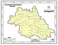 Taluk boundary same as Assembly Constituency as per 2011 Census before creation of Saligrama Taluk
 -
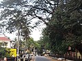 C.M. Road within the town
 -
 Kandenahalli Bridge on the northeast of the town
_2011.jpg)
_Vidhana_Sabha_Constituency.jpg)


See also
[edit]References
[edit]- ^ "Krishnarajanagara topographic map, elevation, terrain". Topographic maps. Retrieved 22 March 2023.
- ^ "Krishnarajanagara climate: Temperature Krishnarajanagara & Weather By Month - Climate-Data.org". en.climate-data.org. Retrieved 22 March 2023.
- ^ "Basic Population Figures of India, States, Districts, Sub-District and Village, 2011". Retrieved 21 March 2023.
This article related to a location in Mysore district, Karnataka, India is a stub. You can help Wikipedia by expanding it. |
Krishnarajanagara
View on GrokipediaHistory
Founding and early development
Krishnarajanagara originated from the catastrophic flooding of the Kaveri River in 1924, which severely damaged the nearby town of Yedatore (also known as Hale Yedatore or Yadathore), rendering much of it uninhabitable and prompting the need for relocation.[6][7] The flood's devastation, including the destruction of homes and infrastructure, led the Kingdom of Mysore to initiate planning for a new settlement to resettle the affected population and ensure long-term safety from river overflows.[8] In response, Maharaja Krishnaraja Wodeyar IV oversaw the founding of Krishnarajanagara between 1925 and the 1930s as a planned replacement township, named in his honor to commemorate his visionary leadership during the reconstruction efforts.[7] The new town was strategically located on higher ground, approximately 3-5 kilometers from the original site, between the Kaveri River and the Krishna Raja Sagara Dam, with development commencing in the late 1920s following initial surveys and land allocation starting around 1925.[9] This relocation not only addressed immediate humanitarian needs but also aligned with broader regional development goals under the Mysore Kingdom, particularly in anticipation of submersion risks from the dam's reservoir. The early infrastructure of Krishnarajanagara was designed as a model riverside town, featuring a grid-like layout with wide streets, residential zones, administrative buildings, and irrigation channels to support agriculture as the primary economic focus.[7] Administrative offices were prioritized to facilitate governance, while agricultural plots were allocated to promote paddy cultivation and other crops, leveraging the fertile Cauvery basin. The initial population influx primarily consisted of displaced residents from Yedatore, numbering in the hundreds, who were provided land grants and housing incentives as part of a structured resettlement program that helped stabilize the region post-flood.[9] This foundational phase laid the groundwork for Krishnarajanagara's growth into a key administrative and agrarian hub.Historical significance
The area encompassing modern Krishnarajanagara, originally known as Yedatore, traces its historical roots to the 13th century with the establishment of the Yadathore Shri Yoganandeshwara Saraswati Math by Shri Shri Yoganandeshwara Saraswati Mahaswamiji along the banks of the Kaveri River.[6] By the 14th century, the region fell under the domain of the Vijayanagara Empire, which governed much of southern Karnataka, including Mysore territories, fostering local agricultural production and river-based trade networks that supported settlements like Yedatore.[10] Krishnarajanagara's founding reflects the transformative policies of Maharaja Krishnaraja Wodeyar IV during his reign from 1902 to 1940, a period noted for infrastructure advancements in the Kingdom of Mysore. Central to this was the Krishna Raja Sagara (KRS) Dam, initiated in 1911 and completed in 1932 under the Maharaja's oversight with engineer Sir M. Visvesvaraya, designed primarily to irrigate arid lands in Mysore and Mandya districts and combat famines.[1] The dam's reservoir backwaters submerged much of Yedatore, prompting its rehabilitation as the planned town of Krishnarajanagara between 1925 and the 1930s, explicitly named after the Maharaja to honor his visionary leadership.[1] This relocation was accelerated by the severe flood of 1924 that damaged the original settlement, including the math, which was subsequently rebuilt in the new town, along with other notable structures such as the Arkeshwara Temple dedicated to Lord Shiva.[6][1] The town's layout, crafted by German architect Gustav Hermann Krumbiegel, incorporated resilient urban planning to mitigate future flood risks, symbolizing the Mysore Kingdom's emphasis on modern engineering and sustainable development.[1] Following India's independence in 1947, the Kingdom of Mysore acceded to the Union, integrating Krishnarajanagara into the Mysore State (renamed Karnataka in 1973) as a key administrative node. It emerged as the headquarters of Krishnarajanagara Taluk, managing governance for multiple hoblis and villages in the region.[1] Overall, Krishnarajanagara embodies the Mysore Kingdom's legacy of modernization, particularly through irrigation innovations like the KRS Dam that enhanced agricultural viability and through deliberate urban redesign for flood resilience, influencing the area's enduring role in regional development.[1]Geography
Location and topography
Krishnarajanagara, also known as K.R. Nagar, is situated in the northern part of Mysore district in Karnataka, India, at coordinates 12°26′14″N 76°22′50″E. The town lies approximately 40 km north of Mysore city and is positioned west of the Krishna Raja Sagara (KRS) Reservoir, forming part of the broader Mysore district boundaries. It sits at an elevation of 786 meters above sea level, contributing to its moderate highland setting within the Cauvery River basin.[11][12] The town covers an area of 8.6 km², while the surrounding Krishnarajanagara taluk encompasses a rural area of 596.02 km², characterized by a mix of agricultural plains and undulating terrain. This taluk is entirely within Mysore district, bordered by neighboring taluks such as Hunsur to the west and Periyapatna to the north, with the KRS Reservoir influencing its eastern limits. The landscape is shaped by the proximity to the Western Ghats, which extend rainfall and river systems into the region, creating a transitional zone between the ghats' foothills and the [Deccan Plateau](/page/Deccan Plateau).[13][14] Topographically, Krishnarajanagara is located along tributaries of the Kaveri River, featuring flat expanses of paddy fields interspersed with gentle hills rising to elevations between 750 and 830 meters. The soil profile predominantly consists of red loamy and clayey types derived from granitic-gneiss and schistose rocks, which are well-suited for agriculture due to their fertility and water retention properties. Natural features include the nearby KRS Dam, constructed between 1911 and 1932 for irrigation purposes, which has significantly altered local hydrology by channeling water from the Kaveri and its tributaries into the surrounding plains. The regional landscape bears the influence of the Western Ghats through subtle elevational variations and riverine drainage patterns that support fertile alluvial deposits.[15][16][17]Climate
Krishnarajanagara features a tropical savanna climate (Köppen Aw), characterized by distinct wet and dry seasons typical of southern Karnataka's inland regions.[18] The area's annual mean temperature averages 23.2 °C, with total precipitation reaching 873 mm. Rainfall is highly seasonal, peaking during the northeast monsoon in October at 151 mm and dropping to a minimum of 3 mm in January.[19] Seasonal patterns include the southwest monsoon from June to September, which delivers heavy rains essential for the region's hydrology; dry winters from December to February with mild temperatures and low humidity; and hot summers from March to May, when daytime highs often exceed 35 °C.[20] The nearby Krishnarajasagara (KRS) Dam exerts a positive influence on the local microclimate by enabling extensive irrigation, which sustains agricultural productivity and moderates temperature extremes through increased soil moisture. Additionally, the dam's infrastructure has historically mitigated occasional floods by regulating river flows during heavy monsoon periods.Demographics
Population statistics
According to the 2011 Census of India, Krishnarajanagara town had a total population of 35,805, comprising 17,900 males and 17,905 females, resulting in a sex ratio of 1,000 females per 1,000 males.[21] The town's population density was approximately 4,162 inhabitants per square kilometer, calculated over its urban area of 8.6 square kilometers.[21][22] In the broader Krishnarajanagara taluk, the total population stood at 252,657, with the rural portion accounting for 216,852 residents after subtracting the urban town population.[23] The age distribution in the town indicated a relatively young demographic, with children under 6 years comprising 9.9% of the population, or 3,542 individuals (1,826 males and 1,716 females).[21] Literacy rates were notably high for an urban center in the region, reaching 86.7% overall, with male literacy at 91.1% and female literacy at 82.4%.[24] Population growth in Krishnarajanagara has been steady since its establishment in the early 20th century as a planned settlement linked to the Krishna Raja Sagara dam project, reflecting broader urbanization trends in Mysore district.[25] Historical census figures show the town expanding from 26,084 residents in 1991 to 30,603 in 2001, and further to 35,805 in 2011, representing an average decadal growth rate of about 17% between 2001 and 2011.[26] As the administrative hub of the taluk, the town continues to attract migrants from surrounding rural villages, contributing to ongoing urban expansion; estimates project the town's population to reach approximately 50,000 by 2025.[21]Languages and religion
Krishnarajanagara's linguistic landscape is dominated by Kannada, the official language of Karnataka, which serves as the primary medium for administration, education, and daily communication among the majority of residents. According to 2011 Census data for the surrounding Mysore district, Kannada is the mother tongue for approximately 80-85% of the population in rural talukas like Krishnarajanagara, reflecting its deep-rooted prevalence in the region's cultural and social fabric. Minority languages such as Urdu, Telugu, and Tamil are also spoken, primarily by communities resulting from historical migration from neighboring states and urban centers, often used in trade, family settings, and local festivals.[27] Religiously, the area is predominantly Hindu, with over 90% of the population adhering to Hinduism as per the 2011 Census for Krishnarajanagara taluka, where Hindus number 239,656 out of a total of 252,657 residents.[23] Muslim communities form the largest minority at 4.3% (10,862 individuals), followed by Christians at 0.3% (763), Jains at 0.27% (689), and negligible numbers of Sikhs, Buddhists, and others.[23] This composition underscores the strong influence of Shaivite traditions, particularly among Lingayat followers, and Vaishnavite practices within the broader Hindu majority, shaping local customs and community interactions.[28] The social structure in Krishnarajanagara draws from Mysore district norms, with significant influences from the Vokkaliga and Lingayat communities, which together represent key agricultural and socio-economic groups in the region. Vokkaligas, comprising around 24% of local demographics based on voter composition estimates, are prominent in farming and landholding, while Lingayats account for about 8%, contributing to religious and entrepreneurial activities.[29] These communities, alongside Scheduled Castes (15%) and Scheduled Tribes (7%), reflect the area's diverse yet interconnected caste dynamics rooted in Karnataka's historical agrarian society.[23]Economy
Agriculture
Agriculture is the dominant economic sector in Krishnarajanagara taluk, employing approximately 58% of the total workforce, with 50,513 cultivators and 22,458 agricultural laborers reported in the 2011 census.[23] This rural economy centers on farming, supported by the taluk's fertile clayey soils derived from granitic-gneisses and schistose rocks, which are well-suited for water-intensive crops.[16] Paddy remains the principal crop, covering about 40% of the geographical area during the kharif season (June to September), often under irrigated conditions.[30] Other significant crops include ragi (a key rabi crop from October to February), sugarcane, maize, coconut, and various vegetables, with cropping systems such as paddy-fallow-fallow dominating 17.43% of the area.[30][31] Irrigation primarily relies on canals from the Krishnarajasagara (KRS) Dam, which supplies water to a substantial portion of the 159,100 hectares net irrigated area in Mysore district, though groundwater in the taluk is only 3% over-exploited.[32] Average paddy yields stand at around 3,772 kg per hectare, contributing to the taluk's role as a major paddy producer in the district, where it ranks as the top crop.[30][31] The taluk experiences kharif-rabi cycles, with high fallow land (up to 69% of the area in some years) during summer due to water scarcity.[30] Agriculture depends on monsoon rainfall averaging 800 mm annually, but deficits—such as the 52% shortfall in 2016-17—have reduced crop areas and production, highlighting challenges in water management and land utilization.[32][30] Efforts to address soil fertility and productivity include promoting sustainable practices amid an unsustainable agro-ecosystem, though intensive farming poses risks to long-term resource health.[30]| Major Crops | Typical Seasonal Coverage (% of GA) | Average Yield (kg/ha, recent estimates) |
|---|---|---|
| Paddy | 37.76% (kharif) | 3,772 |
| Ragi | 0.56% (rabi) | 1,594 |
| Sugarcane | 0.28% (perennial) | 120,000 |
| Coconut | 4.09% (perennial) | ~2,020 (nuts/ha, converted) |