Hubbry Logo
Land lotLand lotMain
Open search
Land lot
Community hub
Land lot
logo
8 pages, 0 posts
0 subscribers
Be the first to start a discussion here.
Land lot
Land lot
from Wikipedia
Diagram of an example house plot as seen from above, showing front and back lawns, positions of structures on the plot, and immediate surroundings. The plot boundaries are outlined in black except for the frontage, which is shown in red. In this example, the immediate surroundings include a pavement, parking area, and section of the road out in front and a section of an alley at the back. Plot structures include a house, private walkways, and at the back - a detached garage with a drive access to the alley and a small area for refuse.

In real estate, a land lot or plot of land is a tract or parcel of land owned or meant to be owned by some owner(s). A plot is essentially considered a parcel of real property in some countries or immovable property (meaning practically the same thing) in other countries. Possible owners of a plot can be one or more persons or another legal entity, such as a company, corporation, organization, government, or trust. A common form of ownership of a plot is called fee simple in some countries.

A small area of land that is empty except for a paved surface or similar improvement, typically all used for the same purpose or in the same state is also often called a plot.[1] Examples are a paved car park or a cultivated garden plot. This article covers plots (more commonly called lots in some countries) as defined parcels of land meant to be owned as units by an owner(s).

Like most other types of property, lots or plots owned by private parties are subject to a periodic property tax payable by the owners to local governments such as a county or municipality. These real estate taxes are based on the assessed value of the real property; additional taxes usually apply to transfer of ownership and property sales. Other fees by government are possible for improvements such as curbs and pavements or an impact fee for building a house on a vacant plot. Property owners in the United States and various other countries are also subject to zoning and other restrictions. These restrictions include building height limits, restrictions on architectural style of buildings and other structures, setback laws, etc.

In New Zealand land lots are generally described as sections.

Definition and boundaries

[edit]

A lot has defined boundaries (or borders) which are documented somewhere, but the boundaries need not be shown on the land itself. Most lots are small enough to be mapped as if they are flat, in spite of the curvature of the Earth. A characteristic of the size of a lot is its area. The area is typically determined as if the land is flat and level, although the terrain of the lot may not be flat, i. e, the lot may be hilly. The contour surface area of the land is changeable and may be too complicated for determining a lot's area.

Lots can come in various sizes and shapes. To be considered a single lot, the land described as the "lot" must be contiguous. Two separate parcels are considered two lots, not one. Often a lot is sized for a single house or other building. Many lots are rectangular in shape, although other shapes are possible as long as the boundaries are well-defined. Methods of determining or documenting the boundaries of lots include metes and bounds, quadrant method, and use of a plat diagram. Use of the metes and bounds method may be compared to drawing a polygon. Metes are points which are like the vertices (corners) of a polygon. Bounds are line segments between two adjacent metes. Bounds are usually straight lines, but can be curved as long as they are clearly defined.

When the boundaries of a lot are not indicated on the lot, a survey of the lot can be made to determine where the boundaries are according to the lot descriptions or plat diagrams. Formal surveys are done by qualified surveyors, who can make a diagram or map of the lot showing boundaries, dimensions, and the locations of any structures such as buildings, etc. Such surveys are also used to determine if there are any encroachments to the lot. Surveyors can sometimes place posts at the metes of a lot.

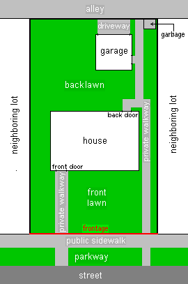
The part of the boundary of the lot next to a street or road is the frontage. Developers try to provide at least one side of frontage for every lot, so owners can have transport access to their lots. As the name implies, street frontage determines which side of the lot is the front, with the opposite side being the back. If the lot area is known, from the deed, then the frontage line can be calculated as depth by measuring the width (as area divided by width = depth). Sometimes minor, usually unnamed driveways called alleys, usually publicly owned, also provide access to the back of a lot. When alleys are present, garages are often located in back of a lot with access from the alley. Also when there are alleys, garbage collection may take place from the alley. Lots at the corners of a block have two sides of frontage and are called corner lots. Corner lots may have the advantage that a garage can be built with street access from the side, but have the disadvantage that there is more parkway lawn to mow and more pavement to shovel snow from. In areas with large blocks, homes are sometimes built in the center of the block. In this situation, the lot will usually include a long driveway to provide transport access. Because the shape is reminiscent of a flag (the home) on a flag pole (the driveway), these lots are called flag lots.

Development and use

[edit]
Vacant lot, with fencing

Local governments often pass zoning laws which control what buildings can be built on a lot and what they can be used for. For example, certain areas are zoned for residential buildings such as houses.[2] Other areas can be commercially, agriculturally, or industrially zoned. Sometimes zoning laws establish other restrictions, such as a minimum lot area and/or frontage length for building a house or other building, maximum building size, or minimum setbacks from a lot boundary for building a structure. This is in addition to building codes which must be met. Also, minimum lot sizes and separations must be met when wells and septic systems are used. In urban areas, sewers and water lines often provide service to households. There may also be restrictions based on covenants established by private parties such as the real estate developer. There may be easements for utilities to run water, sewage, electric power, or telephone lines through a lot.

A marker to show the divisions of individual lots within a subdivision.

Something which is meant to improve the value or usefulness of a lot can be called an appurtenance to the lot. Structures such as buildings, driveways, pavements, patios or other surfaces, wells, septic systems, signs, and similar improvements which are considered permanently attached to the land in the lot are considered to be real property, usually part of the lot but often parts of a building, such as condominiums, are owned separately. Such structures owned by the lot owner(s), as well as easements which help the lot owners or users, can be considered appurtenances to the lot. A lot without such structures can be called a vacant lot, urban prairie, spare ground, an empty lot, or an unimproved or undeveloped lot.

Many developers divide a large tract of land into lots as a subdivision. Certain areas of the land are dedicated (given to local government for permanent upkeep) as streets and sometimes alleys for transport and access to lots. Areas between the streets are divided up into lots to be sold to future owners. The layout of the lots is mapped on a plat diagram, which is recorded with the government, typically the county recorder's office. The blocks between streets and the individual lots in each block are given an identifier, usually a number or letter.

Land originally granted by the government was commonly done by documents called land patents. Lots of land can be sold/bought by the owners or conveyed in other ways. Such conveyances are made by documents called deeds which should be recorded by the government, typically the county recorder's office. Deeds specify the lot by including a description such as one determined by the "metes and bounds" or quadrant methods, or referring to a lot number and block number in a recorded plat diagram. Deeds often mention that appurtenances to the lot are included in order to convey any structures and other improvements also.

In front of many lots in urban areas, there are pavements, usually publicly owned. Beyond the pavement, there may sometimes be a strip of land called a road verge, and then the roadway, being the driveable part of the road.

Examples

[edit]

Queen Street in Toronto was referred to as Lot Street before 1837 as it was used by British surveyors to mark park lots of important land owners in York, Upper Canada.

See also

[edit]

References

[edit]
Revisions and contributorsEdit on WikipediaRead on Wikipedia
from Grokipedia
A land lot, also known as a plot or parcel, is a discrete tract of owned or intended for ownership by individuals, entities, or governments, serving as a basic unit for real estate transactions and development. These lots are legally defined by boundaries established through processes that confirm property lines, corners, and features to resolve disputes and enable precise subdivision. In practice, land lots underpin by dictating development potential, with characteristics like size, shape, and location influencing compliance, creation, and patterns such as residential building or infrastructure placement. Systems like lot-and-block further standardize identification within subdivisions, facilitating efficient property conveyance and management across jurisdictions.

Core Definition

A land lot, also known as a parcel or plot, is a legally distinct tract of land separated from adjoining properties by precisely defined boundaries, intended for , transfer, taxation, or development as a single unit. These boundaries are established through processes that measure distances, angles, and physical markers, resulting in a legal description recorded in public documents such as deeds or plats. For a land lot to be recognized as legally viable, it must conform to state and local regulations, including minimum size thresholds, classifications, and subdivision standards, ensuring it functions independently without reliance on adjacent parcels. Non-conforming lots may face restrictions on use or require variances, as jurisdictions prioritize orderly land division to prevent disputes and support infrastructure planning. Legal descriptions of land lots commonly utilize methods such as (tracing boundaries by directions and distances from landmarks), the rectangular (dividing land into grids of sections and aliquots), or lot-and-block systems (referencing subdivided plats). Each method provides verifiable coordinates or references to monuments, enabling accurate delineation and title assurance.

Property Rights and Ownership

Ownership of a land lot entails a bundle of legal rights, including possession, control, enjoyment, exclusion of others, and disposition through sale, lease, or inheritance. These rights extend to the surface, the above to a reasonable extent, and the subsurface minerals and resources, subject to regulatory limitations such as or environmental laws. The bundle framework originates from principles, emphasizing the owner's authority to utilize the parcel productively while bearing associated liabilities, such as maintenance and taxation. Fee simple absolute represents the most comprehensive form of , conferring perpetual, inheritable in the land lot without reversionary conditions to a grantor. Under this estate, the owner holds unrestricted to develop, subdivide, or encumber the , provided compliance with applicable statutes. Leasehold interests, by contrast, provide only a temporary estate for a defined term, such as 99 years, where the lessee gains possessory but the lessor retains and potential reversion upon term end. Other lesser estates, like life estates, limit to the duration of an individual's life, with remainder interests vesting afterward. Title to a land lot is evidenced by a , a written instrument executed by the grantor to convey , which must meet formalities like witnessing and delivery for validity. Deeds are recorded in public registries to provide of and encumbrances, preventing bona fide purchasers from later challenges. Jurisdictions employ either deed registration systems, which catalog transactions without state title assurance, or title registration systems like Torrens, implemented first in in 1858 and adopted variably elsewhere, issuing a guaranteed certificate of that simplifies transfers and insures against defects. Concurrent ownership forms include joint tenancy, featuring right of survivorship where a co-owner's automatically vests their share in survivors, and tenancy in common, allowing independent partition or devise by will. Property rights are not absolute; they yield to easements granting non-possessory access to others for utilities or rights-of-way, and to sovereign powers like for public use with compensation. These mechanisms balance individual ownership incentives with communal needs, fostering verifiable title security essential for land lot markets.

Historical Context

Early Concepts and Common Law

In medieval following the of 1066, land was conceptualized not as absolute private property but as held in tenure from , forming the basis of feudal obligations. The king claimed ultimate ownership (dominium) over all territory, granting parcels known as fiefs or honors to tenants-in-chief in exchange for military service, counsel, or other duties, while these tenants could sub-grant smaller portions to sub-tenants under similar tenurial conditions. This hierarchical system, solidified by the survey of 1086 which cataloged land holdings for taxation and feudal assessment, treated land lots—often manors or hides of roughly 120 acres—as functional units tied to rather than fixed geometric divisions, with rights derived from customary possession () rather than abstract title. Early divisions arose through , upon tenant death without heirs, or royal grants, but lacked standardized boundaries, relying instead on oral traditions, landmarks, and perambulations (ritual walks to affirm limits). Under developing from the , the concept of discrete land lots gained legal recognition through writs protecting possessory interests in specific parcels, emphasizing empirical delineation over feudal hierarchy. Henry II's , including the assize of disseisin (circa 1166), provided remedies for wrongful dispossession, requiring plaintiffs to prove of a defined lot, thus incentivizing written descriptions via —chains of calls referencing natural monuments (e.g., trees, streams), adjacent owners, and compass bearings—to establish verifiable claims. This method, rooted in pre-Conquest Anglo-Saxon charters and Roman-influenced practices, allowed for subdivision of manors into smaller lots for alienation, though transfers required (symbolic delivery) and were constrained by tenure rules prohibiting free alienation without lordly consent until the Statute (1290) curtailed . Disputes over lot boundaries, common in agrarian communities with open-field systems, were resolved in royal courts via juries of neighbors attesting to ancient customs, prioritizing long-continued possession over abstract surveys. By the late medieval period, evolved toward treating land lots as heritable estates in —potentially perpetual conditional ownership—detached from personal service, as seen in the growth of tenures for customary lots on manorial wastes. This shift, driven by economic pressures like and market-oriented farming, formalized lot integrity against encroachments, with escheators enforcing feudal incidents on transfers. However, the absence of centralized cadastral records perpetuated ambiguities, as boundaries often shifted via or agreement, reflecting a pragmatic realism grounded in observable use rather than theoretical equality. These principles influenced subsequent English and American , embedding the lot as a bounded, alienable unit within a framework of tenure-derived rights.

Modern Surveying Systems

Modern land surveying systems for delineating lots rely on electronic instruments and satellite technologies that provide centimeter-level precision, enabling efficient mapping of boundaries, , and legal parcels compared to manual methods prevalent before the 1980s. These systems integrate , computation, and storage, minimizing fieldwork time and human error while supporting digital records for cadastral purposes. Key advancements include the adoption of Global Navigation Satellite Systems (GNSS), total stations, Geographic Information Systems (GIS), and unmanned aerial vehicles (UAVs) equipped with or . Total stations, developed in the 1970s and widely adopted by the 1980s, combine an electronic for angle measurement with an electronic distance meter (EDM) for ranging, allowing simultaneous capture of horizontal/vertical angles and distances to compute 3D coordinates. In cadastral applications, they achieve accuracies of 1-5 mm for distances and 1-2 seconds for angles, facilitating precise boundary retracement and monumentation on lots up to several hectares. Robotic variants, operable by a single surveyor via , further enhance productivity in urban or obstructed terrains. GNSS technologies, particularly Real-Time Kinematic (RTK) GPS, transformed lot surveying starting in the early 1980s when the U.S. National Geodetic Survey (NGS) initiated GPS-based operations, with full operational status by 1993. RTK systems use carrier-phase measurements from base stations to deliver real-time positions accurate to 1-2 cm horizontally, ideal for establishing geodetic control points and tying lot boundaries to national datums like NAD83. Civilian accuracy improved dramatically after the U.S. discontinued Selective Availability in 2000, reducing positional errors from meters to sub-meter levels without differential corrections. In practice, GNSS enables rapid surveys of large or remote lots, often integrated with total stations for hybrid workflows. GIS platforms complement field instruments by digitizing survey data into layered spatial databases, incorporating lot boundaries with attributes like ownership, , and for and visualization. Adopted in land management since the , GIS facilitates overlay of GNSS-collected points with existing cadastral records, enabling detection of encroachments or discrepancies via spatial queries, with coordinate precisions tied to input data accuracies. Tools like process vector-based lot polygons, supporting scalable mapping from individual parcels to subdivisions. Emerging UAV systems, deployed for lot surveys since the , use or to generate dense point clouds for boundary verification over areas exceeding 100 hectares in hours rather than days. -equipped drones achieve vertical accuracies of 5-10 cm under canopy cover, useful for preliminary delineation but requiring ground control from GNSS or total stations for legal-grade precision, as UAV data alone may not suffice for disputes due to atmospheric and variables. Regulatory approvals, such as FAA Part 107 in the U.S. since 2016, have standardized their integration, though they augment rather than replace traditional methods for sub-centimeter boundary work.

Technical Aspects of Delineation

Surveying Methods

Surveying methods for land lots primarily focus on boundary surveys, which combine legal record with precise field measurements to identify and mark property corners and lines in accordance with deeds and statutes. These methods ensure accurate delineation to prevent disputes and support development, relying on techniques that measure distances, angles, and positions relative to established control points. Traditional surveying techniques include traverse methods, where surveyors sequentially measure angles and distances from known benchmarks to trace parcel boundaries, often using chains or tapes for linear measurements and theodolites for angular observations. Traverse surveys can be closed—returning to the starting point for error checking—or open, with potential accuracies up to 1 part in 1,000,000 when using precise instruments like geodimeters. Triangulation, involving angle measurements across a network of triangles from a measured baseline, has historically supported larger-scale control for lot subdivisions, achieving first-order accuracies of 1:100,000 or better. Astronomic positioning supplements these by orienting traverses via stellar observations, such as measuring the altitude of to determine . Trilateration, based solely on electronic distance measurements over long baselines using systems like SHORAN, connects remote areas but is less common for individual lots. Modern methods have largely supplanted manual techniques with electronic total stations, which combine theodolites for angle measurement with electronic distance measurement (EDM) for rapid, high-precision , typically yielding angular accuracies of 1 arcsecond and distance errors of 1-2 mm plus 1-2 ppm over measured lines. These instruments facilitate efficient traverse work for boundary retracement, where existing monuments are located and verified against record bearings and distances. Global Navigation Satellite Systems (GNSS), particularly Real-Time Kinematic (RTK) GPS, provide direct three-dimensional positioning with horizontal accuracies of 1-2 cm by resolving carrier-phase ambiguities and applying differential corrections from base stations, enabling surveys over obstructed without line-of-sight requirements. In practice, boundary surveys often employ closed traverses to minimize systematic errors, with state standards requiring angular closures better than 1:5,000 to 1:20,000 and linear misclosures not exceeding 1:3,000 to 1:10,000 of traverse length, adjusted via least-squares methods for final accuracy. Integration of GNSS with total stations allows hybrid approaches, using satellite data for initial control and optical instruments for dense boundary detailing, enhancing overall reliability in lot delineation.

Boundary Determination and Disputes

Boundary determination for land lots relies on a hierarchy of evidence derived from original deeds, surveys, and physical markers to establish precise legal limits. Licensed surveyors conduct boundary surveys by first researching public records, including deeds, plats, and historical surveys, to identify the parcel's description, then performing field measurements to locate monuments such as iron pins, stone markers, or natural features like streams that control over abstract measurements. In common law jurisdictions, this follows the principle that physical monuments prevail over courses and distances in metes-and-bounds descriptions, ensuring boundaries reflect intent from the original grant rather than later recalculations. Disputes commonly arise from ambiguities in outdated or erroneous surveys, encroachments such as fences or structures crossing lines, changes in natural boundaries like shifting watercourses, or reliance on visible features like hedges that do not align with legal descriptions. For instance, inaccurate historical surveys from the , often conducted with rudimentary tools like chains and compasses prone to cumulative errors, contribute to modern conflicts, particularly in rural areas where vegetation obscures markers. Vague deed language, such as "along the old road" without specifying its path, exacerbates issues when physical evidence is absent or contested. Resolution typically begins with commissioning an independent survey by a licensed professional to retrace original boundaries using the evidence hierarchy, followed by or to avoid litigation. If unresolved, courts apply doctrines like —requiring open, notorious, continuous, and hostile use for a statutory period, often 10 to 20 years depending on —or boundary by , where long-term mutual recognition of a line establishes it legally. Judicial outcomes prioritize from surveys over unverified claims, though equitable considerations like relative hardship may influence decisions in encroachment cases. or quiet title actions provide alternatives, with costs averaging $1,000 to $5,000 for surveys and potentially higher for trials, underscoring the value of preventive reviews.

Utilization and Development

Primary Uses

Land lots serve as foundational units for and economic activity, with primary uses determined by factors such as , regulations, , and proximity to . The most common categories include residential development, commercial operations, industrial facilities, agricultural production, and recreational or institutional purposes. These uses reflect the parcel's potential for generating value through habitation, , or resource extraction, often constrained by local ordinances that allocate land to prevent incompatible activities. Residential use predominates in suburban and urban fringe areas, where lots are subdivided for single-family homes, multi-family dwellings like apartments or townhouses, and accessory structures such as garages. In the United States, residential parcels account for a significant portion of developed , enabling and community formation while supporting ancillary services like schools and utilities. This use prioritizes livability, with lot sizes typically ranging from 0.1 to several acres, influenced by requirements that balance with efficient allocation. Commercial use involves retail outlets, buildings, and service-oriented structures on lots in high-traffic zones, fostering economic exchange and . Such parcels often feature higher along roads for visibility and access, with examples including shopping centers and restaurants that drive local commerce. for commercial lots emphasizes and , as these uses generate through leasing but can impose externalities like and congestion if not buffered from residential areas. Industrial use designates lots for , warehousing, and heavy operations requiring space for machinery, storage, and , typically located near transportation corridors to minimize disruption to populated zones. These parcels accommodate activities like assembly lines or distribution centers, with lot configurations optimized for loading docks and rail access; however, they necessitate environmental safeguards due to potential from emissions or waste. In practice, industrial isolates such uses to protect values elsewhere. Agricultural use applies to larger rural lots devoted to crop cultivation, livestock grazing, or , leveraging and for food production and resource harvesting. In the U.S., cropland and constitute over 900 million acres of private land, underscoring agriculture's role in sustaining supply chains, though smaller lots may support hobby farms or orchards under protective designations like Chapter 61A in . This use preserves open space but faces pressures from , with viability tied to , market proximity, and subsidies. Other primary applications include recreational lots for parks, sports fields, or conservation, which provide public amenities and benefits without intensive development, and transportation corridors for roads, railways, or utilities that facilitate connectivity across parcels. Vacant lots, often held for speculative appreciation, represent an interim use allowing flexibility for future intensification. These categories evolve with demographic shifts and policy, as evidenced by mixed-use trends integrating residential and commercial elements to optimize urban efficiency.

Development Procedures

The development of a land lot generally commences with a feasibility assessment, encompassing verification, environmental impact evaluations, and to determine viability. Developers must confirm compliance with local ordinances, which dictate permissible uses such as residential, commercial, or industrial, often requiring rezoning applications if the current designation is incompatible. For instance, in , this phase includes reviewing comprehensive plans and submitting rezoning requests to align the lot with intended development. Environmental , mandated under frameworks like the in the U.S., involves site surveys for wetlands, endangered species, or contamination, potentially necessitating permits from agencies such as the U.S. Army Corps of Engineers. Subsequent procedures focus on and subdivision if the lot requires division into smaller parcels. A preliminary or sketch is prepared by licensed surveyors and engineers, detailing proposed boundaries, roadways, and utilities, followed by submission for public review and approval. In , this includes sketch plan reviews, final site approvals, and performance bonds to ensure completion. Subdivision approvals, governed by state laws like California's Subdivision Map Act, require final tract maps for five or more parcels or parcel maps for fewer, ensuring adherence to standards and provisions. designs for grading, management, and utility extensions are integral, with rough grading often preceding installation of wet utilities such as sewers and water lines. Permitting and construction phases enforce through building permits, measures, and inspections. Site preparation involves clearing, excavation, and installation of dry utilities like and gas, culminating in final recordation and release of bonds upon verified completion. In , the process integrates zoning, subdivision platting, site plans, and final permitting, with timelines varying from months to years based on project scale and local scrutiny. Post-construction, certificates of occupancy are issued, enabling lot sales or building commencement, though ongoing compliance with covenants or rules may apply in subdivided developments. These procedures, while standardized in principle, exhibit jurisdictional variances, with urban areas imposing stricter reviews than rural ones to mitigate strain.

Regulatory Frameworks

Zoning ordinances form the cornerstone of land lot regulation in the United States, dividing jurisdictions into districts that designate permissible uses such as single-family residential, multi-family residential, commercial, or industrial, while specifying standards for minimum lot sizes, maximum building coverage, setbacks from property lines, and height restrictions. These rules, upheld by the U.S. in Village of v. Ambler Realty Co. (1926), aim to separate incompatible land uses and control , with local municipalities enacting and enforcing them under state enabling acts. Variations exist by locality; for instance, many communities mandate minimum lot areas of 20,000 to 40,000 square feet in suburban zones to preserve open space and capacity. Subdivision regulations complement zoning by governing the platting and division of larger parcels into individual lots, requiring developers to submit plans for approval that address lot configuration, block layouts, street widths (typically 50-60 feet for local roads), utility easements, and drainage to prevent flooding and ensure access. In practice, these rules mandate infrastructure improvements like curb-and-gutter systems and sidewalks before final recording, with counties such as Shasta, , specifying standards under Title 15 of their codes for and fiscal viability of new developments. Non-compliance can result in denied permits or legal challenges, as subdivisions must align with comprehensive plans projecting and service demands. Building codes and permitting processes overlay these frameworks, mandating compliance with standards from the International Building Code (adopted variably by states) for structural integrity, , and on lots prior to construction commencement. Development permits, often requiring reviews, environmental assessments under the for federal involvements, or local impact fees, ensure lots meet and subdivision criteria while mitigating effects on traffic, , and ecosystems. Variances or conditional uses may be granted through zoning boards for deviations, but only upon demonstrating hardship without undermining public welfare, as seen in appeals processes across U.S. jurisdictions. Federal and state overlays, such as wetland protections under the Clean Water Act or agricultural preservation easements, further constrain lot usability in sensitive areas, prohibiting development on designated floodplains or habitats without mitigation. These layered regulations, while promoting orderly growth, vary internationally; in contrast to U.S. local dominance, countries like emphasize provincial policies such as Ontario's Provincial Policy Statement for broader land use direction. Jurisdictional enforcement relies on planning departments, with appeals to boards or courts ensuring .

Economic Dimensions

Valuation Techniques

The primary method for valuing land lots is the sales comparison approach, which estimates value by analyzing recent sales of comparable vacant parcels, adjusting for differences in , , , , access, and utilities. Appraisers select at least three similar sales within the same market area, typically within the past six to twelve months, and apply quantitative adjustments—such as $X per for size variances or percentage premiums for superior utility access—to derive an indicated value per unit of measure, often price per acre or per front foot. This market-derived technique assumes rational buyers and sellers, reflecting actual transaction data over hypothetical models, though challenges arise in sparse markets where adjustments rely on paired sales analysis or professional judgment. For income-producing land lots, such as those used for , timber, or leasing, the income approach capitalizes projected net operating at a market-derived rate to estimate . is derived from rental rates or crop yields minus expenses, divided by a reflecting risk and return expectations—e.g., 4-6% for stable farmland as of 2023 data. This method is less applicable to non-revenue-generating urban lots but extends via the land residual technique for development sites: appraisers forecast the value of a completed (using or approaches), subtract estimated costs, entrepreneurial profit (typically 10-20%), and financing charges, with the remainder indicating land value. Residual valuations require verifiable cost data from sources like RSMeans and market profit benchmarks to avoid overestimation tied to speculative development assumptions. When direct comparables are unavailable, the extraction or method under the approach isolates value by deducting depreciated from an improved property's total price. is calculated via age-life methods or market extraction, using from paired improved ; for instance, if an improved lot sells for $500,000 with $300,000 in depreciated building value, is extracted at $200,000. The allocation method supplements this by apportioning total prices from bulk based on -to- ratios observed in the market, such as 20-40% share in suburban developments. These -oriented techniques serve as checks rather than primaries, as they indirectly derive value and may understate highest-and-best-use potential without forward-looking adjustments. Appraisers reconcile approaches weighted by reliability, prioritizing comparison for its empirical basis in arm's-length transactions.

Taxation and Fiscal Impacts

Land lots are subject to property taxes levied by local governments, typically calculated as an ad valorem rate applied to the assessed value of the land itself, excluding improvements on vacant parcels. Assessments often reflect the land's "," such as potential residential or commercial development, rather than its current undeveloped state, to capture economic potential and prevent undervaluation. In jurisdictions employing land value taxation (LVT), vacant lots face taxation equivalent to adjacent developed properties, emphasizing the unimprovable nature of land value, whereas conventional systems tax only the existing land value, which is generally lower and may incentivize speculative holding over utilization. Property taxes constitute a primary revenue source for U.S. local governments, accounting for approximately 75% of local tax collections and 30% of overall general , totaling $609 billion in 2021. These funds predominantly support including public education, maintenance, and municipal operations, with land lot taxes contributing even from undeveloped parcels that impose minimal service demands, thereby yielding a net fiscal surplus in some analyses. Effective rates vary widely by state, averaging around 1% of assessed value nationally, though median annual payments reached $1,889 per in 2023, with higher burdens in states like (2.23%) and lower in (0.27%). Fiscal impacts extend to land use decisions, where conventional property taxes—applied to both land and improvements—can distort development by increasing costs on built structures, potentially reducing investment in housing or commercial projects and exacerbating shortages. Economists generally view property taxes as less economically harmful than income or sales taxes due to land's inelastic supply, minimizing deadweight loss, though taxing improvements rather than pure land value may still discourage densification or upgrades. Proposals for split-rate taxation, which impose higher rates on land than buildings, aim to mitigate these effects by promoting efficient use and reducing urban sprawl, as evidenced in limited implementations like Pennsylvania cities where development activity increased post-reform. Overall, while providing stable revenue, property taxation on land lots influences holding costs, with empirical studies indicating negative correlations between high rates and new construction square footage or lot density.

Market Influences

The market for land lots operates under fundamental supply constraints, as land is finite and subdivision is limited by topography, environmental regulations, and zoning ordinances that cap density and permissible uses. Demand, conversely, stems from demographic pressures such as population influx and household formation, alongside economic drivers like industrial expansion, which elevate prices in high-growth regions; for example, U.S. agricultural land values rose 5% annually from 2020 to 2023 due to sustained demand amid constrained supply. When demand outstrips supply—as seen in urban fringe areas with lot shortages—prices escalate, with builders facing heightened competition that inflates acquisition costs by up to 20-30% in bottleneck markets. Macroeconomic factors profoundly modulate these dynamics, including interest rates that dictate borrowing costs for developers and speculators; elevated rates, as persisted above 5% in 2023-2024, suppress lot demand by increasing capitalization rates and reducing net present values of future developments. levels and GDP growth further amplify effects, with robust job markets—such as U.S. dipping below 4% in late 2023—boosting residential lot turnover, while inflationary pressures erode and favor land as an . Economic cycles exhibit cyclicality, wherein expansions correlate with 10-15% annual land value gains in expanding metros, per historical USDA data on farmland, whereas downturns, like the 2008-2009 contraction, precipitated 20-40% declines in speculative lot markets. Government interventions and infrastructural developments introduce exogenous influences, with reforms or utility extensions unlocking latent value; a single access improvement can double adjacent lot prices within 2-3 years by enhancing . Taxation policies, including levies and capital gains treatments, also sway sentiment, as higher assessments deter holding vacant lots, prompting that flood local supply. Recent U.S. lot supply metrics reflect partial relief, with the New Home Lot Supply Index rising 5.4% from Q3 to Q4 2024, attributable to eased permitting in select states, though persistent regulatory hurdles maintain upward price trajectories in supply-constricted zones.

Controversies

Eminent Domain and Takings

Eminent domain empowers governments to seize private land lots for public use, provided just compensation is paid, as enshrined in the Fifth Amendment to the U.S. Constitution, which states that private property shall not "be taken for public use, without just compensation." This authority has historically facilitated essential projects, such as highways and utilities, by allowing compulsory acquisition when owners refuse voluntary sales. However, physical takings of land lots remain contentious due to disputes over the definition of "public use" and the adequacy of compensation, often pitting individual property rights against asserted communal benefits. A pivotal controversy emerged from the 2005 Supreme Court decision in Kelo v. City of New London, where a 5-4 majority ruled that transferring seized land lots to private developers for economic redevelopment qualified as a permissible "public use" if it promised broader economic gains, such as job creation. In this case, the city of , condemned non-blighted residential lots, including Susette Kelo's home, to facilitate a Inc.-linked office and hotel complex projected to generate $1.1 million in annual property taxes. The dissent, led by Justice O'Connor, argued this effectively authorized takings for private benefit under the guise of public purpose, inverting the Takings Clause's protections. The development ultimately collapsed after Pfizer relocated in 2009, leaving the site as an empty lot and underscoring risks of failed projects displacing owners without realized benefits. The Kelo ruling provoked significant backlash, with critics from property rights advocates highlighting its expansion of government discretion, enabling takings that favor politically connected developers over small landowners. In response, at least 45 states enacted reforms by 2010 to restrict for , often requiring stricter designations or prohibiting transfers to private entities absent genuine necessity. Despite these measures, abuses persist; for instance, in cases like the 2006 taking of properties in , for a private mall expansion, where owners alleged undervaluation and favoritism toward commercial interests. Compensation disputes compound issues, as governments typically offer appraised , which owners contest as insufficient to cover relocation costs or lost sentimental value, leading to protracted litigation in up to 75% of cases. Empirical patterns reveal disproportionate impacts on lower-income and minority communities, where land lots in zones are frequently targeted, raising equity concerns without adequate safeguards against arbitrary valuations. Federal takings, tracked by the Department of Justice, have historically numbered in the thousands annually for projects like national parks, though comprehensive recent state-level data remains fragmented due to varying reporting. Ongoing debates center on reconciling eminent domain's utility for public goods—such as the 1956 , which acquired over 1 million parcels—with causal risks of overreach, where speculative "public benefits" erode foundational property rights essential for economic liberty.

Over-Regulation and Stagnation

Excessive regulations, encompassing restrictions, protracted permitting timelines, impact fees, and environmental compliance requirements, impede the timely and cost-effective development of lots, fostering stagnation in and commercial . Empirical research demonstrates that these barriers reduce housing supply elasticity, with metropolitan areas exhibiting high regulatory stringency showing supply responses to demand shocks that are 50-70% lower than in lightly regulated counterparts. For example, in U.S. cities classified under strict regulatory regimes via indices like the Wharton Residential Regulatory Index, median prices exceed costs by factors of 3 to 5 times, far beyond what raw values or material inputs would dictate. This supply constriction manifests as chronic underbuilding: from 2012 to 2022, U.S. housing starts averaged 1.1 million units annually against a demographic need exceeding 1.5 million, with regulatory delays adding 12-24 months to projects in high-constraint states like and New York. laws mandating low-density single-family use on up to 75% of urban land in many jurisdictions exemplify this, artificially limiting multi-unit development and exacerbating shortages that drive vacancy rates below 5% in constrained markets while idling peripheral lots. A attributes at least 30% of post-2000 housing price escalation in major metros to such policies, independent of demand factors like . The resulting stagnation extends to productivity: U.S. construction sector output per worker has flatlined since the 1970s, with land regulations forcing bespoke, low-volume builds rather than modular or high-density efficiencies seen in less-regulated economies like Japan, where looser zoning sustains supply growth at 1-2% annually. Economists estimate these distortions impose a GDP drag of 1.5-2.5% of national output, as restricted land access hampers labor mobility and firm location decisions, confining workers to suboptimal regions. While proponents argue regulations mitigate externalities like congestion or sprawl, cross-jurisdictional evidence reveals that marginal increases beyond baseline protections yield diminishing benefits while amplifying costs, particularly for lower-income households facing effective barriers to entry.

Property Rights vs. Public Interventions

Private property rights in land lots traditionally encompass the owner's authority to possess, use, improve, and alienate the parcel, grounded in principles that incentivize stewardship and efficient allocation through market mechanisms. Public interventions, including ordinances, environmental mandates, and rules, impose limitations to address externalities such as , , or , often prioritizing collective interests over individual autonomy. These measures can erode the economic when they preclude highest-and-best uses, prompting debates over compensation and the boundaries of state power under doctrines like the U.S. Fifth Amendment's Takings Clause. Regulatory takings occur when government actions substantially impair property value without physical invasion or formal acquisition, as clarified in key U.S. precedents. In Lucas v. Coastal Council (1992), a state prohibiting permanent structures on beachfront lots to combat denied the owner all economically beneficial use, equating to a categorical taking unless prohibited by antecedent principles; the Court mandated compensation for the $975,000 loss in value. Conversely, Penn Central Transportation Co. v. (1978) upheld restrictions barring development above under a landmarks , applying a fact-specific balancing test weighing the regulation's economic impact (denied worth millions), interference with investment expectations, and governmental nature as non-possessory. These rulings illustrate how interventions may transfer value from owners to the —such as through —without always triggering just compensation, fostering incentives for regulatory evasion or underutilization. Empirical analyses reveal that pervasive land-use controls, including minimum lot sizes and use prohibitions, diminish development potential and exacerbate , elevating costs by 20-50% in regulated U.S. markets through supply constraints rather than alone. Studies across metropolitan areas confirm that stringent correlates with reduced land values for constrained parcels, as owners face barriers to subdivision or intensification, while benefiting incumbents via ; for instance, intra-jurisdictional variation in regulations shows direct links to lower assessed values in restricted zones. Cross-national data further indicate that secure rights enhance land-use efficiency by encouraging investment, with weaker protections under public-heavy regimes leading to misallocation and stagnation, as governments favor short-term political objectives over long-term . Critics of expansive interventions argue they impose uncompensated burdens akin to partial expropriations, distorting markets and violating causal incentives for in stewardship, though proponents cite mitigated harms like sprawl reduction; however, evidence from deregulatory experiments, such as upzoning in select cities, demonstrates increased supply and stabilized prices without commensurate rises in negative externalities. This tension underscores ongoing reforms, including compensation mandates or streamlined permitting, to reconcile rights with public needs while averting regulatory excess that hampers economic vitality.

International Variations

Ownership Systems

Private ownership systems, prevalent in market-oriented economies such as the , , and , typically feature freehold or tenure, granting individuals perpetual rights to possess, use, develop, and alienate land lots without time limitations, subject to regulatory constraints like . Civil law traditions, exemplified by Germany, conceptualize land lots as "Grundstücke," legally partitioned units of the earth's surface registered in the cadastre with unique identifiers, serving as the primary units for ownership, transactions, and registration under the Bürgerliches Gesetzbuch (German Civil Code). These parcels encompass the land and firmly attached structures, enabling precise delineation for conveyance, taxation, and development, with registration emphasizing statutory formality over customary practices. This model, derived from English , facilitates investment and market transactions, with data indicating that secure freehold titles correlate with higher and urban development rates in regions adopting them post-colonialism. In contrast, leasehold systems dominate in densely urbanized areas of countries like the , where residential lots often carry 99- or 125-year leases from freeholders or , after which reversion occurs unless renewed, limiting long-term planning and value appreciation for lessees. Communal and customary tenure systems persist in much of , , and indigenous territories worldwide, where land lots are collectively managed by groups, tribes, or villages rather than individuals, emphasizing use rights for members over exclusive ownership. In nations like and , these informal arrangements cover 50-90% of rural land, providing social stability but often insecure against state reallocations or commercial grabs, as evidenced by World Bank analyses showing reduced in untitled communal plots due to dispute risks. Formal recognition efforts, such as group titling in since 2005, have aimed to enhance security while preserving communal governance, though implementation gaps persist. State-controlled systems, characteristic of socialist or transitional economies like and , vest ultimate of lots in the government or collectives, allocating usage rights via certificates valid for fixed durations—70 years for urban residential, 40-50 for commercial or agricultural uses. In , this framework, codified in the 1988 Land Administration Law and amended in 2019, prohibits private sales but permits transferable use rights, enabling rapid ; however, expiring leases have sparked over 100,000 compensation disputes annually as of 2020, underscoring tensions between state control and user expectations. Similar usufruct-like arrangements in former Soviet states, such as Russia's 49-year agricultural leases, prioritize public planning over individual perpetuity, correlating with lower private investment per World Bank evaluations. Hybrid models, blending elements like public leaseholds in (99-year state grants covering 90% of ), demonstrate how state oversight can coexist with market dynamics, yielding high-density efficiency but dependency on renewal policies.

Regional Case Studies

In the United States, land lots are systematically subdivided using the (PLSS), established in the late 18th century to divide lands into standardized rectangular parcels of 640-acre sections, further aliquot parts for sale and ownership transfer. This grid-based approach, applied across much of the western U.S., enables precise legal descriptions via township, range, and section identifiers, minimizing boundary disputes and supporting private fee-simple ownership. For instance, in , PLSS governs rural land parcels, with used supplementally for irregular urban lots, ensuring cadastral accuracy for taxation and development. In northern , traditional pastoralist communal has undergone transformation through community conservancies, where group ranches—initially established in the 1970s for Maasai herders—evolved into formalized entities granting collective title over large tracts, subdivided implicitly for grazing and . By 2023, over 20 conservancies covered 10% of Kenya's , blending customary with statutory to lease portions for revenue, though this has intensified internal disputes over lot allocations amid and privatization pressures. Empirical from conservancy records show revenue increases from $0.5 million in 2000 to $10 million annually by 2020, but causal analyses attribute tenure insecurity to unequal benefit distribution favoring elites. Turkey's urban land lot subdivision, particularly in Istanbul's , relies on minor subdivisions for small-scale divisions, land readjustment schemes pooling irregular parcels for replatting, and expropriations for , with municipalities approving plans under the 1985 Land Readjustment Law. Case studies from 1980s-2000s expansions document over 1,000 km² of peri-urban land converted via readjustment, increasing lot densities from 10-20 per to 50+, but often resulting in fragmented and speculation-driven price hikes of 200-300% post-subdivision. These practices prioritize state-led densification over market-driven platting, contrasting private U.S. models, though official statistics underreport informal encroachments comprising 20-30% of new lots. In , land lot management accommodates hybrid tenure systems, integrating formal titles with indigenous resguardos and informal posadas, as tested in pilot administrations across regions like Antioquia and Amazonas since 2010. A 2021 study of experimental zones revealed that fit-for-purpose mapping reduced tenure disputes by 40% in mixed-rights areas covering 5 million hectares, using participatory delineation to subdivide communal lots into individual parcels while preserving collective oversight. This approach addresses historical inequities from 19th-century enclosures, with cadastral data showing 70% of rural lots under dual formal-informal status, enabling credit access but vulnerable to without robust verification. Norway's subdivision of rural and peri-urban land lots emphasizes regulatory oversight, with processes under the 2008 Planning and Building Act requiring municipal approval for divisions below 2-5 hectares, benchmarked against Denmark's faster digital permitting (averaging 6 months vs. Norway's 12) and Sweden's emphasis on environmental impact assessments. A 2011 comparative analysis of 50+ cases found Norwegian costs at €5,000-10,000 per lot due to mandates, yielding higher boundary precision (error <1m) than Danish counterparts (2-3m), though slower timelines stagnate development in high-demand areas like suburbs where lot prices rose 15% annually from 2010-2020.

References

Add your contribution
Related Hubs
User Avatar
No comments yet.