Community hub
Manacor
View on Wikipedia
Manacor (Balearic Catalan: [mənəˈkɔ]) is a town and municipality on the island of Mallorca, part of the Spanish autonomous community of the Balearic Islands. It is the second-largest town in Mallorca, after the capital of Palma. The municipality features tourist attractions such as Porto Cristo, site of the famous Caves of Drach, and Cales de Mallorca. Manacor has one of the busiest street markets on the island, held every Monday morning. Manacor is famous for high-quality wood furniture manufacturing and artificial pearls.[2]
Key Information

.svg)
.svg)


History
[edit]The first indications of human occupation in the area of Manacor go back to 2000-1200 BC. Of this period are the artificial coves as burial places (cova de s'Homonet at Son Ribot, Mitjà de ses Beies at Sa Sínia Nova, etc.), and a type of construction similar to the naveta, either isolated or grouped in villages, which were used as living spaces (sa Marineta, s'Hospitalet Vell, etc.)
Of the megalithic Talaiot culture, the most outstanding constructions are s'Hospitalet Vell, es Boc, Bellver, as well as the constructions of Bendrís, Son Sureda and Sa Gruta.

The origin of the town of Manacor goes back to the times before the Islamic dominance. In Porto Cristo, the submarine discoveries of objects show that it was a Roman port. The remains of the basilicas of sa Carrotja and son Peretó prove the existence of well-established Christian communities.
After the invasion launched by James I of Aragon, Nuño Sánchez received from him the land of Manacor. In 1300, James II granted Manacor a statute of municipality. The Torre del Palau and the fortification of some rural houses like the Torre de ses Puntes and the Torre dels Enagistes have been preserved from the beginnings of town planning at Manacor.
Although the etymology of the word Manacor seems to be Amazighe, the coat of arms (hand holding a heart) is originated by the phonetic approximation in the Catalan language, like other coats of arms around the island.
A native of Manacor, Simó Tort, was a character in medieval social conflicts.
Saint Vincent Ferrer came to Manacor in 1414. In 1576 the convent dedicated to the saint was founded, and after this the construction of the baroque church began. At the beginning of the following century the construction of the cloister began.
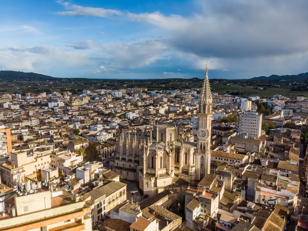
In 1879 the railroad line from Inca to Manacor was opened. About 1890 the construction of the new parish church Nostra Senyora dels Dolors began, located on the same place as the former churches. The most ancient of them had been documented in 1232 and had possibly been built upon an Arab mosque. The bell tower of the present church, an emblem of the town, measures 75 metres. In 1897 the first factory of artificial pearls, the famous Majorica, was founded. So Manacor became the business and industrial centre of Llevant. In 1912 Manacor received the title of town.
In 1936, during the Spanish Civil War, there was an attempted landing of republican forces in the shores of Porto Cristo that was repelled by the fascist forces. The mayor of Manacor, Antoni Amer Llodrà "Garanya", was assassinated by the fascists.
Geography
[edit]The relief is not very pronounced. It takes in three areas: the flat region of the Pla, where the town of Manacor stands; the Serra de Llevant, characterised by its soft relief; and the Marina, which is formed by white gritty stone and inclines down to the sea. These limestone karsts have favoured the appearance of caves. The most outstanding for their beauty are the Dragon Caves and the Fishhook Caves. Near the coast, there is one of the longest underwater caves known in Europe : the Gleda-Camp des Pou system. It has more than 13 km in length.


A wide range of coves embellish the coast of Manacor: S'illot, Cala Morlanda, Cala Petita, Porto Cristo, Cala Anguila, Cala Mendia, s'Estany d'en Mas, Cala Falcó, Cala Varques, Cala Sequer, Cala Magraner, Cala Pilota, Cala Virgili, Cala Bota, Cala Antena, Cala Domingos and Cala Murada.

The climate is Mediterranean, with typically mild winters and hot summers. During the months of July and August, the weather is hot and sunny, boasting around 11 hours of sun daily. During the winter, the weather can get chilly, but mild.[3] The average annual temperature is between 16 and 17 °C.
The forest area represents little more than 20% of the whole area. Pine forest is found in the mountainous areas but there are hardly any survivals of the indigenous holm-oak woodlands.
The cultivated land represents 74% of the area. The agricultural landscape is characterized by almond trees, cereals, fig trees, carob trees and vineyard. The cultivation of vegetables is focused on melon, pepper and lettuce.
The town of Manacor is crossed by the Sa Cabana stream. This stream flows into the Na Borges stream, the most important of the municipality.
Demographics
[edit]
| Municipality | Population |
|---|---|
| 16th century | 5,000 approx. |
| 18th century | 7,000 approx. |
| Beginning of 20th century | 13,000 approx. |
| Centers | Population 2005 |
|---|---|
| Manacor | 25,324 |
| Porto Cristo | 6,385 |
| S'Illot-Cala Morlanda | 1,576 |
| Son Macià | 839 |
| Cales de Mallorca | 725 |
| Cala Murada | 624 |
| Cala Anguila-Cala Mendia | 296 |
| S'Estany den Mas | 139 |
| Total | 35,908 |
Economy
[edit]Until the 19th century the economy of Manacor was based on agriculture (cereals and vineyard) and livestock (sheep), although the textile and food sectors as well as pottery were important too. Although there are no longer the large estates that there were at that time, there are some that maintain their antique splendor, such as Santa Cirga and Es Fangar (the largest).
The 19th century marked the beginning of the transformation of the town. The industrial activities dedicated to the processing of agricultural product increased; windmills and a liquor distillery appeared. From the second half of the century on the production of furniture became one of the basic industries of Manacor. Pottery and the production of liquors and wines also continued.
The factory of artificial pearls was very important during the 20th century.
From the 1960s, tourism was added to the development of the economic activity of the municipality.
Construction is an important sector, as well as commerce.
Culture
[edit]Sant Antoni
[edit]The most popular celebration in Manacor. The ceremony begins with the exit of a group of disguised men of Saint Anthony, the greater Demon and several smaller demons, on the eve of the 17 of January. They cross the streets performing a dance that represents the temptations to which the saint was submitted. At night bonfires are ignited. The group visit the several bonfires of the municipality. People sing and dance, and eat "llangonisses" and "botifarrons" (typical pork products of the island).
On the following day are celebrated the "Beneïdes", a parade of floats and animals of all types. They are blessed because the saint is the patron of the animals.
Fairs
[edit]The most important fairs are the Fires i Festes de Primavera. They are celebrated from the end of May to the beginning of June. During these days, there are many activities and exhibitions. The celebrations close with a parade of floats.
Other fairs : Fair of Saint James, patron of Manacor, the 25 July, and the September Fair.
Theatre
[edit]Manacor has an important theatre season, the Fira de Teatre de Manacor, usually in September/October.
Moratons
[edit]This is a ritual dance of uncertain origin. It seems that it was composed around the year 1855 for religious reasons, but it is possible that its origin goes back to 16th century. The clothes of the Moretons looked like those of Barbary pirates. When they dance, they hit wood pieces located in the hands, knees and abdomen.

Els Moretons go out in May, by the Sant Domingo celebrations.
Cossiers
[edit]There are documents about this ritual dance from 18th century. The cossiers are a group of men who dance around a woman known as "The Lady". They wear hats and coloured clothes.
Nowadays, they open the Fires i Festes de Primavera.
Vimer
[edit]This has been a legend for more than 100 years. The vimer (Salix viminalis) is a willow located in S'Hort des Correu, a country house in the outskirts of the town of Manacor. The legend says that the tree can heal children with hernia. For this, they are passed through the branches of the tree, when the sun rises on the Saint John's Day, the 24th of June.
Industry
An industry for which Manacor is famous, and indeed Mallorca in general, is olive wood.[4] There are factories in Manacor that allow visits. Manacor is also known for its artificial pearl factories.
Gastronomy
[edit]Typical products are Suspiros de Manacor, also known as Sospiros, sweet dry cookies often eaten with coffee or tea,[5] and the Pastís de Pobre (Poorman Cake).
Sports
[edit]In addition to the main sports - football, basketball and volleyball - Manacor has horse racing fans and there are chariot races at the hippodrome. Manacor is also the birthplace and home town of former Spanish football international player Albert Riera and tennis legend Rafael Nadal.
Natives of Manacor
[edit]References
[edit]- ^ National Statistics Institute (13 December 2024). "Municipal Register of Spain of 2024".
- ^ "Manacor". www.abc-mallorca.com. Retrieved 28 September 2023.
- ^ "Holiday guide for the town of Manacor, Mallorca, Balearic Islands". Spain-Holiday.com. Retrieved 12 October 2022.
- ^ "Holiday guide for the town of Manacor, Mallorca, Balearic Islands". Spain-Holiday.com. Retrieved 12 October 2022.
- ^ "Suspiros de Manacor". Recetas Mallorquinas (in European Spanish). Retrieved 12 October 2022.
External links
[edit]| International | |
|---|---|
| National | |
| Geographic | |
| Other | |
Manacor
View on GrokipediaHistory
Prehistoric and Ancient Settlements
The earliest evidence of human settlement in the Manacor region dates to the Bronze Age, with archaeological findings at sites such as s'Hospitalet Vell indicating occupation from approximately 2000 BC through the Iron Age. This settlement, located in the southern part of Manacor's municipality near the coast toward Calas de Mallorca, features naviform structures—elongated, boat-shaped dwellings typical of the Naviforme culture—and later Talayotic elements, reflecting an agrarian society adapted to the island's limestone terrain for defense and resource management. Talayots, megalithic stone towers built without mortar, served as communal or defensive structures, with examples at s'Hospitalet Vell demonstrating construction techniques using local stone blocks, often exceeding 10 meters in height and incorporating central chambers.[5][6] The Talayotic culture, dominant from around 1300 BC to the 2nd century BC, left additional traces in Manacor, including settlements like those at es Boc, Bellver, and Bendrís, characterized by circular towers and associated dwellings that supported small-scale agriculture and pastoralism. These structures underscore a continuity of prehistoric habitation, with artifacts such as pottery and tools evidencing trade contacts and technological persistence amid environmental constraints like arid soils and seasonal water scarcity. Excavations reveal no evidence of large-scale urbanization, aligning with island-wide patterns of dispersed rural communities rather than centralized polities.[7] Following the Roman conquest of the Balearic Islands in 123 BC, Manacor saw the establishment of rural villas and agricultural estates exploiting the fertile plains for olive, grain, and wine production, as evidenced by mosaic floors, ceramics, and metalwork recovered from local sites. Ports like Porto Cristo facilitated maritime control and trade routes linking to Hispania Tarraconensis, with Roman adaptations including terraced farming that built on prehistoric foundations for sustained yield in the Mediterranean climate. These settlements persisted into the early centuries AD, transitioning amid provincial reorganizations without major disruptions noted in archaeological strata.[8][9] The Moorish arrival in 902 AD introduced hydraulic engineering, such as qanats and irrigation channels, enhancing agricultural output in Manacor's interior, as inferred from landscape modifications and ceramic evidence in museum collections. This period marked demographic influxes from North Africa, shifting settlement densities toward fortified alqueries, though direct archaeological links to prehistoric sites remain limited, suggesting overlay rather than erasure of earlier patterns.[10][11]Medieval Conquest and Feudal Era
The Aragonese forces under King James I of Aragon initiated the conquest of Mallorca on September 8, 1229, with a landing at Santa Ponça, advancing rapidly to besiege Madina Mayurqa (present-day Palma), which capitulated on December 31, 1229. Muslim defenders, facing defeat in the capital, withdrew to fortified inland sites including Manacor, where they organized resistance against the invaders. James I mobilized troops to subdue these holdouts, capturing Manacor in early January 1230 after a short siege that involved direct royal oversight, as recounted in his autobiographical chronicle.[12] Post-conquest, the region underwent the repartiment, a formalized redistribution of lands and properties documented in the Llibre del Repartiment de Mallorca, which registered over 800 agricultural units island-wide. In the Manacor district, fertile alqueries (Muslim-era estates) and associated mills were granted to participating nobles, knights, and ecclesiastical bodies, with James I retaining crown domains encompassing key areas like the castle and surrounding fields to ensure fiscal control. This allocation entrenched feudal hierarchies, transforming Manacor into a seigneurial possession under lay lords who exacted rents and labor from subservient peasants, while the church received tithes and parcels to support repopulation and Christianization efforts.[13][14] Repopulation initiatives prioritized Catalan settlers, supplemented by Aragonese and Occitan immigrants incentivized through tax exemptions and land allotments, fostering demographic recovery from wartime devastation. Archival tallies from the mid-13th century reflect a gradual influx, with Manacor's population stabilizing as feudal manors organized labor around olive groves and vineyards seized from prior Muslim owners. Lingering Moorish resistance manifested in guerrilla actions and a major revolt in 1248, quelled by royal armies, which prompted enslavement or expulsion of holdouts and accelerated Christian settlement to secure loyalty and agricultural output.[15][16]Industrialization and Modern Growth
The opening of the railway line from Inca to Manacor in 1879 enhanced connectivity and trade access, enabling a shift from predominantly agrarian activities toward manufacturing by reducing transport costs for goods and materials.[2] This infrastructure milestone spurred the development of furniture production as a core industry during the second half of the 19th century, leveraging local woodworking expertise and emerging demand for household goods.[2] The establishment of the first artificial pearl factory in Manacor in 1902 marked the onset of a significant manufacturing boom in imitation jewelry, drawing on innovative techniques adapted from European patents and capitalizing on the island's coastal resources for shell-based production.[2] This sector's expansion, alongside furniture and ancillary crafts like pottery and liquor distillation, solidified Manacor's role as the primary industrial center in eastern Mallorca's Llevant region.[2] In recognition of its population and economic ascent, Manacor received official town status in 1912, a designation that underscored the causal impact of these industrial advancements on local prosperity independent of later tourism dependencies.[2] From the 1960s, surging tourism inflows prompted urban expansions and shifts in daily customs, yet Manacor's entrenched manufacturing output in furniture and pearls maintained year-round employment stability, mitigating vulnerabilities from tourism's inherent seasonality.[2] This industrial resilience persisted into modern times, with furniture remaining a hallmark sector amid broader Balearic economic diversification.[17]Geography and Environment
Location and Topography
Manacor occupies the eastern interior of Mallorca, the largest island in Spain's Balearic archipelago, positioned in the western Mediterranean Sea at coordinates approximately 39.57°N, 3.21°E.[18] The municipality covers 260.22 square kilometers, establishing it as the second-largest by land area on the island after Llucmajor.[2] Its territory extends from inland plains to coastal zones, incorporating the harbor town of Porto Cristo along the eastern shoreline.[19] Situated roughly 50 kilometers east of Palma de Mallorca via road, Manacor integrates into the island's central transport networks while maintaining a primarily rural and semi-urban character. The topography features undulating limestone plateaus and karst landscapes typical of the Balearic region's Miocene-era geology, with flat expanses in the interior facilitating agriculture such as olive and almond groves.[20] Prominent karst formations include subterranean cave systems near the coast, exemplified by the Drach Caves in Porto Cristo, formed through dissolution of soluble limestone bedrock.[21] These geological traits influence local hydrology and land use, channeling surface water into underground networks.Climate and Natural Features
Manacor exhibits a Mediterranean climate, featuring mild winters with average temperatures ranging from 10°C to 15°C and hot, dry summers where highs often reach 25°C to 30°C.[22] The mean annual temperature stands at 17.6°C. Precipitation averages 443 mm annually, with most rainfall concentrated in the autumn and winter months from October to March, supporting episodic wet periods amid predominantly arid conditions.[23] The municipality's natural features include a diverse coastal landscape with rocky coves, cliffs, and subterranean cave systems such as the renowned Caves of Drach and Hams Caves, formed by karst processes in the limestone bedrock.[24] [25] Inland areas feature rolling hills and eco-trails like the Via Verde, fostering habitats for varied Mediterranean flora and fauna adapted to semi-arid environments.[26] These elements contribute to localized biodiversity, including endemic species resilient to water scarcity, though not within a formally designated park like the adjacent Parc Natural de la Península de Llevant.[24] Urbanization and agricultural intensification exert pressures on these features, notably through groundwater depletion via overpumping, which has historically exhausted local aquifers and induced seawater intrusion in coastal zones.[27] Hydrological analyses of Mallorca's eastern basins, including those near Manacor, link such declines to reduced recharge under variable precipitation and increased extraction demands, amplifying vulnerability to dry spells.[28][29]Demographics
Population Dynamics
As of 1 January 2024, Manacor had a population of 47,777 inhabitants according to official municipal registry figures compiled by the Instituto Nacional de Estadística (INE).[1] This represents a 1.5% increase from 46,395 in 2023 and continues a pattern of steady annual growth averaging around 1-2% in recent years, with the population surpassing 40,000 by 2010 and 45,000 by 2022.[1] The municipality's population has expanded more than 2.5-fold since 1950, when it stood at 18,956, largely attributable to the establishment and persistence of manufacturing sectors such as furniture production and artificial pearl fabrication, which created sustained local employment and attracted internal migrants from rural Mallorca.[30] Earlier growth was modest; from 1900 to 1950, the population rose only from 12,408 to 18,956 amid limited economic diversification beyond agriculture.[30] Medieval estimates suggest even slower expansion, with approximately 2,000 residents around 1503, constrained by feudal structures and periodic plagues.[31] Acceleration began in the late 19th century following the extension of the Palma-Manacor railway line, completed in stages by 1879, which enhanced access to markets and spurred proto-industrial activity.[32]| Year | Population |
|---|---|
| 1900 | 12,408 |
| 1950 | 18,956 |
| 1981 | 24,153 |
| 2000 | 30,923 |
| 2024 | 47,777 |