
Community hub
Recent from talks
Contribute something
Nothing was collected or created yet.
East Gojjam Zone
View on Wikipedia
Key Information

East Gojjam (Amharic: ምሥራቅ ጎጃም), also called Misraq Gojjam, is a zone in Amhara Region of Ethiopia. Its capital is Debre Markos. East Gojjam is named after the former province of Gojjam.
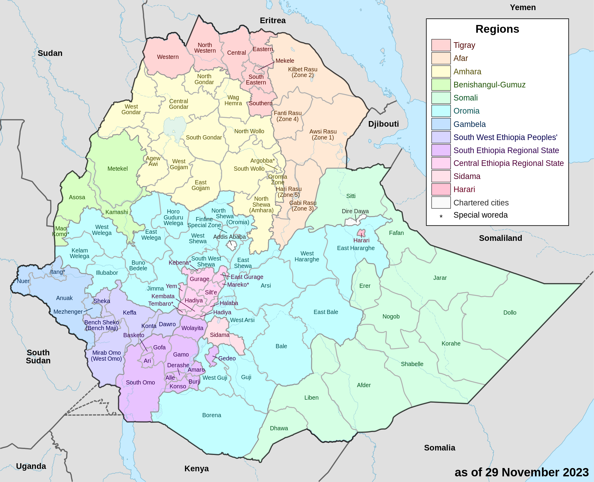
East Gojjam is bordered on the south by the Oromia Region, on the west by West Gojjam, on the north by South Gondar, and on the east by South Wollo; the bend of the Abay River defines the Zone's northern, eastern and southern boundaries. Its highest point is Mount Choqa (also known as Mount Birhan). Towns and cities in East Gojjam include Bichena, Debre Marqos, Debre Werq, and Mota.
This Zone was selected by the Ministry of Agriculture and Rural Development in 2004 as one of the several areas for voluntary resettlement for farmers from overpopulated areas; no specific woredas in this Zone were identified in this program. East Gojjam became the new home for a total of 20,000 heads of households and 80,000 total family members.[2]
Demographics
[edit]Based on the 2007 Census conducted by the Central Statistical Agency of Ethiopia (CSA), this Zone has a total population of 2,153,937, an increase of 26.68% over the 1994 census, of whom 1,066,716 are men and 1,087,221 women; with an area of 14,004.47 square kilometers, East Gojjam has a population density of 153.80. While 213,568 or 9.92% are urban inhabitants, a further 8 individuals are pastoralists. A total of 506,520 households were counted in this Zone, which results in an average of 4.25 persons to a household, and 492,486 housing units. The largest ethnic group reported in East Gojjam was the Amhara (99.82%); all other ethnic groups made up 0.12% of the population. Amharic is spoken as a first language by 99.81%; the remaining 0.19% spoke all other primary languages reported. 97.42% of the population said they practiced Ethiopian Orthodox Christianity, and 2.49% were Muslim.[3]
The 1994 national census reported a total population for this Zone of 1,700,331 in 381,993 households, of whom 845,980 were men and 854,351 women; 145,295 or 8.55% of its population were urban dwellers at the time. The largest ethnic group reported in East Gojjam was the Amhara (99.83%); all other ethnic groups made up 0.17% of the population. Amharic was spoken as a first language by 99.88%; the remaining 0.12% spoke all other primary languages reported. 96.71% practiced Ethiopian Orthodox Christianity, and 3.18% of the population said they were Muslim.[4]
According to a May 24, 2004 World Bank memorandum, 8% of the inhabitants of East Gojjam have access to electricity, this zone has a road density of 24.2 kilometers per 1000 square kilometers (compared to the national average of 30 kilometers),[5] the average rural household has 1.1 hectares of land (compared to the national average of 1.01 hectare of land and an average of 0.75 for the Amhara Region)[6] and the equivalent of 0.6 heads of livestock. 11.4% of the population is in non-farm related jobs, compared to the national average of 25% and a Regional average of 21%. 66% of all eligible children are enrolled in primary school, and 13% in secondary schools. 61% of the zone is exposed to malaria, and 30% to Tsetse fly. The memorandum gave this zone a drought risk rating of 447.[7]
Notes
[edit]- ^ Geohive: Ethiopia Archived 2012-08-05 at the Wayback Machine
- ^ "Resettlement 2004" Archived February 27, 2008, at the Wayback Machine, Disaster Prevention and Preparedness Agency (DPPA) (accessed 26 November 2006)
- ^ Census 2007 Tables: Amhara Region Archived November 14, 2010, at the Wayback Machine, Tables 2.1, 2.4, 2.5, 3.1, 3.2 and 3.4.
- ^ 1994 Population and Housing Census of Ethiopia: Results for Amhara Region, Vol. 1, part 1 Archived November 15, 2010, at the Wayback Machine, Tables 2.1, 2.11, 2.14, 2.17 (accessed 6 April 2009)
- ^ "Ethiopia - Second Road Sector Development Program Project", p.3 (World Bank Project Appraisal Document, published 19 May 2003)
- ^ Comparative national and regional figures comes from another World Bank publication, Klaus Deininger et al. "Tenure Security and Land Related Investment", WP-2991 Archived 2007-03-10 at the Wayback Machine (accessed 23 March 2006).
- ^ World Bank, Four Ethiopias: A Regional Characterization (accessed 23 March 2006).
10°20′N 38°00′E / 10.333°N 38.000°E
East Gojjam Zone
View on GrokipediaGeography
Location and Borders
East Gojjam Zone is situated in the Amhara Region of northwestern Ethiopia, encompassing a geographical extent from latitude 9.900° to 11.193° N and longitude 37.152° to 38.489° E.[18] This positioning places the zone within the central highlands of the country, contributing to its role as a key administrative and economic hub in the region. The zone covers a total land area of 14,010 km², reflecting its significant territorial size relative to other zones in Amhara.[19] The zone's boundaries are defined by neighboring administrative units and natural features, with the south bordering the Oromia Region, the west adjoining West Gojjam Zone, the north meeting South Gondar Zone, and the east interfacing with South Wollo Zone.[20] Notably, the Abay River (also known as the Blue Nile) serves as a prominent natural boundary along its southern perimeter, particularly the southwestern bend, with the Oromia Region, influencing regional connectivity and resource distribution.[20][8] Debre Markos, the capital and administrative center of East Gojjam Zone, is located at approximately 10.333° N latitude and 37.717° E longitude, at an elevation of about 2,440 meters above sea level.[21] As the zonal seat, it functions as the primary hub for government services, commerce, and transportation infrastructure, facilitating oversight of the zone's administrative divisions and supporting regional development initiatives.[22]Topography and Climate
The East Gojjam Zone exhibits a varied topography dominated by highland plateaus, rugged mountains, and incised river valleys, with elevations generally ranging from 1,800 to over 4,000 meters above sea level. This landscape is shaped by the dramatic gorge of the Abay River, which carves deep incisions along much of the zone's boundaries and influences local drainage patterns and soil distribution. Key features include the expansive Choke Mountains and plateaus such as Yetnora and Awabal, contributing to a predominantly undulating terrain that transitions from elevated plains to steep escarpments.[22][23] The zone's highest elevation is Mount Choqa, also referred to as Mount Birhan, which rises to approximately 4,100 meters and serves as a prominent landmark in the Choke Mountains range. This peak, located in the Sinan woreda, exemplifies the zone's alpine characteristics and supports unique microclimates amid the broader highland setting. The interplay of these topographic elements creates diverse ecological niches, from misty highlands to more sheltered valleys.[22][24] Climatically, East Gojjam falls within the temperate highland zone, featuring bimodal rainfall with a primary wet season from June to September and a secondary lighter period in March to May, yielding average annual precipitation of 1,000 to 1,500 mm that varies with elevation due to orographic effects. Mean temperatures hover between 15°C and 25°C annually, with cooler conditions in upland areas where frost occurrences pose seasonal risks, particularly above 3,000 meters during the dry months. These patterns support a moderately humid environment conducive to vegetation growth but also expose the region to variability influenced by broader Ethiopian highland dynamics.[25][26][27] Among the zone's natural resources, fertile volcanic and alluvial soils predominate across the plateaus and valleys, underpinning the region's productivity. Scattered indigenous forests, notably in the Choke Mountain ecosystem, provide biodiversity hotspots, while numerous tributaries of the Abay River offer reliable surface water sources that feed local hydrology. However, these forests face threats from deforestation and land degradation, as noted in recent environmental assessments. These elements collectively define the environmental foundation of East Gojjam, balancing resource abundance with topographic constraints.[28][23][29]History
Pre-Modern Period
The area comprising present-day East Gojjam formed part of the historical province of Gojjam, which is first documented in 14th-century Ethiopian manuscripts detailing the military campaigns of Emperor Amda Seyon (r. 1314–1344) against local Agaw rulers in the region. These records describe Gojjam as an Agaw kingdom that became a tributary to the expanding Solomonic state following Amda Seyon's conquests around 1316/17, marking its initial incorporation into the Christian highlands polity. The province's origins trace to interactions between indigenous Agaw (Cushitic-speaking) peoples, who were early settlers, and Semitic-speaking migrants from northern Ethiopia, including Amhara groups that gradually influenced the area's ethnolinguistic landscape through settlement and intermarriage. This peopling process reflected broader patterns of ethnic integration in medieval Ethiopia, where Agaw communities maintained distinct cultural practices amid encroaching Semitic influences. Christianization accelerated in the 16th century with a significant influx of monks from northern monasteries, who established key religious centers in Gojjam and spearheaded evangelization efforts among the Agaw and other local groups. This monastic migration, coinciding with the Solomonic dynasty's recovery from the devastating Adal invasions (1529–1543), transformed Gojjam into a stronghold of Orthodox Christianity, with monasteries serving as bases for restoring imperial authority and countering Islamic expansions. The region's monasteries not only preserved Solomonic legitimacy through hagiographic texts and liturgical traditions but also facilitated the resettlement of Christian Amhara populations, solidifying Gojjam's alignment with the dynasty during a period of territorial reconfiguration and ethnoreligious consolidation. Geographically enclosed by the Abay (Blue Nile) River, medieval Gojjam was governed by local warlords titled ras, who exercised de facto control over sub-regions amid fluctuating imperial oversight. These rulers navigated a landscape of semi-autonomy, balancing tribute to the Solomonic emperors with internal alliances among Agaw clans and emerging Amhara elites. A pivotal challenge was the resistance to Oromo expansions in the 16th and 17th centuries, as pastoral Oromo groups from the south (Liban and Tulama clans) raided and settled across Gojjam, prompting defensive campaigns by local ras and imperial forces to protect Christian highland territories. This period of conflict reshaped demographics, with Oromo integration through adoption (gudifacha) and military service gradually altering power dynamics. By the 17th century, Gojjam had evolved into a semi-autonomous kingdom under nominal Solomonic suzerainty, exemplified during the reigns of Emperors Susenyos (r. 1607–1632) and Iyasu I (r. 1682–1706), who relied on Gojjam's ras for military support while granting them leeway in local administration to secure loyalty. Susenyos's campaigns in the province, including battles against rival claimants near the Abay, highlighted Gojjam's strategic role in imperial consolidation, though local resistance to his Catholic experiments underscored its independent streak. Under Iyasu I, Gojjam's rulers facilitated Oromo resettlement south of the Abay, fostering a hybrid governance model that blended Agaw, Amhara, and Oromo elements.Modern and Contemporary Developments
During the late 19th century, Gojjam maintained significant autonomy within the expanding Ethiopian Empire under Emperor Menelik II, who ascended to the throne in 1889 following the death of Emperor Yohannes IV. Negus Tekle Haymanot, crowned ruler of Gojjam in 1881, allied with Menelik and retained local control, with Menelik restoring territories like Agaw Mider to him in 1890 as part of broader imperial consolidation efforts. This integration formalized Gojjam's incorporation into the centralized Ethiopian state while allowing hereditary rulers to govern provincially, a structure that persisted into the early 20th century.[30] In the early 20th century, Gojjam's autonomy was exemplified by Ras Hailu Tekle Haymanot, son of Tekle Haymanot, who assumed effective control of the province around 1920 and ruled until his removal in 1931 by Emperor Haile Selassie. Hailu imposed heavy taxation, such as the Yemedejja and Shumet Bejjé levies, to expand estates and consolidate power, often clashing with local Agaw groups in areas like Agaw Mider, which fueled regional discontent and contributed to his imprisonment in 1932 for aiding the exiled Lij Iyasu. This era marked the gradual erosion of provincial independence as the central imperial authority strengthened, culminating in Gojjam's full subordination during Haile Selassie's reign.[30] Following the overthrow of the Derg regime in 1991 by the Ethiopian People's Revolutionary Democratic Front (EPRDF), Gojjam province was restructured as part of Ethiopia's ethnic federalism, with the area divided into East Gojjam and West Gojjam zones in 1992 during the transitional government's administrative reorganization into ethno-linguistic regions. This split, formalized by 1996 under the Amhara National Regional State, separated the eastern highlands (East Gojjam) from the western portions, incorporating the latter with Awi Zone elements, to align with federal boundaries and promote localized governance. The formation of East Gojjam as a zone within the Amhara Region enhanced administrative efficiency but introduced challenges in resource allocation and inter-zonal coordination, impacting local decision-making on issues like land use and development.[31][28] In 2004, East Gojjam was designated as a key site for Ethiopia's voluntary resettlement program, aimed at relocating households from drought-prone northern areas to more fertile lands to combat food insecurity and reduce aid dependency. The initiative, part of a three-year effort targeting up to 2 million people nationwide, involved relocations to the zone, though reports highlighted concerns over inadequate infrastructure and health risks in the resettlement sites. The program was presented as consensual by the government but drew criticism from international observers for potential coercion and insufficient preparation.[32][33] Tensions between Amhara regional forces and the federal government escalated into armed conflict in August 2023, triggered by disputes over the disarmament of regional special forces and perceived marginalization, leading to widespread insurgency by Fano militias across the Amhara Region, including East Gojjam. The conflict, which continued through 2025, involved intense fighting, civilian displacements, and federal military operations, with the Ethiopian National Defense Force (ENDF) deploying drone strikes to target Fano positions. On April 17, 2025, an ENDF drone strike hit Gedeb town in the Enarj Enawga district of East Gojjam, killing over 100 civilians who were reportedly constructing a school fence, according to eyewitness accounts; local officials claimed the attack targeted militants, but it exemplified the conflict's toll on non-combatants amid over 70 recorded air strikes in the region since 2023, resulting in at least 669 civilian fatalities as of July 2025.[34][35][16][36] These developments strained local governance, exacerbating humanitarian needs and complicating administrative stability in the zone, with violence persisting into late 2025 without resolution.Administrative Divisions
Woredas
East Gojjam Zone is administratively divided into 16 rural woredas and 4 urban centers, which function as the fundamental units of local governance responsible for implementing regional policies in areas such as rural development, resource management, and community services.[37] These districts primarily encompass rural landscapes dedicated to subsistence agriculture, with each woreda overseeing kebeles (the smallest administrative units) to facilitate decentralized administration under the Amhara National Regional State. The woredas vary in topography and economic focus, contributing to the zone's overall agrarian economy while addressing local challenges like soil conservation and water resource allocation. The woredas include Aneded, Awabel, Baso Liben, Bibugn, Debay Telatgen, Dejen, Enarj Enawga, Enbise Sar Midir, Enemay, Goncha Siso Enese, Guangua, Hulet Ej Enese, Machakel, Shebel Berenta, Sinan, Yilmana Densa, Gozamen, and Debre Elias. Each plays a vital role in coordinating agricultural extension services and infrastructure maintenance, with central woredas exhibiting higher administrative densities due to their proximity to the zone's capital.- Aneded: This woreda is characterized by its highland terrain suitable for teff and barley cultivation, serving as a key area for soil erosion control initiatives through terracing programs implemented at the local level.
- Awabel: Focused on mixed farming systems, Awabel manages community-based forestry projects to combat deforestation, emphasizing sustainable land use in its governance structure.[38]
- Baso Liben: A predominantly rural district, it prioritizes livestock rearing alongside crop production, with local administration supporting veterinary services for smallholder farmers.
- Bibugn: Known for its fertile valleys, Bibugn's administrative efforts center on irrigation schemes to enhance maize yields in semi-arid pockets.
- Debay Telatgen: This woreda governs diverse agro-ecological zones, promoting conservation agriculture to maintain soil fertility for pulse crops.[9]
- Dejen: Positioned near the Abay River, Dejen acts as a transportation corridor, with its local government facilitating road maintenance and riverine trade logistics.[39]
- Enarj Enawga: A rural agriculture-focused woreda, it was the site of a devastating drone strike on April 17, 2025, that killed over 100 civilians gathered at a school in Gedeb town, highlighting ongoing security challenges in local administration.[40]
- Enbise Sar Midir: Emphasizing highland farming, its governance includes watershed management to support wheat production and prevent flooding.[41]
- Enemay: This district coordinates beekeeping and honey production initiatives, integrating them into its rural economic development plans.[9]
- Goncha Siso Enese: Centered on cereal crops, the woreda's administration oversees cooperative farming groups for equitable resource distribution.[41]
- Guangua: Featuring lowland areas, it focuses on sesame and sorghum cultivation, with local governance addressing drought resilience through afforestation.[39]
- Hulet Ej Enese: As a central woreda with higher administrative density, it manages extensive farmlands for teff, supporting zone-wide agricultural extension services.
- Machakel: This woreda promotes agroforestry to bolster coffee and fruit tree cultivation in its mid-altitude regions.[39]
- Shebel Berenta: Involved in river basin management, its local structures facilitate small-scale hydropower and fishing along tributaries.
- Sinan: Governance here emphasizes potato farming in cooler highlands, with programs for seed multiplication and storage.[9]
- Yilmana Densa: A densely administered rural area, it coordinates community health and sanitation drives alongside staple crop production.[9]
- Gozamen: Bordering the Abay River, this woreda's administration supports bridge maintenance and flood mitigation for agricultural continuity.[42]
- Debre Elias: Focused on transitional agro-ecologies, it governs efforts to integrate legumes into rotations for soil health improvement.[39]