Hubbry Logo
MonsarazMonsarazMain
Open search
Monsaraz
Community hub
Monsaraz
logo
8 pages, 0 posts
0 subscribers
Be the first to start a discussion here.
Monsaraz
Monsaraz
from Wikipedia

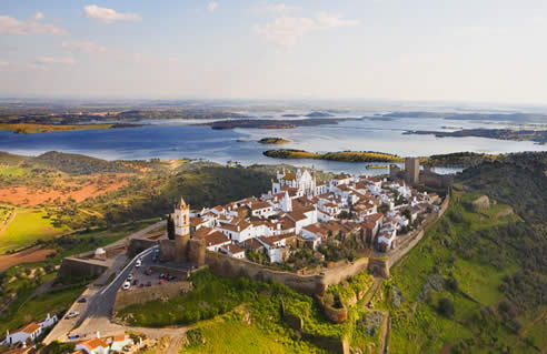
Monsaraz is a civil parish (freguesia) of the municipality of Reguengos de Monsaraz, on the right margin of the Guadiana River in the Portuguese Alentejo region, near its border with Spain. The population in 2011 was 782,[1] in an area of 88.29 km2.[2]

Key Information

History

[edit]
The Megalithic monuments of the Cromlech of Xerez

Due to its geographic position, the hilltop of Monsaraz always occupied an important place in the history of the municipality, having been occupied by different peoples since the pre-historical record.[3] It is one of the oldest settlements in southern Portugal, occupied since pre-history, with examples of permanent habitation including hundreds of megalithic monuments. These include the Neolithic remains of: Megalithic Monuments of Herdade de Xerez, Olival da Pega Dolmens, Menhir of Bulhoa, Rocha dos Namorados Menhir and Outeiro Menhir. The hill, on which the main settlement is located, was a pre-historic fortification, or castro, that was the basis of pre-Roman occupation and funerary temples, carved from the local rock.

Monsaraz was reorganized during the Roman occupation, and was later successively occupied by the Visigoths, Arabs, Mozarabs, Jews, and, after the Reconquista, Christians loyal to Afonso Henriques. In the 8th century, Monsaraz fell under the dominion of Arab forces who occupied the Iberian Peninsula, becoming known as Saris or Sharish, and following the control of the Taifa of Badajoz (one of the more prominent Arab centres at the time).[3] The name Monsaraz originates from the word Xarez or Xerez, the Iberian transliteration of the Arabic Saris or Sharish, for the Gum Rockrose (Cistus ladanifer L.), a plant that still today prospers in poor, dry, acidic slate-based soil that surrounds Monsaraz. The Iberian words Xarez/Xerez latter evolved to the Portuguese Xaraz and to the Spanish (Castilian) Jerez (the Spanish name for the sherry wine). The settlement therefore came to be known as Monsaraz, originating from Monte Xaraz, i.e., fortified hill surrounded by Gum Rockroses. Its naturally prominent position, being the highest hill in the area as well as its proximity to the deep Guadiana valley, made it a location of strategic importance.

The Castle keep of Monsaraz, centre of tourism in the parish

In 1167, the Castle and medina was taken by Geraldo Sem Pavor, in an expedition that came from Évora (which had just been retaken, about the same time).[3] After, Afonso Henriques' defeat in Badajoz, Monsaraz was once again taken by Muslim forces.[3] In 1232, supported by the Knights Templar, King Sancho II definitively retook the citadel and town, placing it under the control of the Templars, and obligating them to establish a garrison that would protect the border.[3] The Christian repopulation of Monsaraz ended around the reign of Afonso III, when it was assigned an alcalde, the knight Martim Anes, and first letter of foral.

In 1263 it was already an important fortress, being the head of a municipality, with large privileges. The local economy was fundamentally based on agriculture and livestock, existing some small artesnal industries producing terra cotta earthenware and hammered copper.

After the Portuguese Interregnum (1383-1385), the town of Monsaraz was integrated into the dominions of the House of Braganza under Nuno Álvares Pereira.[3] By 1412, it is inherited by Fernando, his son, becoming one of the more precious profit centres in the Ducal estates.

In 1512, King Manuel of Portugal issued a foral (charter) to the Vila de Monsaraz, reformulating the public and jurisdictional administration of the municipality.[3]

The demographic crises created by the plague forced the Duke of Bragança, in 1527 to carry out small land reforms in order to promote the settlement Monsaraz. The small plots were established in the area surrounding this village.

Following the Portuguese Restoration War, in 1640, the castle received new tactical defenses, that included a new walled bastion, that allowed the city-fort to be integrated into the system of defences that connected Elvas, Juromenha, Olivença and Mourão.[3]

View from Monsaraz, Portugal

The condition of the walled medieval city, the growth of the farm estates of Reguengos, the richness of the artesnal production and vineyards, and more importantly, the loyalty towards the Miguelist forces during the Liberal Wars were all factors that contributed to the shifting of the municipal seat from Monsaraz to Vila Nova de Reguengos in 1838,[3] a fact that became permanent after 1851.[3]

Geography

[edit]

The parish of Monsaraz is located in the northeast corner of the municipality of Reguengos de Monsaraz fronting the Guadiana River and Alqueva Dam to the east, Corval to the west and Campinho to the south in the municipality of Reguengos de Monsaraz. Across the reservoir to the east is the parish of Mourão (in the municipality of Mourão) and to the north the parish of Capelins (in the municipality of Alandroal).

Architecture

[edit]

Prehistoric

[edit]
The Megalithic Monuments of Herdade de Xerez, showing the age of the region

Civic

[edit]
  • Casa da Inquisição
  • Casa da Roda dos Expostos
  • Casa do Juíz de Fora
  • Cine Monsaraz
  • Cistern of Monsaraz
The white-washed Mannerist fountain of the Telheiro
  • Fountain of the Telheiro
  • Mill of Água do Gato
  • Novos Paços do Concelho
  • Paços da Audência
  • Pillory of Monsaraz
  • Restaurante Sem Fim/Lagar

Military

[edit]
Watchtower of São Gens do Xarez.
  • Fortifications of Monsaraz
  • Watchtower of São Gens do Xarez (Atalaia de São Gens/Torre de São Gens do Xarez), a simple, square watchtower oriented to the cardinal points, but in a state of ruin, making reconstitution difficult, likely built in 1646 to guard the Guadiana River;[4]

Religious

[edit]
  • Chapel of São Bento (Capela de São Bento/Ermida de São Bento), a rural chapel constructed at the end of the 16th century-beginning of the 17th century, through contributions of many of the local residents of Arrabalde da Vila, that includes frescos in a vaulted ceiling. After the 1755 Lisbon earthquake the building was left seriously damaged;[5]
  • Chapel of São João
The pillory of Monsaraz across from the square from the Parochial church of Nossa Senhora da Lagoa
  • Church of Nossa Senhora de Lagoa
  • Church of Santiago Maior
  • Church of the Convent of Nossa Senhora da Orada
  • Church of the Misericórdia of Monsaraz
  • Hermitage of Nossa Senhora do Carmo
  • Hermitage of São João Baptista
  • Hermitage of São Lázaro
  • Hermitage of São Sebastião
  • Hermitage of Santa Catarina de Monsaraz

References

[edit]
[edit]
Revisions and contributorsEdit on WikipediaRead on Wikipedia
from Grokipedia
Monsaraz is a small medieval village and civil parish (freguesia) in the municipality of Reguengos de Monsaraz, situated in Portugal's Alentejo region within Évora District, elevated on a granite hilltop that commands views over the Guadiana River valley and the expansive Alqueva Reservoir. Evidence of human occupation traces to prehistoric eras, marked by nearby megalithic sites including the Cromlech of Xerez—a Neolithic stone circle—and various menhirs, reflecting early fortified settlements in the area. The village was seized from Moorish forces in 1167 by Geraldo Sem Pavor, a key figure in the Reconquista, though it later changed hands before being definitively secured for Portugal under King Afonso Henriques; this event underscores its longstanding strategic military importance. Dominating the skyline is the 13th-century Castle of Monsaraz, a Gothic fortress with robust walls encircling the historic core of whitewashed adobe houses, narrow cobblestone alleys, and ecclesiastical structures like the Church of Santiago, all designated as a National Monument since 1946 for their exemplary preservation of medieval architecture. Recognized as one of Portugal's Seven Wonders of Village Architecture, Monsaraz exemplifies Alentejo's cultural heritage, bolstered by the Alqueva Dam's completion in 2002, which transformed the landscape into a reservoir supporting tourism, astronomy via dark skies, and local viticulture while highlighting the site's enduring appeal as a vantage point for observing the region's cork oak plains and distant Spanish border.

Geography

Location and Topography

Monsaraz is a civil parish in the municipality of Reguengos de Monsaraz, within the Évora District of Portugal's Alentejo region, positioned on the right margin of the Guadiana River in southern Portugal. Its geographic coordinates are approximately 38.44°N latitude and 7.38°W longitude. The settlement occupies a granite hilltop that rises to an elevation of 326 meters above sea level, dominating the local terrain and historically providing strategic oversight of the surrounding area. The topography of Monsaraz features undulating plains typical of the , with the hill serving as a prominent amid lower grasslands, vineyards, groves, and cork woodlands. To the south, the includes the expansive Alqueva , formed by the on the , which creates Europe's largest artificial lake and enhances the region's visual and hydrological profile. This elevated position affords extensive vistas across the arid, rolling countryside, underscoring the site's defensibility and prominence in the .

Climate and Environmental Features

Monsaraz experiences a hot-summer Mediterranean climate (Köppen Csa), characterized by mild, wet winters and hot, dry summers. Average annual temperatures range from about 17.2°C to 17.4°C, with extremes varying between 5°C and 33°C, rarely dropping below 1°C or exceeding 38°C. July sees average highs of 35°C, while January lows average around 6°C to 8°C. Precipitation totals approximately 500 mm annually, concentrated in winter months, with around 95 rainy days per year and minimal summer rainfall. The local environment features a hilly granite outcrop rising above surrounding plains, now adjacent to the expansive Alqueva Reservoir formed by the Alqueva Dam completed in 2002. This artificial lake, Europe's largest, has altered regional hydrology, supporting irrigation for agriculture while creating a lacustrine ecosystem that influences microclimates and biodiversity. Vegetation includes typical Alentejo montado systems with scattered cork oaks (Quercus suber) and holm oaks (Quercus ilex), alongside olive groves and dryland cereals, adapted to the semi-arid conditions. Biodiversity reflects the Mediterranean hotspot, with agroecosystems hosting diverse and amid human-managed landscapes. The reservoir vicinity supports aquatic and populations, though the predominantly agricultural setting limits endemic richness compared to more reserves. types, primarily schists and granites, contribute to risks in the undulating , exacerbated by seasonal .

History

Prehistoric and Megalithic Settlements

The region surrounding Monsaraz in Portugal's province features extensive of prehistoric activity to the period, approximately 5500 to 3000 BC, characterized by the of megalithic monuments such as dolmens, menhirs, and cromlechs. These structures indicate organized communities engaged in , , and ritual practices, with the area's schist and granite landscapes providing materials for enduring stone edifices. hosts one of Europe's highest densities of such sites, with over 800 dolmens and numerous enclosures documented in the Évora district alone, suggesting Monsaraz's vicinity served as a focal point for early sedentary populations. Prominent among local megalithic complexes is the Cromeleque do Xerez, a Neolithic enclosure originally located about 5 km south of Monsaraz in a small valley opposite Monte do Xerez. Comprising approximately 50 elongated granite menhirs averaging 1.20 to 1.50 meters in height arranged in a circular or elliptical formation, the site likely functioned for ceremonial or astronomical purposes, with a central taller menhir exceeding 4 meters. Dated to the 5th or 4th millennium BC based on archaeological context, the cromlech was excavated in 1998 prior to relocation northward to Telheiro near the Convento da Orada, necessitated by the flooding from the Alqueva Dam reservoir. Additional monuments in the immediate vicinity include the Menhir do Outeiro, a solitary standing stone from the same Neolithic era, and the Menhir de Bulhôa, situated at the base of Monsaraz hill between Outeiro and Telheiro, forming part of a broader megalithic cluster evidencing prolonged prehistoric occupation. These sites, preserved amid the undulating plains, underscore the area's role in Iberian prehistory, where megalithic builders exploited elevated positions for visibility and defense, predating later Celtic influences in the region.

Roman, Visigothic, and Early Medieval Periods

The prehistoric castro settlement on Monsaraz's hilltop was conquered and romanized by Roman forces around the 2nd century BCE, integrating it into the province of Lusitania as a fortified outpost leveraging its strategic elevation for defense and oversight of surrounding agro-pastoral lands. Archaeological indications confirm reoccupation during Roman times atop earlier Iron Age layers, though specific artifacts or structures from this era remain limited in documentation, suggesting continuity of local settlement patterns rather than major urban development. With the waning of Roman imperial control in the 5th century CE, Visigothic forces assumed dominance over the Iberian Peninsula, including Monsaraz, circa 500 CE, preserving the site's role as a modest inhabited center amid the kingdom's decentralized rural economy. This early medieval phase under Visigothic rule, extending until the Umayyad Muslim conquest of 711 CE, featured no recorded major events or fortifications unique to Monsaraz, aligning with broader regional patterns of cultural and administrative transition without evident disruption to basic settlement functions.

Islamic Occupation and Christian Reconquest

Following the Muslim conquest of the Iberian Peninsula in 711 CE, Monsaraz fell under Islamic control during the early 8th century, becoming known as Saris or Sharish and administered as part of the district of Mértola in Al-Andalus. The site's elevated hilltop location provided strategic defensive advantages, likely contributing to its fortification under Muslim rule as a regional outpost amid the broader Umayyad and later Taifa governance structures. The initial Christian assault occurred in 1167, when Portuguese forces under the command of the knight —known as —captured the settlement from Muslim defenders during a military expedition launched from the nearby city of Évora, which had itself been recently reconquered. This victory, achieved on behalf of , represented an early advance in the Portuguese efforts against Almoravid-held territories. Control proved ephemeral, as Almohad Caliph reasserted Muslim dominance in 1173, recapturing Monsaraz after Portuguese defeats in the broader campaign, including the loss at Badajoz. The town remained under Almohad for nearly six decades, serving as a frontier stronghold until the resurgent Christian campaigns of the 13th century. The permanent reconquest materialized in 1232 under , whose forces definitively seized Monsaraz from the weakening Almohad defenses, integrating it securely into and ending centuries of Islamic occupation. This event aligned with the broader southward push of the , solidifying Portugal's southern borders against residual Muslim polities.

Medieval Fortification and Royal Portuguese Era

Following the Christian reconquest, Monsaraz was captured from Muslim forces in 1232 by King Sancho II of Portugal with the assistance of the Knights Templar, after an earlier brief seizure in 1167 by Gerald the Fearless and subsequent loss to the Almohads in 1173. The Knights Templar were granted control of the site and initiated its fortification as a strategic hilltop stronghold to secure the frontier against Moorish and later Castilian threats. In 1276, King Afonso III issued a charter to Monsaraz, promoting population growth and defensive enhancements, which laid the groundwork for expanded castle construction. By the early 14th century, King Denis I (D. Dinis) oversaw the reconstruction of the keep and the erection of encircling town walls, completed around 1309, transforming Monsaraz into a robust medieval fortress with battlements and towers. This development underscored its role as a key royal outpost in the Portuguese kingdom, facilitating border defense during recurrent conflicts with Castile, including a Castilian occupation in 1385 amid the Portuguese Interregnum, swiftly reversed upon John I's accession. The village's architecture, including the castle's prominent keep, served administrative functions under royal oversight, with the site later transferred to the Order of Christ in 1319 following the Templars' suppression and donated to the in 1412, integrating it deeper into Portugal's noble and monarchical framework. Throughout the medieval period, Monsaraz's elevated position and fortifications enabled it to withstand sieges, such as an English in 1381 during allied campaigns, reinforcing its enduring significance in Portugal's territorial consolidation.

Modern Developments and Infrastructure Changes

The most significant modern infrastructure project impacting Monsaraz was the construction of the Alqueva Dam as part of the Alqueva Multipurpose Project, with work commencing in 1995 and completion in 2002. This arch dam on the Guadiana River created Europe's largest artificial reservoir, Lake Alqueva, with a storage capacity of 4,150 cubic hectometers, providing water for irrigation, hydroelectric power generation, and flood control across the Alentejo region. Positioned on a hilltop overlooking the reservoir, Monsaraz benefited from enhanced scenic vistas that transformed the local landscape and spurred tourism infrastructure development. The lake's presence led to the concentration of over half of the hotels and tourist facilities in the broader Municipality of Reguengos de Monsaraz within the village itself, fostering economic growth through increased visitor influx while emphasizing sustainable practices to preserve the medieval heritage. Ongoing hydraulic and irrigation enhancements, such as the 2024 Reguengos de Monsaraz hydraulic circuit and Peral block projects executed by FCC Construcción , continue to support agricultural modernization in the area, interconnecting with the Alqueva for improved distribution. The reservoir's integration of hydroelectric facilities and recent additions like panels has further diversified energy , contributing to regional efforts without altering the village's core historic fabric.

Demographics and Administration

Population and Social Composition

As of the 2021 Portuguese census, the civil parish of Monsaraz recorded a resident population of 658 inhabitants, reflecting a decline from 782 in the 2011 census, consistent with broader depopulation trends in rural Alentejo due to emigration and low birth rates. The parish spans 88.29 km², yielding a low population density of approximately 7.45 inhabitants per km², underscoring its sparse, agrarian character. Demographic for the indicate an aging typical of inland , with the encompassing municipality of Reguengos de Monsaraz showing an average age of 46.6 years, a slight (51.5%), and foreigners comprising 3.1% of , primarily economic migrants in rather than altering the overwhelmingly ethnic composition. Socially, the remains homogeneous and rooted in traditional Alentejo rural , with most households engaged in farming, , and , and no significant ethnic minorities or urban influx reported in official statistics. This structure perpetuates a conservative, family-oriented society, with high reliance on extended kinship networks amid ongoing challenges from youth outmigration to coastal urban centers.

Governance and Local Economy

Monsaraz functions as a civil parish (freguesia) within the municipality of Reguengos de Monsaraz, located in Portugal's Évora District in the Alentejo region. The parish is governed by an elected Junta de Freguesia, which handles local administrative matters such as community services, maintenance of public spaces, and cultural events. The current president of the Junta de Freguesia is Nuno Isidro de Ambrósio Pinto, supported by a secretary and treasurer, as per the parish's official composition for the ongoing term. At the municipal level, the Câmara Municipal de Reguengos de Monsaraz oversees broader policy, infrastructure, and economic development, led by President Marta Sofia da Silva Chilrito Prates of the Social Democratic Party (PSD), elected in local elections. The local economy of Monsaraz and its surrounding parish relies heavily on , particularly , cultivation, and cork production, which are staples of the Alentejo's agrarian . Wine production stands out, with nearby vineyards contributing to regional appellations and supporting tours and tastings that attract visitors. farming and small-scale artisanal industries, such as , complement these activities, though they remain secondary. Tourism has emerged as a vital economic driver since the completion of the Alqueva Dam in 2002, which formed Europe's largest artificial lake and enhanced Monsaraz's appeal as a historic hilltop destination. The influx of tourists supports hospitality, guided excursions to local farms for olive oil and wine experiences, and seasonal events, helping to diversify income beyond traditional farming. Municipal statistics indicate an employment rate of approximately 48% and an average monthly salary around €984, reflecting the rural character and modest scale of economic activity in the broader Reguengos de Monsaraz area.

Built Heritage

Prehistoric Monuments

The area around Monsaraz features numerous megalithic monuments from the Neolithic period, spanning roughly 5500 to 3000 BCE, reflecting early human settlement and ritual practices in the Alentejo region, which hosts one of Europe's highest concentrations of such sites. Monsaraz itself shows evidence of prehistoric occupation, with the hilltop location likely serving as a fortified settlement during this era. The Cromlech of Xerez, situated near Monsaraz in the Reguengos de Monsaraz municipality, comprises approximately 50 granite menhirs of phallic form, each 1.2 to 1.5 meters tall, arranged in a square enclosing a taller central menhir up to 4 meters high. Dating to between 4000 and 3000 BCE, the site was partially reconstructed in modern times, preserving its original Neolithic configuration as a ceremonial enclosure. The Menir do Outeiro, known locally as Penedo Comprido, stands 5.6 meters high with a 1-meter diameter, weighing an estimated 8 tonnes, making it the second-tallest menhir in Portugal. Located about 5 kilometers north of Monsaraz between the villages of Outeiro and Barrada, this phallic granite monolith also originates from the Neolithic era and forms part of a broader megalithic cluster in the vicinity. Other nearby structures, such as the Menhir of Bulhoa, contribute to the density of standing stones and enclosures that characterize the prehistoric landscape.

Military Architecture

The military architecture of Monsaraz is epitomized by its medieval castle and the encircling defensive walls that integrate the village into a cohesive fortress system, strategically positioned on a hill between 275 and 325 meters elevation for panoramic surveillance over the surrounding plains and Guadiana River valley. The castle, reconstructed by King Dinis I in 1310 upon preexisting defenses originating from prehistoric enclosures and enhanced during the Christian Reconquista after the site's recapture from Muslim forces in 1167, adopts a quadrangular layout with robust walls of schist masonry bound by lime mortar, buttressed by multiple towers including the prominent keep or Torre de Menagem. These walls, predating gunpowder artillery, emphasize height and mass for resistance against siege engines, with the entire intramural ensemble expanded under kings such as Sancho II and Afonso III to enclose the settlement fully. Four principal gates pierce the perimeter, constructed with durable granite ashlar; the primary Porta da Vila is guarded by paired semicylindrical towers, while others like the Porta de Alcáçova facilitate controlled access and enfilade fire. The Torre de Menagem, as the innermost stronghold, functioned as a final refuge, command center, and lookout, underscoring the site's role in medieval frontier defense against incursions. In the 17th century, amid the Portuguese Restoration War against Spain, adaptations for firearm-era tactics included bastioned extensions and earthworks inspired by advanced European engineering, enhancing angular bastions for artillery coverage. Strategic relevance waned by the 18th century with shifting borders and military doctrines, leading to abandonment of active fortifications around 1830; thereafter, the castle's interior repurposed for uses, though the structures endured multiple sieges across centuries without total destruction.

Religious Structures

The principal religious structure in Monsaraz is the Igreja Matriz de Nossa Senhora da Lagoa, the parish church dedicated to Our Lady of the Lagoon, constructed in the 16th century on the site of a preceding 13th-century temple. The church features a fortress-like exterior reflective of the village's defensive medieval context and underwent significant reconstructions following the 1755 Lisbon earthquake as well as in the 19th century. Its interior preserves elements from the 16th and 17th centuries, including altarpieces and azulejo tiling, though ongoing renovations address seismic damage and wear. Adjacent to the parish church, the Igreja de Santiago, a smaller Gothic-influenced chapel, dates to the medieval period and was recently restored to highlight its in local devotion during the Christian reconquest . The Igreja de São Bartolomeu, another modest parish-affiliated structure, serves commemorative functions tied to the village's agrarian saints' . The Capela de São José, a chapel built in by local patron Domingos Lourenço Perdigão, occupies the upper floor of a residential building on Rua Direita, accessible via an external , and exemplifies private devotional integrated into Monsaraz's dense urban fabric. Additionally, the 16th-century Igreja da Misericórdia adjoins the former do , functioning historically for charitable care and retaining portal amid its central village placement. These structures collectively underscore Monsaraz's post-reconquest Christianization, with emphases on seismic resilience and community patronage rather than grand ecclesiastical patronage.

Civic and Residential Features

The residential architecture of Monsaraz exemplifies traditional Alentejo vernacular style, featuring compact, whitewashed stone houses with terracotta-tiled roofs clustered densely within the medieval walls to maximize defensive compactness and communal living. These dwellings, often constructed from local schist and lime, incorporate simple facades with minimal ornamentation, narrow windows for thermal regulation in the hot climate, and shared courtyard spaces that foster social interaction among the village's small population of approximately 136 residents as of recent censuses. The layout emphasizes organic, winding cobblestone streets—such as Rua Direita—that weave between homes, adapting to the hilltop terrain while preserving the fortified village's insular character, with little modern expansion due to heritage protections. Civic features center on structures tied to historical municipal authority and public assembly. The Pelourinho de Monsaraz, a marble pillory rebuilt in the 18th century following the 1755 Lisbon earthquake's destruction of its predecessor, stands in the principal square adjacent to the Igreja Matriz, serving as a enduring symbol of local justice, commerce oversight, and royal prerogative under Portuguese municipal traditions. More substantively, the Antigos Paços de Audiência—now repurposed as the Museu do Fresco—represents the village's foremost historic civil edifice, originally functioning as the audience hall for judicial proceedings, administrative hearings, and concelho (municipal council) sessions until the seat transferred to Reguengos de Monsaraz in 1838. This building, located on the eastern facade of Rua Direita, underscores Monsaraz's pre-19th-century role as the regional administrative hub, with its architecture reflecting noble civic proportions through vaulted interiors and schist detailing. Public infrastructure remains minimal and integrated with heritage preservation, lacking expansive modern civic complexes; instead, communal functions historically converged in the castle-adjacent praça de armas, where markets and gatherings occurred amid the encircling walls. Contemporary residential and civic upkeep falls under the Reguengos de Monsaraz municipality's urbanismo regulations, which prioritize rehabilitation of existing fabric over new to maintain the site's classified status as a national monument.

Cultural and Economic Significance

Traditional Culture and Festivals

The traditional culture of Monsaraz embodies the rural Alentejo heritage, centered on cante alentejano, a polyphonic, a cappella singing tradition performed by amateur choral groups in two parts—melody and counter-melody—reflecting themes of daily life, work, and emotion, and recognized by UNESCO as Intangible Cultural Heritage in 2014. This practice, rooted in the region's agrarian past, is commemorated locally by a monument near the castle depicting choral performers, underscoring its enduring role in community identity. The annual Festa do Cante, held on 25 and 26 , preserves this custom through a parade of groups such as "Estrelas do " and "Os Ganhões" de Castro Verde along Rua Direita, followed by a gala in featuring by artists like Beatriz Felício and Manuel Sérgio, emphasizing the genre's authenticity in a medieval setting. In , the village hosts medieval-themed events, functioning as an open-air museum with markets, artisan workshops in schist crafts, and reenactments of historical customs, evoking the site's fortified past and regional folklore. The Festa em Honra de Nosso Senhor dos Passos, from 11 to 15 , blends Catholic devotion with folk elements, including processions, the Monsaraz Wine , , and where campinos demonstrate traditional bull-handling skills without intervention. Additional observances, such as the of Our Lady of the Conception, feature communal gatherings reinforcing and seasonal .

Wine Production and Agriculture

The economy of Reguengos de Monsaraz, encompassing the village of Monsaraz, centers on viticulture as a cornerstone of agricultural output, with vineyards covering extensive areas suited to the Alentejo's Mediterranean climate and diverse soils including granite, schist, and limestone derivatives. Large-scale operations like the CARMIM cooperative process grapes from 3,000 hectares managed by approximately 700 grower associates, making it the region's largest winery by volume. Estates such as Herdade do Esporão maintain 692 hectares of organically farmed vineyards, cultivating around 40 grape varieties alongside olive groves and other crops, with hand-harvesting emphasizing quality over mechanized efficiency. Wine production traces to Roman-era in , though interrupted by invasions including the Moorish period starting in 711 AD, with systematic revival occurring in the 1970s through modern systems and in native varietals like Aragonez and Antão Vaz. Traditional methods persist, as seen in secular wineries operational since 1880 and the use of clay amphorae for aging, which preserve ancient techniques while integrating for precision control. Beyond wine, agriculture incorporates olive cultivation, with centenarian trees on estates yielding up to 800 kilograms per mature specimen annually, supporting premium extra-virgin olive oil production from varieties adapted to the schistous terrain. Cereal crops, including wheat and barley, dominate extensive dryland farming, supplemented by organic vegetable gardens, fruit orchards, and cork oak plantations that leverage the montado system's agroforestry for sustainable yields. The Alqueva reservoir, formed by the 2002 dam completion, has bolstered irrigation-dependent expansion, though traditional rain-fed practices remain prevalent to maintain soil health and resist overexploitation.

Tourism Impact and Preservation Challenges

Tourism in Monsaraz has significantly contributed to the local economy, leveraging the village's medieval architecture, prehistoric sites, and panoramic views over the Alqueva Reservoir, which attracts visitors for water-based activities, stargazing in the International Dark Sky Reserve, and cultural experiences. The proximity to the Alqueva Lake, Europe's largest artificial reservoir completed in 2002, has amplified visitor interest, with activities such as boating, kayaking, and beach visits drawing tourists to the region, indirectly benefiting Monsaraz through day trips and overnight stays in nearby accommodations. This influx supports rural tourism initiatives in the Alentejo, promoting sustainable practices that emphasize low-impact development to preserve natural and cultural assets. Despite these benefits, preservation challenges arise from balancing increased visitation with the maintenance of Monsaraz's historic integrity, a small hilltop settlement with fewer than 1,000 residents, many elderly, which risks depopulation without economic diversification. Efforts by local entities, such as Herdade do Esporão, focus on studying and funding the conservation of megalithic and built heritage to mitigate wear from foot traffic on ancient structures like the castle walls and schist pathways. Urban conservation strategies in Central Alentejo, including Monsaraz, aim to enhance liveability while addressing authenticity loss from potential over-commercialization, though current tourism levels remain managed to avoid the overcrowding seen in other Portuguese sites. Restoration projects, such as those on fortifications, prioritize historical continuity and landscape identity to counteract erosion and structural decay exacerbated by environmental exposure and visitor access. The municipality of Reguengos de Monsaraz employs data collection on tourist profiles to assess risks, impacts, and capacity limits, ensuring heritage protection aligns with economic gains.

References

Add your contribution
Related Hubs
User Avatar
No comments yet.