
Community hub
Recent from talks
Contribute something
Nothing was collected or created yet.
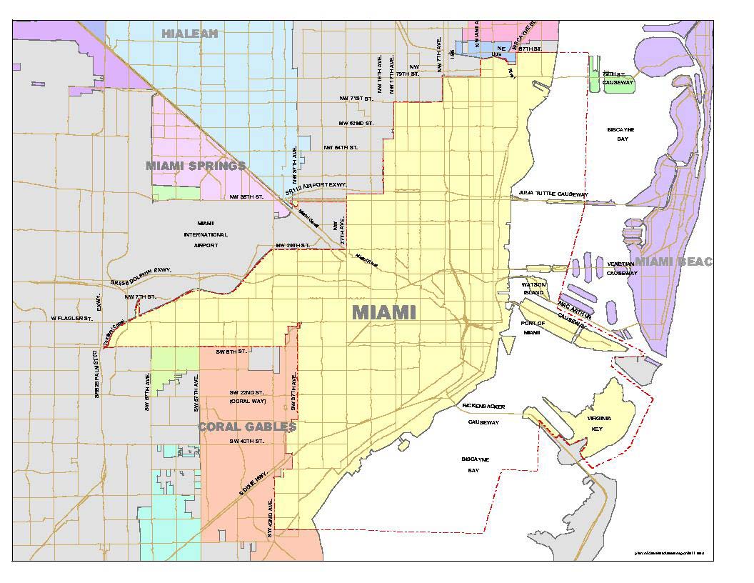
List of neighborhoods in Miami
View on Wikipedia


This is a list of neighborhoods in Miami in Miami-Dade County, Florida, United States. Many of the city's neighborhoods have been renamed, redefined and changed since the city's founding in 1896. As such, the exact extents of some neighborhoods can differ from person to person. The following is the list of all the city's major neighborhoods, including any corresponding sub-neighborhoods within them.
Brickell is at the center of the Miami core. Its borders are Interstate 95 to the west, Brickell Bay to the east, the Miami River to the north, and Rickenbacker Causeway to the south. Coconut Grove is an example of a neighborhood whose size and name has stayed relatively the same since its settlement in 1825. Having been settled originally as "Cocoanut Grove", its character has stayed almost intact from its early days.[1] In contrast, other neighborhoods have undergone many name and size changes. Buena Vista was once a much larger neighborhood in the 1920s than it is today. Buena Vista once consumed all of the Miami Design District as well as a large part of Little Haiti, Wynwood and Edgewater. Other neighborhoods, such as the Arts & Entertainment District, were previously branded as "Omni", after the Omni Mall that was located there in the 1980s and 1990s. Midtown emerged as a new neighborhood in the mid-2000s after developers created the large scale Midtown Miami development in an area traditionally known as Edgewater.
See also
[edit]References
[edit]- ^ Planning Your Vacation in Florida, Miami and Dade County [WPA Guide to Miami], Northport, NY: Bacon, Percy & Daggett, 1941, page 49.
- ^ "Mapping America: Every City, Every Block". The New York Times. December 13, 2010 – via www.nytimes.com.
External links
[edit]

List of neighborhoods in Miami
View on GrokipediaBackground
Historical Development
The Miami area was originally inhabited by the Tequesta people for thousands of years before European contact in the 16th century.[6] Miami's origins trace back to the late 19th century, with the city officially incorporated on July 28, 1896, following the arrival of the Florida East Coast Railway spearheaded by Henry Flagler, which facilitated settlement around Biscayne Bay.[7] Initial development focused on waterfront areas for trade and agriculture, drawing pioneers to establish small communities. Coconut Grove, one of the earliest settlements, predated the city's founding, with Bahamian families like the Pents and Frows arriving in the 1880s to farm and fish, building on the site's prior use since the construction of the Cape Florida Lighthouse in 1825.[8] These early patterns laid the groundwork for Miami's neighborhood framework, emphasizing bayfront accessibility.[9] The 1920s Florida Land Boom dramatically expanded Miami's urban footprint, attracting speculators and spurring rapid subdivision development amid a population surge from 29,000 in 1920 to over 110,000 by 1930.[10] Areas like Coral Way emerged as planned residential corridors connecting downtown to burgeoning suburbs, while Buena Vista was platted into the Biltmore and Shadowlawn subdivisions, initially appealing to migrants from Georgia and North Carolina seeking affordable housing near industrial zones.[11] Following World War II, suburban expansion accelerated with federal housing initiatives and highway improvements, pushing development westward; Flagami, for instance, grew as a middle-class enclave with single-family homes for veterans and workers, reflecting broader white flight from urban cores.[12] Liberty City, established earlier in the 1930s as segregated public housing, saw further densification in the postwar era as African American families sought stability amid economic opportunities.[13] Major infrastructure projects in the mid-20th century profoundly altered neighborhood dynamics, particularly the construction of Interstate 95 in the 1960s, which displaced approximately 8,500 households in Overtown, displacing thousands of Black residents and severing community ties through eminent domain.[14][15] Many relocated to adjacent Allapattah, exacerbating overcrowding and economic strain.[16] Urban renewal efforts intensified in the 1980s and 1990s, targeting blighted areas like Overtown with mixed results, while waves of Haitian immigration from the late 1970s onward transformed Little Haiti into a cultural hub, with the neighborhood gaining formal recognition by the mid-1970s as refugees concentrated there amid political upheaval in Haiti.[17] By the mid-2000s, former industrial zones evolved into creative districts; Wynwood's street art scene exploded around 2007, converting warehouses into galleries and drawing global attention, while Midtown emerged as a high-density residential and retail node.[18] Natural disasters and recent socioeconomic shifts have continued to reshape Miami's neighborhoods into the 2020s. Hurricane Andrew in 1992 devastated southern communities, destroying over 49,000 homes in Miami-Dade County—particularly in low-lying areas like Homestead and South Miami Heights—and prompting stricter building codes that influenced reconstruction and discouraged vulnerable development.[19] The COVID-19 pandemic accelerated population fluxes, with Miami-Dade experiencing net out-migration of about 20,000 residents from 2020 to 2023 due to high costs and remote work trends, though influxes from northern states boosted wealthier enclaves.[20] Gentrification has intensified in the Design District, evolving from warehouses to luxury retail and art venues since the early 2010s, and Edgewater, where high-rise condos have proliferated, pricing out longtime renters and altering demographic mixes by 2025.[21][22]Defining Neighborhoods
Neighborhoods in Miami are recognized through a dual framework of official and informal criteria. Officially, the City of Miami's Planning Department designates neighborhoods via zoning overlays such as Neighborhood Conservation Districts (NCDs) and Neighborhood Revitalization Districts (NRDs), which impose additional standards to maintain community character and address local concerns like density and affordability.[23] These align with broader land use categories in the Miami-Dade County Comprehensive Development Master Plan (CDMP), updated for 2020-2030, which emphasizes preserving stable residential areas while allowing mixed-use developments within the Urban Development Boundary.[24] Informally, neighborhoods emerge from community identities tied to cultural, historical, or economic factors, often mapped against U.S. Census tracts for demographic analysis, though these tracts do not always match perceived local boundaries.[25] Sources for defining neighborhoods include historical plats preserved through the City's Historic Preservation program, which document early subdivisions and property lines; community associations that advocate for resident-defined perimeters; and real estate mappings that capture evolving market-driven perceptions.[26][27] The CDMP further supports these by outlining land use elements, such as density ranges from low (2.5-6.0 dwelling units per acre) to high (over 60 units per acre) in residential communities, guiding how neighborhoods integrate with transit corridors and urban centers.[24] Challenges in delineating neighborhoods arise from fluid boundaries influenced by gentrification, as in Wynwood's northward expansion into Edgewater, blurring lines and displacing longstanding community ties.[28][29] Overlaps with adjacent cities like Coral Gables and Miami Beach complicate matters, as the CDMP's Urban Development Boundary seeks to contain urban sprawl without strictly enforcing neighborhood edges.[30] Additional issues include sub-neighborhoods within larger areas, such as Coral Way's divisions into Silver Bluff and others, and rebranding initiatives like the Omni area's shift to the Arts & Entertainment District in the 2010s to reflect cultural evolution.[31][32] Post-2020 census updates have highlighted evolving boundaries through new zoning incentives, with previously informal areas like The Roads achieving greater formal status via planning recognitions and development approvals by 2025.[25][33]Neighborhoods by Geography
Core and Downtown Areas
The core and downtown areas of Miami constitute the city's bustling urban nucleus, encompassing a concentration of financial institutions, cultural venues, and residential high-rises that have driven significant population and economic expansion since the early 2000s. This region, bounded roughly by Biscayne Bay to the east and extending inland, features a skyline dominated by skyscrapers and serves as a hub for international business and entertainment, with ongoing developments reflecting Miami's transformation into a global metropolis.[34] Downtown Miami stands as the central business district and financial epicenter, home to numerous corporate headquarters, government offices, and over 52,000 residents as of 2023, marking a 94% population increase since 2012 due to a surge in multifamily housing and condo conversions. The area is renowned for its cluster of high-rise towers, including office buildings and luxury residences, which contribute to its role as a key employment center with approximately 155,000 jobs citywide, many concentrated here. Recent projects, such as the ongoing construction of the Waldorf Astoria Residences Miami—a 100-story supertall tower expected to reach 1,049 feet and complete in 2028—underscore the continued vertical growth and luxury appeal, with 360 private residences already 88% sold by 2023.[35][35][36] Brickell, often dubbed "Miami's Wall Street," is the premier financial district adjacent to Downtown, accommodating over 24,900 residents in 2023—a 89% rise from 2012—fueled by international banking firms and a boom in high-end condominiums and apartments. With a population density exceeding 60,000 people per square mile, it exemplifies the area's urban intensity, where modern skyscrapers house global finance operations alongside upscale dining and nightlife. The neighborhood's median household income reached $144,000 in 2023, attracting young professionals and supporting over 16,800 condo units, with average sales prices around $594,000.[35][37][35] Brickell Key, a man-made island connected by bridges to the mainland, offers an exclusive enclave of luxury condominiums and waterfront residences, with approximately 23,300 residents primarily in high-rise buildings that provide panoramic Biscayne Bay views. Developed in the late 20th century as a residential extension of Brickell, it emphasizes serene living amid the urban core, featuring amenities like private marinas and parks that cater to affluent professionals seeking privacy near downtown amenities.[38] Edgewater, a waterfront residential neighborhood north of Downtown along Biscayne Bay, has experienced robust post-2020 growth through pre-construction luxury developments, including bayfront towers like Missoni Baia and Aria Reserve, which have drawn remote workers and young families with promises of modern amenities and scenic vistas. By 2025, the area is witnessing a luxury boom with multiple new condo projects, contributing to rising median listing prices around $789,000 and increased inventory to meet demand from influxes tied to hybrid work trends. Its proximity to downtown facilitates easy access to employment hubs while maintaining a more relaxed residential character compared to denser southern cores.[39][40] Arts & Entertainment District, formerly known as Omni, is a vibrant cultural pocket within Greater Downtown, boasting 11,000 residents in 2023 after a 147% population surge since 2012, driven by residential towers near major venues like the Adrienne Arsht Center for the Performing Arts. This neighborhood thrives on its array of theaters, galleries, and entertainment options, including the Pérez Art Museum Miami, fostering a lively scene that blends high-rise living with artistic pursuits and supports one of the highest job concentrations in the downtown area. Housing here includes over 3,000 multifamily units with average rents of $3,100 monthly, appealing to creative professionals.[35][41][35] Lummus Park, a historic green space and surrounding district established in 1909 near the Miami River, serves as a cultural anchor adjacent to the performing arts venues, featuring early 20th-century architecture and recreational facilities that spurred early urban development in the core. Encompassing basketball courts, picnic areas, and historic structures built mostly before 1926, it provides a respite from the high-density surroundings and hosts community events, enhancing the area's blend of heritage and modernity without the intensity of nearby commercial zones.[42] Midtown, a mixed-use development zone emerging since 2005 north of Downtown, integrates shopping, lofts, and cultural spaces across neighborhoods like Wynwood and Edgewater, with a 2025 master plan approving a $2 billion project featuring 924 residential units, office space, and retail in multiple towers up to 28 stories. This initiative, spanning five acres at 3055 North Miami Avenue, aims to link Midtown with adjacent districts, promoting walkable urban living and further residential growth amid the post-2000 condo expansion that has redefined the core's northern edge.[43]Northern Neighborhoods
The northern neighborhoods of Miami, extending from the edge of the downtown core northward toward Biscayne Bay and beyond, represent a dynamic mix of historic residential areas, emerging creative districts, and culturally rich immigrant enclaves. These areas have undergone significant transformation since the mid-20th century, driven by industrial shifts, immigration waves, and recent gentrification pressures that have boosted artistic expression while challenging affordability. Key neighborhoods include Buena Vista, the Design District, Wynwood, Allapattah, Little Haiti, Overtown, and the Upper Eastside, each contributing to Miami's evolving urban fabric through their unique historical and demographic profiles. According to 2020 U.S. Census data aggregated by neighborhood boundaries, these areas collectively house tens of thousands of residents, with populations ranging from smaller enclaves like Overtown (6,736) to larger ones like Buena Vista (9,058), reflecting a blend of long-term locals and newcomers attracted by cultural vibrancy.[44] Buena Vista, one of Miami's oldest suburbs established in the early 20th century as a pineapple plantation and independent town with its own post office and town hall, shrank after the 1920s land boom but has since reemerged as an arts-focused district. The neighborhood's Buena Vista East Historic District features well-preserved examples of Mediterranean Revival, Mission, Craftsman, and Art Deco architecture from the 1920s onward, highlighting the area's early residential appeal for middle-class families. Today, it borders the bustling Design District to the south and serves as a quieter, tree-lined counterpoint to the surrounding creative hubs, with ongoing preservation efforts maintaining its historic integrity.[5][11][45] Adjacent to Buena Vista, the Miami Design District has evolved from a 1920s warehouse zone for furniture and decor showrooms into a premier luxury fashion and art hub since the 2010s, attracting high-end brands like Dior and Louis Vuitton. This transformation has spurred significant economic growth, with retail rents surging 67% in 2024 to $500 per square foot—the highest increase among U.S. luxury retail corridors—fueled by post-pandemic wealth influx and cultural investments. By 2025 estimates, the district's footprint has expanded with new mixed-use developments, drawing an influx of affluent residents and visitors while influencing northward urban expansion from the downtown core.[46][47][48] Wynwood, once a gritty warehouse district for fashion manufacturing, gained international acclaim in the late 2000s through its vibrant street art scene, epitomized by the Wynwood Walls outdoor museum that opened in 2009 to showcase murals by global artists. Gentrification has accelerated here, with commercial rents more than tripling since 2013 due to conversions into galleries, breweries, and tech offices, though this has displaced some original artists and small businesses. The neighborhood's population stood at 7,277 in recent estimates, underscoring its role as a creative transitional zone amid broader northern Miami revitalization.[49][50] Allapattah, a diverse and affordable enclave west of Wynwood, has long served as a working-class haven for immigrants from Latin America, the Caribbean, and beyond, offering some of Miami's lowest housing costs amid rapid urban change. Recent developments, including a 2025-proposed 400-unit workforce housing project under Florida's Live Local Act, aim to preserve affordability with 40% of units designated for moderate-income residents, addressing displacement risks in this culturally eclectic area. Its population reflects high density and multiculturalism, with community efforts focusing on mixed-income growth to sustain its "authentic barrio" character.[51][52][53] Little Haiti, established as a hub for Haitian immigrants fleeing political turmoil in the 1980s, remains a vibrant center of Haitian culture with markets, festivals, and cuisine that define its identity, despite pressures from adjacent gentrification. Post-Hurricane Irma in 2017, which caused widespread flooding and damage, revitalization has intensified; in 2025, Miami-Dade approved a $2.6 billion redevelopment plan for public housing in Little Haiti and nearby Little River, creating 7,500 units including affordable options to support long-term residents. The neighborhood's estimated population exceeds 28,000, with ongoing projects like the Little Haiti Revitalization Trust promoting economic development and homeownership amid climate vulnerabilities.[54][55][56] Overtown, historically known as the "Harlem of the South" for its thriving African American community in the early-to-mid-20th century—a port of entry for Black immigrants from the Caribbean and a center for jazz and civil rights—suffered devastating decline from the 1960s construction of I-95, which displaced over 10,000 residents through eminent domain and demolished cultural landmarks. This infrastructure project razed swaths of the neighborhood, reducing its population to 6,736 by recent counts and exacerbating economic isolation, though recent documentaries and preservation initiatives highlight its resilient legacy.[57][15][58] The Upper Eastside, annexed to Miami in 1924 as one of the city's first suburbs, is a primarily residential area featuring elegant single-family homes from the 1920s in Mediterranean Revival style, characterized by stucco facades, red-tiled roofs, and lush landscaping that evoke early Florida optimism. Sub-neighborhoods like Morningside and Belle Meade showcase this architecture alongside later MiMo (Miami Modern) influences, with tree-lined streets preserving a sense of historic charm north of the more commercial districts. Its stable, affluent demographic underscores a contrast to the transitional energy of Wynwood and Allapattah.[59][60][61]Southern Neighborhoods
The southern neighborhoods of Miami represent a blend of historic residential enclaves, cultural hubs, and bohemian enclaves that have shaped the city's identity since the early 20th century. These areas, located south of the downtown core, feature low-rise developments influenced by early settlers, immigrant waves, and planned urban designs, emphasizing community-oriented living amid subtropical landscapes. Coconut Grove, the oldest continuously inhabited neighborhood in Miami, traces its origins to Bahamian settlers in the 1820s and evolved into a bohemian haven by the mid-20th century, known for its lush bayfront parks like Barnacle Historic State Park and Peacock Park, which offer waterfront access and sailing facilities.[62][63][64] In 2025, amid ongoing sea level rise concerns projecting 10 to 17 inches of increase by 2040, Coconut Grove has seen eco-focused developments such as a $2 million resilience project at Peacock Park to combat storm surge and flooding, alongside county-wide seawall improvements scheduled for 2026-2027.[65][66] Coral Way, established as a planned community in the 1920s by developer George E. Merrick, extends eastward from Coral Gables and features tree-lined boulevards designed for pedestrian-friendly living, with a mix of single-family homes reflecting Miami's early boom-era architecture.[67] This neighborhood divides into five distinct sub-areas, each showcasing unique architectural styles: Silver Bluff, with its oolitic limestone rubble structures and Mediterranean Revival homes from the 1920s; Shenandoah, characterized by cozy bungalows and Spanish Mission influences; Coral Gate, featuring modest Art Deco elements from the 1930s; Latham, known for ranch-style infill amid original wood-frame residences; and Northside, blending early 20th-century cottages with later tropical modern designs.[68][69] These sub-areas preserve Coral Way's role as a connective corridor, avoiding high-density redevelopment and maintaining its walkable, retail-oriented vibe.[70] Little Havana emerged as a vibrant Cuban exile hub in the 1960s following the Cuban Revolution, transforming a formerly modest residential zone into a cultural epicenter centered on Calle Ocho, where annual festivals like the Calle Ocho Festival draw millions to celebrate Latin music, food, and traditions.[71][72] A key landmark is Domino Park (Máximo Gómez Park), established in 1976 as a social gathering spot for Cuban elders to play dominoes and share stories, symbolizing community resilience amid exile experiences.[73][74] The neighborhood's street life, from cigar shops to vibrant murals, underscores its role in Miami's Latino-influenced identity.[75] Adjacent to Little Havana, Riverside offers a quieter residential contrast, developed as Miami's first subdivision west of the Miami River shortly after the city's 1896 incorporation, with its name derived from the waterway's proximity.[76] This area features modest wood-frame homes from the early 1900s, providing a laid-back, family-oriented setting that buffered the more commercial energy of neighboring districts.[77] The Roads, a pedestrian-centric enclave planned in 1922 by Mary Brickell, showcases 1920s historic homes along wide, tree-lined streets with median parkways and roundabouts planted in native Miami greenery, creating a small-town feel near downtown.[78][79] Properties here, snapped up rapidly upon opening in 1923, blend Mediterranean Revival and bungalow styles, preserving the neighborhood's early planned charm.[80]Western Neighborhoods
The western neighborhoods of Miami encompass areas west of the city's core, featuring a blend of working-class residential zones, industrial corridors, and institutional hubs that have long served diverse immigrant and minority populations. These communities, often underserved in terms of infrastructure and economic opportunities, developed rapidly after World War II amid population booms driven by migration from Latin America and the Caribbean, fostering a mix of modest housing and commercial activity. Social challenges persist, including elevated poverty and limited access to services, though recent investments in transit and healthcare signal gradual revitalization.[81][82][83] Flagami, a portmanteau of Flagler and Miami, represents a quintessential post-war suburban enclave with its characteristic bungalows and ranch-style homes built primarily in the 1940s and 1950s. Spanning about 4.5 square miles, the neighborhood transitioned from early cracker settler roots to a predominantly Hispanic community, where approximately 50% of residents identify as Cuban-American, reflecting waves of immigration that reshaped its demographic fabric. Today, it remains a transitional area with affordable housing stock amid ongoing pressures from urban expansion.[5][84][85] Grapeland Heights offers a quieter, urban-suburban residential character, dominated by single-family homes and apartment complexes that cater to renters and families seeking proximity to employment hubs like Miami International Airport. Positioned just east of the airport and north of West Flagler, it lies within a short drive—about 7 miles—of Florida International University, making it appealing for students and faculty commuting southward. The neighborhood emphasizes green spaces and parks, providing a respite from the denser urban grid while maintaining strong community ties through local events and schools.[86][87][88] The Health District stands out as Miami's premier medical and biotech corridor, anchored by Jackson Memorial Hospital, the largest public hospital in the United States with over 1,500 beds. This area has evolved into a hub for specialized care, research, and innovation, drawing professionals and fostering collaborations between institutions like the University of Miami's Miller School of Medicine. Recent expansions include a $300 million emergency department renovation and expansion, completed in phases with the new wing opening in spring 2026, adding over 130,000 square feet to the existing 48,000 square feet for a total of approximately 178,000 square feet, and the launch of a Healthtech Innovation Hub at eMerge Americas 2025, highlighting advancements in telemedicine and AI-driven diagnostics. These developments have spurred biotech growth, with new facilities enhancing preventive care access for surrounding underserved populations.[89][90][91][92] Liberty City, a predominantly African American enclave, embodies the resilience of Miami's Black communities, having served as a center for civil rights activism and cultural institutions since the mid-20th century. It gained national attention as the epicenter of the 1968 riots, sparked by racial tensions and economic disparities following the Republican National Convention. The neighborhood continues to face significant social hurdles, with a poverty rate hovering around 30% as of the 2020 Census, disproportionately affecting families amid limited job opportunities and historical underinvestment. Community-led initiatives, including churches and health centers, play a vital role in addressing these inequities.[93][94][95] West Flagler blends industrial and residential elements along historic rail corridors, where factories and warehouses coexist with modest homes built near Flagler Street's commercial spine. This layout traces back to early 20th-century rail development, positioning the area as a logistics gateway tied to the airport and ports. Since Brightline's 2018 launch on the revitalized Florida East Coast Railway—Henry Flagler's original line—infrastructure upgrades have improved connectivity, with enhanced stations and frequent service reducing commute times to downtown Miami by up to 30 minutes and boosting local economic activity through increased ridership exceeding 2 million annually by 2025. These rail enhancements, coupled with recent roadway and pedestrian improvements, aim to mitigate flooding and traffic in this flood-prone zone.[96][97][98]Island and Waterfront Neighborhoods
Miami's island and waterfront neighborhoods, situated along Biscayne Bay, offer a blend of luxury residential enclaves and ecologically significant barrier islands that highlight the city's recreational appeal and vulnerability to environmental changes. These areas, distinct from the mainland's urban density, provide waterfront living and leisure spaces while facing challenges from sea level rise and coastal erosion. Key examples include the Venetian Islands and Virginia Key, which embody exclusivity, historical cultural roles, and ongoing sustainability efforts. The Venetian Islands consist of six man-made islands—Biscayne Island, San Marco Island, Di Lido Island, San Marino Island, Rivo Alto Island, and Belle Isle—stretching across Biscayne Bay between Miami and Miami Beach.[99] These islands, created in the early 20th century, are connected by a series of low-rise bridges forming the Venetian Causeway, facilitating easy access for residents while preserving a sense of seclusion.[100] Known for their upscale waterfront estates and yacht-friendly docks, the neighborhood attracts affluent buyers seeking privacy and bay views, with single-family homes dominating the landscape. In September 2025, the median sale price for homes in the Venetian Islands reached $1.6 million, reflecting a 53.5% increase from the previous year and underscoring the area's luxury market appeal.[101] Virginia Key, a natural barrier island southeast of downtown Miami, serves as a vital ecological buffer and recreational site with deep historical roots in civil rights. Established in August 1945 as Miami-Dade County's only public beach for African Americans during the Jim Crow era, it provided segregated access to waterfront leisure amid widespread discrimination that barred Black residents from other beaches.[102] This facility quietly advanced desegregation efforts, as "wade-in" protests at nearby beaches in 1945 directly led to its creation, marking a pivotal step toward equal access in Miami's recreational spaces.[103] Today, the island functions as Historic Virginia Key Beach Park, an eco-park emphasizing environmental education and outdoor activities, including free eco-history tours that highlight its mid-20th-century role as a cultural hub for Black families.[104] A prominent feature is the Miami Marine Stadium, an open-air venue built in 1963 on the island's waterfront to host powerboat races and concerts, now under restoration as part of broader preservation initiatives.[105] Environmental challenges, particularly erosion exacerbated by rising sea levels, threaten Virginia Key's shoreline and infrastructure, with studies noting increased degradation from storms and tidal changes.[106] In response, Miami's Virginia Key Master Plan, advanced through 2025, includes mangrove restoration, basin trail enhancements, and living shoreline projects to bolster coastal resilience and combat erosion.[107] These sustainable developments, funded in the FY 2025–2026 budget, aim to preserve the island's habitats—such as dunes, hammocks, and wetlands—while promoting public access and ecological health amid ongoing climate pressures.[108]Cultural and Demographic Overview
Population and Density Trends
Miami's population reached 442,241 in the 2020 U.S. Census, up from 399,457 in 2010, reflecting a decade-long growth rate of 10.7% driven by urban revitalization and migration patterns. As of July 2024, the U.S. Census estimates Miami's population at 487,014, on track to approach 500,000 by 2025 with 2-3% annual growth. Neighborhood sizes differ markedly, with smaller areas like Virginia Key supporting around 100-200 residents and larger ones such as Coral Way accommodating approximately 35,000. The city's overall density averages about 12,000 people per square mile, though this varies widely, with Brickell recording over 25,000 per square mile due to high-rise developments. Population trends from 2010 to 2020 highlight uneven growth across neighborhoods, with core urban zones expanding rapidly amid economic booms in finance and tourism, while some western areas faced stagnation or decline from outmigration and socioeconomic challenges. For instance, Downtown Miami saw a more than 20% increase, rising from an estimated 70,000 to about 92,000 residents, fueled by new residential construction.[109] Conversely, Liberty City experienced a notable decline, dropping from roughly 34,000 in 2010 to about 20,000 by 2020, attributed to economic pressures and relocation to suburbs.[110][111] U.S. Census Bureau estimates project continued growth, with notable influxes into northern neighborhoods like Wynwood and the Design District due to arts and creative industry expansions.[2] These shifts underscore broader patterns of densification in central and waterfront areas, balanced by slower growth or depopulation in peripheral zones. Tourism reached a record 28.2 million visitors in 2024, generating $22 billion in spending—up from 2023—further influencing demographic and economic trends.[112] The following table summarizes population and density for select representative neighborhoods, compiled from U.S. Census tract approximations and local planning data:| Neighborhood | 2010 Population | 2020 Population | Density (per sq mi, 2020) | % Change (2010-2020) |
|---|---|---|---|---|
| Downtown | 70,000 | 92,000 | 24,000 | +31.4% |
| Brickell | 31,000 | 40,000 | 25,200 | +29.0% |
| Liberty City | 34,000 | 20,000 | 8,000 | -41.2% |
| Coral Way | 30,000 | 35,000 | 10,500 | +16.7% |
| Virginia Key | 100 | 150 | 50 | +50.0% |