.jpg/250px-Nimmitabel_-_panoramio_(9).jpg "Nimmitabel")
.jpg/2000px-Nimmitabel_-_panoramio_(9).jpg)
Community hub
Recent from talks
Contribute something
Nothing was collected or created yet.
Nimmitabel
View on Wikipedia
Nimmitabel (/ˈnɪmitəˌbɛl/ NIM-ee-tə-bel[3]) is a small town in the Monaro region in southeast New South Wales, Australia, in the Snowy Monaro Regional Council local government area. At the 2021 census, Nimmitabel had a population of 324.[2]
Key Information
.jpg)

Etymology
[edit]Nimmitabel means "the place where many waters start or divide" in the local Aboriginal language.[4] Many various spellings were adopted for the town, including: Nimmytabell (1837), Nimitabelle (1838), Nimmitabool (1841), Nimmittybel (1844), Nimmitabel (1845), Nimmitybelle, Nimithybale, Nymytable (all in 1848), Nimmitabil (1851), Nimitabille and Nimithy Bell (1856), Nimaty-Bell (1857), Nimmitabel (1858)[5]
History
[edit]This section has multiple issues. Please help improve it or discuss these issues on the talk page. (Learn how and when to remove these messages)
|
- 1840 Locals started calling the village Nimoitebool
- 1845 Appears on Townsend's map as Nimmitabel
- 1858 Church was built
- 1857 Renewal of licence for hotel
- 1858 Post office arrives
- 1861 Bell's Store
- 1863 Separate Courthouse built
- 1865 Geldmacher builds windmill
- 1866 Cameron's Store opens
- 1869 Nimmitabel Public School opens
- 1912 Railway arrives
- 1921 Area's first saw-mill opens
- 1959 Used as location for multi-Oscar nominated film The Sundowners[6]
- 1986 Railway closes
Geography
[edit]The town is 37 kilometres (23 mi) south of Cooma and 75 kilometres (47 mi) west of Bega. Nimmitabel is on a stretch of highway shared between the Snowy Mountains Highway (HWY B72) and the Monaro Highway (HWY B23). It is on the southern end of the Great Dividing Range, at the west of the Monaro Range, and lies 20 kilometres (12 mi) west of the Wadbilliga National Park. The area around Nimmitabel has the only true chernozem soil in Australia, a very rich, fertile and dark coloured soil.[7]
Climate
[edit]Nimmitabel has a cool oceanic climate (Köppen Cfb) with cool to mild summers and cold winters, with evenly-spread, modest rainfall throughout the year. Frosts occur regularly throughout the year, even at the height of summer. It is decently sunny, with 102.2 clear days annually, being largely on account of its leeward location.
Because of its elevation and southern latitude, several snowfalls can be expected each year from May through to October; on rare occasions, snow flurries may even occur in summer. Snow can occur heavily at times. The town has recorded sub-freezing daily maxima on multiple occasions: −0.6 °C (30.9 °F) on 13 June 1965, and shortly thereafter −1.1 °C (30.0 °F) on 17 July 1965.
| Climate data for Nimmitabel Wastewater Treatment Facility (1911–1975); 1,075 m AMSL; 36.51° S, 149.28° E | |||||||||||||
|---|---|---|---|---|---|---|---|---|---|---|---|---|---|
| Month | Jan | Feb | Mar | Apr | May | Jun | Jul | Aug | Sep | Oct | Nov | Dec | Year |
| Record high °C (°F) | 37.2 (99.0) |
38.3 (100.9) |
31.7 (89.1) |
25.6 (78.1) |
23.9 (75.0) |
17.2 (63.0) |
14.5 (58.1) |
18.7 (65.7) |
25.6 (78.1) |
26.1 (79.0) |
31.1 (88.0) |
34.4 (93.9) |
38.3 (100.9) |
| Mean daily maximum °C (°F) | 22.8 (73.0) |
22.6 (72.7) |
20.2 (68.4) |
15.7 (60.3) |
11.6 (52.9) |
8.3 (46.9) |
7.7 (45.9) |
9.4 (48.9) |
12.8 (55.0) |
16.0 (60.8) |
18.6 (65.5) |
21.6 (70.9) |
15.6 (60.1) |
| Mean daily minimum °C (°F) | 8.5 (47.3) |
8.9 (48.0) |
6.7 (44.1) |
3.6 (38.5) |
0.9 (33.6) |
−1.2 (29.8) |
−1.9 (28.6) |
−1.3 (29.7) |
0.7 (33.3) |
3.1 (37.6) |
5.2 (41.4) |
7.4 (45.3) |
3.4 (38.1) |
| Record low °C (°F) | −1.1 (30.0) |
−1.1 (30.0) |
−2.1 (28.2) |
−3.3 (26.1) |
−7.2 (19.0) |
−8.7 (16.3) |
−9.9 (14.2) |
−10.5 (13.1) |
−8.7 (16.3) |
−6.6 (20.1) |
−3.9 (25.0) |
−2.2 (28.0) |
−10.5 (13.1) |
| Average precipitation mm (inches) | 69.1 (2.72) |
59.4 (2.34) |
60.9 (2.40) |
47.9 (1.89) |
51.9 (2.04) |
65.4 (2.57) |
49.4 (1.94) |
45.4 (1.79) |
48.4 (1.91) |
59.4 (2.34) |
62.4 (2.46) |
68.0 (2.68) |
687.6 (27.08) |
| Average precipitation days (≥ 0.2 mm) | 7.6 | 7.5 | 7.9 | 7.6 | 8.6 | 9.8 | 9.0 | 9.0 | 9.4 | 9.5 | 9.0 | 8.6 | 103.5 |
| Source: Australian Bureau of Meteorology; Nimmitabel Wastewater Treatment Facility | |||||||||||||
Popular culture
[edit]The village was featured on episode 23 of the tenth series of the ABC TV program Back Roads aired on 22 October 2024.[8][non-primary source needed]
Gallery
[edit]-
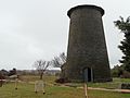 Geldmacher's windmill tower at Nimmitabel
 -
 The concrete elephant “George” at the Nimmitabel Bakery
 -
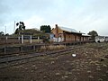 Nimmitabel railway station 21 years after the last train


References
[edit]- ^ Australian Bureau of Statistics (28 June 2022). "Nimmitabel (urban centre and locality)". Australian Census 2021.
- ^ a b Australian Bureau of Statistics (28 June 2022). "Nimmitabel". 2021 Census QuickStats. Retrieved 2 May 2024.
- ^ "Pioneer hall Nimmitabel, new 'access' ramp that only makes the access worse". YouTube. 19 August 2024. Retrieved 14 May 2025.
- ^ "Nimmitabel". Geographical Names Register (GNR) of NSW. Geographical Names Board of New South Wales. Retrieved 7 November 2009.
- ^ "NIMMITABEL – Our historic village – Welcome to the community website for the village of Nimmitabel, New South Wales". Retrieved 7 September 2019.
- ^ "America's Best, Britain's Finest: A Survey of Mixed Movies" - Google Books, John Howard Reid, pub. Lulu.com, March 2006. ISBN 9781411678774, p.241
- ^ KG McQueen "The Tertiary Geology And Geomorphology Of The Monaro: The Perspective In 1994" [1] Centre For Australian Regolith Studies, Canberra 1994
- ^ "Back Roads: S10 Nimmitabel, NSW".
External links
[edit] Nimmitabel travel guide from Wikivoyage
 Media related to Nimmitabel, New South Wales at Wikimedia Commons
- Aerial photo of Nimmitabel from Terraserver[permanent dead link]
- Information about Nimmitabel, including history and photos
- Some history from Peter Goed, particular focus on the 1950s
- Article: "The Day the Stars Came to Nimmitabel..The Making of the Sundowners" by Peter Goed @ Cooma-Monaro website (includes photos from the making of the film in 1959)
Nimmitabel
View on GrokipediaEtymology and History
Etymology
The name Nimmitabel originates from the Ngarigo language, spoken by the Aboriginal people of the Monaro region in southeastern New South Wales, where it translates to "the place where many waters start or divide."[4] This meaning reflects the town's location at a watershed on the Great Dividing Range, where streams diverge toward different river systems.[9] Early European records show numerous variations in the spelling of the name, reflecting phonetic interpretations by settlers and surveyors. One of the earliest appearances was as Nimmytabell in 1837 documentation, followed by forms such as Nimity Belle in the 1840s and Nimoitebool used locally around 1840.[10] By 1845, the spelling Nimmitabel was officially adopted on surveyor Charles Townsend's map of the area.[11] Other variants persisted in records, including Nimithybale and Nimmitybelle, highlighting the challenges of transcribing Indigenous words into English.[4] The modern standardized spelling of Nimmitabel solidified in official usage during the mid-19th century, particularly with the establishment of key institutions. In 1858, the post office and church records formally adopted Nimmitabel, marking its persistence as the definitive name despite earlier inconsistencies.[12] This evolution underscores the transition from fluid, localized Aboriginal nomenclature to a fixed colonial designation.[4]Historical Development
The village of Nimmitabel began to take shape in the late 1830s as European settlement expanded into the Monaro region of New South Wales, with the first recorded settlers arriving by 1839 to establish grazing properties along key stock routes.[9] By 1840, locals had begun referring to the emerging settlement as Nimoitebool, reflecting its position at a vital crossroads for travelers heading to the coast, Bombala, and Cooma.[4] The name Nimmitabel first appeared on official maps in 1845, drawn by surveyor Charles Townsend, marking the site's growing recognition as a strategic stopping point for overland drovers and settlers.[13] The discovery of gold at nearby Kiandra in the late 1850s triggered a significant influx of prospectors and laborers passing through Nimmitabel, boosting local commerce and accelerating the village's development despite no major finds in the immediate area.[14] Throughout the mid- to late 19th century, Nimmitabel solidified its status as a regional hub with the construction of essential infrastructure. A stone Catholic church, St. Andrew's, was erected starting in 1856 and opened for services around 1858, serving as one of the area's earliest places of worship.[13] That same year, the village was officially proclaimed, and a post office was established to facilitate communication for the growing population of graziers and travelers.[9] Commercial activity expanded with the opening of Bell's Store in 1861, followed by Cameron's Store in 1866, providing vital supplies to residents and passing traffic.[4] A dedicated courthouse was built in 1863, separate from the local police station established a decade earlier, to handle legal proceedings in the district.[9] In 1865, German immigrant John Geldmacher began constructing a prominent stone windmill tower—completed by 1872—which initially ground flour before being repurposed as a timber mill, becoming a local landmark despite early complaints about its sails startling horses.[15] Education followed suit with the opening of Nimmitabel Public School in 1869, replacing earlier private and Catholic schooling options to meet the needs of settler families.[16] The 20th century brought further connectivity and cultural moments to Nimmitabel, though not without eventual decline in some sectors. The Bombala railway line reached the town in April 1912, extending from Cooma and serving as a terminus until further construction in 1921, which facilitated the transport of wool, timber, and passengers.[17] That year also saw the establishment of the area's first major sawmill, capitalizing on local timber resources and supporting economic growth amid the railway's expansion.[9] In 1959, Nimmitabel gained brief international attention when it served as a key filming location for the Warner Bros. production The Sundowners, with scenes shot in the main street featuring stars like Deborah Kerr and Robert Mitchum, temporarily swelling the local population with crew and extras.[18] The railway, once a lifeline, closed on March 26, 1986, as part of broader cutbacks in rural New South Wales lines, impacting freight and passenger services to the region.[19] In recent years, Nimmitabel has seen community-driven efforts to preserve and highlight its heritage, including projects around the iconic Nimmity Bell—a large brass bell made in 1920 and installed in 2015 as a tourist draw, which faced local disputes and a safety incident where it fell on a resident but was later reinstated. Featured in media coverage in 2024, these initiatives, tied to events like the Steampunk at Altitude Festival, reflect ongoing attempts to revive the town's historical appeal amid modern challenges.[20]Geography and Climate
Geography
Nimmitabel is situated at coordinates 36°30′S 149°17′E within the Snowy Monaro Regional Council local government area in southeastern New South Wales, Australia. The town lies approximately 37 km south of Cooma, 75 km west-northwest of Bega, and 435 km south-southwest of Sydney, positioning it as a key point in the Monaro region's inland landscape.[21][22][23][10] At an elevation of 1,075 m above sea level, Nimmitabel occupies the southern extent of the Great Dividing Range, where the terrain transitions into the expansive, gently undulating Monaro Plains characterized by broad, open grasslands and low hills. This topography reflects the broader southeastern Australian tablelands, with the town's setting contributing to its role as a transitional zone between coastal influences and alpine environments. The elevation and rolling plains provide a stable base for local landforms, with minimal dissection evident in the surrounding basalt-derived landscapes.[10][24][5][25] The region's soils are dominated by unique chernozem, a deep, fertile black soil rich in humus and organic matter, which supports robust agricultural productivity and distinguishes the area as home to Australia's only true chernozem deposits. This soil type arises from the decomposition of grassland vegetation over volcanic parent materials, enhancing moisture retention and nutrient availability. Nimmitabel's location near significant water divides—where precipitation separates to feed northern and southern river systems, including the Snowy River—underpins its Aboriginal name, derived from a local language term meaning "the place where waters divide or start."[26][25][24] Strategically positioned at the intersection of the Snowy Mountains Highway and the Monaro Highway, Nimmitabel functions as a vital gateway to the Snowy Mountains, facilitating access to alpine areas and connecting the Monaro tablelands with coastal and highland routes. These highways traverse the town's central area, underscoring its importance in the regional transport network amid the plains' open vistas.[27][28]Climate
Nimmitabel features an oceanic climate classified as Cfb under the Köppen-Geiger system, marked by cool to mild summers, cold winters, and relatively even precipitation distribution year-round.[29] Long-term records from the Nimmitabel Wastewater Treatment Facility (1911–1975) show a mean annual maximum temperature of 15.6°C and a mean minimum of 3.4°C, with the highest recorded maximum reaching 38.3°C in February and the lowest minimum -10.5°C in August.[30][31] These figures, based on 56 years of data, underscore the temperate yet variable conditions, though they predate recent observations and may not fully capture modern extremes. Precipitation totals average 685.3 mm annually, spread across approximately 81.8 rainy days (≥1 mm), supporting consistent moisture without pronounced dry seasons.[30] Snowfall typically occurs from May to October in this highland area, with about 102.2 clear days per year recorded in shorter-term data (1965–1975).[30][32] The town's elevation of around 1,075 m amplifies cooler temperatures and frost frequency compared to surrounding lowlands, with frosts common from autumn through spring.[33] Post-1975 trends in the broader Snowy Mountains region reveal decreasing snowfall depths and shorter snow seasons, driven by rising temperatures and shifts toward rain over snow, necessitating updated monitoring for local impacts.[34]Demographics and Community
Demographics
At the 2021 Australian census, Nimmitabel recorded a population of 324 residents.[35] This figure represents a slight increase from 320 in the 2016 census, indicating a stable rural population with minimal annual growth of approximately 0.25%.[36] The age structure reflects an ageing community, with the predominant single age group being 70–74 years (10.6% of the population). Significant portions also fall within the 60–69 years range (65–69 years: 8.7%; 60–64 years: 7.8%), and the median age stands at 49 years.[35] Family composition consists of 78 families, of which 46.2% are couples without children, highlighting a prevalence of childless couples; the average number of children in families with children is 2.0. Household size averages 2.1 persons, with two-person households being common in this structure.[35] Religiously, Christianity is the dominant affiliation at 62.8% of the population (the largest broad group, excluding not stated responses).[35] Aboriginal and Torres Strait Islander people comprise 3.4% of residents.[35] The population exhibits low ethnic diversity, with 86.1% born in Australia and 76.4% having both parents born in Australia; approximately 7.8% have both parents born overseas.[35]Community Life
Nimmitabel falls under the governance of the Snowy Monaro Regional Council, which oversees local services such as waste management, road maintenance, and community facilities across the region, including the provision of essential infrastructure for the town's residents.[37] The council ensures coordinated support for small rural communities like Nimmitabel, facilitating access to regional programs while addressing local needs through elected representatives, including a councillor from the town itself.[38] Education in Nimmitabel is anchored by Nimmitabel Public School, established in 1869 as one of the area's earliest educational institutions, serving students from kindergarten to year 6 with a focus on inclusive, co-designed learning programs tailored to individual needs.[16] As of 2024, the school had an enrollment of 11 students, supported by qualified staff offering subjects across the curriculum, including swimming lessons and wellbeing initiatives to foster personal development in a small-group setting.[39] Healthcare access is provided through the local Community Health Centre on Clarke Street, offering primary care services, while residents also utilize regional facilities in nearby Cooma and Bombala for specialized needs; community centers, such as the historic Nimmitabel Community Centre (built in 1913 and formerly a bush nursing home) and the recently renovated Pioneers Hall, serve as hubs for gatherings and support services.[40][41][42][43] The community's social fabric reflects a tight-knit rural ethos, where residents emphasize hospitality and volunteerism to sustain daily life and mutual support, with organizations like the Nimmitabel Men's Shed enabling multi-role participation in woodworking, skill-sharing, and social activities funded by community grants.[44][45] In this small population of 324 (as per the 2021 census; no updated estimates available as of 2025), adaptations to rural living include residents taking on versatile roles across volunteer groups and local initiatives, strengthening bonds through shared responsibilities. A notable recent social highlight was the ongoing saga of the Nimmity Bell, a 1.8-tonne bronze landmark proposed by the local Lions Club to symbolize community renewal; in 2020, volunteer Howard Charles suffered severe injuries, including the loss of a leg, when the bell fell during relocation, yet the project persisted through community determination, culminating in its installation and ringing in 2021 as a beacon of resilience.[46][47] The story gained renewed attention in 2024 via an ABC Back Roads episode, underscoring the drama and ultimate resolution that highlighted the town's collaborative spirit.[48]Economy and Tourism
Economy
The economy of Nimmitabel is predominantly driven by agriculture, with sheep and cattle farming forming the backbone of local production on the region's basalt-derived soils, which support grazing activities across the Monaro plains. These fertile Dermosols enable fine wool production and livestock rearing, contributing to the broader Snowy Monaro area's agricultural output, where the sector accounts for a significant portion of rural land use. Remnants of the historical forestry industry persist from the 1921 opening of the area's first sawmill, though timber milling has largely declined, leaving a legacy of sustainable wood resource management in the surrounding landscapes.[49][50][9] Employment in Nimmitabel centers on small-scale services and support roles tied to regional tourism, including cafes, general stores, and local trades that cater to both residents and passersby. Key businesses include the historic Cameron's Store, established in 1866, and the Nimmitabel Bakery, founded over 60 years ago, which continue to serve as vital community hubs. These operations, alongside trades like mechanics and farm supplies, integrate into the Snowy Monaro economy, where tourism generated $798.8 million in total sales as of 2023/24 and provides indirect employment opportunities through visitor-related services.[51][52][53] The closure of the Nimmitabel railway in 1986 accelerated rural decline by reducing transport links and freight options for farmers, leading to population shifts and economic pressures in the small town. In response, diversification efforts have emphasized eco-tourism, leveraging the area's natural environment for sustainable ventures that complement agriculture. Despite these challenges, the region maintains low unemployment rates, though many jobs remain seasonal, particularly those linked to tourism peaks in winter and summer.[54][49]Tourism and Attractions
Nimmitabel serves as a charming stopover for travelers along the Snowy Mountains Highway, drawing visitors with its historic sites that reflect the town's 19th-century settlement heritage.[55] The Nimmitabel Heritage Walk offers a self-guided tour of key landmarks, including the 1863 courthouse, which was constructed as a dedicated judicial building amid the region's rapid settlement.[56] Other notable structures along the walk include the circa 1872 Geldmacher's Mill (construction began 1865) for milling local grains, and early stores such as Bell's Store from 1861 and Cameron's Store from 1866, both exemplifying the town's commercial growth during the 1860s.[56][57] These sites, many featuring locally made bricks and preserved facades, can be explored in about an hour, providing insight into Nimmitabel's role as a bustling hub on the Great Dividing Range.[55] The town's natural attractions enhance its appeal as a base for outdoor pursuits, particularly due to its proximity to the Snowy Mountains, just 38 kilometers north via Cooma.[24] At an elevation of 1,070 metres, Nimmitabel offers panoramic views across the high-country plains and serves as an ideal starting point for hiking trails and fishing in nearby rivers and lakes, such as Lake Williams, where visitors can enjoy scenic walks and angling amid the rugged terrain of the Great Dividing Range.[58][59] The area's crisp climate supports year-round activities, with summer bringing wildflower blooms and cooler temperatures for exploration, while the surrounding national parks provide opportunities for more extended treks into the Snowy Mountains' alpine environments.[1] Tourism in Nimmitabel is bolstered by convenient amenities and its reputation as one of Australia's highest towns, fostering a quaint rural charm that attracts an annual influx of visitors during the ski season as a gateway to the resorts.[2] Local cafes like the Nimmitabel Bakery, renowned for its handmade pies and seasonal baked goods, and the Sundowner Cafe at the Royal Arms, offering light meals with a focus on regional produce, provide refreshing stops for highway travelers.[60][61] Accommodation options, including the historic Royal Arms B&B, cater to those seeking an overnight stay amid the town's welcoming community atmosphere, emphasizing Nimmitabel's position as a serene highland retreat.[62]Culture and Events
Popular Culture
Nimmitabel has garnered attention in Australian film through its role as a location for the 1960 production The Sundowners, directed by Fred Zinnemann and starring [Deborah Kerr](/page/Deborah Kerr) and Robert Mitchum. Exteriors for the film, which depicts a nomadic Australian family in the 1920s outback, were shot in Nimmitabel and nearby areas in New South Wales during 1959, capturing the region's rugged landscapes to enhance the story's authenticity.[63][64] In recent television, the town received national exposure in the October 22, 2024, episode of ABC's Back Roads, hosted by Heather Ewart. The segment explored Nimmitabel's resilience as one of Australia's highest-altitude towns, focusing on dramatic local stories such as the saga surrounding the historic town bell and profiles of colorful residents who embody the community's spirit.[65][66] While Nimmitabel lacks prominent mentions in major Australian literature, it features contextually in rural narratives of the Monaro region, including local histories like Nimmitabel: The Story of a Town and Its People by Frank Ireland, which chronicles the area's pioneering tales.[67] The town's name also appears in early variations, such as "Nimitybelle," in Banjo Paterson's poem "Those Names," evoking the harsh yet enduring Australian bush life.[68] These media portrayals have elevated Nimmitabel's cultural profile, contributing to increased tourism by drawing visitors interested in its cinematic and televisual heritage, with ABC research indicating significant boosts in visitor numbers following Back Roads features.[69]Local Events
Nimmitabel's cultural calendar is marked by several recurring festivals and community gatherings that highlight the town's creative spirit and historical charm. The Steampunk @ Altitude Festival, held annually on the first weekend of May, such as 3–4 May 2025, celebrates the fusion of Victorian-era aesthetics with imaginative technology through elaborate costumes, artisan markets, immersive theatrical experiences, and live entertainment.[70][71] This volunteer-organized event transforms the town's historic streets into a steampunk wonderland, attracting enthusiasts from across Australia to participate in themed workshops and performances.[72] Another highlight is the Great Divide Folk Festival, a free three-day event occurring every fourth weekend in October, including 24–26 October 2025, at the Federal Hotel in Nimmitabel.[73][74] Hosted by the Nimmitabel School of Arts, it features acoustic folk music performances, dance sessions, poetry readings, storytelling circles, and hands-on workshops like ukulele for beginners, with options for camping to extend the communal atmosphere.[75][76] In addition to these flagship festivals, Nimmitabel hosts regular community markets, such as the Country Women's Association (CWA) markets every second Saturday from September to June at the Pioneers Memorial Hall, where locals and visitors browse handmade crafts, fresh produce, and baked goods in a volunteer-driven setting that emphasizes creativity and regional arts.[77] The town also features the self-guided Nimmitabel Heritage Walk, which explores preserved 19th-century buildings like the Federal Hotel and schoolhouse, along with other historic sites such as the town well and old lock-up, to showcase local history.[24] These gatherings, including the steampunk festival's nods to popular media inspirations, play a vital role in boosting tourism and fostering social connections.[78][75]References
- https://handwiki.org/wiki/Earth:Chernozem