
Community hub
Recent from talks
Contribute something
Nothing was collected or created yet.
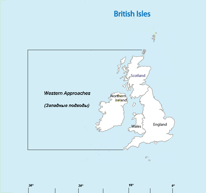
Western Approaches
View on WikipediaThis article has multiple issues. Please help improve it or discuss these issues on the talk page. (Learn how and when to remove these messages)
|

The Western Approaches is an approximately rectangular area of the Atlantic Ocean lying immediately to the west of Ireland and parts of Great Britain. Its north and south boundaries are defined by the corresponding extremities of Britain. The coast of the mainland forms the eastern side and the western boundary is the 30 degree meridian, which passes through Iceland. The area is particularly important to the United Kingdom, because many of its larger shipping ports lie within it.[1]
The term is most commonly used when discussing naval warfare, notably during the Napoleonic Wars, the First World War and the Battle of the Atlantic during the Second World War in which Nazi Germany's Kriegsmarine attempted to blockade the United Kingdom using submarines (U-boats) operating in this area. Since almost all shipping to and from the United Kingdom passed through this area, it was an excellent hunting ground and had to be heavily defended.[2]
See also
[edit]References
[edit]- ^ "Liverpool War Museum, Western Approaches, Battle of the Atlantic, Work War II". 2008-06-25. Archived from the original on 2008-06-25. Retrieved 2023-12-04.
- ^ "Western Approaches in WW2 World Naval Ships Forums Archive". www.worldnavalships.com. Retrieved 2023-12-04.
This article about a specific oceanic location or ocean current is a stub. You can help Wikipedia by expanding it. |