Hubbry Logo
Puerto QuetzalPuerto QuetzalMain
Open search
Puerto Quetzal
Community hub
Puerto Quetzal
logo
8 pages, 0 posts
0 subscribers
Be the first to start a discussion here.
Contribute something
Puerto Quetzal
Puerto Quetzal
from Wikipedia

Puerto Quetzal is Guatemala's largest Pacific Ocean port. It is important for both cargo traffic and as a stop-off point for cruise liners.[2]

Key Information

It is located in Escuintla department, alongside the city of Puerto San José, which it superseded as a port in importance to the country's maritime traffic during the 20th century.
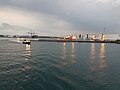
See also

[edit]

References

[edit]
[edit]
Revisions and contributorsEdit on WikipediaRead on Wikipedia
from Grokipedia
Puerto Quetzal is Guatemala's principal deep-water port on the Pacific coast, situated in the Escuintla department approximately 90 kilometers (56 miles) south of . Opened in 1983 following construction that began in 1980, it functions as a critical hub for international maritime , facilitating the of essential goods such as corn, , , and , which account for 47 percent of the nation's inbound cargo. Named after the national bird of , the , the port also supports cruise tourism, serving as a gateway for visitors to nearby cultural sites like the World Heritage-listed city of , located about 90 kilometers (56 miles) inland. The port's development was driven by a national emergency declaration in to address growing maritime demands, with initial operations commencing on , 1983, upon the arrival of the vessel Spiliada, and the first phase of infrastructure completed by November 1985. Operated by the state-owned Empresa Portuaria Quetzal, it features modern terminals, specialized cargo handling, and certifications for security (BASC, 2008), supply chain security (, 2008), occupational health and safety (ISO 18001, 2009), and environmental management (ISO 14001, 2010), positioning it as a key connector to global trade routes along the and the ' West Coast. Economically, Puerto Quetzal plays a pivotal role in 's development by generating revenues that contribute 20 percent of its annual profits to the federal government and 15 percent to the , while fostering investments in expansion projects to enhance capacity and efficiency. In 2025, and the initiated a major expansion project to double the port's capacity through new berths and upgrades, aiming to strengthen regional . Its strategic location amid fertile lowlands has historically supported trade, evolving from a tool for national consolidation in international to a bustling center that bolsters regional employment, , and nearshoring opportunities.

Geography

Location and Setting

Puerto Quetzal is positioned on Guatemala's southern Pacific coast at coordinates 13°55′14″N 90°47′16″W, serving as a key maritime entry point for the country. It falls within the Escuintla Department and the municipality of San José, lying adjacent to the neighboring town of Puerto San José. This strategic placement integrates the port into Guatemala's broader national geography, acting as a vital link between the Central American highlands and international maritime trade routes along the Pacific Ocean. The topography of Puerto Quetzal features a flat that extends inland from the Pacific shoreline, with water depths ranging from 12 to 16 meters near the access channel and up to the turning basin. The surrounding landscape includes fertile lowlands renowned for , supporting crops such as , , and due to the nutrient-rich volcanic soils. On clear days, particularly at dawn, the horizon reveals silhouettes of nearby volcanoes, underscoring the region's position at the interface of coastal plains and the volcanic uplands that dominate 's southern terrain.

Climate

Puerto Quetzal experiences a classified as Aw under the Köppen-Geiger system, characterized by a distinct and consistent warmth influenced by its Pacific coastal location. temperatures range from 25°C to 30°C (77°F to 86°F) year-round, with daytime highs typically reaching 31–33°C (88–92°F) and nighttime lows around 19–24°C (67–75°F), showing minimal seasonal variation due to the equatorial proximity. High humidity prevails throughout the year, often exceeding 70–80%, rendering the air muggy for 88–100% of the time between February and December, which amplifies the perceived heat during the day. Rainfall in Puerto Quetzal follows a bimodal pattern typical of the Pacific slope, with an annual total of 1,000–2,000 mm (40–80 inches) concentrated in the wet season from May to October. During this period, afternoon showers and thunderstorms are common, contributing the majority of precipitation—often exceeding 200 mm (8 inches) per month in peak rainy months like September—driven by moisture from the Pacific Ocean and orographic lift from nearby highlands. The dry season, spanning November to April, brings minimal rainfall, typically under 50 mm (2 inches) per month, with clear skies and lower humidity facilitating outdoor activities but occasionally leading to water scarcity in the region. The climate is occasionally disrupted by tropical storms or hurricanes originating in the eastern Pacific, particularly during the June-to-November season, which can bring heavy rains and strong winds to the coast, as seen with historical events like in 1998. Nearby volcanoes, such as , exert a subtle influence on the local through ash deposition and terrain effects that modify wind patterns and rainfall distribution along the . This volcanic setting supports lush agriculture in the surrounding lowlands via nutrient-rich soils that thrive in the warm, humid conditions, though intense wet-season downpours heighten risks of on slopes and flood-prone areas.

History

Establishment and Early Development

Puerto Quetzal was developed in the late to meet escalating trade demands on Guatemala's , superseding the longstanding port of , which could no longer handle the volume and size of modern vessels amid rising agricultural exports. The port's name derives from the (Pharomachrus mocinno), Guatemala's national bird and a symbol of and national identity. Following a national emergency declaration on November 8, 1979, the Guatemalan government established UNECPA (Unidad Ejecutora del Complejo Portuario en el Litoral Pacífico) to manage the port's construction and development. Actual building work commenced in , led by the French firm Dragages et Travaux Publics, with an initial emphasis on creating facilities for basic cargo loading and unloading. The port initiated operations on March 18, 1983, when the sugar-laden vessel Spiliada docked, underscoring its early role in handling agricultural commodities. UNECPA completed the first construction phase on November 16, 1985, after which the state-owned Empresa Portuaria Quetzal was established to manage port operations, solidifying Puerto Quetzal as Guatemala's key Pacific outlet tailored for exporting primary goods like bananas, , and , thereby enabling larger ships and more efficient flows than predecessor ports.

Modern Expansion and Modernization

In 2017, significant modernization efforts at Puerto Quetzal culminated in the opening of a new terminal operated by on November 24, marking a pivotal upgrade to the port's infrastructure. This $180 million facility, developed as an 85%/15% between and the (IFC) of the World Bank, boosted the port's annual handling capacity to 340,000 TEUs, enabling more efficient operations for routes along Guatemala's Pacific coast. The terminal's advanced equipment and layout improved turnaround times for vessels, positioning Puerto Quetzal as a key gateway for Central American exports. A notable milestone in the port's operational evolution occurred in June 2020 with the arrival of the TUTICORIN, the largest vessel to ever dock in . Measuring 337 meters in length and capable of carrying over 8,000 TEUs, the ship demonstrated the terminal's readiness for mega-container traffic, handling the berthing and cargo operations without incident and underscoring the post-2017 enhancements in draft depth and berth strength. In February 2025, international collaboration drove further expansion, with announcing a $125 million initiative backed by the , including technical oversight from the U.S. Army Corps of Engineers (USACE). The project's initial $63 million phase, focused on feasibility and design, encompasses an 800-meter extension to the terminal, construction of four additional berths, for improved channels, and upgrades to supporting road and energy infrastructure. These developments aim to accommodate vessels exceeding 10,000 TEUs with a 14.5-meter draft, enhancing the port's role in regional logistics. As part of broader U.S. efforts to strengthen economic partnerships in and promote nearshoring opportunities, the expansion supports diversified trade flows and counters geopolitical influences in the region.

Demographics

Population Statistics

Puerto Quetzal, as a key port town in Guatemala's , has an estimated population of approximately 20,000 residents based on recent assessments. This figure positions it as a modest coastal community within the broader , which encompasses over 823,684 inhabitants as of 2023 projections and supports urban expansion through its strategic location along the . Since the port's establishment in the mid-1980s, Puerto Quetzal's population has seen steady growth, largely driven by employment opportunities in port operations, , and related industries, contributing to an overall increase in the local workforce and family settlements. This expansion aligns with departmental trends in , where projections indicate continued urbanization fueled by economic activities, with the municipality of —encompassing the town—reaching about 69,316 residents as of 2023 projections (based on the 2018 census). The town's high population density of 3,300 inhabitants per square kilometer (8,500 per ) underscores its compact layout as a high-density coastal settlement, particularly concentrated around worker communities and supporting . Housing in Puerto Quetzal features dense urban-vivienda expansions, often mixing residential and commercial spaces, with ongoing challenges in ordered development amid -driven influxes; this reflects broader patterns of informal growth in port-adjacent areas within .

Ethnic and Social Composition

The ethnic composition of Puerto Quetzal reflects the broader demographics of Guatemala's department, where the population is predominantly , referred to locally as Ladino. According to the 2018 national census data analyzed for , approximately 94% of residents identify as Ladino, a mixed Amerindian-Spanish heritage group that dominates coastal and urban areas like Puerto Quetzal. This aligns with national trends where Ladinos constitute about 56% of the population, though the proportion is significantly higher in the Pacific lowlands due to historical Spanish and . Indigenous groups maintain a notable but minority presence in Puerto Quetzal, primarily through Maya communities, which account for around 5% of Escuintla's population per the 2018 census. Influences from pre-colonial groups such as the Xinca, an indigenous non-Maya people native to the southeastern Pacific region, persist in small numbers (less than 0.1% department-wide), contributing to local cultural motifs in crafts and traditions. Additionally, tiny communities of (Afro-indigenous) and African-descent individuals (each under 0.2%) add diversity, often linked to historical maritime migrations along the coast. These groups, while not as prominent as in Guatemala's highlands, influence community festivals and artisanal practices. Socially, Puerto Quetzal's is characterized by a working-class centered on port-related labor, with many residents employed in shipping, , and support services. The distribution mirrors the national average, with women comprising approximately 51% of the , though women often face barriers in formal port , leading to higher involvement in informal sectors. Rural-to-urban migration from surrounding agricultural areas sustains the workforce, contributing to social challenges such as informal rates of approximately 80% nationally as of 2023, with likely similar in coastal zones, and limited access to . Culturally, the community embodies a blend of indigenous and Spanish influences, evident in hybrid traditions like coastal festivals combining Maya fishing rituals with Catholic processions. Beyond port activities, strong ties to small-scale fishing and foster community cohesion, with families maintaining plots for crops like and beans alongside marine livelihoods. This syncretic identity underscores the port town's role as a cultural crossroads on Guatemala's .

Economy

Port Operations and Facilities

Puerto Quetzal is managed by the state-owned Empresa Portuaria Quetzal (EPQ), which oversees the overall port administration, while the terminal is operated by under a 25-year agreement. The port features multiple berths dedicated to and cruise operations, including four commercial berths totaling 820 meters in length, a 203-meter berth, and specialized facilities for such as and terminals. The supports vessels up to 13,248 TEU with a maximum draft of 14.5 meters. Operations run 24/7, focusing on the import and export of containers, bulk, and Ro-Ro cargo, with equipment including three Super Post Panamax ship-to-shore cranes, 14 reach stackers, 50 forklifts, and 610 reefer plugs for refrigerated goods. Warehousing and storage span 437,000 square meters outdoors, 5,600 square meters of covered warehouse space, and additional sheds totaling 8,000 square meters, facilitating streamlined movement. The port integrates with regional road networks, providing direct highway access to approximately 100 kilometers away, which supports hinterland connectivity and reduces transit times to about 80 minutes. In terms of capacity and efficiency, the container terminal handles up to 340,000 TEU annually, with recent upgrades allowing for faster turnaround times and full utilization of transpacific vessels. In , overall port throughput reached 6.3 million tons of cargo. Operations are bolstered by modern security features like biometric access and 24/7 surveillance. In May 2025, an agreement was signed with the U.S. Army Corps of Engineers, followed by a mission in September 2025 to advance a $63 million feasibility and design phase for expansion plans to enhance berth capacity and channels.

Trade and Local Industries

Puerto Quetzal serves as Guatemala's primary Pacific port, facilitating the export of key agricultural commodities such as bananas, , , and , which collectively represent a substantial portion of the country's agricultural output shipped internationally. These exports are directed toward major markets including the , , and South American countries, leveraging the port's strategic position near the for efficient trans-Pacific and coastal routing. On the import side, the port handles essential goods like , corn, soybeans, fuels, machinery, and construction materials such as clinker and , supporting domestic industries and consumer needs across and accounting for 47% of the nation's inbound cargo flows. This activity underscores its role in bolstering national , with operations generating 20% of its profits for federal contributions. The 's connectivity to U.S. West Coast ports like and Tacoma further enhances its importance in regional supply chains. Local industries in the surrounding region thrive in tandem with activities, particularly agriculture in the coastal lowlands, where , , and plantations provide raw materials for export cargoes. , including commercial for and as well as renowned billfishing for and , supports both local livelihoods and specialized services. and warehousing sectors have expanded nearby, exemplified by the Zona Libre Quetzal , which handles processing and distribution tied to throughput. These industries collectively generate thousands of direct and indirect jobs in handling, transportation, and related support roles. The port's economic footprint extends to fostering nearshoring opportunities, attracting foreign investment in and to capitalize on its Pacific access and proximity to North American markets. It competes with Atlantic ports like for cargo volumes, particularly in containerized goods and bulk shipments, though capacity constraints at both facilities highlight the need for ongoing expansions to sustain growth.

Tourism

Role as a Cruise Port

Puerto Quetzal serves as a key stopover for traversing Central American itineraries, particularly those featuring the , attracting major operators such as , , , and . The port handles approximately 37 to 50 calls annually, accommodating over 100,000 passengers, with overall receiving 55 to 75 cruise visits per year, the majority directed to this Pacific gateway. This traffic underscores its role in regional cruise circuits, where vessels often dock for day visits en route between North American ports and South American destinations. The port's cruise facilities include a dedicated floating pontoon adjacent to the main terminal, designed to accommodate large vessels with a draft of up to 14.5 meters, allowing direct docking without tendering. This infrastructure, developed in the mid-, features an on-site welcome area with a jade museum, artisan vendor stalls, cafés, and live venues to enhance the passenger experience immediately upon arrival. Shuttle and taxi services are readily available at the terminal for transport to excursion sites, supporting efficient access to nearby attractions. Port deepening and projects since the early have further enabled the handling of larger cruise ships, boosting capacity and operational efficiency. Economically, Puerto Quetzal's cruise operations contribute significantly to seasonal revenue through passenger expenditures on local services, crafts, and tours, aiding post-pandemic recovery in . With its strategic location near routes, the port facilitates increased visitor spending that supports surrounding communities, though specific figures remain integrated into broader national impacts estimated at millions in annual income.

Key Attractions and Excursions

Puerto Quetzal serves as a gateway to several notable local attractions, including the black-sand beaches of Monterrico, located approximately 37 kilometers away and reachable by a 45-minute drive along the . These beaches, formed from , offer visitors opportunities for relaxation and amid dramatic waves. Nearby, the Jade Maya showroom and museum within the Pez Vela cruise terminal provides insights into Guatemala's jade heritage, showcasing artifacts and the mining of fine used by ancient Maya cultures. Popular excursions from the port include day trips to the World Heritage-listed city of , situated about 85 kilometers inland and taking roughly 1 to 1.5 hours by shuttle or bus. In , tourists explore colonial architecture around the central plaza, including the iconic Santa Catalina Arch and the ruins of the Santo Domingo Monastery, which highlight the city's 16th-century Spanish heritage. Another favored outing is a hike up Pacaya Volcano, an active site 2 hours from the port, where guided treks through forests and lava fields lead to viewpoints of the summit at 2,552 meters elevation. plantation tours, often combined with Antigua visits, occur at estates like Finca Filadelfia, about 90 minutes away, where visitors learn about bean cultivation and processing in Guatemala's volcanic highlands. Activities centered on cultural and natural experiences draw many visitors, such as billfishing adventures departing directly from the port's marina, targeting Pacific in the nutrient-rich waters offshore. Cultural tours to nearby Maya weaving communities, like those around or integrated into itineraries, allow participants to observe traditional backstrap techniques and the creation of intricate textiles symbolizing indigenous identity. In Monterrico, seasonal turtle nesting observations from June to December enable guided night walks to witness olive ridley and leatherback turtles laying eggs on the beaches, supporting local conservation efforts. Most attractions and excursions are accessible within 1 to 2 hours by organized bus or shuttle services from the port, with guided options tailored for cruise passengers ensuring timely returns.

Environment

Marine and Coastal Ecology

The coastal zone surrounding Puerto Quetzal encompasses a variety of interconnected ecosystems that contribute to the region's ecological richness. Mangrove forests, estuaries, herbaceous wetlands, and coastal lagoons dominate the landscape, providing critical habitats for nutrient cycling and shoreline stabilization along Guatemala's 250 km Pacific coastline. These systems are particularly prominent in the Escuintla department, where tidal influences and freshwater inflows create dynamic environments supporting detritus-based food webs. Phytoplankton blooms, dominated by diatoms and dinoflagellates, occur annually in nearshore waters such as those off Puerto Quetzal, forming the foundational layer of the marine food chain by fueling primary productivity and sustaining zooplankton, fish, and higher predators. Wildlife in these nearshore and coastal habitats reflects the area's high productivity. Small cetaceans, including the (Tursiops truncatus), (Stenella attenuata), and (Stenella longirostris), frequent the waters around Puerto Quetzal, with bottlenose dolphins comprising the majority of sightings in neritic zones less than 200 m deep. Humpback whales (Megaptera novaeangliae) migrate seasonally through the Eastern Tropical Pacific, utilizing these coastal areas as part of their breeding grounds. Adjacent black-sand beaches, such as those in the nearby Monterrico-Hawaii , serve as key nesting sites for sea turtles, including the olive ridley (Lepidochelys olivacea), leatherback (Dermochelys coriacea), and green turtle (Chelonia mydas), with nesting peaking from August to October. Migratory shorebirds also thrive here, with boreal winter surveys recording over 18,000 individuals across 29 species at 44 sites along the coast; dominant taxa include the western sandpiper (Calidris mauri, 22.5% of totals) and (Charadrius semipalmatus, 11.1%), which rely on estuarine mudflats for foraging during non-breeding seasons. The floral components of Puerto Quetzal's coastal are adapted to the tropical humid , characterized by warm temperatures and seasonal rainfall. Remnant vegetation includes and forests interspersed with open savannas and extensive stands dominated by species such as and , which tolerate saline conditions and periodic inundation. This is enhanced by the fertility of volcanic soils derived from nearby active volcanoes like Fuego and Santa María, which deposit nutrient-rich ash that promotes vigorous plant growth and supports the overall productivity of the . Puerto Quetzal lies within Guatemala's megadiverse Pacific zone, a hotspot of biological diversity where Guatemala as a whole exhibits over 13% endemism in known vertebrate and plant species, with the Pacific zone contributing to broader regional patterns of endemism, underscoring the area's role in Central America's marine biological heritage. These ecosystems host at least 19 cetacean species, contributing to a diverse marine mammal assemblage.

Conservation Challenges

Puerto Quetzal faces significant conservation challenges stemming from expansion activities, which involve and increased runoff that contribute to sediment discharge and coastal . operations for port deepening and extension release sediments into marine environments, potentially smothering benthic habitats and altering in the surrounding Pacific waters. Runoff from facilities and adjacent industrial areas exacerbates contamination through the discharge of pollutants, including and oils, affecting local marine ecosystems. These issues are compounded by plans for ongoing modernization, which necessitate careful to mitigate environmental harm. Overfishing and unsustainable fishing practices in the Pacific coastal waters near Puerto Quetzal deplete and disrupt marine food webs. Artisanal and commercial fisheries often employ methods such as gillnets and that lead to and damage, reducing in the region. Climate change intensifies these pressures, with projections indicating a rise of 1.5°C and increase of 100 mm by 2050 along Guatemala's , leading to , loss, and shifts in species distributions that threaten endemic . Social-environmental overlaps are evident in community concerns raised through formal complaints, such as those filed with the Compliance Advisor Ombudsman (CAO) regarding the impacts of port investments. A 2014 CAO complaint from a local labor union highlighted potential socioeconomic effects of the Empresa Portuaria Quetzal (EPQ) project, including inadequate and risks to community livelihoods from . Agricultural runoff from nearby plantations carries pesticides and fertilizers into coastal zones, polluting waters and harming fisheries that local communities depend on for sustenance. Conservation efforts in the area include robust protection programs in nearby Monterrico, where organizations like operate hatcheries and release initiatives to safeguard nesting sites for species such as the olive ridley turtle. Monitoring of cetacean populations along Guatemala's involves boat-based surveys to assess spatial distribution and abundance of small cetaceans, providing data for habitat protection amid shipping traffic. The 2025 USACE-led modernization project for Puerto Quetzal incorporates environmental reviews as part of international cooperation standards, aiming to integrate mitigation measures for and expansion impacts. As of November 2025, the project remains in the planning phase, incorporating environmental reviews. These local challenges align with broader national issues in , where in upland areas leads to and spillover into coastal marine , accelerating loss. Marine ecosystems suffer from overload causing harmful algal blooms, further straining conservation efforts nationwide.

References

Add your contribution
Related Hubs
Contribute something
User Avatar
No comments yet.