Hubbry Logo
StratumStratumMain
Open search
Stratum
Community hub
Stratum
logo
8 pages, 0 posts
0 subscribers
Be the first to start a discussion here.
Stratum
Stratum
from Wikipedia
Strata in Salta (Argentina)
Goldenville strata in quarry in Bedford, Canada. These are Middle Cambrian marine sediments. This formation covers over half of Nova Scotia and is recorded as being 8,800 m (29,000 ft) thick in some areas.

In geology and related fields, a stratum (pl.: strata) is a layer of rock or sediment characterized by certain lithologic properties or attributes that distinguish it from adjacent layers from which it is separated by visible surfaces known as either bedding surfaces or bedding planes.[1] Prior to the publication of the International Stratigraphic Guide,[1] older publications have defined a stratum as being either equivalent to a single bed or composed of a number of beds; as a layer greater than 1 cm in thickness and constituting a part of a bed; or a general term that includes both bed and lamina.[2] Related terms are substrate and substratum (pl.substrata), a stratum underlying another stratum.

Characteristics

[edit]
The Permian through Jurassic strata in the Colorado Plateau area of southeastern Utah demonstrate the principles of stratigraphy. These strata make up much of the famous prominent rock formations in widely spaced protected areas such as Capitol Reef National Park and Canyonlands National Park. From top to bottom: Rounded tan domes of the Navajo Sandstone, layered red Kayenta Formation, cliff-forming, vertically jointed, red Wingate Sandstone, slope-forming, purplish Chinle Formation, layered, lighter-red Moenkopi Formation, and white, layered Cutler Formation sandstone. Picture from Glen Canyon National Recreation Area, Utah.

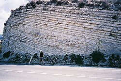
Typically, a stratum is generally one of a number of parallel layers that lie one upon another to form enormous thicknesses of strata.[1] The bedding surfaces (bedding planes) that separate strata represent episodic breaks in deposition associated either with periodic erosion, cessation of deposition, or some combination of the two.[3][4] Stacked together with other strata, individual stratum can form composite stratigraphic units that can extend over hundreds of thousands of square kilometers of the Earth's surface. Individual strata can cover similarly large areas. Strata are typically seen as bands of different colored or differently structured material exposed in cliffs, road cuts, quarries, and river banks. Individual bands may vary in thickness from a few millimeters to several meters or more. A band may represent a specific mode of deposition: river silt, beach sand, coal swamp, sand dune, lava bed, and others.

Types

[edit]

In the study of rock and sediment strata, geologists have recognized a number of different types of strata, including bed, flow, band, and key bed.[1][5] A bed is a single stratum that is lithologically distinguishable from other layers above and below it. In the classification hierarchy of sedimentary lithostratigraphic units, a bed is the smallest formal unit. However, only beds that are distinctive enough to be useful for stratigraphic correlation and geological mapping are customarily given formal names and considered formal lithostratigraphic units. The volcanic equivalent of a bed, a flow, is a discrete extrusive volcanic stratum or body distinguishable by texture, composition, or other objective criteria. As in case of a bed, a flow should only be designated and named as a formal lithostratigraphic unit when it is distinctive, widespread, and useful for stratigraphic correlation. A band is a thin stratum that is distinguishable by a distinctive lithology or color and is useful in correlating strata. Finally, a key bed, also called a marker bed, is a well-defined, easily identifiable stratum or body of strata that has sufficiently distinctive characteristics, such as lithology or fossil content, to be recognized and correlated during geologic field or subsurface mapping.[1][5]

[edit]

See also

[edit]

References

[edit]
[edit]
Revisions and contributorsEdit on WikipediaRead on Wikipedia
from Grokipedia
A stratum (plural: strata; from Latin strātum, meaning "something laid down" or "spread out," the past participle of sternere "to spread") is a distinct layer of material, typically , , or tissue, characterized by relatively uniform composition, texture, or other properties that set it apart from overlying and underlying layers. The term originates in scientific contexts to describe natural layering processes and is fundamental in fields like and for understanding historical and structural developments. In , a stratum represents a or layer of formed by the accumulation and consolidation of in depositional environments, such as rivers, lakes, or oceans. These layers arise from successive depositional events, where variations in sediment type, , content, or —often due to changing environmental conditions like water flow or —create visible boundaries known as stratification planes. Strata can range from thin laminae (less than 1 cm) to thick beds (several meters), and series of related strata form larger units called formations, which are key to geologic mapping and reconstructing Earth's history. Their study, through , reveals past climates, sea levels, and tectonic events; for instance, rhythmic layering indicates seasonal deposition, while within strata points to ancient or current directions. In and , stratum denotes a layer of cells or tissue, most notably in the , the outermost layer, which is divided into five principal strata from deepest to superficial: the (basal layer), , , (present only in thick like palms and soles), and . The process of keratinization drives epidermal renewal, with stem cells in the dividing to produce that migrate upward through the strata over about 30 days, maturing and flattening until they form the protective, dead cell barrier of the . The contains Langerhans cells for immune surveillance. These layers vary in thickness by body region—thickest on friction-exposed areas like soles, thinnest on eyelids—providing barrier functions against pathogens, UV radiation, and dehydration. Beyond natural sciences, stratum appears in statistics as a homogeneous subset of a population used in stratified sampling to improve survey accuracy by reducing variance within groups. In specialized technical contexts, it names protocols or systems, such as the Stratum mining protocol for cryptocurrency pooled mining, which standardizes communication between miners and pools to distribute work efficiently. However, these uses build on the core concept of layered division, underscoring the term's versatility in describing structured hierarchies.

Definition and Context

Definition

A stratum (plural: strata) is a layer of rock, typically sedimentary or , that forms a tabular or lenticular body bounded above and below by distinct surfaces known as planes, and distinguished from adjacent layers by specific lithologic properties such as composition or texture. These layers exhibit relative uniformity in their internal composition, texture, or , arising primarily from depositional processes in sedimentary environments or intrusive emplacement in igneous cases. In geological contexts, strata represent fundamental units in the rock record, serving as the basis for interpreting Earth's history through sequential layering. The term "stratum" derives from the Latin word stratum, meaning "a layer" or "something spread out," the neuter past participle of sternere, "to spread" or "to pave." It was first applied in a geological sense by Nicolaus Steno in his 1669 publication De Solido intra Solidum Naturaliter Contento Dissertationis Prodromus, where he described the as composed of such layered structures to explain origins and rock formation principles. In stratigraphic , a (or stratum) is the fundamental layer bounded by bedding planes, while a formation encompasses a group of contiguous beds (or strata) sharing similar lithologic characteristics and mappable over a geographic area./05%3A_Weathering_Erosion_and_Sedimentary_Rocks/5.04%3A_Sedimentary_Structures) This hierarchy allows for precise correlation and classification of rock sequences without overlapping with broader structural or process-oriented details.

Etymology and Usage

The word stratum originates from Latin strātum, the neuter past participle of the sternere, meaning "to spread out," "to strew," or "to lay flat." This root evokes the image of something spread in a layer, such as a covering or pavement, and the term entered English in the late , around , as a borrowing directly from Latin, initially denoting a horizontal layer or covering. By the , stratum had begun to appear in scientific contexts, particularly in , where Danish anatomist and Nicolaus Steno (1638–1686) employed it to describe layered rock formations in his 1669 work De solido intra solidum naturaliter contento dissertationis prodromus, recognizing strata as deposited in horizontal layers over time. Steno's observations marked an early adoption of the term in , laying foundational principles for without yet formalizing it as a distinct discipline. In the , English geologist William Smith (1769–1839) further entrenched stratum in geological usage through his pioneering work on fossil correlations and stratigraphic mapping, culminating in publications like Strata Identified by Organized Fossils (1816), where he systematically classified British rock layers using the term to denote distinct, identifiable beds. This period saw stratum evolve from a general descriptor of any layered material to a precise geological concept, especially after 1800, as scientific literature increasingly applied it to sedimentary sequences in the context of uniformitarian principles and . Beyond geology, stratum retains its connotation of layered structure across disciplines. In , it refers to social strata, hierarchical divisions of society based on class, status, or economic position, a usage popularized in the by thinkers like and to analyze inequality. In anatomy, terms like describe the outermost, keratinized layer of the , functioning as a protective barrier, with the phrase derived from Latin to emphasize its horny, layered composition. Linguistics employs stratum for historical layers of language influenced by contact, as in substrate or superstrate effects, a concept formalized by scholars like Graziadio Isaia Ascoli in the late . Similarly, in statistics, divides populations into homogeneous subgroups (strata) for more accurate , a method emerging in the 1920s as documented in early statistical journals. These applications highlight stratum's versatility while preserving its core imagery of sequential, superimposed layers.

Formation Processes

Sedimentation Mechanisms

Sedimentation mechanisms refer to the primary processes by which loose particles, dissolved ions, or organic materials accumulate to form the initial layers of strata in sedimentary basins. These processes are governed by the interplay of physical, chemical, and biological factors, resulting in distinct depositional patterns that establish the foundational layering before any subsequent alterations. Physical deposition dominates clastic sedimentation, where gravity-driven of eroded rock fragments occurs in response to decreasing in transport media such as or . In fluvial environments, high-energy river flows transport coarse gravels and sands, depositing them as they slow in lower-gradient reaches, while finer silts and clays settle in quieter overbank areas or lakes. Wind-blown processes in arid settings, like dunes, produce well-sorted layers through eolian transport, often forming large-scale that records prevailing directions. In marine basins, flows deliver mixed sediments to deep-sea fans, creating graded beds from coarse to fine particles as flow wanes. Chemical precipitation forms strata through the and of minerals from aqueous solutions, typically in restricted or evaporative settings. Evaporites, such as and , accumulate in saline lakes or shallow marine lagoons where arid climates promote water , concentrating dissolved ions until sequential occurs—first , then , and finally as seawater volume reduces to about 10%. This process is prevalent in lacustrine and marine basins under low-energy, high-salinity conditions. Biogenic accumulation involves the buildup of organic remains or exoskeletons produced by living organisms, creating layered deposits rich in biochemical precipitates. In tropical marine environments, coral reefs construct massive carbonate platforms through the secretion of skeletons, with associated fine-grained sediments settling in adjacent lagoons to form shell beds or . Similarly, accumulations of planktonic shells in open oceans contribute to widespread layers, while plant debris in humid, swampy fluvial basins forms that layers into seams. These processes thrive in stable, nutrient-rich settings with moderate energy levels. Environmental factors exert strong controls on these mechanisms, determining sediment type, thickness, and layering. Water energy levels dictate distribution: high-energy coastal or riverine zones favor coarse clastics, whereas low-energy deep marine or lacustrine settings deposit fines like muds and shales. influences deposition rates and composition—arid conditions enhance formation in closed basins, while humid climates promote biogenic and fine clastic accumulation in expansive fluvial or deltaic systems. Basin type further modulates these effects; fluvial basins yield irregular, channelized layers from riverine transport, marine basins produce broad, uniform sheets via oceanic currents, and lacustrine basins trap seasonal inputs for rhythmic stratification. Cyclic deposition exemplifies rhythmic layering driven by periodic environmental changes, as seen in varves—annual couplets in glacial lakes formed by seasonal fluctuations. During summer, coarse layers deposit from high-energy inflows, while winter freezing halts input, allowing fine clay to settle in still waters, creating alternating light-dark bands that record yearly cycles in proglacial lacustrine basins. Initial layering arises from the differential settling of particles during deposition, producing uniform that may exhibit internal structures like from migratory currents in rivers or winds. These inclined layers within a reflect migrating dunes or ripples, preserving flow dynamics before the stack consolidates into coherent strata.

Diagenesis and Lithification

Diagenesis encompasses the suite of physical, chemical, and biological alterations that sediments undergo after deposition and before significant , ultimately leading to , the consolidation of loose sediments into coherent rock strata. This transformation is essential for the formation of sedimentary strata, as it imparts durability and structural integrity to the layers. Diagenetic evolution is commonly divided into three sequential stages based on burial depth and environmental conditions: eogenesis, mesogenesis, and telogenesis. Eogenesis occurs in shallow settings near the surface, where sediments experience initial mechanical compaction and early diagenetic reactions driven by meteoric or connate waters, often resulting in minor cementation or biogenic alterations. Mesogenesis takes place at greater depths, typically beyond 1-2 km, under elevated temperatures (around 50-150°C) and , promoting chemical processes such as dissolution, of authigenic minerals, and pressure solution along grain contacts. Telogenesis ensues during uplift and exposure to surface conditions, involving renewed interactions with oxidizing fluids that can cause decementation, fracturing, or of previously stabilized sediments. Key lithification processes drive the solidification of sediments into strata during these stages. Compaction reduces intergranular —often from over 70% in unconsolidated sediments to less than 30%—through the mechanical rearrangement and deformation of grains under increasing . Cementation follows or accompanies compaction, as dissolved minerals such as , silica ( overgrowths), or iron oxides precipitate from pore fluids to bind grains, enhancing cohesion; for instance, cement can form early in eogenesis via or CO₂ . Recrystallization involves the textural reorganization of minerals, such as the conversion of unstable or high-Mg to stable low-Mg or dolomite, which typically intensifies in mesogenesis under thermal influence. Several interrelated factors govern the progression and intensity of diagenesis and lithification. Temperature gradients, rising with burial depth at approximately 20-30°C per kilometer, accelerate reaction kinetics and favor mineral transformations like quartz solubility. Pressure, both lithostatic and fluid-induced, influences compaction rates and can generate overpressures that inhibit full dewatering in rapidly deposited sediments. Fluid migration, including groundwater flow through aquifers or hydrocarbon expulsion, supplies reactive ions for cementation—e.g., silica-rich fluids promoting chert formation—or facilitates dissolution, profoundly shaping the diagenetic pathway. These processes yield profound changes in sediment character, forming the basis of stratified rock units. Original depositional textures, such as delicate , may be obliterated by grain repacking and overgrowths, while secondary porosity develops through selective dissolution of framework grains or cements during mesogenesis or telogenesis, potentially enhancing permeability in strata. Fractures can also emerge from tectonic stresses or shrinkage, creating conduits for later fluid flow and influencing the structural integrity of the resulting stratum.

Physical and Structural Characteristics

Lithologic Properties

The lithologic properties of a stratum encompass its mineral composition, texture, internal structures, and pore characteristics, which collectively define its material identity and environmental origins. Sedimentary strata primarily consist of clastic grains derived from weathered rocks, chemical precipitates, or organic remains, with varying by rock type; for instance, sandstones are dominated by (often comprising 65% or more), along with lesser amounts of and clay minerals, while limestones are chiefly composed of minerals like (CaCO₃) from biogenic or chemical sources. Clastic strata feature detrital grains such as , , or rock fragments, chemical strata include precipitates like evaporites (e.g., or ), and organic strata incorporate biogenic material such as shell fragments or coalified plant debris. Texture in a stratum refers to the size, shape, and arrangement of its grains, providing insights into and deposition dynamics. Grain size follows the Wentworth scale, ranging from clay (<0.004 mm) and silt (0.004–0.0625 mm) in fine-grained strata like shales, to sand (0.0625–2 mm) in sandstones, and gravel or boulders (>2 mm, up to >256 mm) in conglomerates. Sorting describes the uniformity of grain sizes, with well-sorted examples in aeolian dune strata (due to selective ) contrasting poorly sorted glacial (reflecting diverse particle entrainment by ). Roundness indicates abrasion during , yielding angular grains in proximal alluvial deposits (short-distance movement) versus well-rounded grains in beach sands (prolonged wave action). Internal structures within a stratum reveal depositional processes and are to its lithologic fabric. Common bedding types include horizontal bedding, formed by steady suspension settling in low-energy settings like lakes; , produced by migrating dunes or ripples in fluvial or aeolian environments; and , where grains coarsen or fine upward due to waning currents in deep-marine settings. Fossils and trace fossils, such as burrows or footprints, often preserve within these structures, signaling specific environments like shallow marine bioturbation or terrestrial trackways. Porosity and permeability govern a stratum's capacity to store and transmit fluids, influenced by its textural attributes and post-depositional alterations like (detailed in and ). Primary arises from intergranular spaces between grains, prominent in well-sorted sandstones where it can exceed 20–30%, facilitating high permeability for fluid flow. Secondary develops via fractures or dissolution, common in carbonates, enhancing permeability in otherwise tight strata but varying widely (e.g., 2–5% in fractured rocks). These properties underpin applications in resource extraction, as seen in permeable aquifers or reservoirs.

Geometry and Boundaries

Strata exhibit a variety of three-dimensional geometries that reflect the depositional environments and processes responsible for their formation. Tabular geometries are characterized by flat, extensive layers that maintain relatively uniform thickness over large areas, commonly observed in fine-grained deposits such as shales formed in low-energy settings like deep marine basins or floodplains. In contrast, lenticular geometries appear as wedge-shaped or lens-like bodies that thicken in one direction and pinch out laterally, typical of channel sands in fluvial or deltaic systems where sediment is confined to specific pathways. Thickness varies widely, from millimeters for thin beds in laminated sequences to tens of meters for individual units, while larger stratigraphic packages like formations can reach kilometer-scale extents in sedimentary basins. The boundaries between strata serve as critical interfaces that record depositional continuity or interruptions. Conformable boundaries occur where layers are parallel and deposited without significant or hiatus, preserving a continuous stratigraphic record as seen in steady marine or lacustrine successions. Unconformable boundaries indicate periods of non-deposition or , including angular unconformities where underlying strata are tilted or folded relative to overlying horizontal layers, and disconformities where parallel strata overlie an erosional surface, both signaling temporal gaps in the rock record. Transitional boundaries are gradational, marked by progressive changes in over a vertical interval, such as mixed or continuous shifts in or composition, often resulting from gradual environmental transitions. Lateral variations within strata arise primarily from facies changes, where sediment composition and texture shift horizontally due to evolving depositional conditions, as exemplified by shoreline progradation where coarse sands grade into finer muds seaward. These variations follow principles like Walther's Law, which posits that vertically stacked facies correspond to laterally adjacent ones on ancient depositional surfaces. Stratal geometries and extents operate across scales from local outcrops, where individual beds are traceable over meters, to basin-wide features spanning hundreds of kilometers, with tectonics playing a key role in controlling subsidence, uplift, and sediment routing that dictate overall architecture.

Classification and Types

Compositional Classifications

Strata are primarily classified compositionally based on the dominant and grain constituents, which reflect the materials incorporated during deposition and early alteration. This framework distinguishes clastic strata, formed from fragmented pre-existing rocks; chemical and biochemical strata, derived from mineral precipitation or biogenic accumulation; organic strata, rich in preserved biological remains; and mixed strata, combining multiple components. Such classifications aid in identifying rock types and inferring basic depositional conditions, with detailed schemes like the applied to specific subgroups such as sandstones. Clastic strata, the most abundant type, consist of detrital grains derived from the mechanical breakdown of bedrock, sorted by grain size into categories like conglomerates and breccias (gravel-sized, >2 mm), sandstones (sand-sized, 0.0625–2 mm), and shales or siltstones (clay- or silt-sized, <0.0625 mm). These are further subclassified by compositional maturity, which measures the extent of weathering and sorting: immature arkoses contain >25% feldspar alongside quartz, indicating rapid erosion from granitic sources, while mature quartz arenites are >95% quartz, reflecting prolonged transport and chemical weathering that removes less stable minerals like feldspar and lithics. The Folk classification system for sandstones uses a QFL ternary diagram to quantify framework grains—quartz (Q), feldspar (F), and rock fragments (lithics, L)—plotting percentages to delineate subtypes such as subarkoses (high Q and F) or litharenites (high L), enabling precise petrographic identification. Chemical and biochemical strata form through inorganic precipitation or biologically mediated processes, often in restricted aqueous environments. Limestones, predominantly (CaCO₃), arise from shell fragments or direct precipitation in marine settings, while dolomites substitute magnesium for calcium in the carbonate structure (CaMg(CO₃)₂). Evaporites, such as (CaSO₄·2H₂O) and (NaCl), result from supersaturated brines in arid basins, and cherts comprise microcrystalline silica (SiO₂) from siliceous solutions or accumulation. These types are distinguished by their crystalline textures and lack of detrital grains, with biochemical variants like oolitic limestones showing concentric grain structures. Organic strata accumulate from concentrated biological residues, primarily in low-oxygen settings that preserve material. Coals derive from compressed plant debris, ranging from (low-rank, high moisture) to (high-rank, metamorphosed), with composition dominated by carbon, hydrogen, and oxygen in varying ratios. Oil shales, conversely, contain kerogen-rich admixed with clays and carbonates, capable of yielding hydrocarbons upon heating. These strata are identified by their high volatile content and layered maceral structures under . Mixed strata integrate clastic, chemical, or organic elements, often exhibiting hybrid textures like in , where coarser clastic bases fine upward into finer or clay with minor chemical precipitates. Such compositions, common in deep-water settings, defy simple categorization and require integrated analysis of grain types and matrix to classify, as in siliciclastic-carbonate blending sands with grains.

Genetic Types

Strata are classified genetically based on the depositional environments and processes that form them, which directly influence their composition, , and spatial relationships. These genetic types reflect specific physical, chemical, and biological conditions, such as fluvial currents producing cross-bedded sands or marine flows generating graded turbidites. This emphasizes the linkage between formative settings and resulting rock layers, aiding in the reconstruction of ancient landscapes. Alluvial and fluvial strata form in river-dominated continental environments, where by flowing water creates distinct architectural elements. In alluvial fans, coarse gravels and sands deposit as cone-shaped bodies near mountain fronts, fining outward into sandier . Fluvial channels, particularly in meandering rivers, produce fining-upward sequences with cross-bedded sands in point bars and overbank fines like laminated muds and silts on floodplains. systems, by contrast, yield coarser, sheet-like sandstones with abundant due to frequent channel avulsions. These strata often exhibit channel scours and asymmetric , reflecting high-energy reworking. Marine strata encompass a range of submarine settings, each producing characteristic layering tied to water depth and energy. Shallow shelf environments deposit carbonates on stable platforms, forming lime mudstones and skeletal grainstones through biogenic and low-energy settling. Deep basin strata, such as , result from submarine density flows, creating graded beds with Bouma sequences—alternating coarse sands at the base fining upward into muds—often in fan-shaped lobes. Biogenic reefs build mound-like structures of frame-building organisms, yielding porous limestones with and algal frameworks interspersed with reef flank debris. These marine types display hummocky cross-stratification on shelves and sole marks on bases, indicating wave or flow reworking. Aeolian strata develop in wind-dominated arid settings, primarily desert dunes, where prevailing winds sort and transport sand grains. These deposits feature well-sorted, fine- to medium-grained sands with large-scale cross-bedding, formed by avalanching on dune slipfaces, often reaching heights of tens of meters. Interdune areas add low-angle laminations and possible evaporites from episodic wetting. Sheet sands, widespread in sand seas, show subtle 0°-20° cross-stratification from migrating ripples. The high roundness and uniformity of grains distinguish aeolian strata, with minimal matrix and rare bioturbation due to sparse vegetation and life. Lacustrine and glacial strata arise in standing-water or ice-associated continental basins, capturing seasonal or glacial dynamics. Lacustrine deposits, in lake basins, consist of fine-grained shales with horizontal laminations or varves—annual couplets of coarse summer silts over fine winter clays—reflecting cyclic input. Glacial tillites form unsorted diamicts, mixing clays to boulders in a muddy matrix, deposited directly from melting with faceted clasts and dropstones piercing underlying layers. Glaciolacustrine settings blend these, producing varved silts with -rafted in proglacial lakes. These strata lack sorting and show striations from glacial abrasion, contrasting with the rhythmic layering of non-glacial lakes. Volcaniclastic and igneous strata originate from volcanic activity, either as explosive ejecta or intrusive bodies within sedimentary sequences. Volcaniclastic layers, like ash falls, form widespread, thinly bedded tuffs from airfall of pumice, glass shards, and lithics during eruptions, often preserving delicate grading. These can consolidate into welded tuffs if hot, showing eutaxitic textures from compaction. Igneous sills and dikes intrude as tabular sheets parallel or perpendicular to bedding; sills, concordant with strata, inject magma along planes, cooling into fine-grained layers like basalt, while dikes cut across, forming vertical walls. Such intrusions alter host rocks through contact metamorphism, creating baked margins. Paragenetic sequences in strata illustrate genetic relationships through lateral transitions, as described by Walther's Law. This principle states that vertically successive in a conformable section were originally deposited adjacent laterally in shifting environments, assuming no major hiatuses. For example, fluvial sands grade laterally into marine shelf , mirrored vertically in upward-fining successions. It applies to clastic wedges and carbonate platforms, enabling prediction of subsurface geometry from patterns, though diachronous boundaries may complicate interpretations.

Stratigraphic Role and Significance

Principles of Stratigraphy

The principles of form the foundational framework for interpreting the sequence and relative ages of rock layers, enabling geologists to reconstruct Earth's history from sedimentary records. These principles, primarily developed in the 17th and 18th centuries and formalized during the , rely on observable patterns in undeformed sedimentary sequences to establish chronological order without requiring methods. The principle of superposition states that in an undisturbed sequence of sedimentary rocks, each layer is younger than the one beneath it, as newer sediments accumulate on top of older deposits under the influence of gravity. This concept was first articulated by Danish scientist Nicolaus Steno in 1669, who observed that strata exhibit sequential changes reflecting progressive deposition over time. Complementing this, the principle of original horizontality asserts that layers of sediment are initially deposited in a nearly horizontal orientation due to the leveling effect of water or air, with any subsequent tilting attributed to tectonic forces. Steno also identified the principle of lateral continuity, which posits that sedimentary layers extend laterally in all directions until they thin out, pinch off, or transition into a different facies, reflecting the broad areal extent of depositional environments. Additional principles address relationships between different rock types and features. The principle of indicates that any geological feature, such as a fault or , that cuts across an existing rock layer must be younger than the layer it intersects, as the cutting event occurs after the layer's formation. Similarly, the principle of inclusions holds that rock fragments or clasts embedded within a sedimentary or igneous layer are older than the layer itself, since the enclosing rock must have formed around pre-existing material. The principle of faunal succession, introduced by English engineer William Smith in the late 18th century and widely adopted in the 19th, states that assemblages in sedimentary rocks follow a predictable vertical succession, with specific species appearing and disappearing in a consistent order across different locations, allowing for correlation of strata based on their contained fossils. These principles, originating from Steno's seminal observations in , were expanded and systematized in the through the work of figures like Smith, whose faunal succession enabled the first geological maps of , and later geologists who integrated them into a cohesive stratigraphic methodology. Together, they provide a relative dating system that underpins modern , emphasizing the interpretive power of rock layer relationships to trace environmental and temporal changes.

Paleontological and Geochronologic Importance

Strata serve as critical repositories for fossils, enabling through the identification and correlation of index fossils that characterize specific time intervals. Ammonites, for instance, are prominent index fossils for the period due to their rapid evolutionary rates and widespread pelagic distribution, allowing precise biochronological dating of strata across continents. Trace fossils, such as burrows and tracks, further enhance this record by preserving behavioral evidence of ancient organisms, providing insights into and environmental conditions that complement body fossils in stratigraphic analysis. In , strata facilitate via the law of superposition, which posits that in undisturbed sequences, younger layers overlie older ones, establishing a chronological order without numerical ages. refines this framework using radiometric methods; for example, uranium-lead (U-Pb) dating of crystals in igneous layers interbedded with strata yields precise ages for ancient sedimentary sequences, often with uncertainties below 1%. For more recent strata, radiocarbon (¹⁴C) dating of organic materials determines ages up to approximately 50,000 years, leveraging the decay of isotopes absorbed by living organisms. Stratigraphic correlation across regions relies on distinctive marker beds within strata, such as volcanic ash layers, which provide unique geochemical signatures for matching distant outcrops and ensuring temporal alignment. Paleomagnetic reversals, recorded in iron-bearing minerals aligned with Earth's fluctuating , offer another global correlation tool, as these polarity changes occur rapidly and synchronously worldwide, aiding in linking strata from disparate locations. Strata boundaries often delineate major evolutionary events, including mass extinctions; the Cretaceous-Paleogene (K-Pg) boundary, for example, features a global iridium-rich layer attributed to an asteroid impact, marking the abrupt extinction of approximately 75% of Earth's species, including non-avian dinosaurs. This layer, preserved in clay at the boundary, underscores how strata capture catastrophic transitions in the fossil record, informing models of collapse and recovery. The temporal span of individual strata varies widely, reflecting diverse depositional environments; rapid flood or deposits can form thick layers in hours to days, preserving instantaneous events, whereas deep-sea oozes accumulate at rates of mere millimeters per thousand years due to slow biogenic settling in stable oceanic basins. This range in deposition rates highlights strata's role in reconstructing both abrupt and gradual geological processes.

Applications and Human Relevance

Resource Exploration

In resource exploration, strata play a central in the identification and extraction of hydrocarbons, where organic-rich shales serve as rocks that generate through thermal maturation. Porous sandstones often act as reservoir rocks, providing the storage for migrated hydrocarbons due to their high and permeability. Traps, which prevent further migration, commonly form at unconformities or structural folds, creating stratigraphic or structural configurations that accumulate oil and gas. Seismic , utilizing reflection seismic data to delineate depositional sequences and layer geometries, is a key method for mapping these elements and predicting potential reservoirs. For mineral resources, evaporite strata, such as those composed of and , are exploited for salt production, often through solution mining in thick, laterally extensive beds formed in restricted basins. strata, characterized by high content, provide for manufacturing, with quarrying targeting pure, massive layers to minimize impurities. Placer deposits in ancient fluvial strata, including quartz-pebble conglomerates, host economic concentrations of heavy minerals like , preserved in paleochannel systems where hydraulic sorting concentrated detrital particles. Exploration methods rely on , where logs detect shales by measuring natural radioactivity from , , and , which are enriched in clay-rich layers, aiding in lithologic identification for source rock evaluation. Core sampling extracts physical samples from boreholes to analyze rock properties, , and content directly, providing ground-truth data for calibrating indirect measurements. Three-dimensional modeling integrates these data with seismic interpretations to reconstruct stratum , visualizing continuity and trap volumes for drilling optimization. A prominent case study is the Permian Basin in and , where Upper Permian evaporites from the Ochoan Series form seals overlying reservoirs, trapping hydrocarbons in structural-stratigraphic configurations that have yielded billions of barrels of oil. In the Witwatersrand Basin of , Archean fluvial conglomerates within the Central Rand Group host placer deposits, with seismic methods aiding exploration of these quartz-pebble reefs that account for over 40% of global historical gold production. Challenges in stratum-based exploration include faulting, which can disrupt reservoir connectivity by offsetting layers or creating leakage paths, complicating trap integrity and requiring detailed structural mapping. Overpressured strata, common in rapidly deposited shales, pose drilling risks such as blowouts due to elevated pore pressures exceeding hydrostatic levels, necessitating advanced prediction and mud weight management.

Environmental and Engineering Uses

Geological strata play a crucial role in environmental management by delineating hydrostratigraphic units (HSUs) that influence and contaminant migration. , which analyzes the depositional architecture of strata, enables the identification of permeable and impermeable aquitards, such as clay layers that act as barriers to prevent cross-contamination between water-bearing zones. For instance, in contaminated sites, this approach refines conceptual site models (CSMs) by mapping preferential flow paths in fluvial or alluvial deposits, allowing environmental scientists to predict how pollutants like volatile organic compounds (VOCs) or spread. In protection efforts, stratigraphic analysis has been used to evaluate connectivity, such as in the Gulf Coast systems where reconstructing stratigraphic layers helps model recharge and discharge zones to sustain amid . In remediation projects, understanding strata facilitates targeted interventions, reducing costs and environmental impact. By correlating borehole data with facies models—patterns of sedimentary deposition—practitioners can optimize well screen placements in high-permeability sands while avoiding low-yield silts, as demonstrated in cases where extraction volumes were cut by up to 75% for cleanup in compartmentalized aquifers. Additionally, stratigraphic frameworks aid in assessing natural processes, where organic-rich strata enhance of contaminants, supporting long-term monitoring rather than aggressive pumping. This method has been applied in glacial settings to explain divergent flows influenced by deposits, informing protective barriers against off-site migration. For engineering applications, strata provide the foundational data for geotechnical , where properties like , , and are derived from stratigraphic units to ensure . Engineering Stratigraphic Units (ESUs) are defined by grouping layers with similar depositional histories and mechanical behaviors, such as overconsolidated clays exhibiting residual shear strengths of 13–17° or basalts with interbed weaknesses prone to slumping. In foundation design for bridges or buildings, back-analysis of load tests on these units determines bearing capacities, preventing excessive settlement in variable strata like or talus deposits that may require deeper pilings. Strata analysis is essential for and excavation stability in civil projects, where identifying weak layers—such as fractured siltstones or liquefiable sands—guides like drainage systems or . In , stratigraphic mapping assesses seepage risks through permeable horizons, using in-situ tests like standard penetration (SPT) to quantify friction angles (e.g., 28–32° in river sands) for safe embankment placement. For tunneling in urban areas, understanding stratigraphic transitions helps predict ground support needs, as seen in projects navigating mixed marine basalts and mélanges where chaotic layering demands robust exploration to avoid collapses.

References

Add your contribution
Related Hubs
User Avatar
No comments yet.