Hubbry Logo
Shebelle RiverShebelle RiverMain
Open search
Shebelle River
Community hub
Shebelle River
logo
8 pages, 0 posts
0 subscribers
Be the first to start a discussion here.
Shebelle River
Shebelle River
from Wikipedia
Shebelle River
Shabelle
An aerial view of the River Shabelle, Somalia and surrounding farmlands in Hirshabelle State, in a photo taken on 27 November 2022. ATMIS Photo / Raymond Baguma
Shebelle River in Hirshabelle State
Map of the Jubba/Shebelle drainage basin
Map
Native name
Location
Countries
Physical characteristics
SourceEthiopian Highlands
 • locationRobe Gerjeda, Ethiopia
 • coordinates7°13′12″N 39°27′59″E / 7.2201°N 39.4665°E / 7.2201; 39.4665
 • elevation2,326 m (7,631 ft)
MouthJubba River (occasionally)
 • location
Jamame, Somalia
 • coordinates
0°09′57″N 42°46′22″E / 0.1659°N 42.7727°E / 0.1659; 42.7727
 • elevation
14 m (46 ft)
Length2,064 km (1,283 mi)[1]
Basin size298,253 km2 (115,156 sq mi)[1]
Discharge 
 • locationMouth[1]
 • average71.2 m3/s (2,510 cu ft/s)
 • minimum15.7 m3/s (550 cu ft/s)
 • maximum158.7 m3/s (5,600 cu ft/s)
Basin features
ProgressionJubbaSomali Sea
River systemJubba River
CitiesBeledweyne, Jowhar
Population13,900,000[2]
Tributaries 
 • leftErer, Fafen
WaterbodiesMelka Wakena Reservoir

The Shebelle River (Oromo: Laga Shabeellee, Somali: Webi Shabeelle, Amharic: እደላ, Italian: fiume Uebi Scebeli) also known historically as the Nile of Mogadishu,[3][4][5] begins in the highlands of Ethiopia, and then flows southeast into Somalia towards Mogadishu. Near Mogadishu, it turns sharply southwest, where it follows the coast. Below Mogadishu, the river becomes seasonal. During most years, the river dries up near the mouth of the Jubba River, while in seasons of heavy rainfall, the river actually reaches the Jubba and thus the ocean.

During periods of heavy rainfall in Ethiopia, the Shebelle River and the Jubba River merge, and their combined waters ultimately reach the Indian Ocean. However, in drier years, the Shebelle River diminishes and transforms into a series of wetlands and sandy plains to the northeast of the confluence with the Jubba. The Shebelle River has a total length of 1,820 km. The area surrounding the Shebeli River is inhabited by Arsi Oromo people, Somali people in the Somali Region of Ethiopia and Somali people in Somalia. In the lower basin of the river, agriculture has largely replaced the traditional nomadic herding lifestyle, and the cultivation of bananas along the southern stretches of the Shebeli and Jubba rivers contributes significantly to Somalia's export industry.[6]

Tributaries

[edit]

The Shebelle has a number of tributaries, both seasonal and permanent rivers. They include:

The Fafen only reaches the Shebelle in times of heavy rainfall; its stream usually ends before reaching the main river.

History

[edit]

Ajuran Empire

[edit]

During the middle ages, the Shebelle river was under the control of the Ajuran Empire and was largely utilized for its plantations. Coming into prominence during the 13th century AD, the Ajuran monopolized the water resources of the Jubba and Shebelle Rivers. Through hydraulic engineering, they also constructed many of the limestone wells and cisterns of the state many of which are still in use today. Its rulers developed new systems for agriculture and taxation, which continued to be used in parts of the Horn of Africa as late as the 19th century.[7]

Through their control of the region's wells, the Garen rulers effectively held a monopoly over their nomadic subjects as they were the only hydraulic empire in Africa during their reign. Large wells made out of limestone were constructed throughout the state, which attracted Somali and Oromo nomads with their livestock. The centralized regulations of the wells made it easier for the nomads to settle disputes by taking their queries to government officials who would act as mediators. Long-distance caravan trade, a long-time practice in the Horn of Africa, continued unchanged in Ajuran times. Today, numerous ruined and abandoned towns throughout the interior of Somalia and the Horn of Africa are evidence of a once-booming inland trade network dating from the medieval period.[8]

With the centralized supervision of the Ajuran, farms in Afgooye, Bardhere and other areas in the Jubba and Shabelle rivers increased their productivity. A system of irrigation ditches known locally as Kelliyo fed directly from the Shebelle River and Jubba rivers into the plantations where sorghum, maize, beans, grain and cotton were grown during the gu (Spring in Somali) and xagaa (Summer in Somali) seasons of the Somali calendar. This irrigation system was supported by numerous dikes and dams. To determine the average size of a farm, a land measurement system was also invented with moos, taraab and guldeed being the terms used.

The urban centers of Mogadishu, Merca, Barawa, Kismayo and Hobyo and other respective ports became profitable trade outlets for commodities originating from the interior of the state. The Somali farming communities of the hinterland from Jubba and Shebelle rivers brought their crops to the Somali coastal cities, where they were sold to local merchants who maintained a lucrative foreign commerce with ships sailing to and coming from Arabia, Persia, India, Venice, Egypt, Portugal, and as far away as Java and China.[9]

Modern period

[edit]

According to Thomas Wakefield, who visited the region, the river was also known as the "Adari River".[10] The source of the Shebelle River is cultivated by the Arsi Oromo, Sidamo and mostly Somalis, respectively. It is surrounded by a sacred enclosure wooded with juniper trees, which as of 1951 was under the protection of a Muslim member of the Arsi.[11]

In 1989, with the help of Soviet engineers, the Melka Wakena dam was built on the upper reaches of the Shebelle River in the Bale Mountains. Producing 153 megawatts, this dam is Ethiopia’s largest hydroelectric generator.[12]

The recent history of the Shabelle is marked by frequent destructive flash floods. The Shabelle is said to have flooded every other year prior to the 1960s; that decade had only two devastating floods, the hidigsayley in 1965, and the soogudud in 1966. In the 1970s, the most devastating flood was the kabahay of 1978.[13] In 1996, floods devastated three woredas in Ethiopia. On 23 October 1999, the river unexpectedly flooded in the middle of the night, destroying homes and crops in 14 out of the 117 kebeles in Kelafo woreda, as well as 29 of the 46 kebeles in neighboring Mustahil woreda. According to the local authorities, 34 people and an estimated 750 livestock died, with 70,000 affected by the floods and in need of assistance.[14] Two more recent floods were the dawdle in 2003, when about 100 livestock and 119 people were washed away, and the flood of April 2005, when about 30,000 persons were surrounded by floodwaters and 2,000 camels and 4,000 shoats were washed away by the floods; some locals consider this the worst flood in 40 years.[13]
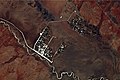
See also

[edit]

Notes

[edit]
[edit]
Revisions and contributorsEdit on WikipediaRead on Wikipedia
from Grokipedia
The Shebelle River is a perennial waterway originating in the Ethiopian Highlands, where it gathers the bulk of its discharge from highland rainfall, before flowing southeast across the Ethiopia-Somalia border into southern Somalia's arid lowlands, sustaining irrigation-dependent agriculture and pastoralism for millions despite typically dissipating into coastal swamps or sands without reaching the Indian Ocean. The river's course supports fertile floodplains and canal systems that enable cultivation of crops including sorghum and maize, as well as grazing for cattle, sheep, goats, and camels, forming the economic backbone of riverine communities in an environment otherwise limited by low precipitation. Its hydrology features biannual overflows from Ethiopian monsoon rains, fostering flood-recession farming but also generating destructive inundations during extreme events, as evidenced by satellite observations of widespread flooding in the valley during high-flow periods. In years of exceptional volume, the Shebelle may merge with the nearby Jubba River before the sea, though such occurrences remain infrequent amid variable upstream contributions that dominate its flow regime.

Geography

Course and Length

The Shebelle River originates in the Bale Mountains of the Ethiopian Highlands at an elevation of 4,230 meters above sea level. It flows southeast through upper, middle, and lower valleys in Ethiopia, covering a distance of approximately 1,290 kilometers to the border with Somalia. Entering Somalia near Belet Weyne, the river traverses gently sloping, semi-arid plains southward, parallel to but inland from the Indian Ocean coastline due to a coastal ridge. Within Somalia, it spans about 1,236 kilometers before dissipating into swamps and marshes near Balcad, lacking a permanent mouth to the sea. During exceptional high flows from heavy Ethiopian rains, it merges with the Jubba River, allowing some water to reach the Indian Ocean. The total length of the main course is thus around 2,526 kilometers.

River Basin

The Shebelle River basin encompasses a drainage area of approximately 297,000 km², with about two-thirds located in Ethiopia and the remainder in Somalia. The Ethiopian portion, covering roughly 202,000 km², lies primarily in the Oromia and Somali regions, featuring rugged highlands with elevations exceeding 4,000 meters that generate over 90% of the river's flow. In Somalia, the basin extends across 108,000 km² in the central and southern regions, including Hirshabelle and South West states, characterized by flat, arid lowlands below 500 meters elevation prone to seasonal flooding. Basin morphology includes steep upper catchments conducive to rapid runoff and , transitioning to meandering channels in the lower plains that facilitate infiltration and evaporation losses. is predominantly semi-arid and grassland, with rain-fed agriculture in the and intensive schemes along the Somali valley supporting crops like , , and fruits. dominates upland areas, where has contributed to degradation, while densities are higher in fertile riparian zones, sustaining millions dependent on the river for livelihoods. The basin's transboundary underscores challenges, with controlling upstream sources and relying on downstream flows for and urban in areas like Beletweyne and . variability, including erratic rainfall averaging 300-800 annually in lowlands, exacerbates vulnerabilities to and , influencing basin-wide availability.

Tributaries

The Shebelle River, known as Wabi Shebelle in its upper Ethiopian course, receives inflows primarily from left-bank tributaries originating in the Ethiopian highlands, which sustain its perennial character upstream of the Somali border. These tributaries drain the southeastern escarpment and contribute the majority of baseflow through consistent seasonal precipitation in the Bale Mountains region. The most significant tributary is the Fafen River (alternatively spelled Fanfan or Fafan), an intermittent stream rising east of Harar in eastern Ethiopia's sedimentary lowlands. It flows southeastward and merges with the Shebelle during episodes of heavy rainfall, typically in the wet seasons (Gu and Deyr), thereby boosting downstream discharge and flood volumes; in dry periods, the Fafen largely dissipates before confluence. This tributary's catchment adds substantial episodic sediment and water volume, influencing the Shebelle's hydrological regime across the Ogaden Plateau. Smaller permanent and seasonal streams from the Ethiopian side, such as those in the upper Wabi sub-basin, provide steady contributions but lack individually dominant flows; in Somalia, arid conditions limit major additions, with only minor wadi-like inflows during rains. Overall, Ethiopian tributaries account for over 80% of the basin's upstream water yield, underscoring the river's transboundary dependence on highland hydrology.

Hydrology

Flow Regime and Discharge

The Shabelle River exhibits a bimodal flow regime, characterized by two annual peak discharge periods corresponding to the primary rainy seasons in its Ethiopian headwaters: the Gu (April–June) and Deyr (October–December), with the latter often generating the highest flows due to more intense and prolonged precipitation. These peaks result from over 90% of the river's flow originating from catchments outside Somalia, primarily in Ethiopia's highlands, where monsoon-influenced rains drive rapid runoff into the main channel. Intervening dry periods, aligned with the Jilaal (January–March) and Xagaa (July–September) seasons, feature low or negligible flows, exacerbated by high evapotranspiration rates exceeding 2,000 mm annually in the Somali lowlands. In its upper and middle reaches through Ethiopia and into central Somalia, the river remains largely perennial, sustaining baseflows from groundwater contributions and residual highland runoff. However, downstream of Belet Weyne toward the coast, the regime shifts to intermittent, with the channel frequently ceasing to flow during dry months (January–May) due to progressive losses from evaporation, infiltration into sandy alluvial soils, and unregulated abstractions for irrigation. This results in a closed basin for most years, where nearly all water is consumed internally via evapotranspiration and human use, with outflow to the Indian Ocean occurring only in exceptionally wet years like 1997 or 2006. Average annual discharge at the Belet Weyne gauging station (catchment area approximately 207,000 km²) measures 75 m³/s, corresponding to a total volume of about 2.4 billion cubic meters (BCM), based on long-term hydrometric records from 1930s–1980s and sporadic post-1991 measurements. Flows decline markedly downstream: at Bulo Burti, annual volumes are roughly 20–30% lower, and at Afgooye near the mouth, they can drop to under 10 m³/s during dry seasons, reflecting cumulative losses estimated at 50–70% of incoming volume. Peak discharges during flood events can exceed 400–500 m³/s at upstream stations like Belet Weyne, driving inundations that extend tens of kilometers laterally, as observed in NASA satellite imagery from major floods in 2005.
Gauging StationAverage Annual Discharge (m³/s)Annual Volume (BCM)Notes on Variability
Belet Weyne752.4Bimodal peaks; baseflow ~10–20 m³/s in dry months
Bulo Burti~50–60~1.6–1.920–30% reduction; intermittent downstream influence
Afgooye<20 (dry season)<0.6Often dry Jan–May; flood peaks up to 100+ m³/s
Data gaps persist due to civil conflict disrupting monitoring since the 1990s, with reliance on pre-war records and remote sensing for recent estimates; observed trends indicate slight declines in mean flows amid variable climate patterns, though without statistical significance in short post-2000 series.

Seasonal Variations

The Shebelle River experiences marked seasonal fluctuations in discharge, driven predominantly by bimodal rainfall patterns in the Ethiopian highlands, which contribute over 90% of its flow. Peak flows typically occur during the Gu season (April to June), corresponding to the short rains (Belg) and early long rains (Kiremt) in Ethiopia, with secondary peaks during the Deyr season (October to December) from residual monsoon influences. These periods align with Somalia's rainy seasons, leading to flood risks along the middle and lower reaches, where discharges can exceed 1,000 cubic meters per second at stations like Belet Weyne during exceptional events. In contrast, dry seasons—Jilaal (January to March) and Hagaa (July to September)—feature critically low flows, with the river often ceasing entirely in its lower Somali sections due to intense evapotranspiration, seepage into sandy aquifers, and upstream abstractions for agriculture. Mean monthly discharges at downstream gauges, such as those near the Ethiopia-Somalia border, drop to near zero in January-February, reflecting minimal highland runoff and high basin losses estimated at 50-70% of inflow through evaporation and infiltration. This intermittency renders the river a closed basin in most years, preventing outflow to the Indian Ocean except during anomalous wet periods. These variations are compounded by high intra-annual coefficients of variation exceeding 100% at key stations, underscoring the river's vulnerability to short-term climatic shifts and human interventions like unregulated diversions, which exacerbate low-flow deficits. Historical data from gauges indicate average annual volumes around 3.5 billion cubic meters at mid-basin sites, but seasonal peaks can represent 40-50% of this total, while dry periods contribute less than 10%.

Water Infrastructure and Management

The Shebelle River's water infrastructure is underdeveloped and largely deteriorated, consisting mainly of barrages and irrigation diversion structures in downstream Somalia. Approximately 10 barrages exist along the combined Juba and Shebelle rivers, designed to increase water depth for irrigation intake and flood control. Pre-civil war irrigation systems supported about 50,000 hectares of full-control irrigation across the Juba-Shebelle basin, but conflict since 1991 has led to widespread abandonment and decay of canals, pumps, and gates due to sabotage, lack of maintenance, and recurrent floods. Efforts to restore these assets, such as spate irrigation covering 150,000 hectares, remain limited by insecurity and funding shortages. Upstream in , which generates over 90% of the river's flow, infrastructure development focuses on hydropower dams and large irrigation expansions outlined in basin master plans. Proposed projects, including dams with capacities to store significant volumes for power generation up to several hundred megawatts, aim to irrigate tens of thousands of hectares but risk depleting downstream supplies by harnessing nearly all available runoff. These unilateral initiatives, lacking benefit-sharing mechanisms, have raised concerns among Somali stakeholders about reduced seasonal flows critical for and ecosystems. Transboundary management is constrained by the absence of binding agreements between Ethiopia and Somalia, despite the river's perennial nature and shared basin spanning multiple countries. Political instability in Somalia further impedes coordinated monitoring, data sharing, and joint infrastructure planning, amplifying vulnerabilities to droughts and floods. In February 2025, Somalia initiated steps toward acceding to the UN Water Convention to bolster governance frameworks for transboundary rivers like the Shebelle, potentially enabling cooperative protocols for equitable allocation and conflict mitigation.

Ecology and Environment

Biodiversity and Ecosystems

The riparian ecosystems along the Shebelle River consist of gallery forests, bushlands, and grasslands that form linear oases in the surrounding semi-arid Ethiopian highlands and Somali plains, supporting vegetation adapted to seasonal flooding and drought. Key woody species include Acacia bussei, Acacia seyal, and Acacia nilotica, which stabilize banks and provide shade, while floodplains host herbaceous layers with wild cotton relatives (Gossypium spp.) and small tangled bushes. These zones act as wildlife refuges and avian migration corridors, contrasting with adjacent arid scrub dominated by drought-tolerant acacias. Aquatic biodiversity centers on endemic fish species in the Shebelle-Juba ecoregion, such as Bagrus urostigma (a catfish), Labeo boulengeri and Labeo bottegi (cyprinids), and Synodontis geledensis (upside-down catfish), alongside Nilotic species like those from Lake Abaya excluding Hyperopisus bebe. Subterranean limestone aquifers linked to the river harbor blind, depigmented cavefish including Uegitglanis zammaranoi and Phreatichthys andruzzii, adapted to dark, oxygen-poor waters. Downstream swamps and wetlands, fed by low flows, sustain invertebrate communities and groundwater recharge, though data on macroinvertebrates remains sparse. Terrestrial fauna in riparian areas includes birds like the African fish-eagle (Icthyophaga rüppellii), which preys on riverine fish, and regional species such as the Kenya violet-backed sunbird (Anthreptes orientalis) in adjacent scrub. Mammals are underdocumented but likely encompass browsers like dik-dik and oribi in bushlands, with riparian corridors facilitating movement for larger species including Somali wild ass (Equus africanus somaliensis). Reptiles, potentially including agamas and skinks, exploit the moist microhabitats, though comprehensive surveys are limited. Historical floodplain forests, once more extensive, have been largely cleared for agriculture, reducing habitat connectivity and endemic plant diversity, as noted in assessments of Somali biodiversity hotspots. Current ecosystems thus reflect fragmented riparian strips amid agricultural expansion, with conservation data gaps persisting due to regional instability.

Environmental Challenges and Degradation

Deforestation across the Shebelle River basin, driven by illegal logging, agricultural expansion, and overgrazing, has intensified soil erosion and sediment transport into the river. In the upstream Wabi Shebelle sub-basins in Ethiopia, land use changes such as conversion of forests and grasslands to cropland have elevated soil erosion rates, with studies identifying high-risk areas in sub-watersheds like the Erer and Dawe Rivers. This erosion contributes to heavy siltation, raising the riverbed and reducing channel capacity, which has been identified as a primary factor in the increased frequency and severity of floods over recent decades. Water pollution in the Shebelle River stems largely from untreated urban waste, agricultural runoff, and inadequate sanitation, choking sections of the waterway with debris and contaminants. Flood events further exacerbate this by spreading pollutants to groundwater sources and farmlands, as observed in community reports from flood-prone districts like Belet Weyne, where silting and bank erosion compound water quality decline. Livestock watering and irrigation demands also degrade quality through nutrient loading and salinity buildup in downstream reaches. Climate change amplifies these degradation processes by altering hydrological patterns, leading to more erratic flows with prolonged droughts interspersed by intense floods in the Shebelle valley. For instance, projections indicate reduced minimum flows due to higher evapotranspiration and variable rainfall, while upstream sediment increases from degraded lands heighten downstream flood risks, as evidenced by severe inundations in 2023 affecting riverine communities. Overall land degradation, including desertification in Somali portions, further diminishes riparian ecosystems and recharge capacity, perpetuating a cycle of environmental vulnerability.

Economic and Human Significance

Irrigation and Agriculture

The Shebelle River provides critical water for in southern , particularly in the Middle and regions, where riverine communities rely on canal systems to cultivate crops amid arid conditions. Primary crops include and , grown on irrigated fields that also support livestock grazing for , sheep, , and camels. Additional cash crops such as , , and have been introduced in rehabilitated areas, diversifying livelihoods beyond subsistence farming. Irrigated along the Shebelle totals approximately 50,000 hectares, though much of the , including barrages, remains dysfunctional to conflict, , and sedimentation, leading to unreliable water distribution. Farmers face challenges from highly variable river flows, which complicate irrigation scheduling and reduce productivity, as the river often fails to reach the sea and dissipates in inland swamps during dry periods. Traditional small-scale draws directly from the river and its fertile floodplains, enabling year-round farming in an otherwise rain-dependent environment. Recent rehabilitation efforts have targeted canal networks to restore productivity; for instance, initiatives aim to repair 246.8 kilometers of canals serving 30,300 hectares, while broader projects cover 350 kilometers along the Shebelle and Juba rivers to enhance sustainable agri-food systems. FAO-supported programs, including the TRANSFORM project launched in 2024, focus on climate-smart agriculture and infrastructure upgrades to bolster food security in riverine zones. These interventions have increased access to reliable water, enabling expanded vegetable production and improved incomes for smallholder farmers in areas like the Middle Shabelle. Despite these advances, agricultural output in the Shebelle Valley remains vulnerable to upstream water diversions in Ethiopia and local environmental degradation, underscoring the need for transboundary management to sustain irrigation-dependent productivity. The river's role extends to supporting export-oriented farming, with riverine areas contributing significantly to Somalia's crop production, though precise yield data is limited by ongoing instability.

Settlements and Water Supply

The Shebelle River sustains key settlements in central Somalia, where riverine communities depend on its flows for domestic water needs, including drinking, sanitation, and livestock watering. Primary towns such as Beletweyne, at the river's entry point into Somalia, and Jowhar serve as administrative and economic hubs, with populations relying on direct abstraction from the river or shallow wells recharged by its infiltration. Beletweyne, estimated to house around 67,200 inhabitants as of 2020, draws much of its urban water supply from the Shebelle via pumps and traditional intakes, though access is hampered by seasonal variability and infrastructure limitations. In Jowhar, further downstream, the river similarly underpins household water provision amid risks from low flows and contamination, with local systems often involving open wells and riverbank extraction vulnerable to drought and flooding. Smaller settlements and villages along the banks, including areas like Bulo Burti and Jalalaqsi, support semi-settled pastoralist groups transitioning to agriculture, where the river's average inflow of 75 cubic meters per second at Beletweyne facilitates basic human and animal consumption requirements. These communities extract water manually or through rudimentary diversion, contributing to localized depletion during dry periods when upstream Ethiopian abstractions reduce availability. Groundwater aquifers nourished by Shebelle seepage extend water access for settlements beyond the immediate riparian zone, sustaining an estimated riverine population integral to south-central Somalia's demographics. Domestic demands, intertwined with irrigation, account for a portion of the basin's total water use, with assessments indicating environmental flows comprising about 35% of the river's volume within Somalia to maintain ecological support for human settlements. Challenges persist due to inadequate treatment facilities, leading to health risks from polluted river water used untreated in many households, exacerbated by conflict disrupting maintenance of supply infrastructure.

Role in Food Security

The Shebelle River contributes significantly to in southern Somalia by facilitating irrigated agriculture along its lower course, where rainfall is insufficient for reliable rainfed cropping. This irrigation supports the cultivation of staple crops including , , and , as well as grazing for such as , sheep, , and camels, thereby sustaining local food production and reducing dependence on imports. The riverine areas, particularly in , function as a key cereal-producing zone, with irrigated schemes enabling output for both domestic consumption and export, despite vulnerabilities to variable flows. Irrigation infrastructure along the Shebelle, including canals and pumps, covers substantial farmland, with rehabilitation projects targeting up to 30,300 hectares through the restoration of 246.8 kilometers of canals, enhancing crop yields and household resilience. Small-scale irrigation initiatives have demonstrated improvements in agricultural productivity, dietary diversity, and income for rural households, countering the effects of recurrent droughts that plague non-irrigated areas. The river's fertile floodplains and water resources underpin Somalia's broader agricultural output in the Shabelle-Juba basin, which accounts for a disproportionate share of national food production relative to the country's arid landscape. However, the river's role is constrained by environmental and infrastructural challenges, including upstream diversions in Ethiopia, degraded canals, and flood-drought cycles, which periodically disrupt farming and exacerbate food insecurity for millions dependent on these systems. Efforts by organizations like the FAO to rehabilitate infrastructure and promote climate-resilient practices aim to bolster this capacity, as evidenced by expanded irrigated areas post-conflict, though sustained maintenance remains essential for consistent contributions to national food supplies.

History

Pre-Colonial Period

The Shebelle River valley in southern Somalia and eastern Ethiopia has long supported human activity through its seasonal floods and perennial flow in upstream reaches, enabling pastoral nomadism and early flood-recession farming among Cushitic and Somali-speaking groups prior to the medieval period. Archaeological evidence of permanent settlements remains limited due to the region's aridity and erosion, but oral traditions and historical accounts indicate that agro-pastoral communities utilized the river for livestock watering and rudimentary inundation techniques, where seasonal inundations deposited fertile silt for sorghum and millet cultivation without extensive canal systems. From the 13th to 17th centuries, the Ajuran Sultanate established dominance over the Shebelle and Jubba river basins, transforming the valleys into centers of hydraulic engineering and agricultural productivity as a "hydraulic empire" that monopolized water control. The sultanate constructed limestone wells, cisterns, and early irrigation canals along the Shebelle, facilitating intensive farming of crops like bananas, grains, and cotton in fertile alluvial plains, which supported major trading towns such as those near modern-day Mogadishu. This infrastructure, including spate irrigation harnessing floodwaters, underpinned the empire's economic reliance on riverine agriculture and export-oriented commerce, with Rahanweyn clans settling along the Shebelle during this era to cultivate flood-dependent fields. By the , pre-colonial developments included the of emancipated Bantu-descended communities in riverine villages like Golweyn and Bulo Mererta, where freedmen from earlier slave imports established self-sustaining farms using traditional and small-scale diversions from the Shebelle. These settlements, inhabited by groups such as the Shiidle, practiced and , though vulnerable to droughts and inter-clan raids, reflecting a shift toward more sedentary exploitation of the river's resources amid growing trade with the . Overall, pre-colonial reliance on the Shebelle emphasized adaptive, low-tech suited to the river's variable flow, contrasting with later mechanized systems.

Colonial Era

During the late 19th and early 20th centuries, Italian colonial authorities in prioritized the Shabelle River valley for agricultural expansion due to its reliable seasonal water flow, which supported irrigation-dependent farming. Initial efforts focused on exporting as Somalia's first colonial , alongside and later bananas, with plantations concentrated in the region between the Shabelle and Jubba rivers. By the and , under Fascist Italy's intensified settlement policies, over 100 plantations were established in the Shabelle and Jubba valleys, granting large landholdings to Italian settlers and introducing forced labor regulations that compelled local Somali and Bantu populations into agricultural work. Irrigation infrastructure, including an extensive network of canals, was developed during this period to enable year-round cultivation, transforming the riverine areas into productive zones for banana exports that gained privileged access to Italian and Mediterranean markets. These initiatives marked the Shabelle as a core economic asset of Italian Somaliland, though they often involved suppressing local resistance, such as razing villages east of the river during military campaigns against Somali clans in the early 1900s. Exploration efforts, including the 1928–1929 expedition led by Luigi Amedeo, Duke of the Abruzzi, mapped the upper Shabelle's sources in the Ethiopian highlands, aiding colonial boundary claims and potential upstream control. British influence remained marginal, confined largely to northern protectorates distant from the Shabelle's course, though post-1941 occupation of Italian Somaliland following World War II temporarily shifted administrative oversight without major alterations to existing river-based agriculture. The valley's plantations sustained export revenues but exacerbated land tenure conflicts and reliance on coerced labor, setting precedents for post-colonial economic dependencies.

Post-Independence Developments

Following Somali independence on , , the Shebelle River emerged as a central hub for national , with emphasis placed on expanding irrigated to boost food production and exports such as bananas and . Large-scale irrigation schemes were initiated along the river's lower and middle reaches, including the of multiple barrages to regulate flow and divert water for cultivation, transforming semi-arid areas into productive farmlands supporting up to 90% of Somalia's irrigated by the late . In the Middle Shebelle region, flood management systems were implemented, channeling excess waters into natural depressions for storage and subsequent irrigation use, which helped mitigate seasonal flooding while enhancing dry-season farming. Under President Siad Barre's regime from 1969 to 1991, state-led initiatives nationalized colonial-era plantations and expanded riverine infrastructure, though inefficiencies and corruption limited sustained gains; pre-civil war irrigation demands in the Shebelle basin alone required approximately 1,500-2,000 million cubic meters of water annually to sustain schemes like those near Mogadishu and Merca. These developments supported a shift from nomadic pastoralism to sedentary farming, with the river enabling cash crop production that accounted for a significant portion of Somalia's GDP in the 1970s and 1980s. The outbreak of the Somali Civil War in 1991 severely disrupted river management, as factional fighting destroyed or abandoned key infrastructure including barrages, canals, and pumping stations along the Shebelle, leading to widespread salinization, siltation, and reduced cultivable land in Lower Shebelle and Middle Shebelle regions. Conflict over riverine territories exacerbated water access disputes among clans and militias, halting maintenance and rehabilitation efforts; by the mid-1990s, production in affected areas had plummeted, contributing to chronic food insecurity despite the river's perennial flow. Persistent instability into the 2000s, including control by groups like Al-Shabaab in river valley districts, further impeded infrastructure recovery, with damaged systems unable to cope with variable flows originating from upstream Ethiopia.

Transboundary Issues

Upstream Developments in Ethiopia

The Wabi Shebelle River, the Ethiopian segment of the Shebelle, originates in the Bale Mountains of the Region at elevations exceeding 3,000 meters and flows southeastward through the semi-arid Plateau, covering approximately 200,000 square kilometers of basin area in before crossing into . Flow volumes average around 2.4 billion cubic meters annually at the border, primarily from highland rainfall between March and May, with minimal contributions from groundwater or Somali tributaries. The principal upstream infrastructure is the Melka Wakena Hydroelectric Power Station, a 153-megawatt facility constructed on the river in the West Arsi Zone of Oromia, with operations commencing in the late 1980s. This run-of-river dam with reservoir storage regulates seasonal discharges for power generation, supplying electricity to the national grid while altering downstream flow patterns through peaking operations that release water variably. Reservoir levels have declined due to reduced inflows from climate-driven precipitation variability, with streamflow projections indicating potential 20-30% decreases under future scenarios. Irrigation development remains limited, confined to small-scale schemes along the river's arid lower reaches in the Ogaden, where canal networks support subsistence farming of crops like maize and sorghum across fewer than 10,000 hectares. Ethiopia's Wabi Shebelle basin master plan identifies irrigation potential exceeding 400,000 hectares, with 141 schemes proposed—including 25 large-scale projects—aiming to divert up to 3,150 million cubic meters annually for agricultural expansion, though implementation has prioritized hydropower over consumptive uses to date. Additional planned infrastructure includes the Kuldash Dam site, surveyed in the 1970s near the Ogaden boundary for multi-purpose regulation, capable of storing over 1 billion cubic meters to enable downstream irrigation and flood control, but remaining unbuilt as of 2025 amid prioritization of other basins. These developments reflect Ethiopia's broader strategy to harness highland runoff for domestic energy and food security, with abstractions projected to intensify flow regulation without formal transboundary agreements.

Interstate Tensions and Disputes

The Shebelle River basin lacks formal water-sharing agreements among Ethiopia, Somalia, and Kenya, fostering interstate tensions primarily between Ethiopia and Somalia over upstream water diversions and their downstream effects. Ethiopia, as the riparian state contributing over 90% of the river's annual flow from highland runoff, has pursued unilateral irrigation and hydroelectric projects, raising Somali concerns about reduced water availability for agriculture in the lower basin, where the river supports 75% of Somalia's GDP through farming and livestock. These developments, including planned dams and abstractions in Ethiopia's Oromia region, have been criticized for potentially exacerbating droughts and food insecurity in Somalia without prior consultation, contravening principles of equitable utilization under international water law. In February 2017, Somalia formally urged Ethiopia to refrain from interfering with the Shebelle's flow, citing violations of international norms on shared watercourses and emphasizing the river's critical role in Somali irrigation and settlements. This followed reports of diminished river levels attributed to Ethiopian upstream extractions, prompting diplomatic protests and highlighting the absence of joint monitoring mechanisms. Ethiopia countered by asserting sovereign rights to develop its resources, but the episode underscored broader hydro-political frictions, with Somalia viewing Ethiopian actions as a form of hydro-hegemony that prioritizes upstream benefits at downstream expense. In May 2017, Ethiopia and Somalia established a bilateral committee to address Shabelle disputes, aiming to oversee flow management and mitigate conflicts through data sharing and coordination. However, progress has been limited, with no binding treaty emerging and tensions persisting amid Ethiopia's expanding agricultural schemes along the river, which could abstract up to 20% of mean annual flow under medium-demand scenarios, severely impacting Somali flood-recession farming. Somali officials and analysts have warned that without cooperative frameworks, such as those under the Intergovernmental Authority on Development (IGAD), these issues risk escalating into resource-based conflicts, particularly as climate variability amplifies flow uncertainty.

Management and Cooperation Efforts

The Shebelle River basin lacks formal bilateral or multilateral agreements for transboundary water management between Ethiopia and Somalia, despite Ethiopia controlling over 60% of the basin area and contributing more than 95% of the river's runoff. Ethiopia has pursued unilateral developments guided by its 2005 Shabelle River Basin Integrated Development Master Plan, which outlines six dams for hydropower generation totaling 1,000 MW and storage of 10,000 million cubic meters (Mm³), alongside 141 irrigation schemes covering 209,310 hectares requiring 2,566 Mm³ annually by 2035; these projects have proceeded without prior notification to downstream Somalia. Regional bodies such as the Intergovernmental Authority on Development (IGAD) have facilitated studies and forums to address shared basin challenges in the Horn of Africa, including hydrologic modeling for the Juba-Shabelle system to inform water resources assessment, though these efforts have not yielded binding cooperation mechanisms specific to the Shebelle. IGAD advocates for integrated water management but notes persistent obstacles, including Somalia's political instability since 1991, which has impeded joint planning. Somalia has sought to bolster transboundary governance through international frameworks, pursuing accession to the United Nations Water Convention as of February 2025 to enhance cooperation on shared rivers like the Shebelle, emphasizing equitable benefit-sharing and data exchange with upstream Ethiopia. Analysts recommend initiating bilateral dialogue for basin-wide planning, such as prioritizing Ethiopian hydropower upstream while reserving irrigation flows for Somalia, potentially linked to economic incentives like Ethiopian access to Somali ports in exchange for flow regulation. These proposals remain unimplemented amid historical tensions and mismatched water demands exceeding available supply.

Recent Developments

Flood Events

The Shebelle River experiences recurrent flooding due to intense seasonal rainfall in the Ethiopian highlands, which swells the river's flow, combined with its low gradient and meandering path through arid Somali lowlands that impede drainage and promote overflows. These events typically peak during the gu (April–June) and deyr (October–December) rainy seasons, inundating riparian zones and exacerbating vulnerabilities in agriculture-dependent communities lacking robust levees or early warning systems. Floods have caused thousands of displacements, hundreds of deaths, and widespread destruction of farmland, livestock, and infrastructure across Hirshabelle and South West states in Somalia, as well as upstream areas in Ethiopia's Somali Region. Significant historical floods struck Beletweyne and surrounding areas in 1961, 1977, 1981, 1997, 2005, 2006, and 2013, with river levels at gauging stations exceeding alert thresholds by factors of 2–3 meters, leading to breaches of natural and rudimentary embankments. In April–May 2005, heavy rains triggered overflows that killed at least 154 people in Ethiopia's Wabi Shebelle basin, destroyed 35 villages, and displaced thousands, with downstream effects visible in of inundated Somali valleys. By 2006, renewed flooding in displaced over 10,000 residents and drowned livestock, compounding recovery challenges from the prior year. In 2013, persistent high water from August onward—stemming from upstream deluges—isolated villages along the lower Shabelle, submerged 20,000 hectares of farmland, and affected 50,000 people in Middle Shabelle, where overflows began in September due to highland runoff. The 2018 floods, among the most severe in recent decades, displaced over 230,000 individuals nationwide, with Shebelle overflows damaging irrigation canals and homes in Beletweyne district, where annual maximum flows at monitoring stations reached peaks not seen since 2006. By 2019, October rains caused severe inundation in Hirshabelle State, impacting 300,000 people and destroying 13,000 hectares of crops, while 2020 deyr floods affected 105,000 in Hirshabelle and adjacent regions, killing dozens and eroding riverbanks. The 2023 floods marked one of the worst episodes, with excessive October–November rainfall in Ethiopian highlands raising Shebelle levels to burst banks near Beletweyne, displacing nearly 250,000 in central Somalia, killing at least 53 confirmed victims, and submerging urban areas under meters of water; regional tolls exceeded 130 deaths across affected East African basins. These events highlight causal factors like upstream precipitation volumes exceeding 200 mm in days—unmitigated by dams—and downstream siltation reducing channel capacity, resulting in repeated cycles of humanitarian crises despite sporadic international aid.

Drought and Water Scarcity

The Shebelle River basin experiences recurrent droughts that exacerbate water scarcity, primarily due to highly variable rainfall patterns and dependence on seasonal flows originating in Ethiopia's highlands. Historical data indicate that the river's average discharge at Belet Weyne station is approximately 75 cubic meters per second, but flows frequently drop below critical thresholds during dry periods, rendering downstream sections seasonal or ephemeral. In the lower reaches, the river often fails to reach the Indian Ocean, evaporating or infiltrating into the soil, which limits perennial water availability for irrigation and domestic use in Somalia's Hirshabelle and South West states. These conditions have historically triggered famines, as seen in the 2011 drought, when reduced river levels contributed to crop failures and livestock deaths across the basin. Drought episodes have led to critically low river levels, with monitoring data showing instances where water depths reached historical minima. For example, in early 2017, upstream levels at key gauging stations fell to unprecedented lows since records began, attributed to consecutive poor Deyr (short) rains in 2015–2017 and heightened agricultural abstractions. Similarly, by March 2016, river levels at multiple sites plummeted to the lowest since 1963, prompting emergency water trucking and borehole reliance in affected communities. Environmental flow requirements, estimated at 23.5 million cubic meters annually to sustain ecosystems, are often unmet during such events, leading to habitat degradation and salinization of alluvial aquifers. The 2020–2023 drought, the longest and most severe in over four decades, intensified along the Shebelle, with five consecutive failed rainy seasons causing river flows to dwindle and displacing over 1 million Somalis by late 2022. This period fueled acute food insecurity, with pastoral and riverine livelihoods in Middle and regions suffering mass livestock losses—estimated at millions of animals—and near-total harvest failures, pushing millions toward thresholds. By August 2025, ongoing dry conditions in central , including Shabelle-adjacent areas, continued to disrupt access to water and pasture, compounding vulnerabilities in urban centers like , where the river's division amplifies exposure to flow variability. Water scarcity in the basin stems from a combination of climatic unreliability, upstream diversions in Ethiopia, and downstream overexploitation for agriculture, which accounts for over 90% of withdrawals. Rising demands from population growth and irrigation expansion threaten to further strain supplies, with projections indicating potential deficits if current trends persist without enhanced storage or efficiency measures. In Somalia's Shabelle-dependent zones, this manifests as chronic shortages for 2–3 million residents reliant on riverine farming, exacerbating conflict over remaining resources amid weak governance.

Climate Change Impacts

Projections for the Shebelle River basin indicate rising temperatures and mixed changes in , with potential increases in annual rainfall up to 9% under certain scenarios, though higher rates may offset gains in water availability. In the upper Wabi Shebelle sub-basin, multimodel ensembles forecast decreased spring and winter rainfall alongside consistent warming trends, leading to altered regimes. These shifts are expected to heighten intra- and inter-annual flow variability, exacerbating existing challenges in a region prone to arid and semiarid conditions. Hydrological modeling in upstream catchments, such as Melka Wakena, suggests that climate change could reduce streamflows during dry periods under representative concentration pathway scenarios, driven by elevated temperatures and changed precipitation timing. Observed increases in extreme events, including floods and droughts, have been linked to climatic variability, with the Shabelle River exhibiting periods of drying due to erratic rainfall patterns. Flood frequency and severity along the river have risen in recent decades, potentially compounded by upstream sediment increases from erosion under warmer, wetter conditions in headwaters. These impacts threaten riparian agriculture and livelihoods, as reduced reliability of river flows—despite stable or slightly increased annual volumes—amplifies water scarcity during critical growing seasons. In southern Somalia, heightened flood risks from intense rainfall events, projected to become more common, have displaced communities and damaged infrastructure, while droughts strain groundwater recharge dependent on river inflows. Empirical records underscore the basin's vulnerability, where historical flow data already show high variability now intensifying under global warming influences.

References

Add your contribution
Related Hubs
User Avatar
No comments yet.