
Community hub
Recent from talks
Contribute something
Nothing was collected or created yet.
Singrauli
View on Wikipedia
Singrauli is a city in Singrauli district in the Indian state of Madhya Pradesh and Commissionaire of Rewa. It lies about 26 kilometres (16 mi) from the district headquarters of Waidhan.
Key Information


History
[edit]Previously, it was a part of Singrauli State which was ruled by the Venvanshi Maharajas. Khairwar (tribe) are native of Singrauli (M.P.) who have been living here for many decades.
Geography
[edit]Singrauli is located on 24°12′07″N 82°39′58″E / 24.202°N 82.666°E. It is at an elevation of 394 m.[2] 486889 is pin code of singrauli.
Demographics
[edit][needs update] As of the 2011 Census of India,[3] Singrauli had a population of 220,257, of which males were 53.1% and females were 46.9%. Child population (0–6) in urban region was 30,079. The average literacy rate in Singrauli was 75.51%.
Administration
[edit]Singrauli Municipal Corporation is the local body governing the city, and is the second richest municipal corporation in Madhya Pradesh.[4] Rani Agrawal is the mayor of the city.[5] Singrauli is in Rewa Division.
Politics
[edit]The city is part of the Singrauli Assembly constituency. Ramniwas Shah is MLA from here. It's part of Sidhi Lok Sabha constituency..[6]
Economy
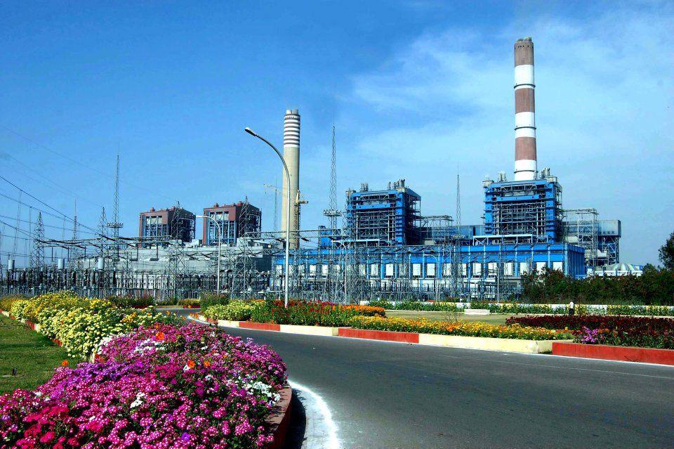
[edit]The economy of Singrauli is mainly related to coal mining and related activities. Singrauli coal region is a big coal producing region. Many thermal plants are also operating here, which makes it the energy source of India. Along with this, an aluminium plant of Hindalco Industries is also located here.[7][8] It is the 2nd largest district for per capita income in Madhya Pradesh.
Major Thermal Power Project and Plants of Singrauli -
Transport
[edit]Singrauli railway station - Here is a railway station located in Singrauli town. Its code is SGRL. The station consists of 3 platforms. Katni Singrauli railway line passing through here, which connects it from Delhi and Bhopal by train.[9]
References
[edit]- ^ a b "Madhya Pradesh (India): State, Major Agglomerations & Cities – Population Statistics, Maps, Charts, Weather and Web Information". citypopulation.de. Retrieved 3 January 2021.
- ^ "Node: Singrauli (1672312676)". 8 December 2023.
- ^ "Census of India: Search Details - Singrauli". Retrieved 11 November 2021.
- ^ Dwary, Anurag. "AAP Makes Madhya Pradesh Debut With Singrauli Mayoral Win". NDTV.com. Retrieved 16 August 2022.
- ^ "AAP Makes Madhya Pradesh Debut With Singrauli Mayoral Win". NDTV.com. 17 July 2022. Retrieved 19 July 2022.
- ^ "Delimitation of Parliamentary and Assembly Constituencies Order, 2008" (PDF). 26 November 2008. Retrieved 24 June 2021.
- ^ "NTPC's Vindyachal plant largest power generating station". The Economic Times. 28 October 2015.
- ^ "Action Plan for critically polluted industrial areas/ clusters – Singrauli - MP" (PDF). MP Pollution Control Board. Retrieved 3 May 2012.
- ^ "SGRL/Singrauli". India Rail Info.
External links
[edit]
This article related to a location in Madhya Pradesh is a stub. You can help Wikipedia by adding missing information. |
Singrauli
View on GrokipediaSingrauli is a district in the eastern part of Madhya Pradesh, India, established as the state's 50th district on 24 May 2008 with its headquarters at Waidhan. Covering an area of 5,675 square kilometers, it had a population of 1,178,273 according to the 2011 census, with a density reflecting its rural and industrial character.[1][2]
The district's economy has transformed from agriculture-dominated to industry-focused following the discovery of vast coal reserves, making it India's "Energy Capital" or Urjanchal, with Northern Coalfields Limited overseeing major mining operations that produced over 51 million tonnes of coal annually in the mid-2010s.[3][1]
It hosts six major thermal power plants generating approximately 21 gigawatts of electricity, supplying a substantial portion—up to 15%—of India's power needs, primarily through coal-fired facilities that support northern grid demands.[4][5]
While this industrial base drives employment and regional development, empirical studies document elevated air and soil pollution levels around these plants and mines, correlating with health risks for local residents despite the district's role in national energy security.[4][6]
Historical Background
Ancient and Medieval Periods
The Singrauli region preserves evidence of human occupation from the Lower Paleolithic era, with lithic artifacts including handaxes, scrapers, and choppers discovered in river valleys such as the Mayar. These findings, exposed through erosion and surveys, span Lower Palaeolithic to Mesolithic phases, suggesting sustained prehistoric settlement amid forested terrain conducive to hunter-gatherer lifestyles.[7] [8] In the early historic period, the area functioned as a trade nexus linking northern and central Indian networks, evidenced by artifact distributions and proximity to ancient routes. Local tradition attributes the name Shringavali—later evolving to Singrauli—to the sage Shringi, a figure invoked in ancient Hindu lore for performing rituals that precipitated rains, though this etymology remains legendary rather than archaeologically corroborated.[8] [9] Transitioning into the early medieval era, rock-cut caves emerged in Mada tehsil around the 7th to 8th centuries AD, showcasing rudimentary monastic and sculptural features. Prominent examples include Vivah Mada, Ganesh Mada, Shankar Mada, Jaljalia, and Ravan Mada, hewn into sandstone cliffs and indicative of Buddhist or early Hindu ascetic practices amid regional political fragmentation. Painted rock shelters nearby further attest to artistic continuity from prehistoric motifs.[10] [11] As part of the broader Baghelkhand tract—historically termed Dahala—Singrauli experienced rule by the Kalachuri dynasty from the 6th to 12th centuries, a warrior lineage centered at strongholds like Kalinjar, which exerted control over eastern Madhya Pradesh through feudal tributaries. By the 9th century, localized principalities emerged, including a purported Singrauli kingdom with capital at Teonthar under Raja Kot Rai, reflecting the era's mosaic of semi-independent rajas navigating Kalachuri overlordship and emerging Baghel clans. Archaeological paucity limits precise attributions, but the caves' dating aligns with Kalachuri cultural patronage of rock architecture.[12] [9]Colonial Era and Early Independence
During the British colonial period, Singrauli constituted a portion of the Rewa princely state, governed by the Baghel Rajput dynasty under British paramountcy via the Baghelkhand Agency. The region's dense forests rendered it suitable as an open-air prison for political detainees, while supporting local communities dependent on forest resources for sustenance. Commercial exploitation intensified as timber from these forests was harvested to meet demands for railway construction and locomotive manufacturing.[13][9] In 1857, amid the broader Indian Rebellion against British rule, British officer Captain Rabthan identified coal deposits and established the area's first open-cast mine at Kotav village, leveraging the Son River for transportation of extracted coal. The Baghelkhand Agency, overseeing Rewa and adjacent territories including Singrauli, merged administratively with the Bundelkhand Agency in 1931, though direct governance remained with Rewa's rulers subject to British oversight.[9][13][9] Upon India's independence in 1947, Rewa—encompassing Singrauli—acceded to the Dominion of India through an instrument signed by Maharaja Martand Singh, ending princely autonomy. The territory integrated into the Union as part of Vindhya Pradesh, formed in 1948 by consolidating Rewa and neighboring former princely states, with Rewa designated as the capital; this union persisted until further reorganization into Madhya Pradesh in 1956.[14][15][9]Industrial Transformation Post-1950s
The industrial development of Singrauli accelerated post-independence as India's energy demands spurred systematic exploitation of its extensive coal reserves, shifting the region from agrarian roots to a focal point for mining and power generation. Although exploratory mining occurred earlier, the post-1950s era saw intensified efforts through public sector initiatives, aligning with national plans for heavy industrialization and self-sufficiency in coal production. By the 1960s and 1970s, geological surveys confirmed vast reserves in the Singrauli Coalfield, prompting infrastructure investments that transformed the landscape into an energy hub.[16] The nationalization of coal mines via the Coal Mines (Nationalisation) Act, 1973, centralized operations under state control, facilitating large-scale open-cast mining suited to Singrauli's geology. This culminated in the establishment of Northern Coalfields Limited (NCL) in November 1985 as a subsidiary of Coal India Limited, headquartered in Singrauli to manage coalfield operations. NCL's formation from portions of existing units enabled efficient extraction, with production ramping up through mechanized methods; by the late 1980s, the region hosted multiple operational mines contributing significantly to national coal supply.[17][18] Concurrently, thermal power development intertwined with mining, exemplified by the National Thermal Power Corporation's (NTPC) founding in 1975 and the commissioning of the Singrauli Super Thermal Power Station in 1977 as India's inaugural pithead facility. With an initial capacity of 2,000 MW across five 200 MW units plus expansions, it leveraged adjacent coal sources for cost-effective generation, powering northern and central grids. Subsequent plants, including those by NTPC and private entities, proliferated in the 1980s–2000s, establishing Singrauli's role in supplying over 10% of India's thermal power by the 2010s, though expansion involved land acquisition challenges.[19] This synergy of mining and power infrastructure generated employment for tens of thousands while driving ancillary industries like transportation and cement production, yet it also intensified environmental pressures from opencast operations and emissions, underscoring trade-offs in resource-led growth.[20]Physical Geography
Location and Topography
Singrauli district lies in the northeastern corner of Madhya Pradesh, India, extending across latitudes approximately 23.8° to 24.7° N and longitudes 81.8° to 82.8° E.[21] Covering an area of 5,672 square kilometers, it shares its northern boundary with Uttar Pradesh along the Son River and adjoins Sidhi district to the south and west.[21] The district headquarters at Waidhan is positioned at roughly 24.20° N, 82.67° E.[22] The topography features undulating terrain with a series of central hill ranges and southern elevations varying between 365 and 488 meters above mean sea level.[21] [23] The general slope inclines northeast toward the Son River, with the highest recorded point near Chitrangi reaching 609 meters.[22] Average elevations across the district hover around 361 meters, reflecting a landscape of plateaus interspersed with valleys.[24] Principal rivers shaping the hydrology include the Son, which flows west to east along the northern edge, and the Rihand, originating within the district and joining the Son after forming the significant Rihand Reservoir.[22] [25] Tributaries such as Gopad, Mahan, and Mayar drain the hilly interiors, often coursing through rocky channels with limited alluvial deposits except near major streams.[26] [23] This riverine network supports the region's groundwater and influences local land use patterns amid the predominantly lateritic and alluvial soils.[23]Climate Patterns and Natural Resources
Singrauli district features a tropical monsoon climate, marked by distinct seasonal variations including hot summers from March to May, a southwest monsoon period from June to September, post-monsoon transition in October and November, and mild winters from December to February. Summer temperatures often surpass 40°C, peaking near 45°C in May, while winter lows dip to around 10°C in January, with average annual temperatures at 25.2°C.[23][27] Precipitation totals approximately 1,096 mm annually, concentrated during the monsoon, with July recording the highest at 317 mm across about 15 rainy days; drier months like April see minimal rainfall under 10 mm. This pattern supports agriculture but contributes to seasonal flooding risks in low-lying areas near rivers. The district's natural resources are dominated by extensive coal deposits in the Singrauli Coalfield, part of the Gondwana supergroup, which underpin large-scale mining operations by entities like Northern Coalfields Limited and fuel thermal power plants. Permian-age coal seams, analyzed for geochemical properties, yield reserves vital to India's energy sector, though extraction has led to environmental pressures including deforestation and water contamination.[28][13] Forests, primarily tropical dry deciduous types, originally covered significant portions but have diminished due to mining; remaining wooded areas harbor biodiversity yet face ongoing threats from coal projects encroaching on 90% forested blocks in some cases. Rivers such as the Son (originating near Amarkantak and flowing northeast), Rihand (dammed into Govind Ballabh Pant Sagar for hydropower and industrial water supply), and Gopad provide surface water resources, while groundwater aquifers in Gondwana sandstones and Archaean granites sustain limited yields, with dynamic resources estimated through geological surveys showing moderate recharge potential amid mining impacts.[23][22][29]Demographic Profile
Population Dynamics and Census Data
According to the 2011 Census of India, Singrauli district had a total population of 1,178,273, comprising 613,637 males and 564,636 females, yielding a sex ratio of 920 females per 1,000 males.[30][31] The district recorded a decadal population growth rate of 28.03% between 2001 and 2011, exceeding the state average for Madhya Pradesh of approximately 20%, attributable in part to influxes of migrant labor drawn by expanding coal mining and thermal power sectors.[30] This growth followed a 38.6% increase from 1991 to 2001, reflecting accelerated industrialization post-1950s that shifted the region from agrarian subsistence to resource extraction hubs.[30] Population density stood at 208 persons per square kilometer in 2011, across the district's 5,675 square kilometers, with rural areas predominating; of the total, about 81% resided in rural settings, while urban centers like Singrauli city accounted for 220,257 inhabitants.[30] Scheduled Tribes constituted 32.6% of the population (383,994 individuals), primarily indigenous groups displaced or employed in mining peripheries, contributing to uneven demographic pressures including seasonal migration and family relocations for industrial jobs.[30] The child sex ratio (0-6 years) was 909, indicative of persistent gender imbalances amid economic transitions.[30] No comprehensive census has occurred since 2011 due to national delays, but provisional estimates project the 2023 population at around 1.51 million, assuming continued annual growth near 2.3% driven by sustained employment in energy sectors rather than natural increase alone.[32] These dynamics underscore Singrauli's transformation into a labor-importing district, with net in-migration offsetting lower rural fertility rates, though official data gaps limit precise quantification of inter-state inflows from labor-surplus regions.[29]Ethnic and Socio-Economic Composition
The ethnic composition of Singrauli district includes a significant indigenous Scheduled Tribe (ST) population of 383,994 persons, representing 32.6% of the total 1,178,273 residents recorded in the 2011 Census.[33] Scheduled Castes (SC) comprise 150,664 individuals, or 12.8% of the population.[33] The balance consists of Other Backward Classes and general category groups, with Hindi spoken by 96.67% of residents and Gondi by 1.64%, indicative of Gond tribal influence.[34] Major tribal communities encompass Baiga, Kol, and Gond groups, historically dependent on forest foraging, shifting cultivation, and small-scale agriculture.[35] Socio-economic indicators reveal persistent disparities, particularly among tribal populations. The district's overall literacy rate is 60.41%, below the national average of 74.04% as of 2011, with male literacy at 71.34% and female at 48.53%.[34] Tribal literacy lags further, constrained by limited school infrastructure in remote areas and cultural factors prioritizing early labor over education.[36] Employment is dominated by the coal sector, with a labour force participation rate of 79.02% in 2023-2024, but indigenous groups often hold low-skill, informal roles amid heavy in-migration of non-local workers for technical positions.[34] Industrial expansion has induced displacement of over 10,000 tribal families since the 1970s, eroding traditional livelihoods through land acquisition and deforestation without commensurate rehabilitation or skill training.[37] This has perpetuated poverty cycles, with tribes facing health hazards from mining pollution—such as respiratory ailments—and restricted access to project benefits, as resource revenues accrue primarily to external corporations and state coffers rather than local reinvestment.[35] Urban-rural divides exacerbate these issues, with 19.25% urban residency correlating to higher incomes in industry but minimal trickle-down to rural tribal hamlets.[33]Governance and Politics
Administrative Framework
Singrauli district operates under the administrative jurisdiction of Madhya Pradesh, forming part of the Rewa Division, with its headquarters at Waidhan.[38] The district was established as the 50th district of the state on 24 May 2008 through the bifurcation of Sidhi district.[39] Governance follows India's three-tier Panchayati Raj system, integrating revenue administration, magisterial functions, and rural development initiatives, overseen by state-appointed officials and elected local bodies. The district administration is led by the Collector and District Magistrate, who serves as the chief executive responsible for law and order, revenue collection, disaster management, and coordination of development schemes.[40] The current Collector is Gaurav Benal, IAS, assisted by an Additional District Magistrate (Pramod Kumar Sengupta), a Joint Collector (Sanjeev Kumar Pandey), and Deputy Collectors.[40] Law enforcement falls under the Superintendent of Police, currently Manish Khatri, IPS, who manages district-wide policing through sub-divisional and tehsil-level stations.[40] Sub-Divisional Magistrates handle executive magistracy in key areas, such as Singrauli (Suresh Jadav) and Deosar (Akhilesh Singh).[40] Revenue administration is structured across eight tehsils—Singrauli Nagar, Singrauli, Chitrangi, Deosar, Mada, Sarai, Dudhmania, and Bargawan—each headed by a Tehsildar tasked with land records, taxation, and dispute resolution.[41] Rural development occurs through three community development blocks (Chitrangi, Deosar, and Waidhan), managed by Block Development Officers who implement schemes like MGNREGA and watershed management.[23] These blocks encompass 316 gram panchayats governing 832 villages, facilitating grassroots governance and service delivery.[1] At the district level, the Zila Panchayat coordinates panchayat-level activities, while urban areas like Singrauli city fall under a municipal council for civic administration.[42]Electoral History and Representation
Singrauli district is represented in the Madhya Pradesh Legislative Assembly by three constituencies: Chitrangi (reserved for Scheduled Tribes, AC 79), Singrauli (general category, AC 80), and Devsar (general category, AC 81). These constituencies form part of the Sidhi Lok Sabha constituency (PC 11), which encompasses Singrauli along with Sidhi and parts of Shahdol districts.[43] In the 2023 Madhya Pradesh Legislative Assembly elections, conducted on November 17, 2023, the Bharatiya Janata Party (BJP) won all three seats with substantial margins, reflecting its continued hold in the region.[44]| Constituency | Winner | Party | Margin of Victory (Votes) |
|---|---|---|---|
| Chitrangi | Radha Ravindra Singh | BJP | 59,879 over INC candidate Manik Singh[45][46] |
| Singrauli | Ramniwas Shah | BJP | 37,977 over INC candidate Renu Shah[47][48] |
| Devsar | Rajendra Meshram | BJP | 22,454 over INC candidate Bansmani Prasad Verma[49][50] |