Hubbry Logo
SurkotadaSurkotadaMain
Open search
Surkotada
Community hub
Surkotada
logo
8 pages, 0 posts
0 subscribers
Be the first to start a discussion here.
Contribute something
Surkotada
Surkotada
from Wikipedia

Map showing Surkotada

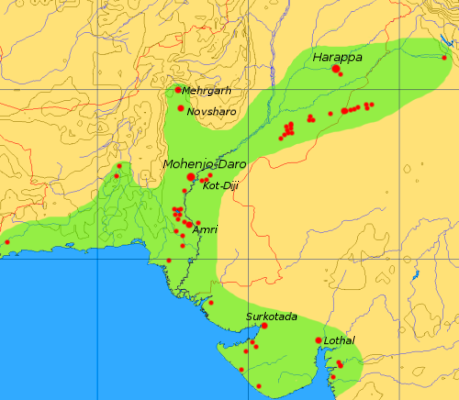
Surkotada is an archaeological site located in Rapar Taluka of Kutch district, Gujarat, India which belongs to the Indus Valley civilisation (IVC).[1][2] It is a smaller fortified IVC site with 1.4 hectares (3.5 acres) in area.[3]: 220 

Location and environment

[edit]

The site at Surkotada is located 160 km (99 mi) north-east of Bhuj, in the district of Kutch, Gujarat. The ancient mound stands surrounded by an undulating rising ground clustered by small sandstone hills. These hills are covered with red laterite soil giving the entire region a reddish-brown colour. The vegetation is scarce and consists of cactus, small babul and pilu trees and thorny shrubs. These give green patches to the red environment. The mound was discovered in 1964 by J. P. Joshi of the Archaeological Survey of India. The mound is higher on the western side and lower on the eastern side and has an average height of 5 to 8 m (16 to 26 ft). In the ancient days, a river 750 m (½ mi) wide flowed past the north-eastern side of the site. This river, which emptied into the Little Rann, might have been an important reason for siting the town here. Now this river is only a small nalla (stream).

Chronology

[edit]

The chronology of the occupation of the site at Surkotada is not the same as other Harappan / Indus Valley civilization sites. The dates from Surkotada are later than most Harappan sites but conform well with the occupational dates from Lothal and Kalibangan. In other words, the Harappans did not establish a settlement in Surkotada in the earliest phase of Harappan maturity but did so almost towards the end. The site of Surkotada was occupied for a period of 400 years with no breaks or desertions. Archaeologists have divided the history of settlement in Surkotada into three cultural phases. The following is a description of the three phases in terms of the building activity:

Period IA (2100 BC – 1950 BC)

[edit]

The earliest occupants of Surkotada had affiliations with an antecedent culture. They built a citadel with mud-brick and mud-lump fortification with a rubble veneer of five to eight courses over a raised platform of hard rammed yellow earth. The platform had an average height of 1.5 m (4.9 ft) and the average base width of the fortification wall was 7 m (23 ft). The bricks used were in the ratio 1:2:4 which conforms with mature Harappan standards. The height of this wall was 4.5 m (15 ft). The residential area was also built with a fortification wall having a thickness of 3.5 m (11 ft). The citadel had two entrances one on the southern side and one on the eastern side for accessing the residential area. In the residential area a drain, a bathroom with a small platform and a soakage jar in every house prove the well known sanitary arrangement and drainage system of the Harappan

Period IB (1950 BC – 1800 BC) There is no break in the continuity of settlement from phase IA to phase IB, but this period has been defined separately due to the arrival of a new wave of people who used a new form of pottery and instruments. They retained the structure of the citadel but added a mud brick reinforcement to the inside of the fortification wall. As this would have only reduced the area within the citadel, it is not clear why they did this. The end of period IB is marked by a thick layer of ash which represents a widespread conflagration.

Period IC (1800 BC – 1700 BC)

[edit]

After the fire of period IB, a new group of people came to Surkotada though the site does not show any break in the continuity of settlement. The new people followed their predecessors in the layout of the settlement and made a citadel and a residential complex on the same lines made of rubble and dressed stones. These measured respectively

Layout of the city and architectural remains

[edit]

The total built up area of Surkotada of the period IC is in the form of a rectangle aligned along the cardinal directions. It measures 120 m (390 ft) east-west and about 60 m (200 ft) north-south. Despite its small size, archaeologists consider Surkotada very important. It had been treated by its builders at par with Kalibangan and Lothal in terms of planning. The gates of Surkotada have also been treated with care and in some respects are different from general Harappan trends. Moreover, many scholars feel that the location of Surkotada was strategic to control the eastward migration of the Harappans from Sind. Surkotada also supports the concept of the feudal system of administration in the civilization . In other words, Surkotada could have functioned as a regional capital or garrison town.

The plan of Surkotada is composed of two squares - the one to the east is called the residential complex and measures 60 by 55 m (197 by 180 ft) while the one on the west is the citadel and it measures 60 by 60 m (200 by 200 ft). The citadel is the higher of the two. The fortification wall of the citadel has an average base width of 3.5–4 m (11–13 ft) and has two 10 by 10 m (33 by 33 ft) bastions on the southern wall. Similar bastions are expected on the northern wall but have not been excavated yet.

On the southern wall of the citadel there is a centrally placed gateway projecting out. This gateway measure 10 by 23 m (33 by 75 ft) and has steps and a ramp leading up to the main entrance which has two guard rooms. There is a 1.7 m (5+12 ft) wide passage leading into the entrance. The citadel consists of large houses some of which have up to nine rooms each. From the citadel there is an entrance in the east wall, again 1.7 m (5+12 ft) wide, for access to the residential complex.

The residential area consists of houses which are the smaller than the citadel houses. A typical example is a house with five interconnected rooms, a courtyard closed on three sides and a platform outside facing the street. The platform would have been used for transactions and as a shop. The southern fortification wall of the residential area also has an entrance which has received a different treatment by its builders. It differs from other Harappan gates in the sense that it is a straight entrance and not a staggered or bent one. The gate itself is set in the thickness of the fortification wall while there are two guard rooms projecting out. The fortification wall of the residential complex has an average thickness of 3.4 m (11 ft) and has bastions at the corners which are smaller than the ones on the citadel fortification wall.

All these features show mature Harappan traits even up to 1700 BC which chronologically is quite remarkable. Mature Harappan principles were being followed in Surkotada long after the civilization itself had started declining and most other sites had decayed or died out.

As of today there is no evidence of a city scale settlement near the citadel complex of Surkotada, as one might be expected on the lines of Mohenjo-daro and Kalibangan. About 500 m (1,600 ft) south-east of the citadel, there is a low mound which represents some sort of small habitation but the Harappan vestiges are scarce. Archaeologists feel that the possibility of the existence of a large settlement is remote but cannot be ruled out.

Horse remains

[edit]

During 1974, the Archaeological Survey of India undertook excavations in this site. J. P. Joshi and A. K. Sharma reported findings of bones at all levels (circa 2100-1700 BCE), which they described as horse bones.[4][5] Sándor Bökönyi (1997), on examining the bone samples found at Surkotada, opined that at least six samples probably belonged to true horse.[1][2][6]

However, archeologists Richard H. Meadow and Ajita Patel disagree, on the grounds that the remains of the Equus ferus caballus horse are difficult to distinguish from other equid species such as Equus asinus (donkeys) or Equus hemionus (onagers).[2][7][8][note 1]

Other significant finds

[edit]

Presence of Mongooses were found in Surkotada as well as in Mohenjadaro, Harappa, and Rangpur, indicating that these animals were kept as a protection against snakes. Elephant bones and wolf bones (tamed?) were also found at Surkotada.[3]: 130–131 

See also

[edit]

Notes

[edit]

References

[edit]

Further reading

[edit]
Revisions and contributorsEdit on WikipediaRead on Wikipedia
from Grokipedia
Surkotada is a small archaeological site of the late Mature Harappan phase of the Indus Valley Civilization, located in the Kutch district of Gujarat, India, covering approximately 3.5 acres with a mound height of 5 to 8 meters. Excavated by J. P. Joshi of the Archaeological Survey of India between 1964 and 1972, the site revealed a fortified citadel with thick stone walls, residential structures, and evidence of a planned settlement divided into periods spanning roughly 2300 to 1700 BCE. The site's layout includes a rectangular interpreted as a , surrounded by a bastioned wall up to 3 meters thick, alongside lower town areas with mud-brick houses and drainage systems typical of Harappan . Artifacts recovered encompass , seals, beads, and tools, reflecting continuity with broader IVC , while faunal remains indicate reliance on , sheep, goats, and notably equids comprising about 1% of the assemblage. Surkotada's significance lies in its peripheral location in a semi-arid environment, suggesting adaptation to challenging terrains, and its association with burial practices including oval graves and pot interments. A defining feature is the discovery of equid bones across stratigraphic levels, initially identified by excavators and subsequent analysts like Sándor Bökönyi as domesticated horses (Equus caballus), prompting interpretations of early horse domestication in the subcontinent predating Indo-Aryan arrivals. However, this identification has faced scrutiny from specialists such as Richard Meadow, who argue the remains more closely resemble onagers (Equus hemionus) or asses based on morphological and contextual evidence, highlighting ongoing debate in archaeozoology influenced by broader historical narratives. Despite the contention, the site's equid evidence underscores Surkotada's role in discussions of animal economy and cultural continuity in the IVC's de-urbanization phase.

Discovery and Excavation History

Initial Surveys and Key Excavations

The archaeological site of Surkotada was identified in 1964 during regional explorations in Kutch by Jagat Pati Joshi of the (ASI), marking it as a potential Harappan settlement mound approximately 3.5 acres in extent and rising 5-8 meters in height. These initial surveys encompassed systematic surface inspections across Kutch, which revealed pottery sherds and structural remains indicative of Indus Valley Civilization (IVC) occupation, prompting targeted investigation at the site. Excavations commenced under Joshi's direction from 1964 to 1968, exposing a citadel with mud-brick fortifications, residential structures, and artifacts including terracotta figurines, seals, and faunal remains, establishing Surkotada's role as a peripheral IVC outpost. Key findings from this phase included evidence of horse bones across strata, later debated for their stratigraphic integrity but reported as contemporaneous with Harappan levels. Subsequent excavations in 1971-1972, also led by Joshi with contributions from , deepened stratigraphic profiling to over 10 meters in places, uncovering three occupational phases (IA, IB, IC) spanning circa 2200-1700 BCE, alongside burials and craft workshops; these efforts yielded the comprehensive ASI report Excavations at Surkotada 1971-72 and Exploration in Kutch. The work emphasized meticulous grid-based trenching and artifact cataloging, providing foundational data on IVC eastern extensions in despite the site's modest scale.

Methodological Approaches and Dating Techniques

Excavations at Surkotada were directed by of the from 1964 to 1968, utilizing systematic stratigraphic excavation techniques prevalent in mid-20th-century protohistoric in . Trenches were strategically placed to uncover the site's fortified , residential annexe, and peripheral structures, with horizontal exposure of walls and vertical profiling of deposits to delineate cultural layers. This approach revealed a consistent layout across phases, including rubble-built fortifications up to 7 meters thick at the base, and allowed for the recovery of artifacts , such as , faunal remains, and seals, through careful sieving and layer-by-layer documentation. The site's chronology was established via a combination of relative and absolute dating methods, prioritizing stratigraphic superposition and artifact associations. Relative dating relied on ceramic typology and seriation, linking Surkotada's red-slipped wares, bichrome pottery, and incised motifs to broader Harappan sequences at sites like Lothal and Dholavira, where similar vessel forms and fabric analyses indicated temporal overlap. Architectural modifications, such as revetments added in later phases, further supported phasing into Periods IA, IB, and IC based on superposition and superposition of building levels. Absolute dating incorporated radiocarbon (C14) analysis of and samples from stratified contexts, calibrating the overall occupation to circa 2300–1700 BC. Key determinations include dates for Period IB at 1970 ± 115 BC and 1745 ± 105 BC, obtained from organic materials associated with enhancements and domestic hearths, confirming a late Mature Harappan to post-urban transition without early phases typical of core IVC sites. These results align with comparative C14 data from regional contemporaries, though sample selection emphasized short-lived materials to minimize old-wood effects.

Geographical and Environmental Context

Site Location and Topography


Surkotada lies in Rapar taluka of Kutch district, Gujarat, India, roughly 160 kilometers northeast of Bhuj city and 50 kilometers from Rapar town. The site is positioned in the semi-arid alluvial plains of northern Kutch, proximate to the expansive salt flats of the Rann of Kutch.
The archaeological remains occupy a small spanning 3.5 acres, with rectangular dimensions of approximately 120 meters east-west by 60 meters north-south. The exhibits an average elevation of 5 to 8 meters above the surrounding terrain, sloping downward from west to east. This elevated position, amid undulating ground and scattered hillocks, provided a strategic vantage in the region's flat, dry landscape. The local features reddish-brown lateritic soil and sparse xerophytic , including cacti, babul (Acacia nilotica) trees, pilu bushes, and other prickly shrubs adapted to the arid conditions. Proximity to ancient watercourses, evidenced by a former river channel about 750 meters wide nearby, underscores the site's adaptation to a challenging paleoenvironment.

Paleoenvironmental Conditions

The region surrounding Surkotada during its occupation (approximately 2100–1700 BC) featured a with seasonal supporting sparse vegetation adapted to periodic , as inferred from regional sedimentary and archaeological proxies in the Kutch peninsula. Geological reconstructions indicate that the adjacent functioned as a shallow, brackish embayment or system, influenced by mid-Holocene sea levels 1–6 meters higher than present, enabling tidal influences and estuarine conditions that facilitated connectivity with the via paleo-channels. This hydrological regime likely included saline marshes and intermittent fluvial inputs, contrasting with the modern hyper-arid salt flats and reflecting a more dynamic aquatic landscape conducive to Harappan settlement and exploitation. Palynological evidence from Surkotada sediments points to a grassland-dominated environment, with pollen of species (foxtail millets) suggesting open savannas interspersed with scrub vegetation such as and , suitable for and limited dry farming. Regional studies from nearby Kutch sites corroborate a tropical dry flora reliant on variability, with estimates of annual rainfall around 300–500 mm during the early to mid-Harappan phases, transitioning toward intensified by circa 1900 BC due to weakening summer . This environmental shift, evidenced by sedimentological indicators of reduced fluvial activity, may have constrained water availability and contributed to the site's eventual abandonment.

Chronological Framework

Period IA (2100–1950 BC)

Period IA marks the earliest Harappan occupation at Surkotada, dated to circa 2100–1950 BC through radiocarbon analysis of charcoal samples. The settlers constructed a rectangular citadel fortified with mud-brick and mud-lump walls averaging 7 meters in basal thickness, featuring two gateways on the southern face, alongside a residential annexe built from mud bricks, lumps, and rubble. This phase revealed three successive structural sub-phases, indicating rebuilding or renovation within the citadel enclosure, with no evidence of a lower town or expansive urban layout. Key artifacts included typical early Harappan pottery such as wheel-turned vessels and copper/bronze objects, reflecting technological continuity with core Indus regions. Faunal assemblages comprised 1.2% equid remains, initially classified as domestic (Equus caballus) by osteologist Sándor Bökönyi based on metapodial morphology, though subsequent re-evaluations by Richard Meadow argue for wild (Equus hemionus khur), a regionally abundant species, citing size variability and contextual scarcity of true horse evidence in contemporaneous Indus sites. These findings suggest pastoral adaptations to the arid Kutch environment, with equids likely serving utilitarian roles amid a mixed economy of and limited .

Period IB (1950–1800 BC)

Period IB at Surkotada, dated approximately 1950–1800 BC, demonstrates uninterrupted settlement continuity from Period IA, with the persistence of core Harappan architectural and material cultural traits amid gradual refinements. The citadel fortifications, initially constructed in mud bricks during IA, received an added layer during this phase, enhancing structural stability against environmental stresses such as erosion or flooding in the arid Kutch region. Residential structures outside the citadel included mud-brick houses with associated hearths—both circular and rectangular—reflecting sustained domestic routines centered on cooking and possibly . Pottery assemblages in Period IB align with Mature Harappan typologies, featuring wheel-turned vessels in red ware with black painted motifs, alongside the introduction of refined ceramic techniques that indicate technological progression without cultural rupture. Metal artifacts, including implements, and terracotta objects such as figurines and seals, underscore linkages and standardized craftsmanship typical of the broader Indus network. Faunal evidence reveals equids constituting 2.2% of identifiable bones, higher than in IA (1.2%), pointing to their sporadic presence amid dominant and sheep/ remains, though interpretive debates persist regarding species identification and status. The phase concludes with a distinct stratigraphic layer of thick, uneven ash extending across the site, evidencing a major fire event that likely devastated the settlement, potentially contributing to depopulation or reconfiguration leading into Period IC. This conflagration layer, absent in earlier sub-phases, marks a terminal disruption, with no immediate evidence of rebuilding atop it, aligning Surkotada's trajectory with wider Mature Harappan decline patterns in peripheral sites.

Period IC (1800–1700 BC)

Period IC at Surkotada, spanning approximately 1800–1700 BC, commenced immediately following a destructive that marked the end of Period IB, prompting resettlement by a possibly distinct group of inhabitants who adhered to the site's established cardinal-aligned rectangular layout measuring about 120 meters east-west. Structures were predominantly constructed using mud bricks and mud lumps reinforced with rubble, including internal reinforcements added to the existing fortifications, indicating a phase of reconstruction and adaptation rather than wholesale abandonment. This period reflects continuity in fortified settlement patterns typical of the Mature Harappan phase, though with evident material shifts toward less durable building techniques compared to earlier baked brick usage. Archaeological evidence from Period IC includes faunal remains such as bones of the true horse (Equus caballus), alongside those of the ass (Equus asinus), recovered in quantities consistent with prior sub-periods, comprising about 1.49% of identifiable bones, supporting interpretations of equid utilization in the local economy. Material culture artifacts encompass tools like a heavy celt and , alongside typical n beads and chert blades, suggesting sustained craft activities and trade links. Pottery assemblages feature white-painted , primarily bowls with or without carination, stud-handles, and an inscribed seal, pointing to stylistic evolution within the broader Indus ceramic tradition. The absence of a lower town extension persists, confining the settlement to the citadel and annexe, which may indicate a defensive or resource-constrained adaptation amid regional environmental stresses or socio-economic changes in the late Mature Harappan context. These findings, derived from excavations by of the between 1964 and 1972, underscore Surkotada's role as a peripheral yet resilient outpost, with no evidence of cultural rupture despite the post-fire influx.

Architectural and Urban Features

Citadel Design and Fortifications

The citadel at Surkotada formed an elevated, rectangular enclosure distinct from the adjacent residential annexe, together comprising a compact fortified settlement without an extensive lower town. Constructed during the Mature Harappan phase circa 2100–1700 BCE, the citadel's fortifications included massive walls with a base thickness of approximately 7 meters, built using mud bricks on rubble foundations and incorporating local elements for added durability. These walls encircled the citadel and annexe with a common perimeter, emphasizing defensive architecture suited to the site's strategic location amid sandstone hills. Access to was controlled through an imposing gateway complex, featuring projections and possible guardrooms for security, with evidence of later modifications including an intercommunicating ramp and additional gateway linking it to the residential annexe. The overall wall reached heights of up to 5 meters in preserved sections, with thicknesses varying to 2.5–4.25 meters in the annexe area, reflecting phased and reinforcement across Periods IA to IC. This design highlights Surkotada's role as a fortified outpost, prioritizing robust perimeter defense over internal complexity. Notable for its use of stone in fortifications—contrasting with the predominant mud-brick construction at many Indus sites—these features underscore adaptive engineering to local geology, including sandstone slabs in basal courses for stability against environmental stresses. Excavations by revealed no bastions but confirmed the walls' integration with the mound's , enhancing natural defensibility.

Settlement Layout and Absence of Lower Town

Surkotada's settlement was a compact, fortified complex spanning approximately 3.5 acres, comprising a citadel and an adjacent residential annexe without an extensive lower town typical of major Indus Valley Civilization sites. The layout featured two primary sections divided by a street: the citadel, oriented to the west, and the residential annexe to the east, both enclosed by rubble fortifications that persisted across the site's three cultural periods (IA–IC, circa 2300–1700 BC). Houses within the annexe included features such as verandahs, wells, bathrooms, and drains constructed from mud bricks, mud lumps, and rubble, indicating organized domestic planning on a modest scale. Access to the occurred via a southern entrance of moderate dimensions lacking ornamental embellishments, while the residential annexe had a southeastern entrance with similar simplicity; an intercommunicating ramp linked the two areas, later modified with a gateway addition. These fortifications, initially exposed as rubble structures, received a reinforcement during Period IB (circa 1950–1800 BC), underscoring a emphasis on defense over urban expansion. The site's excavator, Jagat Pati Joshi of the , conducted digs from 1964 to 1968, revealing no evidence of a broader lower town inhabited by common populations, distinguishing Surkotada from larger Harappan centers like or that segregated elite citadels from expansive residential lowers. This absence of a lower town suggests Surkotada functioned primarily as a small, self-contained outpost or fortified enclave, possibly prioritizing in a peripheral region of the amid environmental or strategic pressures, rather than supporting large-scale urban habitation. The overall design reflects Harappan principles of rectilinear and but on a reduced footprint, with no internal grid of streets extending beyond the core enclosures.

Key Archaeological Finds

Faunal Remains Including Equids

The faunal assemblage at Surkotada, analyzed primarily by , is dominated by domestic ungulates, reflecting a economy integrated with typical of Harappan sites in . (Bos indicus) bones constitute the largest portion, approximately 40% of identifiable remains across Periods IA, IB, and IC (ca. 2100–1700 BCE), underscoring their central role in subsistence, traction, and possibly ritual practices. Sheep (Ovis aries) and goats (Capra hircus) follow, comprising roughly 20% combined, with evidence of for wool and milk. (Bubalus bubalis) and pigs (Sus scrofa domesticus) are present in smaller quantities, around 5–10% each, indicating supplementary herding strategies adapted to the arid Kutch environment. Wild species, such as (Antilope cervicapra) and gazelle (Gazella bennettii), account for less than 5% of the total, suggesting limited reliance on hunting. Equid remains, including those tentatively identified as true horse (Equus caballus) and ass (Equus asinus), were recovered from all three periods, totaling about 1–2% of the faunal sample: 1.2% in Period IA, 2.2% in IB, and 1.49% in IC. Excavators and described these as a "good number" of bones, including skull fragments, vertebrae, and long bones, attributing them to domesticated equids used possibly for transport or labor. Hungarian zooarchaeologist Sándor Bökönyi, in his 1997 examination of select specimens, confirmed Equus caballus based on dental morphology and metapodial measurements, arguing for their presence in late 3rd-millennium BCE contexts and challenging narratives of horse absence in the mature Harappan phase. However, these identifications remain contested, with American zooarchaeologist critiquing Bökönyi's conclusions in a 1998 response, noting that key measurements (e.g., upper occlusal patterns and metacarpal indices) align more closely with wild (Equus hemionus) or hemione-half-ass hybrids indigenous to the region than with domesticated Equus caballus. Meadow emphasized the small sample size—fewer than 20 equid fragments overall—and potential stratigraphic mixing, arguing that definitive evidence requires larger, better-preserved assemblages with comparative metrics from unambiguous post-Harappan horse sites. This debate highlights challenges in distinguishing equid taxa from fragmented remains in arid-site contexts, where post-depositional erosion and low bone preservation rates complicate analysis. Subsequent studies have not resolved the issue, as no additional equid-specific re-examinations using or advanced have been reported for Surkotada.

Artifacts, Pottery, and Material Culture

The pottery from Surkotada excavations, conducted by J. P. Joshi between 1964 and 1968, predominantly features classical Harappan forms such as jars, bowls, beakers, and dishes-on-stands in red and buff wares, consistent with assemblages from major Indus sites like and . These ceramics exhibit the Sorath Harappa regional variant typical of Kutch and Saurashtra, with painted decorations including curvilinear motifs, wavy horizontal lines, and obliquely hatched patterns on overlapping circles, reflecting local adaptations within the broader Indus ceramic tradition spanning Periods IA to IC (c. 2100–1700 BCE). Copper artifacts include a heavy celt, chisel, beads, and bangles, indicating metallurgical skills aligned with Harappan standards and likely used for woodworking, adornment, or tooling. Steatite seals bearing Indus script motifs, alongside semi-precious stone and shell beads, chert blades, and terracotta objects such as toys and bangles, form the core of non-ceramic finds, suggesting engagement in trade, personal ornamentation, and domestic activities typical of Indus material culture. No gold jewelry or elaborate stone sculptures were reported, underscoring Surkotada's status as a modest fortified settlement rather than a major urban center. The overall material repertoire shows strong conformity to Harappan norms, with minimal evidence of post-urban innovations or external influences beyond regional stylistic variations.

Scholarly Interpretations and Debates

Implications for Indus Valley Civilization Dynamics

The fortified structure of Surkotada, encompassing the entire 1.4-hectare settlement without a distinct lower town, deviates from the dual-citadel-and-urban-pattern seen in core IVC sites like or , implying a specialized defensive or administrative outpost in the arid Kutch periphery. This configuration, with rubble-filled stone walls up to 3 meters thick and rectangular bastions, suggests heightened security concerns, possibly against nomadic incursions, resource competition, or seismic risks in a seismically , thereby indicating that IVC dynamics included localized militarization or vigilance rather than uniform across the civilization's expanse. Equid remains recovered from all stratigraphic periods (ca. 2100–1700 BCE), numbering over 30 fragments and identified by excavator as domestic (Equus caballus), alongside asses (Equus asinus), point to pastoral integration of equids in Harappan subsistence, potentially enabling enhanced mobility for or in marginal environments. This challenges the conventional view of as absent or post-Harappan introductions, suggesting possible early domestication or exchange networks extending to , which could have facilitated technological diffusion or socio-economic shifts within IVC borderlands. However, the identification remains contested, with critics attributing the bones primarily to regionally abundant wild onagers (Equus hemionus khur) due to morphological similarities and the scarcity of evidence elsewhere in IVC assemblages, necessitating advanced re-analysis like profiling to resolve chronological and taxonomic ambiguities. Collectively, Surkotada's attributes underscore IVC's heterogeneous dynamics, with peripheral sites adapting through compact, fortified designs and faunal reliance on drought-resistant , reflecting resilience to climatic fluctuations—evidenced by the site's occupation amid 4.2 kiloyear events—and possible intra- or extra-civilizational pressures that presaged the Late Harappan fragmentation. This variability implies a decentralized capable of regional specialization, rather than a monolithic urban , influencing interpretations of IVC's expansive reach and eventual transformation.

Horse Evidence Controversy and Chronological Challenges

Excavations at Surkotada, conducted by and in the , uncovered equid remains across its three cultural periods (IA, IB, and IC), comprising 1.2% of faunal remains in IA, 2.2% in IB, and 1.49% in IC. initially identified these as domestic horse (Equus caballus) bones, a claim later supported by Hungarian archaeozoologist Sándor Bökönyi, who examined photographs and descriptions in 1997 and affirmed the presence of true horse based on morphological features like metapodial proportions and skull fragments distinguishing it from local wild asses (Equus hemionus khur) or onagers. These findings, dated to approximately 2100–1700 BCE via cross-dating with Harappan pottery and stratigraphic correlations, suggested horse presence during the mature and late Harappan phases, predating the conventional timeline for horse introduction to the subcontinent around 1500 BCE. The identification sparked significant debate, with critics like arguing that distinguishing from ass or bones is unreliable without extensive comparative samples, as equid metapodials exhibit overlapping traits and Surkotada's small sample (fewer than 20 fragments) lacked definitive diagnostics like full skulls or for species-level certainty. , a zooarchaeologist specializing in South Asian faunas, contended that Bökönyi's assessment relied on inadequate visual data and that re-examination of physical specimens favored over , aligning with broader Harappan equid evidence interpreted as wild or semi-domesticated asses rather than introduced horses. Proponents, including , emphasized contextual evidence like the site's fortified and absence of wild equid habitats nearby, suggesting , though no harness or artifacts corroborate use. This dispute underscores methodological challenges in archaeozoology, where bone fragmentation and taphonomic biases complicate equid , with no subsequent DNA analysis resolving the issue due to poor preservation. Chronologically, Surkotada's sequence diverges from core IVC sites like Mohenjo-Daro, with its periods spanning circa 2300–1700 BCE based on pottery typology and limited radiocarbon dates, placing equid remains in late Mature Harappan layers potentially overlapping post-urban decline phases. Critics highlight inconsistencies, such as reliance on relative dating without robust absolute calibration for Gujarat's peripheral sites, where erosion and reuse of materials may inflate antiquity; recent reassessments propose compressing the timeline to 2000–1500 BCE, aligning equid evidence with transitional periods but questioning pre-2000 BCE horse claims. These challenges amplify interpretive tensions, as horse domestication evidence elsewhere (e.g., Eurasian steppes circa 3500 BCE) implies introduction rather than local origins, yet Surkotada's dating resists integration with genetic models favoring post-2000 BCE influxes of horse-associated cultures. Absent confirmatory isotopic or genetic studies, the site's evidence remains pivotal yet unresolved in debates over IVC faunal economies and external influences.

References

Add your contribution
Related Hubs
Contribute something
User Avatar
No comments yet.