Hubbry Logo
Thorp ArchThorp ArchMain
Open search
Thorp Arch
Community hub
Thorp Arch
logo
8 pages, 0 posts
0 subscribers
Be the first to start a discussion here.
Thorp Arch
Thorp Arch
from Wikipedia

Thorp Arch is a village and civil parish near Wetherby in the City of Leeds metropolitan borough of West Yorkshire, England.

Key Information

Governance

[edit]

Geography and amenities
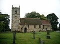
[edit]

The village is on the north bank of the River Wharfe which separates it from Boston Spa to the south. It has a primary school and public house. Historically the parish of Thorp Arch was in the Ainsty, a division of Yorkshire, separate from the ridings. It had a population of 1,123 in 2001,[2] increasing to 1,591 at the 2011 census.[1] The parish church of All Saints was founded in the 12th century. It has a 15th-century tower but the rest was built in 1871 and 1872. It is a Grade II listed building.[3]

The village is adjacent to Thorp Arch Trading Estate, Wealstun Prison, and the British Library Document Supply Centre.[4]

Transport

[edit]

The village railway station, now closed, was next to the trading estate on the closed Harrogate to Church Fenton Line. Current-day public transport is provided by bus route 7 to Harrogate, Wetherby and Leeds, operated by the Harrogate Bus Company.

Sport

[edit]

Leeds United's training ground and academy are based on Walton Road. The facility was opened in 1990 to replace one adjacent to the club's Elland Road football stadium in Leeds.

Location grid

[edit]

See also

[edit]

References

[edit]
[edit]
Revisions and contributorsEdit on WikipediaRead on Wikipedia
from Grokipedia
Thorp Arch is a village and in the , , , situated on the northern bank of the River Wharfe midway between and . With a of 1,575 as recorded in the , it is a small, affluent rural community characterized by its linear layout along a historic main street, magnesian buildings, and surrounding gently rolling farmland. The village is adjacent to the 385-acre Thorp Arch Estate, a major commercial hub hosting around 180 businesses and employing more than 5,500 people, which originated as a Second World War munitions site. Thorp Arch's history traces back to prehistoric times, with evidence of , , and remains in the vicinity, alongside Roman activity including the nearby Rudgate road and villa sites. The first written record appears in the of 1086, where it is listed as "Torp" and described as comprising three farms, a church, and a mill under Norman lordship. Following the , it became an estate village associated with the de Arches family, developing a medieval toft-and-croft layout that persisted into the . Key 18th-century landmarks include Thorp Arch Hall, a Georgian mansion built between 1753 and 1756 by architect John Carr for William Gossip, and a stone bridge over the River Wharfe constructed in 1770. The village's ecclesiastical center is the Grade II listed All Saints Church, ordained as a vicarage in 1258 and augmented in value during the early through charitable contributions. Industrial elements include historic mills along the Wharfe—such as Manor Mill (operational from before 1086 until 1958) and Flint Mill (1772–1954)—which supported local and later . The arrival of the railway in 1847 connected Thorp Arch to broader networks until its closure in 1964, after which the line was repurposed as a Sustrans cycle path. In the 20th century, the village experienced housing growth from 47 dwellings in 1945 to over 100 by the 1970s, with recent developments like the 2020 Blossomfields project adding 145 new properties and allotments. Today, Thorp Arch blends heritage with contemporary amenities, including a with , proximity to outdoor pursuits along the River Wharfe, and facilities like the Thorp Arch & Cricket Club. The Thorp Arch Estate, redeveloped from the wartime factory, now features modern infrastructure such as net-zero warehouses and full fibre connectivity, underscoring the area's economic significance while preserving its parkland setting. The village also hosts the British Library's northern depository at , storing a significant portion of the collection including over 8 million books and serials, further highlighting its role in cultural preservation.

History

Early settlement and medieval period

Evidence of early settlement in the Thorp Arch area includes prehistoric remains from , , and periods, as well as nearby Roman activity. The first written record dates to the late Anglo-Saxon period, with the village recorded as "Torp" in the of 1086. This survey, commissioned by , described the settlement as comprising 14 households, three ploughlands, and a church, all situated on the north bank of the River Wharfe in the historic county of . The name "Thorp" derives from the Old Norse word þorp, signifying a or secondary settlement, which underscores the Viking influences prevalent in the region during the era, when Norse settlers established numerous agricultural outposts across . The affix "Arch" likely refers to the de Arches family, Norman lords who held the manor post-Conquest, reflecting the layered linguistic and tenurial history of the area. Administratively, Thorp Arch fell within the wapentake, a distinctive subdivision of that maintained a semi-autonomous status outside the formal boundaries of the West and North Ridings until the , allowing it unique jurisdictional privileges under the Crown. During the medieval period, the community centered around agrarian activities and ecclesiastical life, exemplified by the founding of All Saints’ Church in the in Norman style, as a rebuild of the earlier Domesday-era structure. The church's tower, a prominent feature, was added in the , enhancing its role as a focal point for governance and worship amid the evolving feudal landscape. This continuity highlights Thorp Arch's stability as a rural through the High and , prior to later transformations.

Industrial development and 20th century

The construction of Thorp Arch Bridge in 1770 marked a significant infrastructural advancement for the village, replacing a downstream ford on the River Wharfe with a durable ashlar magnesian limestone structure featuring five segmentally-arched spans, two of which cross the river itself. This Grade II listed bridge, with its triangular cutwaters and continuous parapet band, facilitated reliable crossings between Thorp Arch and Boston Spa, supporting local travel and trade. Throughout the 19th century, Thorp Arch remained predominantly agricultural, with farmland dominating the landscape, though minor industrial activity emerged through water-powered mills along the river, including operations for corn grinding, bobbin making, flax processing, paper production, and oil extraction. In 1871–1872, All Saints’ Church underwent a major restoration led by architect , who rebuilt the body of the structure in a medieval style while preserving the original 15th-century tower. This work modernized the church for continued use by the growing village community without altering its historic core. The advent of transformed Thorp Arch's economy dramatically, as the compulsorily acquired 642 acres of former farmland in 1940 to construct (ROF) Thorp Arch, designated Filling Factory No. 8. Completed in 1942 at a cost of £5.95 million, the sprawling complex—spanning over 500 buildings—produced munitions including rifle bullets, naval shells, 20mm cannon rounds for Spitfires, and 1,000-pound bombs, operating around the clock in three shifts. At its peak, the factory employed up to 18,000 workers, predominantly women, many commuting via an extensive internal circular railway system connected to LNER lines, complete with dedicated sidings and four workers' platforms. Following the war's end in 1945, ROF Thorp Arch ceased full-scale production and served briefly as a storage depot for surplus materials before reopening in 1950–1953 to support munitions needs during the . The site was formally closed in 1957 and, in the early , sold to private developer George Moore, who converted it into the Thorp Arch Trading Estate, shifting the area from wartime industry to commercial and light industrial uses.

Geography

Location and landscape

Thorp Arch is a situated in the metropolitan borough, , , positioned approximately 3 miles southeast of and 3.5 miles northwest of , along the north bank of the River Wharfe. The boundaries encompass mixed farmland, woodland, and developed areas, stretching about 5 km in length with varying widths from 1 km in the north to 3 km in the south; the southern and western edges are defined by the River Wharfe, the northern by Wetherby Road and the B1224, and the eastern by farmland and the Thorp Arch Estate adjacent to Walton parish. The landscape features the fertile, gently undulating terrain of the , characterized by open agricultural fields, hedgerows, deciduous woodlands, and historic parkland, with elevations typically ranging from 20 to 40 meters above and lower flood meadows (Ings) below 20 meters; its proximity to the Wharfe Valley contributes to scenic riverine views and occasional flood influences on the low-lying areas. Thorp Arch lies within the historic Ainsty region, an ancient wapentake adjacent to the that held unique administrative status outside the traditional ridings, governed directly by York's corporation rather than the county's broader divisions.

River Wharfe and notable features

The forms the southern boundary of Thorp Arch parish, flowing through a gorge carved into the magnesian by glacial meltwaters, which shapes the local and defines the area's hydrological character. This river corridor supports diverse ecological habitats, including riparian zones that sustain species such as otters (Lutra lutra) and water voles (Arvicola terrestris), contributing to the broader of the Wharfe valley within . Along its banks near Thorp Arch, the river facilitates recreational walking paths, such as those integrated into local circular routes that follow the floodplain and connect to nearby areas like , offering access to scenic riverside environments. A prominent feature spanning the River Wharfe is Thorp Arch Bridge, constructed in 1770 from magnesian with five segmentally arched spans, two of which cross the river's course. The bridge, which forms part of the parish boundary and links Thorp Arch to the adjacent parish of , holds Grade II listed status due to its special architectural and historic interest, as recognized for its elegant design and enduring role in local connectivity. Flood management efforts have also been integral to the river's interaction with the area, with 20th-century defenses—including weirs and embankments—implemented to mitigate periodic inundations of adjacent meadows, particularly following disruptions from World War II-era developments that heightened flood risks through altered land use. These measures, while reducing regular flooding, allow controlled overflows during high water events to preserve the river's natural dynamics. Environmentally, the River Wharfe enhances local through its varied habitats, including grasslands and edges that form part of designated Local Wildlife Sites near Thorp Arch, supporting , nesting birds, and pollinators amid the magnesian geology. Complementary walking trails, such as the Wetherby Railway Path and Thorp Arch Circular, leverage these features for public enjoyment, promoting awareness of the river's ecological value while traversing habitats along its banks.

Governance

Local government

Thorp Arch functions as a within the , governed by the Thorp Arch Parish Council, which oversees local planning applications, organizes community events, and maintains amenities such as the village hall. The council operates as an unwarded parish with six elected councillors, representing the interests of approximately 841 electors in the community as of September 2025. Following the local government reorganization under the Local Government Act 1972, effective in 1974, Thorp Arch transitioned from Wetherby Rural District to integration within , where it forms part of the Wetherby ward. In this structure, the parish council handles grassroots administration, while delivers borough-wide services, including through the Wetherby (Thorp Arch) household waste recycling centre and highways maintenance. The Thorp Arch Parish Council has actively contributed to preserving the village's rural character through initiatives like the Village Design Statement, produced in collaboration with a steering group and approved as supplementary planning guidance by in 2004. This document, developed amid pressures from potential large-scale developments such as expansions at the nearby trading estate, provides guidelines for future building and landscape management to enhance and protect the parish's historic and environmental qualities. The council also led the development of the Thorp Arch Neighbourhood , adopted in 2018, which sets local policies for , , and environment up to 2028.

Electoral districts

Thorp Arch is included in the ward of , one of 33 wards in the that each elect three councillors to serve four-year terms on matters such as local planning, highways, and community welfare. The ward covers a in northeast , incorporating villages like Thorp Arch, , Bramham, Clifford, and Walton, with elections staggered so one-third of seats are contested annually. At the national level, Thorp Arch forms part of the Wetherby and Easingwold parliamentary constituency, established under the 2023 Periodic Review of Westminster constituencies and first used in the 2024 ; it is represented in the by Sir of the Conservative Party. This cross-county seat spans parts of and , including , , and surrounding rural districts. Prior to 2024, following boundary changes implemented for the 2010 , the village had been within the and Rothwell constituency. Historically, Thorp Arch's electoral governance reflected its position in the , a distinct wapentake outside Yorkshire's traditional ridings, where it fell under the Wetherby Rural District Council from until the Local Government Act 1972 restructured administration effective 1 April 1974. This reform abolished the rural district and integrated the parish into the expanded metropolitan district within the new metropolitan county, aligning it with modern urban and regional electoral frameworks.

Economy

Thorp Arch Trading Estate

The Thorp Arch Trading Estate originated from the repurposing of the former site following , with approximately 450 acres acquired in 1960 by local businessman George Moore and subsequently redeveloped into a mixed-use encompassing industrial, warehousing, and retail facilities. Today, the estate spans 385 acres in a parkland setting, providing around two million square feet of space across more than 250 units occupied by diverse tenants ranging from startups to large corporations. This evolution has transformed the site into a key economic driver, supporting and through modern, flexible premises tailored to tenant needs. Prominent employers on the estate include the British Library's Document Supply Centre, established at the site's entrance in in 1973, which manages a vast collection of journals, books, and documents, facilitating interlibrary loans and research access worldwide. Additionally, , opened in 1995 on the estate grounds as a Category C facility for adult males, accommodates over 800 inmates and employs hundreds of staff in operational, training, and resettlement roles. Together with other tenants, these anchors contribute to over 2,000 direct jobs, bolstering local employment in the . The estate's strategic position, equidistant from Leeds, Harrogate, and York with proximity to the A1(M) motorway, enhances its role in regional logistics and supply chains, significantly impacting the local economy through sustained business activity and infrastructure investment. Recent expansions underscore this growth, including the 2024 submission for Ash Way V—a £8 million development of three net-zero warehouse units totaling over 76,000 square feet, featuring solar panels to generate free electricity for tenants and reduce carbon emissions. These sustainability initiatives align with broader environmental goals, such as biodiversity enhancement on the estate's calcareous grasslands, positioning Thorp Arch as a forward-looking commercial hub into 2025.

Agriculture and local businesses

Thorp Arch's agricultural landscape has evolved significantly since the medieval period, when the featured nucleated settlements with large open fields organized under a four-field system, supporting tenant farmers and evidenced by surviving patterns north of Dowkell Lane. Post-World War II, much of the farmland underwent reallocation due to the compulsory purchase of 642 acres in 1940 for a , which temporarily shifted land use from agriculture to munitions production until the site's closure in 1958 and subsequent conversion into the dominant Thorp Arch Trading Estate. Remaining lands, now comprising large hedged fields averaging around 20 acres, continue to support arable farming with crops such as , , potatoes, and silage grass, alongside limited activities including sheep and stock rearing. Today, only three active farms operate within the parish, all managed by tenant farmers primarily focused on arable production with supplementary grazing. These operations reflect a broader transition from self-sufficient medieval farming to modern diversified models, incorporating leisure elements such as equestrian activities that utilize the surrounding countryside for horse riding alongside public paths like the Ebor Way. Local planning policies encourage such farm diversification to enhance profitability while preserving landscape features like hedgerows and green spaces, ensuring agricultural viability amid the estate's economic prominence. Small-scale businesses in Thorp Arch complement the rural economy by serving daily needs and fostering community ties, with the historic Pax Inn standing as a central hub. Originally constructed as a thatched village in the to cater to local farmers and workers—first documented around 1880 and formerly known as The Goat's Head—the Pax Inn has evolved into a family-run establishment offering traditional British fare and acting as a non-designated that supports social gatherings and light tourism drawn to the village's scenic riverside location. While historical records note a former and alongside a blacksmith's shop, contemporary village amenities are limited, with residents often relying on nearby for additional retail; the Pax Inn nonetheless bolsters local tourism by highlighting Thorp Arch's heritage and proximity to the River Wharfe. Agriculture employs a small minority of the parish's , with the three farms sustaining limited roles amid a of 1,575 residents, many of whom commute to nearby towns like and for employment in non-agricultural sectors. This reflects the estate's overarching influence on local jobs, yet policies promote low-impact growth in rural enterprises to maintain the area's agricultural character and support diversified income streams.

Community and amenities

Education and schools

The primary educational institution in Thorp Arch is Lady Elizabeth Hastings' Voluntary Aided , located on Dowkell Lane and serving children aged 4 to 11 in the local community. The school, a mixed-gender establishment under , currently enrolls approximately 109 pupils across five mixed-age classes and emphasizes Christian values alongside a broad curriculum that includes to foster an understanding of the rural setting. It received a "Good" rating in its latest inspection in July 2024, highlighting strong leadership and pupil well-being in this small village environment. The school's origins trace back to 1836, when it was established as a church school to provide education for the children of Thorp Arch parish, initially catering to the needs of the local agricultural economy with basic instruction in . It was endowed by the philanthropist Lady Elizabeth Hastings (1682–1739), whose legacy supported several educational initiatives in the area, reflecting her commitment to promoting education and religion among the poor. Over time, the institution evolved into its current voluntary aided status, integrating modern facilities while maintaining its affiliation and ties to the ecclesiastical parishes of Thorp Arch and Walton. For secondary education, Thorp Arch lacks dedicated facilities but benefits from proximity to nearby institutions, including in (approximately 2 miles away) and Wetherby High School in (about 4 miles distant), with pupils typically transitioning via coordinated admissions managed by . Access to these schools is supported by local bus services and parental transport, ensuring continuity for students beyond primary level. Higher education options are not available on-site, with residents relying on further travel to colleges and universities in nearby towns such as or .

Religious sites and public houses

All Saints' Church serves as the primary religious site in Thorp Arch, functioning as the active for the local community within the Bramham Benefice of the . Recorded in the of 1086, the church originated in the with a Norman-style rebuild, followed by Perpendicular additions around 1485 and a major restoration in 1871–1872 that incorporated Gothic Revival elements. Designated as a Grade II listed building, it features historical elements such as a choir screen and altar rails added in 1944 by woodcarver Robert 'Mouseman' Thompson, alongside modern accessibility improvements including wheelchair access and a hearing loop. The church hosts regular Sunday services, including Holy Communion on the first Sunday of the month and Parish Worship on the fourth Sunday, both at 9:30 a.m. Beyond worship, All Saints' Church plays a vital role in community events that strengthen social bonds, such as afternoon teas, barbecues, harvest suppers, flower festivals, and educational talks. These gatherings, held throughout the year, reflect the church's enduring position as a hub for local interaction, drawing on its medieval history as the for nearby Walton until 1369, when it handled baptisms, marriages, and burials across the region. The Pax Inn stands as Thorp Arch's historic public house, offering dining options with home-cooked meals using local ingredients and a selection of hand-pulled ales in a welcoming country setting. First mentioned as an inn in under the name —a thatched-roof establishment—it was rebuilt in its current form in as the Pax Inn, maintaining its central place in village social life since the . Featuring a large and open fires, the pub fosters community gatherings and has recently reopened under local ownership, continuing to serve as a key venue for casual socializing and events. Other community amenities in Thorp Arch, including venues like the used for social activities, complement the church and pub by hosting events organized by groups such as the Thorp Arch Village Society, which boasts over 150 members and coordinates regular social functions. These spaces contribute to overall community cohesion through organizations like the Mothers' Union and the local magazine The Causeway, which promote shared traditions rooted in the village's location within the historic wapentake of . Such ties to Ainsty heritage, including longstanding ecclesiastical roles, underscore the enduring cultural fabric that binds residents through faith-based and hospitality-centered interactions.

Transport

Road infrastructure

Thorp Arch is primarily accessed via Junction 45 of the A1(M) motorway, located approximately 2 miles to the west, offering direct links to the national motorway network including the M1. Local connectivity is provided by the A659, which runs from the A1(M) near Wetherby towards Boston Spa and leads into the village via Bridge Road. The Thorp Arch Bridge, constructed in 1770 from magnesian with five segmentally arched spans, serves as a vital crossing over the River Wharfe, linking Thorp Arch to and facilitating essential local . Its narrow , a feature of its historic design, often results in challenges for modern vehicles, including near-misses and standoffs between drivers unable to pass. This has necessitated occasional closures for safety inspections and maintenance, such as full-day shutdowns in October 2024 and January 2025 to assess structural integrity. Within the village, the road layout consists of narrow, winding minor roads suited to residential and light traffic, with Walton Road extending southwards to the Leeds United training ground and academy facilities. Access to the adjacent Thorp Arch Trading Estate is supported by internal estate roads, engineered with ample space for maneuvering and capable of accommodating heavy goods vehicles essential to the site's commercial operations. Cycling and pedestrian infrastructure includes dedicated paths along minor roads and integration with the route 665, featuring the traffic-free 6.3-mile Wetherby Railway Path that connects Thorp Arch to Spofforth and broader regional trails. These routes promote safer non-motorized travel, with ongoing improvements such as resurfacing and widening to enhance accessibility.

Public transport and former rail

Public transport in Thorp Arch is primarily served by bus services, with no active passenger rail connections in the village itself. The main route is the number 7 bus, operated by The Harrogate Bus Company (a of ), which provides connections to nearby towns and cities. This service runs hourly, linking Thorp Arch to via , and extending northward to , with stops at key points such as Thorp Arch Village and the Trading Estate. In January 2025, local residents petitioned to restore the service to a half-hourly frequency due to concerns over reliability and capacity. The village's railway history dates to the mid-19th century, when Thorp Arch railway station opened on 10 August 1847 as part of the Church Fenton to branch line, constructed by the York and North Midland Railway. The line's stations, including Thorp Arch (originally known as Thorp Arch for until 1961), were designed by George Townsend Andrews, known for his Tudor Revival-style buildings on the network. Passenger services ceased on 6 January 1964 as part of the , which targeted unprofitable rural lines, and the station closed entirely to goods traffic on 10 August 1964, with the track lifted shortly thereafter. During the Second World War, the Royal Ordnance Factory (ROF) at Thorp Arch featured an extensive internal rail network, including sidings connected to the main line, to facilitate the transport of raw materials and finished munitions such as artillery shells and bombs. This infrastructure supported the factory's role in producing ammunition for the and , with the site's strategic location and rail access enabling efficient logistics away from major population centres. Following the factory's decommissioning in 1959 and conversion to the Thorp Arch Trading Estate, the rail sidings were largely dismantled or left disused, though remnants of the network persist within the estate grounds. Today, Thorp Arch lacks direct rail services, requiring residents to travel to nearby stations for intercity connections; York railway station, approximately 13 miles away by road, offers frequent high-speed services to London and other destinations via the East Coast Main Line.

Sport and recreation

Leeds United facilities

Thorp Arch serves as the primary training ground and academy for Leeds United F.C., located at Thorp Arch Grange on Walton Road in the village of Thorp Arch, near Wetherby. The facility was conceived under manager Howard Wilkinson in 1988 and constructed in the early 1990s with financial support from then-chairman Leslie Silver, before the club relocated its operations from Fullerton Park to the site in 1994. The site spans 12.1 hectares and functions as a comprehensive youth development center, housing the club's academy programs from under-9 to under-21 levels. Key facilities include eight grass pitches, two all-weather pitches, an indoor training area, two physiotherapy rooms, a bio-science laboratory, medical and rehabilitation centers, and residential accommodation for young players at The Grange building, which opened in 2002. Thorp Arch has been instrumental in nurturing elite talent for Leeds United, with notable academy graduates including , who joined the program at age 14 and developed through the facility before making his senior debut in 2015. Other products of the academy include , highlighting its role in the club's pathway to first-team integration. In the , the facility underwent significant upgrades to incorporate modern training technologies, including a hybrid pitch with completed in 2021, enhancements to the first-team , and the addition of a large high-altitude training room equipped with cardio machines—one of the biggest in elite sport. As of 2025, further investments included £3 million allocated for improvements at Thorp Arch, along with changes such as zoned seating and integrated open-plan nutrition areas. The presence of Thorp Arch provides local employment opportunities in , , , and administrative roles, supporting the regional through ongoing operations and investments. Community engagement includes occasional public access, such as free entry to under-21 and guided tours for special guests, fostering ties with supporters and local initiatives.

Local sports clubs

Thorp Arch Lawn Club operates as a small, friendly located in the heart of the village, featuring a well-maintained outdoor court accessible to residents via a small lane opposite The Pax Inn. The club welcomes family and individual memberships, hosts an annual tournament accompanied by a , and uses a group to coordinate casual games and encourage participation from newcomers. The Thorp Arch & Boston Spa Cricket Club (TABS) serves as a key amateur sports entity, with its pitch situated centrally in the village and supporting senior men's teams, a ladies' team, and junior sections for ages 5 to 18, fostering a welcoming environment for players of all experience levels. Affiliated with parish activities, the club historically competes in the and integrates with broader local events, such as social gatherings held at nearby venues in . Community football activities are supported through the use of village fields for informal matches and parish-organized games, promoting grassroots participation among residents. Walking groups in Thorp Arch connect with the surrounding landscape, particularly along the River Wharfe, through the Walking Group, a Ramblers-affiliated organization that organizes regular outings for locals to explore riverside paths and nearby countryside. opportunities are available via the No.1 Angling Association, which manages a stretch of the River Wharfe at Thorp Arch Park as a mixed targeting like , barbel, , pike, and , tied to the area's leisure amenities. These recreational pursuits often intersect with Wetherby sports leagues, where Thorp Arch participants join regional events hosted at the village hall or adjacent facilities. On occasion, local groups benefit from limited community access to nearby professional sports infrastructure for training or events.

References

Add your contribution
Related Hubs
User Avatar
No comments yet.