
Community hub
Recent from talks
Contribute something
Nothing was collected or created yet.
Traverse Gap
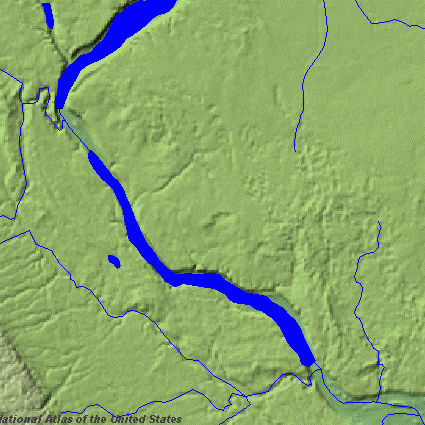
View on WikipediaThe Traverse Gap is an ancient river channel occupied by Lake Traverse, Big Stone Lake, and the valley connecting them at Browns Valley, Minnesota. It is on the border of the U.S. states of Minnesota and South Dakota. Traverse Gap has an unusual distinction for a valley: it is transected by a continental divide,[1] and in some floods, water has flowed across that divide from one drainage basin to the other. Before the Anglo-American Convention of 1818, it marked the border between British territory in the north and U.S.—or, earlier, French—territory in the south.
Key Information

Geological history
[edit]The Traverse Gap was cut at the end of the last ice age. The Laurentide Ice Sheet decayed and receded as the Wisconsonian glaciation drew to a close, and Glacial Lake Agassiz formed from its meltwaters. The glacier blocked outlets to the north, and the outlet to the south was dammed by the Big Stone Moraine, a terminal moraine left by the ice sheet's retreat. Lake Agassiz filled until it overtopped the moraine about 11,700 years ago. The resulting enormous outflow of the lake carved a deep spillway through the moraine, through which cascaded Glacial River Warren.[2] This great river not only created the gap, it also cut the valleys of the present-day Minnesota and Upper Mississippi Rivers. River Warren drained Agassiz twice more over the next 2,300 years,[3] separated by intervals when the ice sheet receded sufficiently to uncover other outlets for Lake Agassiz.[4] About 9,400 years ago, Agassiz found a permanent outlet to the north.[3] With its former source now draining elsewhere, River Warren ceased to flow, and the spillway gorge became the Traverse Gap, now occupied by much smaller lakes and watercourses and a flat valley floor containing marshes, agricultural land, and the small community of Browns Valley, Minnesota.[5]
Topography and hydrology
[edit]
Despite the low elevation and flat topography of its floor, the Traverse Gap marks the southernmost point of the Northern Divide between the watersheds of the Arctic and the Atlantic Oceans. On the north, Lake Traverse is the source of the Bois des Sioux River, a source stream of the Red River of the North, which drains via Lake Winnipeg and the Nelson River to Hudson Bay in the Arctic Ocean. To the south, Big Stone Lake is the source of River Warren's remnant, the Minnesota River, tributary to the Mississippi, which drains to the Gulf of Mexico and the Atlantic. Big Stone Lake is now fed by the Little Minnesota River, the headwaters of which are in South Dakota. The Little Minnesota enters the gap from the west and meanders south through the old channel to Big Stone Lake. The Little Minnesota, part of the Mississippi watershed, is less than one mile (1.6 km) from Lake Traverse in the drainage basin of Hudson Bay.[5][6]
The floor of Browns Valley is flat, which allows the waters of one basin to flood across the continental divide into the other basin in times of high water. The maximum elevation on the floor of the valley is 987 feet (301 m) above sea level.[5] The Browns Valley Dike at the south end of Lake Traverse is at the same elevation; this structure was built to reduce the likelihood of flooding south across the continental divide. At 983.9 feet (299.9 m), that divide is lower than the level of the dike, and flooding at Lake Traverse has the potential to drain over the Browns Valley Dike into the Minnesota River watershed. At the south end of the gap, the Big Stone Lake reservoir pool is maintained at 967 feet (295 m), but flooded to over 975 feet (297 m) in 1997. The Little Minnesota River upstream and at a higher elevation near the divide has flooded to a level where it drained across that divide into Lake Traverse.[7] While the natural state of the area has been altered by the dike and control structures on the two lakes, interbasin flooding did occur prior to construction of those improvements.[7] The Traverse Gap therefore allows waters which would naturally flow to the Gulf of Mexico to flow to the Arctic instead,[8] and in the past has allowed water from Lake Traverse to flow in the other direction to Big Stone Lake in the Atlantic basin.[7]
Geography
[edit]The ancient channel at Browns Valley is a mile (1.6 km) wide and some 130 feet (40 m) deeper than the surrounding terrain through which it was carved.[5] The distance from Lake Traverse to Big Stone Lake is about five miles (8.0 km).[9] The ancient channel through the moraine includes not only the land between those modern lakes, but the lakes themselves.[5]
The continental divide crosses the gap transversely at its northern end. The Minnesota-South Dakota border longitudinally bisects the old channel. Roberts County is on the South Dakota side. To the east is Traverse County, Minnesota and the community of Browns Valley near the continental divide. The southeast part of the gap is in Big Stone County, Minnesota.[9]
Human settlement
[edit]
The area has seen human presence for thousands of years. A Paleo-Indian skeleton now known as "Browns Valley Man" was unearthed in 1933 under circumstances which suggested death or interment after deposition of the gravel but before creation of significant topsoil. Found with tools of the Clovis and Folsom types, the human remains have been dated approximately 9,000 years b.p.[4][10]
The Traverse Gap was used by Native Americans, who "from time immemorial ... had placed two weather-beaten buffalo skulls where travelers paused to smoke a pipe at the divide."[11] Its significance was also appreciated by early explorers, including Major Stephen Harriman Long, who led an expedition up the Minnesota River (then called St. Peter River) across the gap and down the Red River:
... we continued our journey in what appeared to have been an old water-course, and, within three miles of the Big Stone Lake, found ourselves on the bank of Lake Travers ... The space between Lakes Travers and Big Stone, is but very-little elevated above the level of both these lakes; and the water has been known, in times of flood, to rise and cover the intermediate ground, so as to unite the two lakes. In fact, both these bodies of water are in the same valley; and it is within the recollection of some persons, now in the country, that a boat once floated from Lake Travers into the St. Peter. Thus, therefore, this spot offers us one of those interesting phenomena, which we have already alluded to, but which are no where perhaps so apparent as they are in this place. Here we behold the waters of two mighty streams, one of which empties itself into Hudson's Bay at the 57th parallel of north latitude, and the other into the Gulf of Mexico, in latitude 29°, rising in the same valley within three miles of each other, and even in some cases offering a direct natural navigation from one into the other.[12]
The native trails were later used by fur traders who had posts at Lake Traverse and Big Stone Lake, and then by Red River ox carts on the earliest of the Red River Trails.[11] Eric Sevareid and Walter C. Port also used the route on their 1930 canoe journey to Hudson Bay, described in Sevareid's book "Canoeing with the Cree".
The area was surveyed and sold to the public in the latter part of the nineteenth century. The rural part of the valley floor contains pastures, cropland, and marshes along the Little Minnesota River. The vale was named "Browns Valley" after one of its pioneer residents, which in turn gave its name to the incorporated community near its northern end. The valley floor is crossed by Minnesota State Highway 28, which becomes South Dakota Highway 10 at the south end of Lake Traverse.[5]
Natural Landmark designation
[edit]The uppermost part of the bed of Glacial River Warren, including Big Stone and Traverse lakes, has been designated as a National Natural Landmark under the Historic Sites Act under the name of Ancient River Warren Channel.[13] It received this designation in April 1966 from the United States Secretary of the Interior, giving it recognition as an outstanding example of a geological feature of the United States' natural history.[14] The designation describes it as "a channel cut by the Ancient River Warren during the Ice Age, containing the Hudson Bay-Gulf of Mexico divide, with a lake on each side as evidence of the irregularities in Ice Age sedimentation".[13]
See also
[edit]References
[edit]- ^ Thor K. Bergh, Minnesota's Sandy Soils", The Conservation Volunteer, Minnesota Department of Conservation. September October 1944. Pp. 29-33 at p. 31.
- ^ Upham, Warren (1896). "The Glacial Lake Agassiz". Monographs of the United States Geological Survey. XXV. United States Geological Survey/University of North Dakota: 14–16. Retrieved 2013-11-25.
- ^ a b Fisher, Timothy G. (March 2003). "Chronology of glacial Lake Agassiz meltwater routed to the Gulf of Mexico" (PDF). Quaternary Research. 59 (2). Academic Press: 271–76. Bibcode:2003QuRes..59..271F. doi:10.1016/S0033-5894(03)00011-5. S2CID 130223046. Archived from the original (PDF) on September 10, 2008. Retrieved 2013-11-25.
- ^ a b Ojakangas, Richard W.; Charles L. Matsch (1982). Minnesota's Geology. Minneapolis: University of Minnesota Press. pp. 109–10. ISBN 0-8166-0953-5.
- ^ a b c d e f Sansome, Constance Jefferson (1983). Minnesota Underfoot: A Field Guide to the State's Outstanding Geologic Features. Stillwater, MN: Voyageur Press. pp. 174–79. ISBN 0-89658-036-9.
- ^ Northwest of the gap, the Little Minnesota runs within one-half mile (800 m) of Lake Traverse, but is separated from it by the Big Stone Moraine.
- ^ a b c Spading, Kenton (January 2000). "History and Potential for Interbasin Flow" (PDF). Browns Valley Dike, Lake Traverse Project. U.S. Army Corps of Engineers. Archived (PDF) from the original on 21 February 2004. Retrieved 15 April 2025.
- ^ "Background on the March 13–14, 2007 Flooding in Browns Valley (Traverse County), Minnesota" (PDF). Minnesota Dept. of Natural Resources. April 20, 2007. Retrieved 2007-05-04.
- ^ a b Topographic map, 2km SE of Browns Valley, Minnesota, USGS, 1984-07-01
- ^ Anfinson, Scott F. (1997). Southwestern Minnesota Archaeology: 12,000 years in the Prairie Lakes Region. Saint Paul: Minnesota Historical Society. pp. 30–32. ISBN 0-87351-355-X.
- ^ a b Gilman, Rhoda R.; Carolyn Gilman; Deborah M. Stultz (1979). The Red River Trails: Oxcart Routes Between St. Paul and the Selkirk Settlement, 1820-1870. Saint Paul: Minnesota Historical Society Press. pp. 44–46. ISBN 0-87351-133-6.
- ^ Keating, William Hypolitus, Narrative of an expedition to the source of St. Peter's river, Lake Winnepeek, Lake of the Woods, &c., performed in the year 1823, ... under the command of Stephen H. Long, Vol. I, p. 365. Philadelphia: H. C. Carey & I. Lea, 1824.
- ^ a b "Ancient River Warren Channel". NNL Guide-Minnesota. National Park Service. Retrieved July 20, 2022.
- ^ "Overview, National Natural Landmarks". Nature & Science. National Park Service. Archived from the original on 2009-05-06. Retrieved November 11, 2013. (archived May 6, 2009)
External links
[edit]- "Geology of the Southern Outlet of Glacial Lake Agassiz - Field Trip" (PDF). Minnesota Groundwater Association Newsletter. 23 (4). MGWA: 15. Archived from the original (PDF) on December 3, 2007. Retrieved May 4, 2007. Photograph across Traverse Gap, showing flat valley floor and adjacent terraced uplands.
- "Browns Valley Flood Mitigation Plan". Appleton, MN: Upper Minnesota Valley Regional Development Commission. February 2008. Archived from the original on April 4, 2009. Retrieved October 10, 2008.