

Community hub
Recent from talks
Contribute something
Nothing was collected or created yet.
Trollstigen
View on Wikipedia


Trollstigen (or trollstigvegen; English: The troll path[1][2]) is a serpentine mountain road and pass in Rauma Municipality, Møre og Romsdal County, Norway.
It is part of Norwegian County Road 63 that connects the town of Åndalsnes in Rauma and the village of Valldal in Fjord Municipality. It is a popular tourist attraction for its steep incline of 10% and eleven hairpin bends up a steep mountainside. During the peak of the tourist season, about 2,500 vehicles pass daily pass this landmark.[3][4] During the 2012 season, 161,421 vehicles traversed the route, compared to 155,230 vehicles during 2009.[5]
The road is narrow with many sharp bends, and although several bends were widened during 2005 to 2012,[6] vehicles over 12.4 metres (41 ft) long are prohibited from driving the road. During the 2011 and 2012 seasons, buses up to 13.1 metres (43 ft) were temporarily allowed as a trial.[7][8] At the 700-metre (2,300 ft) plateau are a car park and several viewing balconies overlooking the bends and the Stigfossen waterfall. Stigfossen falls 320 metres (1,050 ft) down the mountainside. The pass has an elevation of approximately 850 metres (2,790 ft).
Trollstigen is closed during late autumn and winter. A normal operating season stretches from mid-May to October but is sometimes be shorter or longer because of weather conditions.
Etymology
[edit]Trollstigen means the troll path or troll trail, from the Norwegian stig[9] (also spelled sti), from Old Norse stigr.[10]
History
[edit]
Trollstigen was opened on 31 July 1936 by King Haakon VII after eight years of construction.
A major tourist facility including a restaurant was completed in 2012. Several viewing platforms have been constructed and older constructions improved upon. Trollstigen (along with County Road 63) was officially opened as a national tourist route by the Minister of Transport and Communications on 16 June 2012.[11] Trollstigen itself (and the alpine summits to the west) lies within the Trollstigen landscape protection area,[12] while the alpine area east of Trollstigen, including the Trolltindene range, is part of Reinheimen National Park.[13]
In the summer of 2005, the road was repaired, and about 16 million Norwegian kroner was spent to protect from rockfalls and make driving on the road safer.
In June 2021, Telia Norge commissioned an eco-friendly mobile base station powered entirely by solar, wind and hydrogen to provide mobile phone coverage at Trollstigen for the first time ever.[14]
Opening and closing dates
[edit]


| Year | Open | Closed | Comment |
|---|---|---|---|
| 1994 | 20 May | 27 September[15] | |
| 1995 | 25 May[16] | ||
| 1996 | 24 May | ||
| 1997 | 6 June | 24 September[17] | |
| 1998 | 15 May | 15 October[17] | closed because of snow |
| 1999 | 14 May | 10 September[18] | temporarily closed 9 August because of landslide,[19] early winter closing because of construction work. |
| 2000 | 26 May[20] | 20 August | closed early because of construction work[21] |
| 2001 | 21 May | 21 August | closed early because of construction work[22] |
| 2002 | 23 May | 16 September | Early closing because of maintenance work.[23] |
| 2003 | 28 May | 15 August | closed early because of landslide and flooding[24][25] |
| 2004 | 29 May | ||
| 2005 | 1 June | 15 November | latest closing since 1992 |
| 2006 | 3 May | ||
| 2007 | 23 May | 17 October[26] | |
| 2008 | 27 May | 4 November[27] | |
| 2009 | 20 May | 23 October[28] | closed because of avalanche |
| 2010 | 28 May | 4 November[29] | |
| 2011 | 13 May[30] | 24 November[31] | |
| 2012 | 1 June[5] | 5 November[32] | |
| 2013 | 22 May[33] | 13 November[34] | |
| 2014 | 8 May[35] | 1 December[36][37][38] 8 December[39] | temporarily closed 23 November[36] |
| 2015 | 13 May[40] | 24 November[41] 23 November[42] | |
| 2016 | 25 May[43] | 3 November[44] | Closed because of snow |
| 2017 | 24 May[45] | 13 November[46] 8 November[39] | |
| 2018 | 11 May[47] | 26 October,[48] open again 16 November[49] | closed for the winter 26 October, open again 16 November because of warm weather[49] Closed 2 December because of storm.[50] |
| 2019 | 16 May[51] | 30 October[52] | |
| 2024 | 17 June[53] | rockfall[54] | |
| 2025 | 11 July | 15 August[55] | roadworks[56] |
| 2026+2027 | 1 June | 15 August[55] | roadworks |
Gallery
[edit]-
 Trollstigen Visitor Center
 -
 Trollstigen visitor center, with souvenir shops and toilets
 -
 Stigrøra with souvenir sale. In the background the rock formation Trollklørne.
 -
 Alnesreset - the highest point on the mountain pass and municipal boundary.
 -
 Stigfossen with Stigfossbrua seen from below.
 -
 From Trollstigrennet around 1952 (Stein Eriksen with ski pole).
 -
 Trollryggen mountains, located between Romsdalen and Trollstigen.
 -
 Acception Document for Trollstigvegen in Romsdal signed by Haakon VII (31 July 1936)
 -
 The visitor center just before the official opening (16 June 2012)
 -
 Works on the viewing platform (2008)
 -
 Trollstigen road signs
 -
 Memorial stone with the text "King Håkon built this road in 1936"
 -
 Memorial stone
 -
 Viewpoint
 -
 Viewpoint
 -
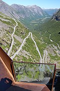 View from the platform
 -
 View from the platform
 -
 Viewpoint
 -
 Viewpoint
 -
 The river
 -
 The river
 -
 The river under the viewing platform
 -

-
 The road down seen from the viewing platform
 -
 Waterfall
 -
 Traffic jam
 -
 Traffic jam
 -
 Trollstiggen
 -
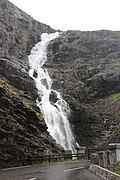 Stigfossen
 -
 Trollstiggen
 -
 Trollstiggen near Stigfossen


.jpg)


See also
[edit]References
[edit]- ^ Aasen, Ivar (1850): Ordbog over det norske Folkesprog. Kristiania: Carl C. Werner
- ^ Norske stedsnavn/stadnamn. Botolv Helleland, Kjell Bondevik. Oslo: Grøndahl. 1975. ISBN 82-504-0104-2. OCLC 2070026.
{{cite book}}: CS1 maint: others (link) - ^ Sunnmørsposten 26 July 2012 p. 12.
- ^ NRK news (accessed 21 September 2012)
- ^ a b Adresseavisen, 10 November 2012.
- ^ Statens vegvesen
- ^ NRK news May 28, 2011 (accessed 23 September 2012)
- ^ Statens vegvesen Archived 2015-04-02 at the Wayback Machine
- ^ "sti - Wiktionary". en.wiktionary.org. Retrieved 2021-07-25.
- ^ "stigr - Wiktionary". en.wiktionary.org. 24 October 2020. Retrieved 2021-07-25.
- ^ NRK (national broadcasting news)
- ^ "Landskapsvernområde" is the lowest level legal protection of landscape http://www.lovdata.no/for/lf/mv/mv-20061124-1305.html
- ^ "Direktoratet for naturforvaltning - Reinheimen nasjonalpark". Archived from the original on 2012-03-14. Retrieved 2012-09-21.
- ^ "Innovativ basestasjon gir bærekraftig 5G på Trollstigen | Telia".
- ^ Sunnmørsposten, 20 May 1995
- ^ Sunnmøringen 24 May 1995
- ^ a b NTB 15 October 1998
- ^ Aftenposten, 11 September 1999, page 17.
- ^ "Trollstigen stenges grunnet rasfare". www.dt.no (in Norwegian). 1999-07-13. Retrieved 2019-08-24.
- ^ Trollstigen åpner fredag. Adresseavisen, 25 May 2000, page 4.
- ^ Bergens Tidende, Monument i Trollstigen, 13 August 2000, page 3
- ^ Ubåtnett sikrer turistene. VG, 30 Juni 2011, p. 47
- ^ Trollstigen stenges. Adresseavisen, 30 August 2002, p. 2.
- ^ Adresseavisen, 21.august 2003
- ^ VG, 15. august 2003
- ^ Romsdals Budstikke, 3.11.2007
- ^ Åndalsnes Avis, 17. november 2011, s.4.
- ^ Aftenposten 24.oktober 2009, ikke oppgitt at den ble åpnet igjen den sesongen.
- ^ Åndalsnes Avis, 17 November 2011, page 4.
- ^ Åndalsnes Avis, 14. mai 2011, s. 5.
- ^ Åndalsnes Avis, 26 November 2011, s. 10 ("stengt inntil videre" - "closed until further notice").
- ^ Adresseavisen, 10 November 2012.
- ^ Romsdals Budstikke på nett accessed 24 May 2013.
- ^ Åndalsnes Avis, Stengt for i år, 14 November 2013.
- ^ Åndalsnes Avis Rekordtidleg opning, 6 May 2014, read 5 May 2018.
- ^ a b Kavli, Evy (2014-11-23). "Trollstigen stenger klokken 16.00 i dag". andalsnes-avis.no (in Norwegian Bokmål). Retrieved 2019-08-24.
- ^ Trafikkmeldinger, Statens vegvesen, read 3 December 2014.
- ^ http://www.vegvesen.no/ Trafikkmeldinger, read 13 December 2014, closed no later than 8 December
- ^ a b Siem, Stein (2018-11-30). "Nærmer seg rekorden". andalsnes-avis.no (in Norwegian Bokmål). Retrieved 2019-08-24.
- ^ Trollstigen åpner for sesongen, 13 May 2015
- ^ "Nå er det vinterstengt" Åndalsnes avis, 28 November 2015, page 3.
- ^ Siem, Stein (2018-11-30). "Nærmer seg rekorden". andalsnes-avis.no (in Norwegian Bokmål). Retrieved 2019-08-25.
- ^ "Spektakulær vei åpnet igjen onsdag". www.tk.no (in Norwegian). 2016-05-25. Retrieved 2019-08-25.
- ^ Brunvoll, Øyvind (2016-11-04). "Vinteren stengte Trollstigen". rbnett.no (in Norwegian Bokmål). Retrieved 2019-08-24.
- ^ Valgermo, Lise Kristin (2017-05-24). "Nå kan sommeren endelig komme til Trollstigen". NRK (in Norwegian Bokmål). Retrieved 2019-08-24.
- ^ Bjerkeland, Øystein (2017-11-13). "Nå er Trollstigen stengt for vinteren". rbnett.no (in Norwegian Bokmål). Retrieved 2019-08-25.
- ^ Brunvoll, Øyvind (2018-05-11). "I dag åpnet Trollstigen!". rbnett.no (in Norwegian Bokmål). Retrieved 2019-08-24.
- ^ Vågnes, Stig (2018-10-26). "Trollstigen vinterstengt – Geiranger åpent". smp.no (in Norwegian Nynorsk). Retrieved 2019-08-26.
- ^ a b NRK (2018-11-16). "Opnar Trollstigen for trafikk". NRK (in Norwegian Nynorsk). Retrieved 2019-08-24.
- ^ Vingen, Anita (2018-12-02). "Stenger Trollstigen". rbnett.no (in Norwegian Bokmål). Retrieved 2019-08-24.
- ^ Lillebakk, Knut Dørum (2019-05-15). "Trollstigen åpner for sesongen". rbnett.no (in Norwegian Bokmål). Retrieved 2019-08-25.
- ^ Turistveger, Nasjonale. "Scenic Routes closed during winter 2019/2020". www.nasjonaleturistveger.no. Retrieved 2020-01-06.
Some of our Norwegian Scenic Route are closed during the winter. Here you can see which routes are open or closed. The table shows statistics for recent years... Scenic Route / The Stretch / Open / Closed Date ... Geiranger - Trollstigen / Trollstigen / ... / 30.10.2019
- ^ Thalberg, Silje (20 June 2024). "Vil ikkje opne Trollstigen utan tiltak i fjellet – stengd ut året". NRK (in Norwegian Nynorsk).
- ^ "Trollstigen stengt! Hva nå for turismen? 🚧". TV 2 (in Norwegian Bokmål). 1 October 2024.
- ^ a b Korsnes, Malin Kjellstadli (12 March 2025). "Vil rassikre Trollstigen i tre år der vegen blir stengd frå 15.august". NRK (in Norwegian Nynorsk).
- ^ "Trollstigen åpnet igjen: - Nesten ny nasjonaldag" (in Norwegian Bokmål). TV 2. 11 July 2025.