
Community hub
Recent from talks
Contribute something
Nothing was collected or created yet.
Zeals
View on Wikipedia
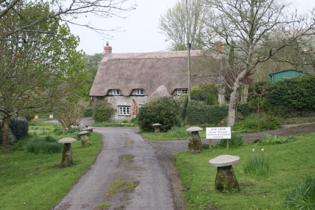
Zeals is a village and civil parish in southwest Wiltshire, England. The village is about 2.2 miles (3.5 km) west of Mere, next to the A303 road towards Wincanton, and adjoins the villages of Bourton, Dorset and Penselwood, Somerset. Its name comes from the Old English sealh meaning a small willow or sallow.
Key Information


The civil parish includes the hamlets of Long Cross, White Cross, Lower Zeals and Wolverton. The River Stour forms the west boundary of the parish.
History
[edit]There are no known prehistoric sites within the modern parish. Nearby on the other side of the Stour valley are Pen Pits, a series of small circular pits where greensand stone was quarried to make querns for hand grinding corn, in the Iron Age, Roman and medieval periods.[2] Also here is Orchard Castle or Castle Orchard, the remains of a medieval motte-and-bailey fortification.[3][4]
In 1086 the Domesday Book recorded two estates at Sele:[5] Lower Zeals (later the Manor of Zeals, or Clevedon) and Higher Zeals (later Zeals Aylesbury). Estimates suggest a population of around 40–50 at Lower Zeals and 85–95 at Higher Zeals at that time.[6]
Zeals was anciently a tithing of Mere parish[7] but was made a separate civil parish in 1896.[8]
A school was provided in 1846, and a larger building erected in 1874 on a site northeast of the church. By 1911 there were 31 infants and 50 older children. A classroom was added in the 1950s, and in 1955 the school gained voluntary controlled status. The village school at Stourton closed in 1965 and pupils transferred to Zeals. New school buildings opened in 1975, immediately north of the old school.[9]
There was a second school, opened in 1840 by Congregationalists at Winbrook, south of Zeals village, and intended for children from Bourton and Penselwood as well as Zeals. When a new Congregational chapel was built in 1856 the school moved into the old chapel, in the same area, and around that time became a British School. Early in the 20th century it was taken over by Wiltshire Council and became Winbrook School. In 1907 there were 70 pupils, but numbers later fell and in 1932 the 41 children transferred to the church school.[10]
The A303 trunk road, taking traffic from London via Andover to Wincanton and the southwest, passed through the village[11] until 1992, when it was diverted to the south.[6]
Notable buildings
[edit].jpg)
Zeals House at Lower Zeals (east of Zeals village) is a Grade I listed former manor house with a 14th-century range. It was owned by the Chafyn family, later the Chafyn-Groves, from the 15th century until the mid 20th. Additions were made in the 17th century and the 1860s, resulting in a large L-shaped country house having a tower with battlemented parapet, one-and-a-half storeys above the rest.[12] In 2001, the ten-bedroom house was sold for £2.4 million.[13]
Four associated buildings are Grade II listed: the small orangery, mid 18th century;[14] the stable block and carriage house, brick, probably late 18th century;[15] a small square dovecote in rubble stone under a pyramidal tiled roof, of similar date;[16] and the granary, early 19th century, in light timber frame and brick.[17] There are lodges at two entrances to the grounds: a pair of small square buildings at the north entrance,[18] and a two-storey stone house dated 1878 at the south.[19]
Zeals has a set of Tudor revival-style almshouses that were built in 1865 for William Chafyn-Grove.[20] Together with the parish hall, they are Grade II listed.[21]
Church and chapels
[edit]
The Church of England parish church of Saint Martin was built using local limestone in 1842–44, to decorated gothic designs by the Gothic Revival architect George Gilbert Scott; it is among his earlier works.[20] Money was raised by Rev. William Frederick Grove, a relative of the Groves of Zeals House,[22] and the Duke of Somerset provided the land.[23] The church was consecrated on 14 October 1846 as a chapel of ease of the parish of Mere, then on 27 June 1848 Zeals was made a separate ecclesiastical parish and St. Martin's became the parish church.[23] In 1876, Julia Chafyn Grove gave money for fittings including the organ, reredos and five of the bells,[22] and for the addition of a spire to the tower.[23] The church was designated as Grade II* listed in 1966.[24]
The benefice was united with Stourton in 1963,[25] and today the church is part of the parish of Upper Stour, alongside Bourton, Kilmington and Stourton.[22]
Zeals had a Congregational chapel from 1832 to 1980[26] and a Methodist chapel from 1852 to 1973.[27]
Amenities
[edit]Whitesheet Church of England Primary Academy, near the church in Zeals village, serves the parish and surrounding area. Since 2003 it has operated on two sites, with younger children attending the school at Kilmington and older children at Zeals.[9]
The village has a pub, the Bell and Crown.[28] The Monarch's Way long-distance footpath passes through Zeals and Wolverton, and the Stour Valley Way crosses the far west of the parish.
Notable people
[edit]Notable members of the Grove family at Zeals House include William Chaffin Grove (c. 1731–1793), lawyer and Member of Parliament for Shaftesbury, and later for the Weymouth and Melcombe Regis seat.[29] A later William Chafyn Grove built the 1865 almshouses as a memorial to his mother.[21] His sister Julia Chafyn Grove (d. 1897) provided Zeals village hall in 1888; her other philanthropy included paying for the building of a school at Mere. She left money for education in Salisbury which resulted in the naming of Chafyn Grove School in 1916.[30]
Herbert Holman, first husband of actress Vivien Leigh, bought Manor Farmhouse (near Zeals House) soon after their divorce in 1940; Leigh often visited him and their daughter Suzanne there. The property was inherited by the daughter (by then Suzanne Farrington) after his death in 1982, and she lived there until her death in 2015.[31]
Zeals airfield
[edit]North of Zeals village, next to the village of Stourton and the Stourhead estate, is the site of the former RAF Zeals, also known as HMS Hummingbird and RNAS Zeals. The airfield operated between May 1942 and June 1946, and during this short time was used by the Royal Air Force, the United States Army Air Forces and the Royal Navy.[32]
Until August 1943 RAF Fighter Command used it as a fighter airfield for Hurricanes and Spitfires.[32] The station was transferred in August 1943 to the USAAF whose initial plan was to use the airfield to maintain C-47 Skytrain transport aircraft. However, the damp conditions prevented heavy loads so P-47 Thunderbolt fighter aircraft were flown from Zeals instead. From March 1944 the airfield reverted to the RAF who posted Mosquito there to intercept incoming German bombers. Following D-Day the RAF used the airfield for glider training in preparation for action against Japan, and in April 1945 the airfield was transferred to the Royal Navy, and was commissioned HMS Heron using the airfield for aircraft carrier training.
The airfield closed on 1 January 1946, although the RN stayed until June 1946 when it was returned to farmland. As of 2006, the control tower, now a private house, remains on Bells Lane in Zeals.
A memorial stands at nearby Beech Clump in Stourton to mark the site where an RAF transport plane crashed on 19 February 1945, killing 21 on board.[33] The plane had taken off from Zeals airfield to return to Leicester after two weeks of glider training and flew into cloud-covered beech trees on the knoll.
References
[edit]- ^ "Wiltshire Community History: Zeals Census Information". Wiltshire Council. Retrieved 15 August 2014.
- ^ Historic England. "Pen Pits quern quarries (1006139)". National Heritage List for England. Retrieved 22 March 2021.
- ^ Historic England. "Orchard Castle (1005639)". National Heritage List for England. Retrieved 22 March 2021.
- ^ Historic England. "Castle Orchard (202574)". Research records (formerly PastScape). Retrieved 22 March 2021.
- ^ Zeals in the Domesday Book
- ^ a b "Wiltshire Community History: Zeals". Wiltshire Council. 19 September 2005. Retrieved 17 March 2007.
- ^ "Zeals in The National Gazetteer of Great Britain and Ireland (1868)". GENUKI. Retrieved 22 March 2021.
- ^ "Zeals CP". A Vision of Britain through Time. University of Portsmouth. Retrieved 22 March 2021.
- ^ a b "Whitesheet Church of England VA Primary School". Wiltshire Community History. Wiltshire Council. Retrieved 23 March 2021.
- ^ "British School, Zeals". Wiltshire Community History. Wiltshire Council. Retrieved 23 March 2021.
- ^ "Ordnance Survey one-inch map, sheet 166". National Library of Scotland. 1959. Archived from the original on 17 August 2022. Retrieved 23 March 2021.
- ^ Historic England. "Zeals House (1318497)". National Heritage List for England. Retrieved 22 March 2021.
- ^ "Zeals House". Zoopla. Retrieved 22 March 2021.
- ^ Historic England. "Orangery at Zeals House (1199651)". National Heritage List for England. Retrieved 22 March 2021.
- ^ Historic England. "Stable blocks and garden wall on north side of Zeals (1199663)". National Heritage List for England. Retrieved 22 March 2021.
- ^ Historic England. "Dovecote to north west of Zeals House (1131074)". National Heritage List for England. Retrieved 22 March 2021.
- ^ Historic England. "Granary to north west of Zeals House (1283243)". National Heritage List for England. Retrieved 22 March 2021.
- ^ Historic England. "Black Dog Lodges and gatepiers (1318499)". National Heritage List for England. Retrieved 23 March 2021.
- ^ Historic England. "New Lodge (1318648)". National Heritage List for England. Retrieved 23 March 2021.
- ^ a b Pevsner, Nikolaus (1975). Cherry, Bridget (ed.). The Buildings of England: Wiltshire. Harmondsworth: Penguin Books. p. 603. ISBN 0-14-0710-26-4.
- ^ a b Historic England. "Chafyn-Grove Cottages and Parish Hall (1318500)". National Heritage List for England. Retrieved 14 August 2015.
- ^ a b c "St Martin's, Zeals". Parish of Upper Stour. 11 May 2018. Retrieved 23 March 2021.
- ^ a b c "Church of St. Martin, Zeals". Wiltshire Community History. Wiltshire Council. Retrieved 14 August 2015.
- ^ Historic England. "Church of St Martin, Zeals (1131078)". National Heritage List for England. Retrieved 14 August 2015.
- ^ "No. 42955". The London Gazette. 29 March 1963. p. 2824.
- ^ "Congregational Chapel, Zeals". Wiltshire Community History. Wiltshire Council. Retrieved 14 August 2015.
- ^ "Primitive Methodist Chapel, Zeals". Wiltshire Community History. Wiltshire Council. Retrieved 14 August 2015.
- ^ "Bell and Crown". Retrieved 14 August 2015.
- ^ Brooke, John. "GROVE, William Chafin (c.1731-93), of Zeals, Wilts". History of Parliament Online. Archived from the original on 28 April 2016. Retrieved 22 March 2021.
- ^ "Inspection Report: Chafyn Grove School" (PDF). Independent Schools Inspectorate. March 2019. Retrieved 22 March 2021.
- ^ Stone, Deborah (25 June 2017). "Revealed: The house Gone With The Wind star Vivien Leigh fell in love with". Sunday Express. Retrieved 21 March 2021.
- ^ a b "King Alfred's Tower - Zeals Airfield". King Alfred's Tower. Zeals online. Archived from the original on 11 August 2016. Retrieved 4 September 2016.
- ^ "Memorial: Crew of Dakota TS436". Imperial War Museums. Retrieved 23 April 2021.
External links
[edit]![]() Media related to Zeals at Wikimedia Commons
Media related to Zeals at Wikimedia Commons
Zeals
View on GrokipediaGeography
Location and administration
Zeals is a village and civil parish situated in southwest Wiltshire, England, approximately 2.2 miles west of the town of Mere.[1] It occupies a position adjacent to Bourton in Dorset and Penselwood in Somerset, with its boundaries encompassing the tripoint where Wiltshire meets these neighboring counties.[7] The village centers on a traditional green, reflecting its rural character at OS grid reference ST780317.[3] Administratively, Zeals was constituted as a civil parish in 1897, separated from the larger Mere parish under the provisions of the Local Government Act 1894, following its earlier formation as an ecclesiastical parish in 1848. Today, it falls within the jurisdiction of the Wiltshire unitary authority, which oversees local governance for the area. The parish encompasses an area of 642 hectares (6.42 km²).[1]Physical features
Zeals is situated on rolling hills in southwest Wiltshire, with elevations ranging from approximately 285 feet (87 meters) to 610 feet (186 meters) above sea level, characteristic of the area's undulating chalk downland terrain.[8] The village lies near the edge of the Cranborne Chase and West Wiltshire Downs Area of Outstanding Natural Beauty (AONB), a landscape defined by expansive chalk grasslands, dry valleys, and rounded downs that reflect the underlying geology of the region.[9] This topography is punctuated by prehistoric features, including bowl barrows on Mappledine Hill to the southeast of the village, which indicate early human activity dating back to the Bronze Age.[2] The area is in close proximity to the River Stour, whose source lies just a few miles east at Stourhead, allowing the river's upper reaches to influence the local hydrology and support adjacent wetlands and valleys.[10] Long-distance footpaths traverse the landscape, with the Stour Valley Way following the river's course through the vicinity west of Zeals, and the Monarch's Way intersecting it nearby, providing access to the surrounding countryside.[11][12] Zeals experiences a temperate maritime climate typical of southwest England, moderated by the Atlantic Ocean, resulting in mild winters with average temperatures around 6°C (43°F) and cool summers rarely exceeding 20°C (68°F).[13] Annual precipitation is relatively high, averaging over 800 mm (31 inches), distributed throughout the year but with a slight winter peak, fostering lush vegetation across the chalk hills.[13]History
Origins and early development
Archaeological evidence indicates prehistoric human activity in the Zeals area spanning multiple periods. Neolithic finds include flint axes recorded near Mere town, while Bronze Age bowl barrows are prominent on Mappledine Hill, located southeast of Lower Zeals. These barrows form part of a broader monumental landscape associated with funerary practices. Iron Age presence is evidenced by nearby hillforts, such as White Sheet Hill on Mere Down, linked to the Durotriges tribe, suggesting settlement and defensive structures in the vicinity.[14][2] Roman influence in Zeals appears limited, with no substantial remains identified within the parish boundaries, though the region lay within the broader territory of Roman Britannia. Early medieval settlement likely consisted of scattered communities within the ancient Forest of Selwood, an area of woodland and pasture that shaped local economy and land use. By the late 11th century, the landscape supported agricultural estates, as recorded in the Domesday Book of 1086, which documented two distinct holdings at "Sele": Lower Zeals, held by Gozelin Riviere (also known as Jocelyn of Rivers), and Higher Zeals, held by Alfgeat. Modern estimates based on Domesday household data suggest populations of approximately 40–50 people at Lower Zeals and 85–95 at Higher Zeals, totaling around 125–145 residents, supported by ploughlands, meadows, pastures, woodlands, and two mills.[15][2] The name Zeals derives from the Old English "sealh," meaning a small willow or sallow tree, reflecting the area's likely vegetation of willow groves; it originally appeared as "Seale" or "Sela" in records and is the only place name in Wiltshire beginning with "Z," a result of regional dialectal voicing of initial "s" to "z." This etymology underscores the Anglo-Saxon linguistic and environmental context of early settlement.[2]19th century onwards
In the early 19th century, religious nonconformity prompted the construction of a Congregational chapel in Zeals in 1832, built on land donated by local landowner John Forward in Fantley Lane.[16] A Primitive Methodist chapel followed in 1852, erected on land likely donated by Benjamin Perfect, accommodating 100 seated worshippers with additional gallery space.[17] Educational provision began with the establishment of the Congregational School, also known as Winbrook School, in 1840, initiated by local philanthropist I.M. Jupe and seven community members to serve children from Zeals and surrounding hamlets; it operated until 1932.[18] The Church of England responded to the area's spiritual needs with the construction of St Martin's Church between 1845 and 1846, designed by George Gilbert Scott and W.B. Moffatt on land donated by the Duke of Somerset and funded primarily by William Frederick Grove, a relative of the Chafyn Grove family of Zeals House.[19] A National School was established adjacent to the church in the same period to provide elementary education, reflecting broader efforts to address poverty and inadequate Anglican facilities in the parish.[20] This school was expanded with a new building in 1874, adding classrooms for younger pupils and a teacher's residence in 1877, enhancing capacity amid growing local population.[20] The late 19th century saw administrative changes, with Zeals separating from the civil parish of Mere following a public meeting in 1895; the new parish council was elected in 1896, formalizing its independent status.[2] During the Second World War, Zeals Airfield operated from 1942 to 1946 as a Royal Air Force station, initially supporting fighter squadrons before use by the United States Ninth Air Force and the Fleet Air Arm, with the site featuring grass runways and protective aircraft pens.[21] Post-war infrastructure improvements included the modernization of the village school, now Whitesheet Church of England Primary School, with new buildings opened in 1975 adjacent to the original site, alongside the addition of a beginners' swimming pool funded by parents in 1976.[22] Transportation evolved significantly with the completion of the Bourton and Zeals Bypass on the A303 in 1992, linking the Mere and Wincanton sections to alleviate traffic through the village and improve regional connectivity at a cost of £15.3 million.[23] In recent decades, Zeals has witnessed shifts in its built heritage, exemplified by the sale of Zeals House, a Grade I-listed manor dating to the 14th century, for £2.4 million in 2001.[24] The property reappeared on the market in 2022 at £5.5 million, with its listing highlighting extensive disrepair requiring substantial restoration to preserve its historical features amid concerns from heritage groups; it was subsequently sold in May 2024 for £3.44 million.[25][24] Community-oriented developments include the approval in 2024 of a planning application by the owners of the Bell and Crown pub to demolish rear outbuildings and expand the outdoor seating terrace, aiming to revitalize the venue while complying with local conservation requirements.[26][27]Demographics
Population statistics
According to the 2021 Census conducted by the Office for National Statistics (ONS), the population of Zeals parish stood at 669 residents.[28] This marked a slight increase from the 658 residents recorded in the 2011 Census and a decrease from the 693 residents in the 2001 Census. The average annual population growth rate between 2011 and 2021 was approximately 0.16%.[29] In terms of gender composition from the 2021 Census, 49.3% of the population were male, while 50.7% were female.[29] The age distribution revealed a relatively aged demographic, with 12.3% of residents under 18 years old, 47.2% aged 18 to 64, and 40.5% aged 65 and over.[29] Ethnically, the 2021 Census indicated that 97.4% of Zeals residents identified as White.[29] Regarding country of birth, 94.5% were born in the United Kingdom.[29] The population density in 2021 was 104 inhabitants per square kilometre.[1]| Census Year | Population |
|---|---|
| 2001 | 693 |
| 2011 | 658 |
| 2021 | 669 |